NGS is Scheduled to Replace NAVD 88 and NAD 83 In 2022 - Indiana Society of Professional Land Surveyors Conference January 2017 John Ellingson ...
←
→
Page content transcription
If your browser does not render page correctly, please read the page content below
NGS is Scheduled to Replace
  NAVD 88 and NAD 83
         In 2022

Indiana Society of Professional Land Surveyors
          Conference January 2017

  John Ellingson – NGS Geodetic Advisor
         john.ellingson@noaa.gov
               202-306-6904
                                                 1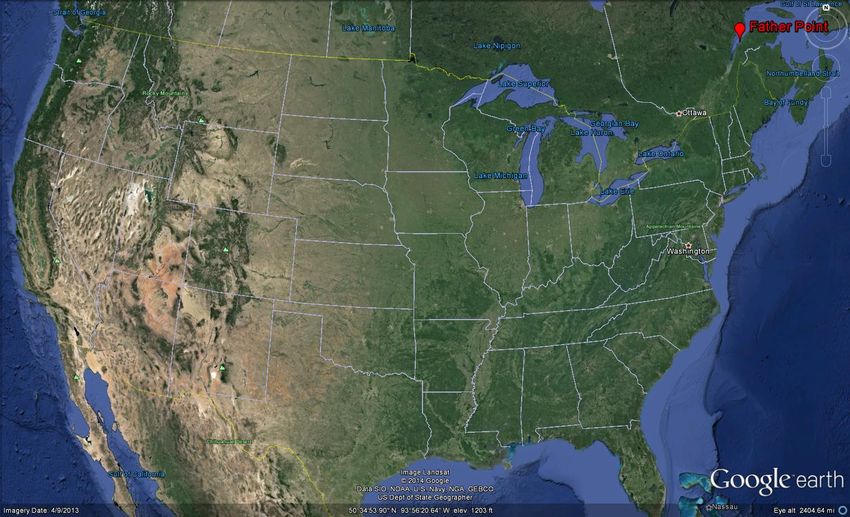
New GEOPOTENTIAL (vertical) datum to
 replace NAVD   88
       Which precipitated a change to…..

 New GEOMETRIC (horizontal/3-D) datum to
 replace NAD   83

Let’s start with the
GEOPOTENTIAL (vertical) datum…..
                                           2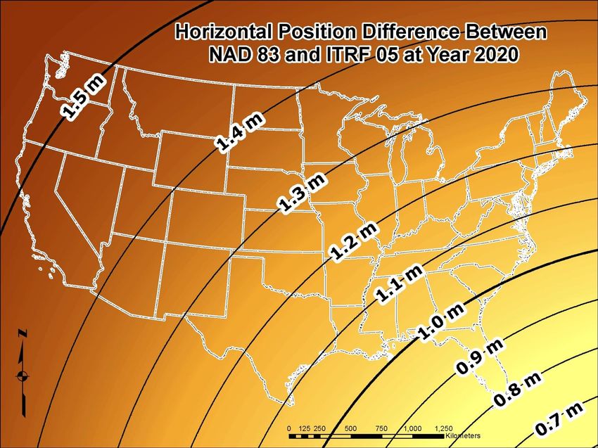
Why isn’t NAVD 88 good
             enough anymore? (1 of 3)
NAVD 88 suffers from bench marks that:
  – Are often 80+ years old
  – Are almost never re-checked for movement
  – Disappear by the thousands every year
  – Are seldom being replaced
  – May not exist near locations where they are needed
  – Were all determined by leveling from a single point,
    allowing unwanted cross-country error build up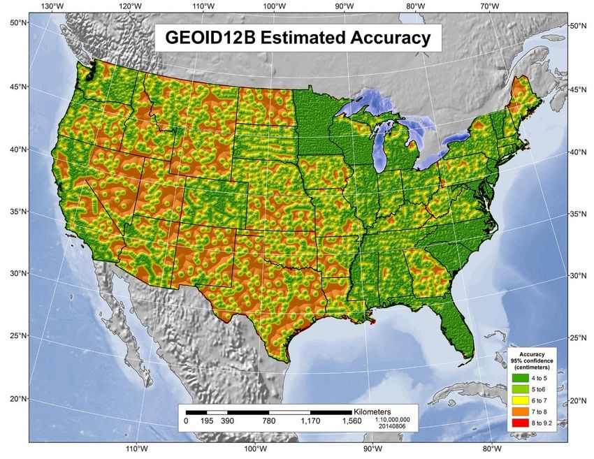
Why isn’t NAVD 88 good
          enough anymore? (2 of 3)
NAVD 88 suffers from a zero height surface that:
  – Has been proven to be ~50 cm biased from the
    latest, best geoid models (“GRACE” satellite
    program)
  – Has been proven to be ~ 1 meter tilted across
    CONUS (again, based on the independently
    computed geoid from the GRACE satellite)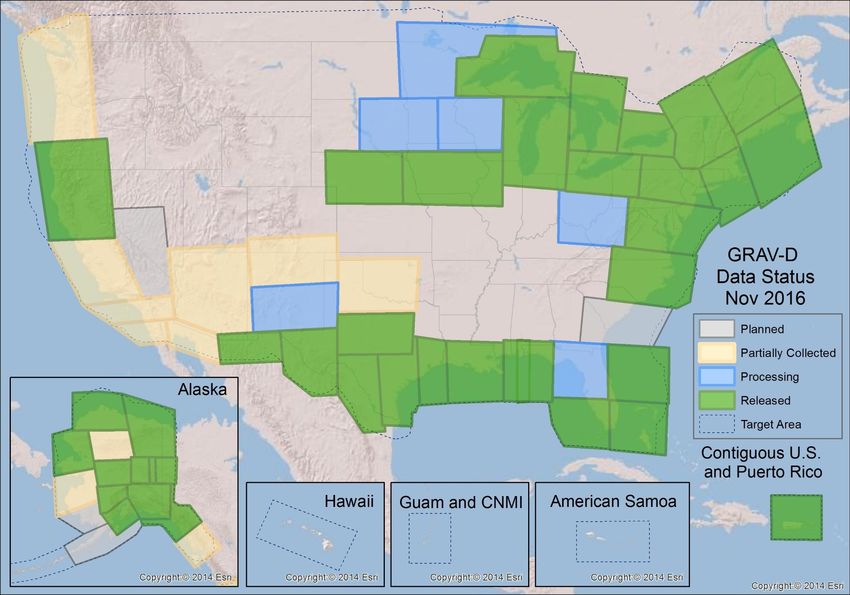
Initial point of NAVD 88 …. “FATHER POINT”
Why replace NAVD 88?
• BIAS of Approximately ½ meter
• KNOWN TILT ..(about a meter) from SE to NW

                                               6
GRACE – (NASA and Germany)
“Gravity Recovery and Climate Experiment”
(launched 2002, expected out-of-service in 2016 – still
going)

GOCE – (European Space Agency)
“Gravity Field and Steady-State Ocean Circulation
Explorer”
(launched 2009, ended November 2013)
                                                          7
Why isn’t NAVD 88 good
           enough anymore? (3 of 3)
Newer methods to determine/establish heights are
available (GNSS), but in many places NAVD 88 doesn’t
support them very well
                          There are areas where
                          NAVD 88 marks are
                          scarce….or do not exist
Geoid                                                                      Geopotential
                                                                                surfaces

                                                                                      Ellipsoid
                                                                                      surface

                                                                           Gravity vector
                                                                           (aka “plumbline”),
                                                                           pointing “up”
The relationships between the ellipsoid surface (solid red), various geopotential surfaces (dashed
blue), and the geoid (solid blue). The geoid exists approximately at mean sea level (MSL). Not shown
is the actual surface of the earth, which coincides with MSL but is generally above the geoid.    9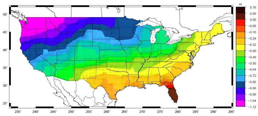
ELLIPSOID - GEOID RELATIONSHIP
H = Orthometric Height (NAVD 88)
h = Ellipsoidal Height (NAD 83 (2011))
N = Geoid Height (GEOID12B)

                                     h       Ground Surface
                                 H

                                         N

            Geoid
                        Geoid
                                             Ellipsoid
                                                 Ellipsoid
                                                 GRS80
           H~h–N
            “N” is negative in conterminous US
                                                              10
11
Gravity for the Redefinition of the American
               Vertical Datum
                   • Overall Target: 2 cm accuracy
                     orthometric heights from GNSS
                     and a geoid model
                   • GRAV-D Goal: Create gravimetric
                     geoid accurate to 1 cm where
                     possible using airborne gravity
                     data
                   • GRAV-D: Two thrusts of the
                     project
                      – Airborne gravity survey of entire
                        country and its holdings
                      – Long-term monitoring of geoid
                        change
                   • Leveraging partnerships to
                     improve and validate gravity data
GRAV-D Website http://www.ngs.noaa.gov/GRAV-D
Data Collection Scope
• Entire U.S. and territories
    – Total Square Kilometers: 15.6
      million (~6 million Sections)
    – ~200 km buffer around territory
      or shelf break if possible
    – Initial target area for 2022
      deadline
Survey and Block Plans
• Data lines spaced 10 km
apart
• Cross lines spaced 60-
80 km apart
• Flight altitude 20,000 ft.
• Nominal speed 220-250
knotsGRAV-D Status 11-30-16: 58%
Properly Scaled Coverage Map

                               20
NGS produces:
• GRAVIMETRIC GEOID:
Converts heights from ITRFxx to the NGS geoid surface
( is not NAVD 88 or other Vertical datums). Used by scientists.
USGG**** ( Last one was completed in 2012 )
• HYBRID GEOID:
Converts heights from NAD 83 to regional Vertical datums
(e.g., NAVD 88). Used by surveyors - engineers - others.
GEOID12B (same model values as GEOID12A in this region)
GEOID12A
GEOID09
GEOID03
GEOID99
GEOID96
• xGEOID16:
Experimental models related to the upcoming 2022 datum changes.
NOT for current NAVD 88 values. Primarily used by scientists. 21The new GEOPOTENTIAL datum should
produce accuracies within 1 to 2 centimeters.
Photo courtesy of RW Engineering & Surveying
Projects that were formerly leveled will most often
obtain vertical control based on GNSS.
22Let’s move on to the
GEOMETRIC (3D)
datum…
23Why replace NAD 83?
NAD 83 was aligned to “Geodetic Reference System
1980” (GRS80), and so was the original “World
Geodetic System 1984 (WGS84) meaning……
NAD 83 IS equivalent to the original WGS 84 …….but
NOT to the newer versions.
Newer versions of WGS 84 have been developed to be consistent with
updated International Terrestrial Reference Frames (ITRFXX)
• G730 (June 1994) 0.7 m
• G873 (January 1997) 0.2 m
• G1150 (January 2002) 0.06 m
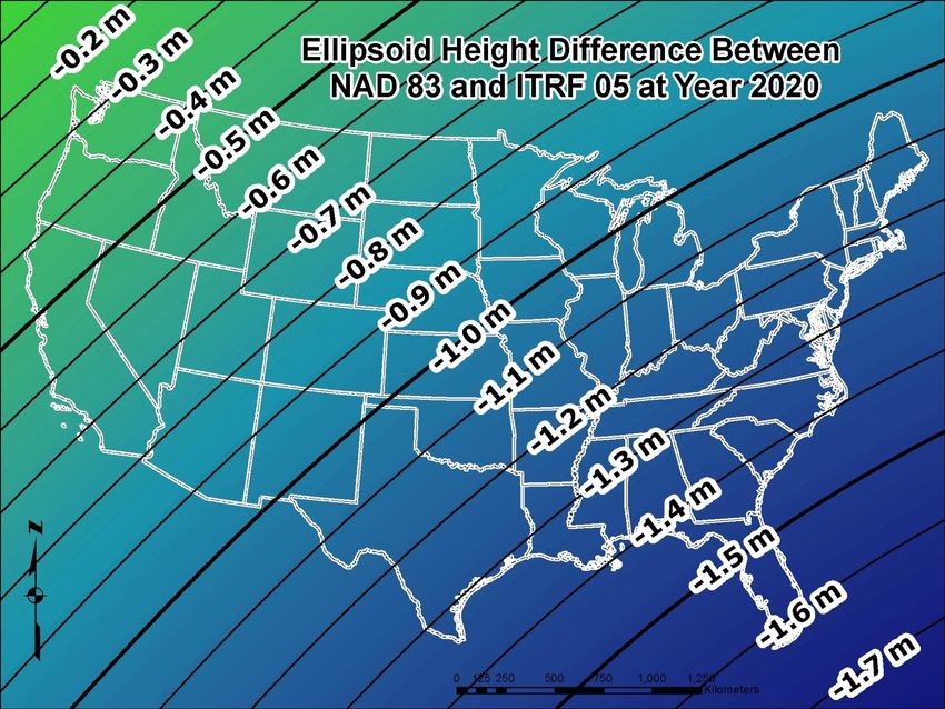
• G1674 (February 2012) 0.01 m 24Sketch showing the difference between
ITRF 2008 and NAD 83
ITRF 08
2527
How will these new datums impact my work?
• Users in this region will see a GEOMETRIC (3-D) shift of about 2 meters

• Users in this region will see a GEOPOTENTIAL (Vert.) shift of about 0.8 m.

• * Some users will delay in switching to the new datums…

     The NGS 10 year plan states that a transformation tool will be
     provided at the release of the new datums that will enable users to
     transform values between the older datums (NAD 83 and NAVD 88)
     and the new GEOMETRIC and GEOPOTENTIAL datums.
                                                                           28
Summary and
Questions
John.Ellingson@noaa.gov
Phone 202-306-6904
http://www.ngs.noaa.gov/datums/newdatums/FAQNewDatums.shtml
http://www.ngs.noaa.gov/GRAV-D/
http://www.ngs.noaa.gov/corbin/class_description/NGS_Video_Library.shtml
29You can also read