NOAA-NGS CORS Network Guidelines for New and Existing Sites and their Relation to IGS - Giovanni Sella, M. Chin, M. Cline, D. Haw
←
→
Page content transcription
If your browser does not render page correctly, please read the page content below
NOAA-NGS CORS Network
Guidelines for New and Existing
Sites and their Relation to IGS

Giovanni Sella, M. Chin, M. Cline, D. Haw,
W. Kass, R. Snay, T. Soler

Spatial Reference Division
National Geodetic Survey
National Oceanic and Atmospheric Administration
Goal
   Upgrade the quality of CORS data and accuracy of
                    associated meta data

                     Why Now?
- The network is mature more than 1 site every 100km
- Driven by VRS networks and success of OPUS (Online
     Positioning User Service)
- Quality versus quantity. Users want improved accuracy
- L2C is here, Galileo on its way and L5 is coming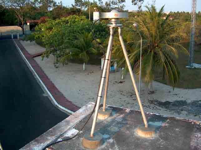
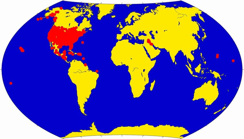
CIGNET (Cooperative International GPS Network)
To CORS (Continuous Operating Reference Stations)
 from ~10 (early 90’s) to ~ 900 stations (April 2006)
Concern

      CORS network is 98% volunteer i.e. non-NGS
             180 different site operators!

- Changes must be consistent with the needs of both NGS
   and site operators
- Guidelines must accommodate a diverse group of site
   operators and data users
- Minimize efforts by NGS for implementing guidelines and
   maximize user access to an accurate National Spatial
   Reference Frame (NSRF)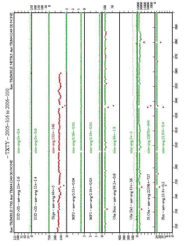
Guidelines

www.ngs.noaa.gov/CORS/Establish_Operate_CORS.html

Provide a set of required and recommended actions for
   establishing and operating a CORS station

Focus is on building on knowledge of the IGS and CORS
  networks over the past 12+ years

Success is achieved by
Ensuring that the guidelines are practical
Explaining WHY we want things done in a particular way
(less phone calls and e-mails!)

First Draft September 2005 Official December 2005
   April 2006 >90% of submissions meet guidelines
Implementation

                Ensure all sites treated equally

Site Selection Team - Assess all new CORS based on
    current guidelines and requests changes if needed. 3-4
    people meet every 2 weeks

Data quality - Establish metrics

Existing sites - Clean up all internal site meta data

Manufacturers - Ensure they are familiar and agree with
  guidelines (give others the ability to do your work)
Guidelines - Stability

Environment
  The space around the antenna should not change for the
  lifetime of the site (minimum 15 years). No vegetation
  growth, additional structures, etc.

            Choose site location carefully

Monument (structure that attaches the antenna to the ground)
  No perfect “monument” therefore none recommended
  Pillar: top surface narrower than antenna
  Sidewall mount: 3 bolts through the mast
  Must have leveling and orienting device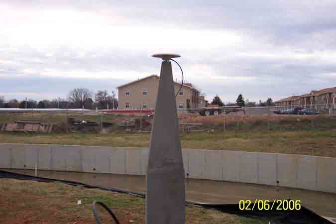
Guidelines - Equipment

Antennas
- Radomes NOT recommended (No cone radomes)
   WHY: distort signal and not required in design of antenna
- Oriented to true North
   WHY: apply antenna phase center values correctly
- Reference mark to antenna reference point (ARP) constant
   WHY: change antenna same coordinate

Receivers
- Cutoff angle 5º required, 0º preferred
   WHY: important for vertical positioning
- Collect hourly files, not daily moving to real-time
   WHY: OPUS and derivative products
Problem wooden support
                        Problem                   U-bolts height can change
                        lightning rod
                        obstructs
                        satellites
                        radome

  Problem tribrach “feet”
cannot be locked height can
    be changed radome

                                         Antennas on
                                         towers with
                                           guy wires
                                        poor stability
Good top
surface of pillar
narrower than
antenna
problem no
orienting &
leveling device
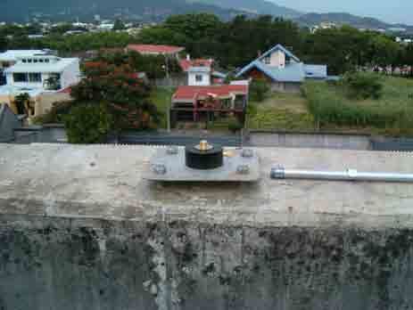
Good orienting &
leveling devices
Good rooftop
with orienting &
leveling deviceGuidelines - Meta-data
As important as the GPS data quality
Site Log - Written record of all equipment ever used and
contact info for a site
NGS will soon (< 1 month) have a web based log file
creator and checker
Check install and remove dates, antenna and radome type
(reduce human error)
Photographs - Visual record of equipment and monument
We require 10-12 photographsRequired photographs 10 for Ground sites 12 for Roof sites Additional e.g. installation/older CRCC photos also archived
Log File Monument Info Classification
Ground Roof
Monument Description : (PILLAR/BRASS PLATE/STEEL MAST/etc) Braced Metal
Height of the Monument : (m)
Monument Foundation : (STEEL RODS, CONCRETE BLOCK, ROOF, etc) Bi In-parapet
Foundation Depth
Marker Description
: (m)
: (CHISELLED CROSS/DIVOT/BRASS NAIL/etc)
Tri Middle
Date Installed : 1996-04-09 Mast Chimney
Geologic Characteristic : (BEDROCK/CLAY/CONGLOMERATE/GRAVEL/SAND/etc)
Bedrock Type : (IGNEOUS/METAMORPHIC/SEDIMENTARY) Tall Other
Bedrock Condition : (FRESH/JOINTED/WEATHERED)
Fracture Spacing : (1-10 cm/11-50 cm/51-200 cm/over 200 cm)
Short Sidewall
Fault zones nearby : (YES/NO/Name of the zone) Pillar Mortar
Distance/activity : (multiple lines)
Additional Information : DOMES number added Narrow Metal
MonuInfo roof tar sidewall mortar Wide Unknown
Unbraced Mortar (tar)
Refusal In-parapet
Bedrock Middle
Add 1 line in Additional Info Unknown Chimney
MonuInfo Other
Sidewall
Mortar
Metal
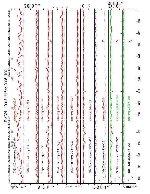
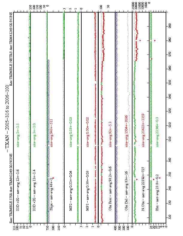
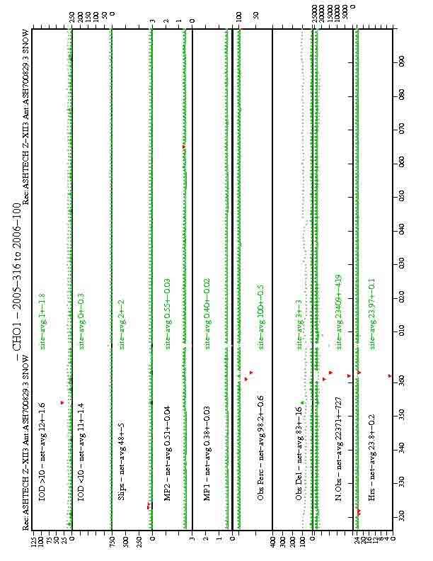
UnknownData Quality Check
Individual site quality assessment is based on a comparison
to the network as a whole, not an arbitrary standard
The worst performing sites will be encouraged to upgrade
and may be dropped from the CORS network
Make plots comprehensive and useful for NGS
AND (more importantly)
Make plots simple so site operators can understand and
show “upper management” if they need to
upgrade/technical help
Use TEQC from UNAVCOReceiver change
Receiver change
Future CORS

Certain
1 St.Croix
1 St. Thomas
1 British Virgin Is.           Possible
1 Puerto Rico             Dominican Republic
3-4 Ethiopia                 Afghanistan
                                Benin
You can also read