NORTH SHORE AREA TRANSIT PLAN - PHASE 1: APPENDIX 1 - BACKGROUND REVIEW - TRANSLINK
←
→
Page content transcription
If your browser does not render page correctly, please read the page content below
North Shore Area Transit Plan
Phase 1: Appendix 1 - Background Review
July 2011

CONTENTS
1.      Land Use ....................................................................................................................................... 2
1.1     Introduction .................................................................................................................................. 2
1.2     Land Use Review ........................................................................................................................... 2
1.2.1   Residential .................................................................................................................................... 2
1.2.2   Commercial and Mixed Use .......................................................................................................... 8
1.2.3   Industrial ....................................................................................................................................... 8
1.2.4   Institutional................................................................................................................................... 8
1.2.5   Parks and Recreation .................................................................................................................... 9
1.3     Regional Policy Context............................................................................................................... 12
1.3.1   Metro Vancouver ........................................................................................................................ 12
1.4     Municipal Policy Context ............................................................................................................ 13
1.4.1   City of North Vancouver ............................................................................................................. 13
1.4.2   District of North Vancouver ........................................................................................................ 14
1.4.3   District of West Vancouver ......................................................................................................... 16
1.4.4   Bowen Island Municipality ......................................................................................................... 16
1.4.5   Village of Lions Bay ..................................................................................................................... 16
1.5     Other Policy Context ................................................................................................................... 16
1.5.1   Vancouver Fraser Port Authority (VPA) ...................................................................................... 16
1.5.2   First Nations ................................................................................................................................ 17
1.6     Major Developments .................................................................................................................. 18
1.6.1   Approved and Active Developments .......................................................................................... 18
1.6.2   Planned and Potential Developments ........................................................................................ 22
2.      Transportation ............................................................................................................................ 26
2.1     Introduction ................................................................................................................................ 26
2.2     Regional Policy Context............................................................................................................... 26
2.3     TransLink Policy Context ............................................................................................................. 26
2.4     Local Policy Context .................................................................................................................... 28
2.4.1   City of North Vancouver ............................................................................................................. 28
2.4.2   District of North Vancouver ........................................................................................................ 30
2.4.3   District of West Vancouver ......................................................................................................... 31
2.4.4   Bowen Island Municipality ......................................................................................................... 31
2.4.5   Village of Lions Bay ..................................................................................................................... 31
2.5     Major Developments .................................................................................................................. 32
2.5.1   Approved and Active Developments .......................................................................................... 32
2.5.2   Planned and Potential Developments ........................................................................................ 32

                                                                                                                                                Page | i
MAPS
Map 1: Current Population Density (2006) ................................................................................................... 3
Map 2: Current Employment Density (2006) ................................................................................................ 4
Map 3: Future Population Density (2041) .................................................................................................... 5
Map 4: Future Employment Density (2041) ................................................................................................. 6
Map 5: Current Housing Types ..................................................................................................................... 7
Map 6: Current Land Use ............................................................................................................................ 10
Map 7: Current Development Areas ........................................................................................................... 11
Map 8: The Regional Growth Strategy’s Land Use Designations (Map 2 of RGS) ...................................... 13
Map 9: District of North Vancouver Draft OCP Network of Centres Concept ............................................ 15
Map 10: Vancouver Fraser Port Authority Planning Areas ......................................................................... 17
Map 11: Squamish Nation Capilano IR 5 Master Plan ................................................................................ 18
Map 12: The Pier Development Site ........................................................................................................... 19
Map 13: Proposed Development of Former Lonsdale School Site ............................................................. 20
Map 14: Rodgers Creek Zoning Amendments ............................................................................................ 21
Map 15: Major Developments (Approved or Potential) ............................................................................. 24
Map 16: Future Frequent Transit Network Concept .................................................................................. 27
Map 17: City of North Vancouver’s Proposed Transit Coverage ................................................................ 29
Map 18: City and District of North Vancouver Bicycle Master Plan ........................................................... 30

                                                                                                                                           Page | ii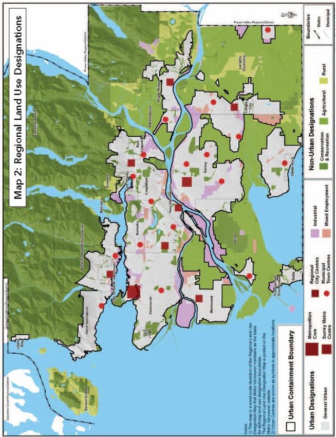
Land Use
1.         LAND USE
1.1      INTRODUCTION
The North Shore is bounded by Burrard Inlet to the south and mountains to the north. The area consists
of five municipalities – City of North Vancouver, District of North Vancouver, District of West Vancouver,
Bowen Island Municipality, and Village of Lions Bay. In addition, there are four First Nation reserves
located in the North Shore area inhabited by either the Squamish or Tsleil-Waututh Nations - Capilano
Indian Reserve No. 5, Mission Indian Reserve No. 1, Seymour Creek Indian Reserve No. 2 and Burrard
Inlet Indian Reserve No. 3.

As of 2006, the total population in the North Shore was 181,300 and is projected to reach 206,600 in
2021, 224,900 in 2031 and 244,000 in 20411. As a sub region, the North Shore has a slower projected
growth rate than the rest of Metro Vancouver. Current and future densities are illustrated in Maps 1 -4.

1.2        LAND USE REVIEW

1.2.1 RESIDENTIAL
The North Shore has traditionally been characterized by single-family residential developments with
pockets of higher density development in various locations. The City of North Vancouver is the urban
core and has the highest density development in the Lonsdale Regional City Centre area. The City plans
to further densify the Central, Lower Lonsdale and Marine Drive sub-areas. West Vancouver is also
encouraging such medium to high density mixed-use development in the Ambleside area, as expressed
in the Ambleside Town Centre Strategy. Lynn Valley Municipal Town Centre in District of North
Vancouver is the final regional centre, anticipated to continue as a concentration of mixed use growth.

Since the 1990s medium to high density re-developments have occurred in Lynn Valley,
Lynnmour/Capilano College, Lower Lynn, Maplewood, and Marine Drive in District of North Vancouver,
as well as parts of Marine Dr. between 15th St. and 27th St., Horseshoe Bay, and areas in the vicinity of
Park Royal/Taylor Way in West Vancouver. These areas feature a mix of densities that also includes
single family. The rest of the North Shore remains primarily single-family detached residential with
Bowen Island primarily having rural residential, as seen in Map 5.

The majority of undeveloped lands on the North Shore are protected as watershed, parks, and limited
use recreation, and some developable land is further limited by dramatic topography, which can
increase development costs. Squamish and Tsleil-Waututh First Nations’ lands on the North Shore
include developable and re-developed areas for a variety of land uses and densities. Although projected
growth rates in the North Shore are slower than regional average2, much of the area’s future growth will
occur through the re-development of existing sites and densification of existing nodes and corridors.

1
    Metro Vancouver, Regional Growth Strategy (RGS), draft January 2011
2
    RGS, draft January 2011

                                                                                                  Page | 2
North Shore Current Population Density
                                                                                                                (2006)
                                                                                                                Map 1

                                                                              North Shore Urban Centres             Edgemont Village
    Legend
           North Shore RGS Urban Centres
                                                                                                                                                                    Lynn Valley
           North Shore Bus Routes                       Lions Bay                                                                               Lonsdale            Municipal
           SeaBus                                                                            Park Royal                                         Regional            Town Centre
           TransLink Bus Routes                                                                                                                 City Centre
    Population Density (persons per hectare)                                  Ambleside
           0 - 20
                                                                              Municipal
                                                    0      750 1,500 Meters
                                                                              Town Centre                                                                       Capilano University
           21 - 50
           51 - 100
           101 - 150                           Bowen Island                                                                       Lonsdale Quay
           151 - 300
           301 - 600                                                                                                                                             Phibbs Exchange

                                           ²
Source: 2006 Statistics Canada Data
                                                                                                Stanley Park Loop
0    500 1,000      2,000   3,000 Meters                                                                                      0   500   1,000    2,000 Meters
                                               0   2,500    5,000 Meters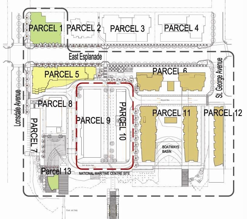
North Shore Current Employment Density
                                                                                                              (2006)
                                                                                                              Map 2

                                                                              North Shore Urban Centres             Edgemont Village
    Legend
           North Shore RGS Urban Centres
                                                                                                                                                                    Lynn Valley
           North Shore Bus Routes                       Lions Bay                                                                               Lonsdale            Municipal
           SeaBus                                                                            Park Royal                                         Regional            Town Centre
           TransLink Bus Routes                                                                                                                 City Centre
    Employment Density (persons per hectare)                                  Ambleside
           0 - 25
                                                                              Municipal
                                                    0      750 1,500 Meters
                                                                              Town Centre                                                                       Capilano University
           26 - 75
           76 - 175
           176 - 325                           Bowen Island                                                                       Lonsdale Quay
           326 - 600
           601 - 1200                                                                                                                                            Phibbs Exchange

                                           ²
Source: 2006 Statistics Canada Data
                                                                                                Stanley Park Loop
0    500 1,000      2,000   3,000 Meters                                                                                      0   500   1,000    2,000 Meters
                                               0   2,500    5,000 Meters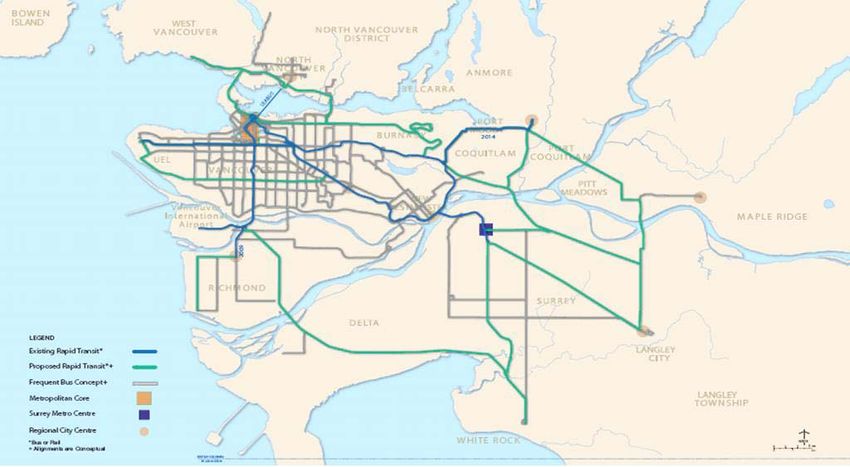
North Shore Future Population Density
                                                                                                     (Projected to 2041)
                                                                                                                  Map 3

                                                                              North Shore Urban Centres             Edgemont Village
    Legend
           North Shore RGS Urban Centres
                                                                                                                                                                    Lynn Valley
           North Shore Bus Routes                       Lions Bay                                                                               Lonsdale            Municipal
           SeaBus                                                                            Park Royal                                         Regional            Town Centre
           TransLink Bus Routes                                                                                                                 City Centre
    Population Density (persons per hectare)                                  Ambleside
           0 - 20
                                                                              Municipal
                                                    0      750 1,500 Meters
                                                                              Town Centre                                                                       Capilano University
           21 - 50
           51 - 100
           101 - 200                           Bowen Island                                                                       Lonsdale Quay
           201 - 300
           301 - 600                                                                                                                                             Phibbs Exchange

                                           ²
Source: Metro Vancouver
                                                                                                Stanley Park Loop
0    500 1,000      2,000   3,000 Meters                                                                                      0   500   1,000    2,000 Meters
                                               0   2,500    5,000 Meters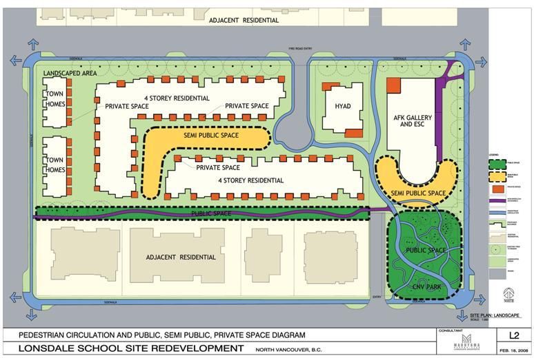
North Shore Future Employment Density
                                                                                                  (Projected to 2041)
                                                                                                               Map 4

                                                                              North Shore Urban Centres             Edgemont Village
    Legend
           North Shore RGS Urban Centres
                                                                                                                                                                    Lynn Valley
           North Shore Bus Routes                       Lions Bay                                                                               Lonsdale            Municipal
           SeaBus                                                                            Park Royal                                         Regional            Town Centre
           TransLink Bus Routes                                                                                                                 City Centre
    Employment Density (persons per hectare)                                  Ambleside
           0 - 25
                                                                              Municipal
                                                    0      750 1,500 Meters
                                                                              Town Centre                                                                       Capilano University
           26 - 75
           76 - 175
           176 - 325                           Bowen Island                                                                       Lonsdale Quay
           326 - 600
           601 - 1200                                                                                                                                            Phibbs Exchange

                                           ²
Source: Metro Vancouver
                                                                                                Stanley Park Loop
0    500 1,000      2,000   3,000 Meters                                                                                      0   500   1,000    2,000 Meters
                                               0   2,500    5,000 Meters
North Shore Housing Types                            Lonsdale
    (Current)                                            Regional
                                                         City Centre

    Map 5
                                           Ambleside                   Lynn Valley
                                           Municipal                   Municipal
                                           Town Centre                 Town Centre

Legend
           North Shore RGS Urban Centres
           North Shore Bus Routes                                                                   Lions Bay
           SeaBus
           TransLink Bus Routes
           Roads
           Single Family Residential
           Low-Rise and Townhouse
           High-Rise Apartment
           Mixed Use
                                                                                                    0   500   1,000 Meters

           Rural Residential

                                                                         Bowen Island

²
0   500 1,000     2,000   3,000 Meters                                   0   1,500   3,000 Meters

Source: Metro Vancouver
1.2.2 COMMERCIAL AND MIXED USE
Major commercial and mixed use areas are located on Lonsdale (including Central and Lower Lonsdale),
Lower Lynn and Ambleside. Park Royal, Capilano Mall and Lynn Valley Centre are the main shopping
malls on the North Shore. Zoning in the Marine Drive corridor in the District of North Vancouver has
recently been changed to allow for developments of mixed-use commercial/residential projects. Other
smaller neighbourhood commercial areas range from pedestrian-oriented villages such as Horseshoe
Bay, Snug Cove, Edgemont, and Deep Cove, to local commercial centres like Parkside, Lower Lynn,
Seymour Parkway (and others) to auto-oriented commercial plazas such as Harbourside/North Shore
Auto Mall.
1.2.3 INDUSTRIAL
Various waterfront industrial facilities are located from the area east of the Second Narrows Bridge to
the area beneath the Lions Gate Bridge. Expansion of North Shore port activities will generally be
accommodated through more extensive activity at existing terminals3. There is no waterfront industrial
activity in West Vancouver, Bowen Island, or Lions Bay.
Most light industrial activities on the North Shore are located close to heavy industry, especially along
the waterfront of North Vancouver. With the opening of the Harbourside Business Park and the North
Shore Auto Mall, many of the auto dealerships and repair shops previously located along Marine Drive
have relocated, clustering in this vicinity. In addition, pressures for increased residential and mixed-use
space are leading to a shift away from light industrial uses. Changes are occurring in the Lower
Lonsdale/Esplanade area in which many auto repair shops have existed although light industrial is seen
as a buffer between the harbour heavy industry and residential in the city. With increasing residential
development locating nearby, this area has experienced a shift towards commercial and live-work space
including artists’ studios. The Main Street area of North Vancouver is also facing a transition in land use
from former light industrial to large surface commercial retailer and auto-oriented commercial
developments. However, the long term vision for the eastern portion of Main Street is to provide the
commercial core of a complete, mixed use community. In general, the North Shore is losing industrial
land to other land uses.
1.2.4 INSTITUTIONAL
The North Shore has 42 elementary schools, 10 secondary schools, and 11 private schools. Bowen Island
and Lions Bay each has a public elementary school; a private middle school is located on Bowen Island.
Capilano University, located in the Lynnmour/Inter-River area in the District of North Vancouver, draws
in students from throughout the Metro Vancouver region, with the majority coming from the North
Shore, Burnaby, and Vancouver.
The North Vancouver Recreation Commission provides 16 recreation and community centres in the City
and District of North Vancouver. The District of West Vancouver has 7 facilities offering similar services.
Bowen Island offers recreational facilities at the Bowen Island Community School and Tunstall Bay Pool.
Lions Bay has one multipurpose community centre.
3
Vancouver Fraser Port Authority, Land Use Plan, January 2008
Page | 8Central Lonsdale features the largest number of institutional uses including City Hall, RCMP station, the
Provincial Court House, a fire hall, Lions Gate Hospital, and a public library. The City of North Vancouver
encourages further institutional uses to locate in this area. In the District of West Vancouver, the
Ambleside area is similar in this respect. Institutional uses in the District of North Vancouver are
distributed among different local centres, and Bowen Island and Lions Bay each have these uses
clustered in their commercial centres.
1.2.5 PARKS AND RECREATION
The North Shore parks and recreational system includes (but are not limited to):
The North Shore Spirit Trail – a 35 km fully accessible waterfront-oriented, multi-use greenway
from Horseshoe Bay to Deep Cove;
“Green Necklace”, an urban greenway system in City of North Vancouver;
Natural parks such as Lynn Headwaters, Lynn Canyon Park, Mosquito Creek Park, and the Lower
Seymour Conservation Reserve;
The Baden Powell Trail and Grouse Grind;
The Capilano Suspension Bridge and park, Cleveland Dam, Capilano Canyon Park, Lynn Canyon
Suspension Bridge, and Lighthouse Park;
Beaches at Cates Park, Ambleside, John Lawson Park, Dundarave, and Whytecliff Park; and
Cypress Mountain, Grouse Mountain, and Mount Seymour.
Waterfront areas and recreational activities on Bowen Island and Lions Bay, at West Vancouver’s
Horseshoe Bay, Eagle Harbour, Caulfeild Cove, and numerous other coves and bays, as well as in
eastern areas of North Vancouver in the waters of Burrard Inlet and Indian Arm, including Deep
Cove.
Page | 9North Shore Land Use
Lonsdale
(Current) Regional
City Centre
Map 6
Ambleside Lynn Valley
Municipal Municipal
Town Centre Town Centre
Legend
North Shore RGS Urban Centres
North Shore Bus Routes Lions Bay
SeaBus
TransLink Bus Routes
Roads
Residential
Industrial
Mixed Use
Rural Residential
0 495 990 Meters
Commercial
Institutional Bowen Island
²
0 500 1,000 2,000 3,000 Meters 0 1,500 3,000 Meters
Source: Metro VancouverNorth Shore Development Areas Lonsdale
(Current) Regional
City Centre
Map 7
Ambleside Lynn Valley
Municipal Municipal
Town Centre Town Centre
Legend
North Shore RGS Urban Centres Lions Bay
North Shore Bus Routes
SeaBus
TransLink Bus Routes
Roads
Non-Residential
Residential
Undeveloped
0 500 1,000 Meters
Protected/Recreational Areas
Bowen Island
²
0 500 1,000 2,000 3,000 Meters 0 1,500 3,000 Meters
Source: Metro Vancouver1.3 REGIONAL POLICY CONTEXT
1.3.1 METRO VANCOUVER
LIVABLE REGION STRATEGIC PLAN (1996)
The document, adopted by GVRD in January 1996, sets out four key growth management strategies:
1. Protecting the green zone;
2. Building complete communities;
3. Achieving a compact metropolitan area; and
4. Increasing transportation choices.
REGIONAL GROWTH STRATEGY (DRAFT JANUARY 2011)
This document is intended to replace the current LRSP and it features five growth management goals:
1. Create a Compact Urban Area
2. Support a Sustainable Economy
3. Protect the Region’s Environment and Respond to Climate Change
4. Develop Complete Communities
5. Support Sustainable Transportation Choices
As seen in Map 8, the draft Regional Growth Strategy (RGS) contains urban development within the
“Urban Containment Boundary”. It also focuses growth around “Urban Centres” and “Frequent Transit
Development Areas”4. There are three designated Urban Centres in the North Shore: Lower Lonsdale
Regional City Centre, and Lynn Valley and Ambleside Municipal Town Centres, where high density
residential and commercial uses will be concentrated. In general, the proposed land use designations in
the Regional Growth Strategy correspond to those contained in the plans of the five Official Community
Plans of the municipalities in the North Shore5. The draft RGS is anticipated to be adopted in 2011.
4
Frequent Transit Development Areas are intended to be the focus for predominantly higher density residential, mixed use,
and local commercial development in suitable locations along transit corridors to provide a higher level of transit access and
promote walkable, convenient communities.
5
Urban Centres are intended to concentrate office, retail, community, entertainment, cultural and institutional uses and higher
density housing
Page | 12Map 8: The Regional Growth Strategy’s Land Use Designations (Map 2 of RGS)
Source: Metro Vancouver Regional Growth Strategy, Draft January 2011
1.4 MUNICIPAL POLICY CONTEXT
1.4.1 CITY OF NORTH VANCOUVER
100 YEAR SUSTAINABILITY VISION (2009)
City of North Vancouver and the University of British Columbia Design Centre for Sustainability (UBC-
DCS) have prepared and published an innovative 100 Year Sustainability Vision for the City. It looks at
likely scenarios, challenges and opportunities in the coming decades, allowing the City to develop more
forward thinking policy planning and to be a better, stronger advocate for regional, provincial and
federal sustainability legislation. This long-range vision aims to guide the City toward carbon-neutral
status by 2107, the City's 200th anniversary.
Page | 13CITY OF NORTH VANCOUVER OFFICIAL COMMUNITY PLAN (2002)
Future growth will be limited to redevelopment and densification. Lonsdale Avenue has been the
traditional town centre of the City and has been identified in the Livable Region Strategic Plan as a
Regional City Centre. The City desires to further develop higher-density residential and mixed-use
developments along Lonsdale Avenue, particularly in Lower and Central Lonsdale, while maintaining the
single-family character of the neighbourhoods to the east and west of the Lonsdale corridor. A new OCP,
currently being developed, is anticipated to be adopted in 2011 or 2012.
1.4.2 DISTRICT OF NORTH VANCOUVER
DISTRICT OF NORTH VANCOUVER OFFICIAL COMMUNITY PLAN (1990)
The OCP includes the following local plans that address neighbourhood issues: Lynn Valley Plan (1998),
Seymour Local Plan (2003), North Lonsdale – Delbrook Official Community Plan (1995), Lower Capilano
Local Plan (1998), Upper Capilano Local Plan (1998), Alpine Area Official Community Plan (1990),
Maplewood Local Plan (2002), Lynnmour/Inter-River Local Plan (2006) and Lower Lynn Official
Community Plan (1993).
DISTRICT OF NORTH VANCOUVER OFFICIAL COMMUNITY PLAN (DRAFT TWO, MARCH 2011)
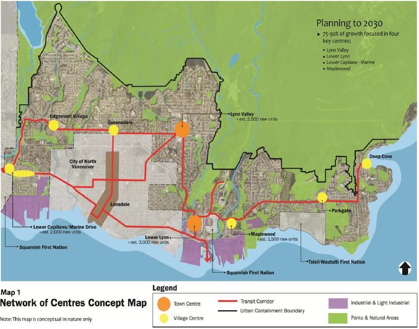
The District of North Vancouver is currently finalizing an update to the OCP. The draft includes a
Network of Centres concept, with a strategy to concentrate 75-90% of future development in four key
locations – Lynn Valley Municipal Town Centre, Lower Lynn, Lower Capilano/Marine and Maplewood.
Two proposed FTDAs, Lower Lynn and Lower Capilano/Marine, are identified in the plan. This draft plan
suggests redevelopment in these areas to higher density residential, commercial and/or institutional
land uses located and designed to support transit, cycling and walking.
Page | 14Map 9: District of North Vancouver Draft OCP Network of Centres Concept
District of North Vancouver, OCP Draft Two, March 2011
MARINE DRIVE IMPROVEMENT STRATEGY (2007)
This document changed all commercial zoning on Marine Dr. from McKay Ave. to the West Vancouver
border to C9 zoning, allowing for higher density and mixed use. Council also requested that District staff
complete a traffic analysis and management plan for the neighbourhoods bordering Marine Dr.
LOWER LYNN CONCEPTUAL LAND USE PLAN
The District of North Vancouver is developing a Conceptual Land Use Plan for the Lower Lynn area.
Lower Lynn presents the opportunity to situate a higher-density residential population close to
employment and accessible to a transit hub (Phibbs Exchange) that connects into the regional public
transportation network. The plan explores the feasibility of creating a complete and sustainable
community in Lower Lynn, which is designated as a Municipal Town Centre in the Metro Regional
Growth Strategy. Council endorsed the staff report in November 2008 and a detailed implementation
program is being developed.
Page | 151.4.3 DISTRICT OF WEST VANCOUVER
DISTRICT OF WEST VANCOUVER OFFICIAL COMMUNITY PLAN (2004)
Some lands north of the Upper Levels Highway and south of the development boundary remain
undeveloped but are designated by the OCP as “future neighbourhoods.” The area includes the
proposed Rodgers Creek development (see Section 1.6).
AMBLESIDE OFFICIAL COMMUNITY PLAN AND ZONING AMENDMENT (2008)
Policies in the OCP amendments include enhancing Ambleside Village Centre as Town Centre by creating
a compact mixed-use area with medium residential and strengthening the connections between the
waterfront and the Centre with increased cultural, recreational and a variety of commercial activities.
1.4.4 BOWEN ISLAND MUNICIPALITY
BOWEN ISLAND MUNICIPALITY OCP UPDATE (DRAFT JULY 2010)
The draft plan aims to limit growth and land development from natural and environmentally sensitive
areas to existing built-up areas. Residential developments will also take place in clusters rather than
large lot subdivision. Snug Cove will continue to be the commercial centre of Bowen Island with mixed
uses.
SNUG COVE MASTER PLAN (2008)
The Plan established the objective of an “Eco-Village in the Park” to provide a framework for sustainable
development in Snug Cove that will see it become a thriving village centre containing a mix of uses
including residential, commercial, park, marine transportation, and community facilities.
1.4.5 VILLAGE OF LIONS BAY
VILLAGE OF LIONS BAY OFFICIAL COMMUNITY PLAN (2002)
This OCP features seven core themes: respecting nature, community strengthening, ensuring a safe
community, maximizing mobility choices, providing effective services, maintaining a sense of place, and
meeting responsibilities in governance. The Village wishes to maintain its single-family character but
permits limited increased density through the addition of secondary suites.
1.5 OTHER POLICY CONTEXT
1.5.1 VANCOUVER FRASER PORT AUTHORITY (VPA)
VANCOUVER FRASER PORT AUTHORITY LAND USE PLAN (2008)
5 of the 11 planning areas are located on the North Shore. Specific land use policies pertaining to these
planning areas are described below.
Page | 16Map 10: Vancouver Fraser Port Authority Planning Areas
Vancouver-Fraser Port Authority, Port Plan, 2005, incorporated in Port Plan 2008.
PLANNING AREA 7 – INDIAN ARM
Intent: for continued use for public marine recreational, vessel anchorage, residential waterfront
moorage and marine commercial uses, where appropriate.
PLANNING AREA 8 – CATES PARK TO SEYMOUR RIVER
Intent: to accommodate a mixture of port industrial, recreational, and conservation uses and develop
mixed-use urban development of the VPA’s Maplewood North property.
PLANNING AREA 9 – SEYMOUR RIVER TO ST. GEORGES AVE.
Intent: for deep-sea terminal and port industrial uses. Further port related development opportunities
for the Pier 94 are will be examined.
PLANNING AREA 10 – ST. GEORGES AVE. TO BEWICKE AVE.
Intent: to support the adjacent upland urban development with marine commercial and limited marine
industrial activities.
PLANNING AREA 11 – BEWICKE AVE. TO LIONS GATE BRIDGE
Intent: for deep-sea terminal, port service and marine industrial operations that require water access.
1.5.2 FIRST NATIONS
CAPILANO IR 5 MASTER PLAN (2004)
The Capilano Master Plan is designed to offer Squamish Nation an indication of land uses that may be
developed on Capilano IR5 over the next 20 years. Land uses include mid to high density mixed use
residential and commercial developments, with areas designated for the Squamish people.
Page | 17Map 11: Squamish Nation Capilano IR 5 Master Plan
Squamish Nation, Capilano IR 5 Master Plan, 2004.
SEYMOUR IR 2
There is potential for a future expansion around the site of the Real Canadian Superstore, located on
First Nations land, outside municipal jurisdiction. The proposed “Seymour Creek Village” project consists
of a retail development similar in size to Park Royal Village in West Vancouver. The project could
potentially add an additional 450,000 sq. ft. of commercial/residential space.
The Squamish Nation also holds land interest in the area under the Second Narrows Bridge, which is
currently leased by the Lynnwood Marina. The Squamish Nation is considering regaining the leasehold
on the Lynnwood Marina and developing it as a 460,000 sq. ft. commercial/industrial park.
1.6 MAJOR DEVELOPMENTS
1.6.1 APPROVED AND ACTIVE DEVELOPMENTS
“THE PIER” DEVELOPMENT
This project by Pinnacle Development is located along Esplanade on former industrial waterfront land.
Once fully completed, the development will include over 1.25 million sq ft of mixed use development,
waterfront walkways with piers, public plazas, a public swimming pool, parks, including 1000 residential
units, a hotel and various commercial spaces. Part of the development has been completed and
occupied and the remaining part will be completed in future phases, although there is no firm
established completion date.
Page | 18Map 12: The Pier Development Site
Source: City of North Vancouver, “Pier Development,” http://www.cnv.org
FORMER LONSDALE SCHOOL SITE6
The North Vancouver School District is developing its former school site on Lonsdale and 22nd Street
into a new 5 storey Education Services Centre with the Artists for Kids Gallery fronting onto Lonsdale.
The western part will be developed into 234 market housing units. The site will also include non-market
housing units for HYAD (Housing for Young Adults with Disabilities).
6
North Vancouver School District 44, “Summary of Proposals,” Public Input Opportunity notice, April 2008
Page | 19Map 13: Proposed Development of Former Lonsdale School Site
Source: City of North Vancouver, “NVSD #44 OCP & Zoning Amendment Applications,”
QUEEN MARY SCHOOL / NVSD ADMINISTRATION SITE7
The current School District office building will be demolished. 4 storey multi-family residential buildings
with a total of about 85 units will be constructed on the site. The Queen Mary School will continue to be
operated. Rezoning application was approved concurrently with the former Lonsdale School site
application by Council on July, 2008.
SEYLYNN VILLAGE DEVELOPMENT8
Construction on the Seylynn Village project, including 690 residential units and 50,000 square feet of
commercial space, is expected to begin in the latter half of 2010 although as of July 2011 has yet to
commence. Over the long term, Seylynn Village is expected to form part of the larger Lower Lynn Town
Centre.
RODGERS CREEK AND CYPRESS PARK ESTATES9
British Pacific Properties Ltd. is developing the Rodgers Creek area, a 215-acre parcel of land located
north of the Upper Levels Highway and below the 1200 ft. elevation development boundary. OCP
amendment, zoning Bylaw amendment, and a Phased Development Agreement (PDA) Bylaw were
7
Ibid
8
Seylynn Village Proposal, District of North Vancouver, http://www.dnv.org
9
Rodgers Creek Area Plan, District of West Vancouver, http://westvancouver.ca
Page | 20approved and adopted by Council on September, 2008. The parcel was rezoned single family zones to
higher density development. It will be divided into 6 neighbourhoods and will allow for mixed use and
public amenity buildings.
Map 14: Rodgers Creek Zoning Amendments
Source: District of West Vancouver, Council Report, June 30, 2008. http://westvancouver.ca
EVELYN DRIVE10
The development is located on four parcels of land between Keith Rd., Park Royal Shopping Centre, Park
Royal Towers, and Taylor Way. In July 2007 Council approved the Evelyn Drive Master Plan. The entire
development will have 349 single/multi-family units. In April 2008 Council approved Development
Permits for the first of four parcels of land being developed. As of March 2011, this project has been
placed in receivership.
MARINE DRIVE
Two mixed use developments are currently under construction within District of North Vancouver’s
portion of Marine Drive. Development at the Marine Drive and Lloyd Avenue intersection will include
129 residential units and around 17,000 square feet of commercial space. The other at Marine Drive and
Bridgman Avenue will include 64 residential units and around 16,000 square feet of commercial space.
1632 LONSDALE
A mixed use development with a 20 storey tower and a 6 storey podium containing 120 residential units
that are approved in the marketing phase. The development also includes a 42,000 square foot grocery
store and street front shops.
10
Evelyn Drive Development, District of West Vancouver, http://westvancouver.ca
Page | 211.6.2 PLANNED AND POTENTIAL DEVELOPMENTS
PIER 94
Pier 94 is located just east of the Burrard Dry Dock at the foot of St. Andrews Ave. in the City of North
Vancouver and is under the jurisdiction of the Vancouver-Fraser Port Authority (VPA). The VPA has
stated in its Port Plan that potential exists for further development of this site and the VPA will be
examining port related development opportunities for the Pier 94 area.11
MAPLEWOOD
In recent years the Maplewood area of North Vancouver has seen increased mixed use and medium
density residential development, as well as the addition of the Northwoods Business Park. Continued
development and redevelopment of commercial floor space is expected through the Districts draft OCP,
which indicates an additional 1,500 residential units could be located here as part of a more complete
community.
MARINE DRIVE
Preliminary applications for mixed use developments have been received for properties at 1171-1177
Marine Drive with 83 residential units and 12,000 square feet of commercial space and at 1265 – 1269
Marine Drive with 24 residential units and 6,000 square feet of commercial space. Further commercial
or mixed use developments are expected along the Marine Drive corridor between Bewicke Avenue and
Lions Gate Bridge.
1200 – 1300 BLOCK LONSDALE
Along with the recently completed Vista Place development (200 units), a new library and renovated
City Hall, four other mixed use buildings are proposed for this immediate area, including over 100,000
square feet of retail/office spaces.
MARINE DRIVE/LOWER CAPILANO ROAD GATEWAY
A sub-area planning process is currently underway for this gateway entrance to the District of North
Vancouver. Preliminary concepts suggest a mixed use area, including retail, institutional uses, and
between 500-1000 multifamily residential units. Planning for this area is occurring as part of the OCP
review and ‘Network of Centre’ land use concept.
LYNN VALLEY TOWN CENTRE
Planning for a mixed use town centre in Lynn Valley has been ongoing for a number of years. Recent
development applications, and the emerging OCP network of centres concept, have meant the Lynn
Valley sub-area planning process has now extended to include periphery residential area. Around 2,500
residential units are expected to be developed over the next 20 years to support a complete, walkable,
transit-oriented community.
11
Vancouver-Fraser Port Authority, Port Land Use Plan, 2005
Page | 22HARBOURSIDE
The final stage of the Harbourside project is now the subject of a policy plan. Approximately 300,000
square feet of commercial space, a waterfront oriented hotel, and 400 residential units might result
from this proposal.
Map 15 provides an overview of major North Shore developments.
Page | 23North Shore Major Developments
(Approved or Potential)
Map 15
Legend
Approved or Active Developments
Planned or Potential Developments
North Shore RGS Urban Centres
North Shore Bus Routes
SeaBus
TransLink Bus Routes
Roads
/
0 500 1,000 2,000 3,000 MetersTransportation
2. TRANSPORTATION
2.1     INTRODUCTION
The North Shore is heavily dependent on the Lions Gate Bridge and Second Narrows Iron Workers
Memorial Bridge to access other parts of the region. The SeaBus connects to bus service at Lonsdale
Quay in North Vancouver and bus, SkyTrain, and West Coast Express commuter rail service at
Waterfront in Vancouver. Because of the dramatic topography, there are only two major east-west
roads connecting North and West Vancouver – Marine Dr. and the Upper Levels Highway. Within North
Vancouver none of the east-west routes directly cross all of North Vancouver. The Upper Levels
Highway, as a major east-west connection, also creates a significant barrier between areas north and
south of the highway.

Some of the greatest concerns related to transportation on the North Shore have been the lack of direct
east-west connections, lack of designated truck routes and direct access to Highway 1, merge points
such as highway interchanges that impede direct east-west connections, capacity and delays at
bridgeheads, and the need for additional transit service.

2.2     REGIONAL POLICY CONTEXT

PROVINCIAL TRANSIT PLAN (2008)
The Plan intends to double transit ridership by increasing travel choice for people around the province,
with the introduction of new fleets, green technology, new rapid transit lines and new innovative
services. “The vision is to be a global leader in providing safe, comfortable, reliable services that will
highlight green technologies and will reshape our communities by encouraging integration of work,
home and recreational activities.”

REGIONAL GROWTH STRATEGY (DRAFT, JANUARY 2011)
Metro Vancouver’s draft RGS will replace the current Livable Region Strategic Plan with similar
transportation policy goals. It includes goals of creating a compact urban area and complete
communities that support sustainable transportation choices. It aims to reduce travel distances and
emphasize transit, cycling, and walking as the priorities; encourage transit and carpooling while
discouraging single occupant vehicles.

2.3     TRANSLINK POLICY CONTEXT

TRANSPORT 2040 (2008)
The plan features the following six goals and four key strategies to achieve them:

Goals
        Greenhouse gas emissions from transportation are aggressively reduced, in support of federal,
        provincial and regional targets.
        Most trips are by transit, walking and cycling.
        The majority of jobs and housing in the region are located along the Frequent Transit Network
        (frequent, reliable services on designated corridors throughout the day, every day).
        Travelling in the region is safe, secure, and accessible for everyone.
        Economic growth and efficient goods movement are facilitated through effective management
                                                                                                  Page | 26
of the transportation network.
Funding for TransLink is stable, sufficient, appropriate and influences transportation choices.
Map 16: Future Frequent Transit Network Concept
Source: TransLink, Transport 2040, July, 2008.
Strategies
Make early investments that encourage development of communities designed for transit,
cycling, and walking.
Optimize the use of the region's transportation assets and keep them in good repair.
Build and operate a safe, secure, and accessible transportation system.
Diversify revenue sources and pursue new and innovative ways to fund transportation.
Transport 2040 is used to guide TransLink’s activities and decision-making, including Area Transit Plans.
Over the next two years, 2040 will be updated at a time when the NSATP will be monitoring the
implementation of near-term priorities. NSATP monitoring and future plan reviews will reflect new
direction and imperatives identified in the updated strategy.
NORTH SHORE AREA TRANSIT PLAN (2000)
The 2000 North Shore Area Transit Plan assumed a significant ridership increase on the North Shore
despite the relatively low population and employment growth rates. This assumption was largely based
on TransLink’s Strategic Transportation Plan (April 2000), including a goal of increasing system-wide
transit use by 29% by 2005. To facilitate this increase, TransLink proposed to:
Increase the bus fleet by approximately 48% to permit more frequent and less crowded services.
Provide a more responsive and flexible bus system, offering a broader range of services,
including new routes, B-Line services, Regional Town Centre connections, and Community
Shuttles.
Page | 27While most improvements have been made, a number of the initiatives identified in the ATP were not
implemented because funding was not available as anticipated, and one initiative was not technically
feasible. Some of the targets identified in the ATP were not measurable within the timeframe of the ATP
plan.
VANCOUVER HARBOUR PASSENGER MARINE STUDY (2003)
Four marine routes were proposed in a previously commissioned study: Snug Cove-Ambleside-
Waterfront; Lonsdale-Ambleside-West End-Kitsilano; Deep Cove-Maplewood-Waterfront; and Ioco-
Maplewood-Lonsdale. Challenges with implementation include limited density surrounding terminal
sites, conflicts arising from use of park land, Ironworkers Memorial Bridge restrictions, vessel emissions,
and acceptance of premium fares. A pilot project was proposed but it did not proceed due to lack of
funding.
2.4 LOCAL POLICY CONTEXT
2.4.1 CITY OF NORTH VANCOUVER
CITY OF NORTH VANCOUVER OFFICIAL COMMUNITY PLAN (2002)
Transportation-related objectives that have been identified in this document include:
Support of transit priority measures (TPMs) as a way to encourage transit use.
Investigating the feasibility of developing park & ride facilities.
Enhancing pedestrian and bicycle corridors
Continuing to install accessible bus stops
Improving road safety
Working with TransLink to maintain the Major Road Network
Encouraging efficient movement between the Lonsdale Regional City Centre and other commercial
centres by means of a variety of local transportation alternatives.
CITY OF NORTH VANCOUVER LONG-TERM TRANSPORTATION PLAN (2008)
Within the Transportation Plan, the Transit Strategy recommends increasing transit frequency and
coverage with conventional and small bus services. The Strategy suggests the desire for new transit
routes, improving accessibility to transit, expanding the Frequent Transit Network, implementing transit
priority treatments, expanding the U-Pass program to Capilano University and examining the potential
for a resident pass program, and expanded SeaBus service with terminal enhancements.
Page | 28Map 17: City of North Vancouver’s Proposed Transit Coverage
Source: City of North Vancouver, Long-Term Transportation Plan, April 2008.
NORTH VANCOUVER BICYCLE MASTER PLAN (2006)
The key component of the Bicycle Master Plan is a network of bicycle routes connecting all major
destinations and all neighbourhoods within the City and District of North Vancouver, as well as
connections to West Vancouver and across Burrard Inlet, and connections to regional transit services.
Page | 29Map 18: City and District of North Vancouver Bicycle Master Plan
City and District of North Vancouver, Bicycle Master Plan, February 2006.
2.4.2 DISTRICT OF NORTH VANCOUVER
DISTRICT OF NORTH VANCOUVER OFFICIAL COMMUNITY PLAN (DRAFT TWO, MARCH 2011)
The draft OCP currently being finalizing finalized by the District includes a Network of Centres concept,
with a strategy to concentrate future development in four key locations linked by transit corridors. Two
proposed FTDAs, Lower Lynn and Lower Capilano/Marine, are identified in the plan. This draft plan
suggests redevelopment in these areas to higher density residential, commercial and/or institutional
land uses located and designed to support transit, cycling and walking. The draft OCP also includes
Town and Village Centre plans for Lynn Valley, Lower Lynn, Maplewood, and Lower Capilano-Marine
areas, with the shared objectives of reducing the need for vehicle trips and improving pedestrian,
bicycle and transit conditions.
The District is in the process of updating its strategic transportation plan. The draft Transit Strategy
seeks to improve transit accessibility and service in the District, supporting the Network of Centres
concept. The draft Strategy intends to set key direction for investment, including prioritizing corridors
for transit service improvements.
Page | 302.4.3 DISTRICT OF WEST VANCOUVER
DISTRICT OF WEST VANCOUVER OFFICIAL COMMUNITY PLAN (2004)
One of West Vancouver’s Planning Principles is to “reduce auto dependency by developing a
comprehensive transit, transportation and land use plan that incorporates convenient and workable
alternatives to the single-occupant car.”
WEST VANCOUVER CYCLING NETWORK AND GREENWAY PLAN (2007)
The two key goals of the plan are to increase cycling and walking trips, and to improve safety for cyclists
and greenway users. The plan is based on a network of bicycle routes, of which the key feature is the
Spirit Trail greenway between Horseshoe Bay and the Lions Gate Bridge, providing connections within
the District of West Vancouver, to North Vancouver, across the Lions Gate Bridge, and connections to
regional transit services.
2.4.4 BOWEN ISLAND MUNICIPALITY
BOWEN ISLAND MUNICIPALITY OFFICIAL COMMUNITY PLAN (2002)
Bowen Island’s objectives for transportation services are to:
Provide safe and efficient transportation
Ensure that transportation services minimize environmental impact and do not encourage
population growth
Encourage alternative transportation to relieve congestion created by private automobile use
BC Ferries connects Bowen Island to Horseshoe Bay in West Vancouver. On land, the OCP encourages a
road system that gives pedestrian precedence over automobile within the Snug Cove village centre.
2.4.5 VILLAGE OF LIONS BAY
VILLAGE OF LIONS BAY OFFICIAL COMMUNITY PLAN (2002)
Recognize that Highway 99 is a controlled access highway and work with the Ministry of
Transportation to determine requirements for future access improvements for the Village;
Encourage multi-modal solutions to transportation issues in the Howe Sound corridor in
conjunction with other service providers;
Reduce dependency on the single occupant vehicle by promoting a car pooling registry;
maintaining and promoting the park and ride facility;
Mitigate the impacts of hiking on the environment, watershed, and community; and
Provide safe and attractive local streets by managing parking.
Page | 312.5 MAJOR DEVELOPMENTS
2.5.1 APPROVED AND ACTIVE DEVELOPMENTS
SEABUS SERVICE INCREASE
Based on the resources available in the 2010 10-Year Plan, the new SeaBus vessel replaced one of the
two old vessels and is currently under operation without any increase to overall service frequency. An
approved 2011 Base Plan maintains current service levels throughout the region. At the time of this
report there has been no approval of a 2011 Supplemental Plan, which included funding for improving
SeaBus evening and weekend service.
LONSDALE QUAY IMPROVEMENTS
This project is intended to provide improvements to the passenger environment within the bus
exchange area of Lonsdale Quay. Some of the objectives of the project include improving lighting to
address problems related to visibility for bus drivers and improving passenger amenities and circulation.
TransLink is working with the City of North Vancouver in developing a Station Area Plan which will lay
out the planning framework and conceptual design for the station at Lonsdale.
LIONS GATE BRIDGE TRANSIT PRIORITY MEASURES
TransLink has been working with the Province of BC, the District of West Vancouver and North
Vancouver on implementation of the Lions Gate Bridge/Marine Drive Transit Priority Study. Bus only
lanes and some signal priority locations are to be installed along Marine Drive from Park Royal to Tatlow
Street, including the Lions Gate bridgehead. Implementation is planned for mid-2011.
GATEWAY
The project involves improvements to Highway 1, the Major Road Network, and the Port Mann Bridge to
create a “gateway” to Asia-Pacific trade. While this project is not located on the North Shore, its
greatest impact on this area will occur with the widening of Highway 1 from 4 lanes to 8 lanes between
Langley and the Second Narrows Bridge. This could result in increased vehicle traffic to the North Shore
via the Second Narrows Bridge. Completion is anticipated by 2013.
2.5.2 PLANNED AND POTENTIAL DEVELOPMENTS
LOWER LEVEL ROAD
A continuous lower level route has been a long term concept. However, there is no specific plan or
timeline as to when it will be implemented. The extension would be contingent on development on the
Squamish First Nations land adjacent to the Lions Gate Bridge.
HIGHWAY 1 INTERCHANGES NEAR SECOND NARROWS BRIDGEHEAD AND LYNNMOUR/INTER-RIVER AREA
The North Shore Interchanges Functional Planning Study by MoT12 proposed some improvements on
Highway 1 interchanges. The potential improvements could involve the addition of lanes at
intersections, the closure of some existing on ramps and off ramps, and the addition of new on ramps,
off ramps, and a direct connection from Keith Rd. to Mount Seymour Parkway.
12
Ministry of Transportation, North Shore Interchanges Functional Planning Study, undated (2007)
Page | 32KEITH ROAD/MOUNT SEYMOUR PARKWAY CONNECTION
The Ministry of Transportation has proposed options in its North Shore Interchanges Functional Planning
Study for new sections of road connecting Keith Rd (west of Lynn Creek) to Mount Seymour Parkway
(east of Lynn Creek) either via Fern Street (current overpass over Highway 1) or by a new direct
connection that would pass over Highway 1 just north of the existing Fern St. overpass, approximately
following the existing northbound Highway 1 on ramp from Mount Seymour Parkway.
SPIRIT TRAIL
North Shore municipalities, provincial government, First Nations, and other agencies are working
together to create the North Shore Spirit Trail, a 35-km fully accessible waterfront-oriented, multi-use
greenway for pedestrians, cyclists, inline skaters and people with wheeled mobility aids that will
potentially connect existing cycling/walking paths with new pathways from Deep Cove to Horseshoe
Bay.
Page | 33You can also read