Out The Window - Caldor Fire smoke, meet Dixie Fire smoke. Views east from the NWS Reno office Monday evening - Mammoth Lakes ...

Page created by Ron Evans
 
CONTINUE READING
Out The Window - Caldor Fire smoke, meet Dixie Fire smoke. Views east from the NWS Reno office Monday evening - Mammoth Lakes ...
Out The Window

Caldor Fire smoke, meet Dixie Fire smoke.
Views east from the NWS Reno office Monday evening.
                                                                           Reno National Weather Service
                                               Forecasting for the Sierra and western Nevada since 1905
Out The Window - Caldor Fire smoke, meet Dixie Fire smoke. Views east from the NWS Reno office Monday evening - Mammoth Lakes ...
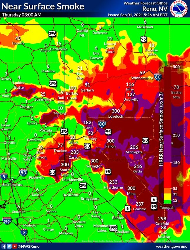
What You Need to Know Up-Front Updated 9/1/21 @ 830 AM PDT
                                                           Key Points

            ●One More Day of Gusty W/SW Winds: Areas of critical fire weather conditions, but not as widespread nor long
             duration as yesterday. Mainly looking at the Sierra Front for those winds over 30 MPH + low humidity. Winds
             lessen a bit starting Thursday and becoming light & variable over the holiday weekend. It will remain fairly dry
             however with limited humidity recoveries especially above valley floors through the weekend.

            ●Smoke - Nothing New Here: Expect to be dealing with degraded air quality into the weekend, especially
             downwind (E/NE) of larger fires. Worst conditions South Lake-Carson City-Carson Valley-Virginia City and
             Lassen/Plumas east across northern Washoe Co. Detailed smoke models only go out 36-48 hours.

            ●Any Moisture? Anything? Even in past active autumns, we haven’t see our first legit Pacific storm until mid to
             late September, and am not seeing anything right now. However our simulations are showing potential for a
             few t-storms early to mid next week. TBD on potential impacts and/or chance of beneficial rains.

                                                     Important Changes
    ● No real changes overnight. Improving signals for some form of thunderstorms at various times next week.

                                                                                                            Reno National Weather Service
2                                                                               Forecasting for the Sierra and western Nevada since 1905
Out The Window - Caldor Fire smoke, meet Dixie Fire smoke. Views east from the NWS Reno office Monday evening - Mammoth Lakes ...
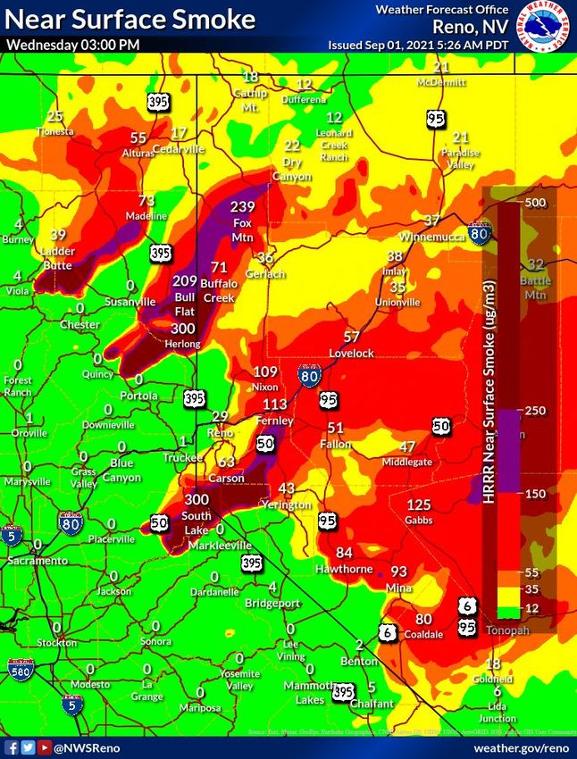
Situational Awareness - When Should I Freak Out?
                        NWS Reno’s 7-14 Day Scan for Upcoming Weather across the Eastern Sierra and Western Nevada
                               Wed 9/1                 Thu 9/2               Fri 9/3              Sat 9/4              Sun 9/5               Mon 9/6                 Tues 9/7           W2 9/8-14

                             Choppy lakes,
                                                    Light W/NW zephyr breezes each day, 15-20 mph. Brief             Light and variable winds, 10-15 mph. A mix of E/NE and
         Wind                isolated road
                                                   period of light east winds Friday morning/early afternoon.                        W/NW wind directions.
                             travel impact.

                                                                                                                                           Could see isolated t-storms E Sierra,     No big wind
                                                                                                                                            mainly Alpine and Mono Counties.        scenarios but
    Thunderstorms                                                          Nothing.                                                        10-20% chance each day. Can’t rule       also no large
                                                                                                                                          out a storm or two up into Tahoe & W      scale wetting
                                                                                                                                                         Nevada.                     rains either.

                                                                                                                                                                                   T-storms possible
       Flooding                                                                                No concerns.                                                                          Wed-Fri next
                                                                                                                                                                                         week.
                              2-4 hours of
                            critical winds &         Not nearly as much wind, but remaining dry with poor humidity recoveries                Still light winds, slightly higher
    Fire Weather
                              low RH, esp                                 especially in mid-slope areas.                                                  humidity.
                              Sierra Front.

                                                   Easing back to near average temps.                                                                                               Favoring near
    Unusual Temps                                                                                                    Warming slightly, but only a few degrees above normal.
                                      Could get somewhat cool Thurs & Fri AM - Sierra valleys freeze.                                                                               normal temps.

                           Dense smoke immediately downwind                Smoke/haze in the region but TBD depending on fire
        Smoke                                                                                                                                              TBD.                          TBD.
                           on major fires. Variable AQ elsewhere.       activity. Lighter winds make smoke prediction less certain.

     What Does This
     Mean? Integrates                              Low                     Moderate                 High
                         No worries                                                                                          Really bad
     impacts and                                   freakoutness            freakoutness             freakoutness
     confidence                                                                                                                                    Reno National Weather Service
3                                                                                                                      Forecasting for the Sierra and western Nevada since 1905
Out The Window - Caldor Fire smoke, meet Dixie Fire smoke. Views east from the NWS Reno office Monday evening - Mammoth Lakes ...
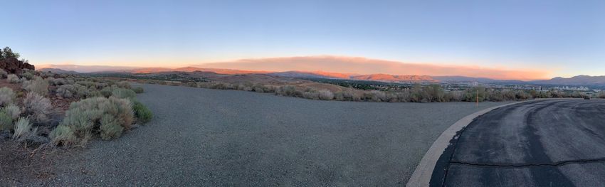
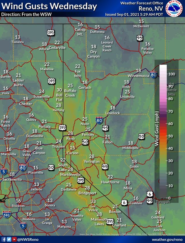
Still Gusty But More Localized Versus Yesterday

                                 W/SW winds gusting on the
                                 order of 25-35 MPH for this
                                  afternoon-evening. More
                                 short-lived localized critical
                                 conditions, primarily along
                                  Sierra Front but also wind
                                   prone locations in other
                                  areas including Tahoe, NE
                                          California.
                                     Critical conditions will
                                    certainly be a factor for
                                 significant ongoing wildfires.

    Winds coming from the SW-W                                                          Reno National Weather Service
4                                                           Forecasting for the Sierra and western Nevada since 1905
Out The Window - Caldor Fire smoke, meet Dixie Fire smoke. Views east from the NWS Reno office Monday evening - Mammoth Lakes ...
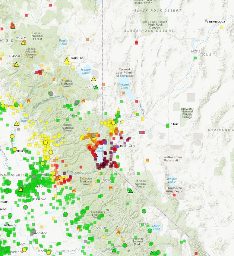
Air Quality Update - Wednesday AM

                                    Link to this map and more data: fire.airnow.gov
                                                                     Reno National Weather Service
5                                        Forecasting for the Sierra and western Nevada since 1905
Out The Window - Caldor Fire smoke, meet Dixie Fire smoke. Views east from the NWS Reno office Monday evening - Mammoth Lakes ...
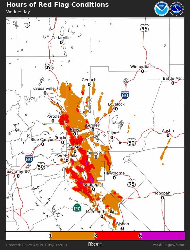
Smoke Outlook: Today and Tonight

                          Diffuse smoke
                        region wide early
                          this morning.
                         Increased SW-W
                         wind speeds will
                        focus the densest
                       smoke immediately
                           downwind of
                        ongoing wildfires
                           with clearing
                          elsewhere this
                            afternoon.

                                                                        Reno National Weather Service
6                                           Forecasting for the Sierra and western Nevada since 1905
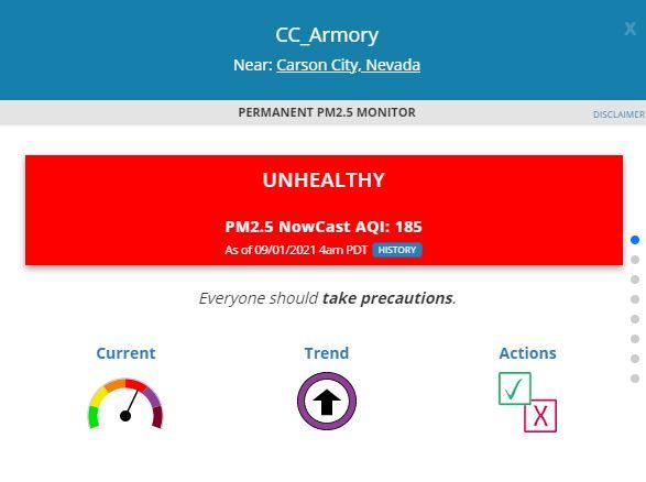
Out The Window - Caldor Fire smoke, meet Dixie Fire smoke. Views east from the NWS Reno office Monday evening - Mammoth Lakes ... Out The Window - Caldor Fire smoke, meet Dixie Fire smoke. Views east from the NWS Reno office Monday evening - Mammoth Lakes ...
You can also read