Palaeontological Impact Assessment for the proposed residential development on 78 North Beach Road, Umdloti, KwaZulu Natal Province
←
→
Page content transcription
If your browser does not render page correctly, please read the page content below
Palaeontological Impact Assessment for the proposed
  residential development on 78 North Beach Road,
          Umdloti, KwaZulu Natal Province

                       Desktop Study (Phase 1)

                                For

                      Confluence Environmental

27 March 2021

Prof Marion Bamford
Palaeobotanist
P Bag 652, WITS 2050
Johannesburg, South Africa
Marion.bamford@wits.ac.za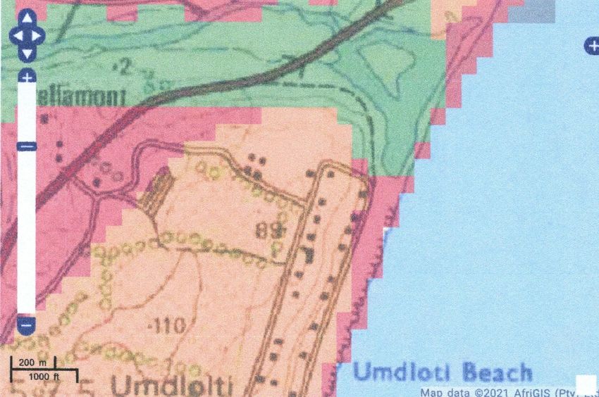
Expertise of Specialist

The Palaeontologist Consultant: Prof Marion Bamford
Qualifications: PhD (Wits Univ, 1990); FRSSAf, ASSAf
Experience: 32 years research; 24 years PIA studies

Declaration of Independence

This report has been compiled by Professor Marion Bamford, of the University of the
Witwatersrand, sub-contracted by Confluence Environmental, South Africa. The views
expressed in this report are entirely those of the author and no other interest was displayed
during the decision making process for the Project.

Specialist: Prof Marion Bamford

Signature:

                                             1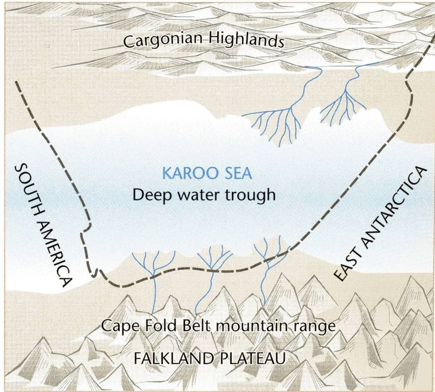
Executive Summary

A Palaeontological Impact Assessment was requested for the proposed residential
development “House Kellerman” for the A & J Kellerman Family Trust on the property 78
North Beach Road, Umdloti, KwaZulu Natal.

In order to comply with regulations of the South African Heritage Resources Agency (SAHRA)
in terms of Section 38(8) of the National Heritage Resources Act, 1999 (Act No. 25 of 1999)
(NHRA), a desktop Palaeontological Impact Assessment (PIA) was completed for the
proposed development.

The proposed site lies on the potentially very highly sensitive rocks of the Vryheid Formation
(Ecca Group, Karoo Supergroup) that could preserve fossils of the Glossopteris flora. The site
however, is close to the beach with destructive sea, windblown sand and natural vegetation.
Furthermore, this location is in the extreme eastern extent of the main Karoo Basin and would
have been below the sea during the Early Permian and such conditions are not conducive to
the growth of terrestrial plants. For these reasons, it is extremely unlikely that any fossils
occur in the project footprint. Nonetheless, a Fossil Chance Find Protocol should be added to
the EMPr. Based on the information it is recommended that no palaeontological site visit is
required unless fossils are revealed once excavations for foundations and amenities have
commenced.

                                              2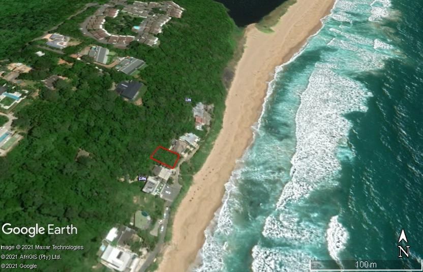
Table of Contents
        Expertise of Specialist.................................................................................................................... 1

        Declaration of Independence ......................................................................................................... 1

1.      Background.................................................................................................................................... 4

2.      Methods and Terms of Reference ................................................................................................. 6

     3i.    Project location and geological context ..................................................................................... 6

     3ii.   Palaeontological context ........................................................................................................... 8

4.         Impact assessment ……………………………………………………………………………………….8
5.      Assumptions and uncertainties .................................................................................................... 11

6.      Recommendation ......................................................................................................................... 11

7.      References .................................................................................................................................. 11

8.     Chance Find Protocol ……………………………………………………………………………………12
Appendix A (examples of fossils) ……………………………………………………………………………14
Appendix B (short CV of specialist) …………………………………………………………………………15

                                                                           3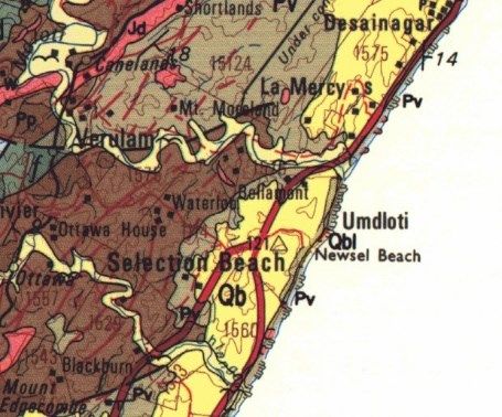
1. Background

The members of the A & J Kellerman Family Trust are proposing to develop the property on
78 North Beach Road, Umdloti, KwaZulu Natal. The project, “House Kellerman” will be a
residential development. There already are buildings and infrastructure along the North
Beach Road (Figure 1) so the site is disturbed.

A Palaeontological Impact Assessment was requested for the House Kellerman project
because it lies on potentially very highly sensitive rocks. To comply with the regulations of the
South African Heritage Resources Agency (SAHRA) in terms of Section 38(8) of the National
Heritage Resources Act, 1999 (Act No. 25 of 1999) (NHRA), a desktop Palaeontological Impact
Assessment (PIA) was completed for the proposed development and is presented herein.

Table 1: Specialist report requirements in terms of Appendix 6 of the EIA Regulations
(amended 2017)

                                                                                                     Relevant
        A specialist report prepared in terms of the Environmental Impact Regulations
                                                                                                     section  in
        of 2017 must contain:
                                                                                                     report

 ai     Details of the specialist who prepared the report                                            Appendix B

 aii    The expertise of that person to compile a specialist report including a curriculum vitae     Appendix B

 b      A declaration that the person is independent in a form as may be specified by the
                                                                                                     Page 1
        competent authority

 c      An indication of the scope of, and the purpose for which, the report was prepared            Section 1

 ci     An indication of the quality and age of the base data used for the specialist report:
                                                                                                     Yes
        SAHRIS palaeosensitivity map accessed – date of this report

 cii    A description of existing impacts on the site, cumulative impacts of the proposed
                                                                                                     Section 5
        development and levels of acceptable change

 d      The date and season of the site investigation and the relevance of the season to the
                                                                                                     N/A
        outcome of the assessment

 e      A description of the methodology adopted in preparing the report or carrying out the
                                                                                                     Section 2
        specialised process

 f      The specific identified sensitivity of the site related to the activity and its associated
                                                                                                     Section 4
        structures and infrastructure

 g      An identification of any areas to be avoided, including buffers                              N/A

 h      A map superimposing the activity including the associated structures and infrastructure
        on the environmental sensitivities of the site including areas to be avoided, including      N/A
        buffers;

 i      A description of any assumptions made and any uncertainties or gaps in knowledge;            Section 5

                                                        4
j A description of the findings and potential implications of such findings on the impact
Section 4
of the proposed activity, including identified alternatives, on the environment
k Section 7,
Any mitigation measures for inclusion in the EMPr
Appendix A
l Any conditions for inclusion in the environmental authorisation N/A
m Section 7,
Any monitoring requirements for inclusion in the EMPr or environmental authorisation
Appendix A
ni A reasoned opinion as to whether the proposed activity or portions thereof should be
N/A
authorised
nii If the opinion is that the proposed activity or portions thereof should be authorised, any
avoidance, management and mitigation measures that should be included in the EMPr, N/A
and where applicable, the closure plan
o A description of any consultation process that was undertaken during the course of
N/A
carrying out the study
p A summary and copies if any comments that were received during any consultation
N/A
process
q Any other information requested by the competent authority. N/A
Figure 1: Google Earth map of the proposed development of House Kellerman on 78 North
Beach Road, Umdloti, shown by the red outline. Map supplied by Confluence.
52. Methods and Terms of Reference
The Terms of Reference (ToR) for this study were to undertake a PIA and provide feasible
management measures to comply with the requirements of SAHRA.
The methods employed to address the ToR included:
1. Consultation of geological maps, literature, palaeontological databases, published and
unpublished records to determine the likelihood of fossils occurring in the affected
areas. Sources included records housed at the Evolutionary Studies Institute at the
University of the Witwatersrand and SAHRA databases;
2. Where necessary, site visits by a qualified palaeontologist to locate any fossils and
assess their importance (not applicable to this assessment);
3. Where appropriate, collection of unique or rare fossils with the necessary permits for
storage and curation at an appropriate facility (not applicable to this assessment); and
4. Determination of fossils’ representivity or scientific importance to decide if the fossils
can be destroyed or a representative sample collected (not applicable to this
assessment).
3. Geology and Palaeontology
i. Project location and geological context
6Figure 2: Geological map of the area around Umdloti on the KwaZulu Natal south coast. The location
of the proposed project is indicated within the red rectangle. Abbreviations of the rock types are
explained in Table 2. Map enlarged from the Geological Survey 1: 250 000 map 2930 Durban.
Table 2: Explanation of symbols for the geological map and approximate ages (Botha, 2018; Johnson
et al., 2006). SG = Supergroup; Fm = Formation; Ma = million years; grey shading = formations
impacted by the project.
Symbol Group/Formation Lithology Approximate Age
(Berea Fm) Umkwelane
Red sand, subordinate Middle Miocene to Pliocene
Qb Fm, Uloa Subgroup,
other sands Ca 10 – 2.5 Ma
Maputaland Group
(Bluff Fm) Umkwelane
Calcarenite, highly Middle Miocene to Pliocene
Qbl Fm, Uloa Subgroup,
calcareous sandstone Ca 10 – 2.5 Ma
Maputaland Group
Jd Jurassic dykes Dolerite dykes, intrusive Jurassic, approx. 180 Ma
Vryheid Fm, Ecca Group,
Pv Shales, sandstone, coal Early Permian, Middle Ecca
Karoo SG
Pietermaritzburg Fm, Dark grey shales, siltstone,
Pp Early Permian, Early Ecca
Ecca Group, Karoo SG sandstone
The site is on the sandstones and shales of the Vryheid Formation in the eastern-most
extent of the Main Karoo Basin. It is overlain by much younger sands of the Maputalnd
Group.
Meltwaters from the Carboniferous glacial ice sheets filled in the Main Karoo Basin, forming
an ancient inland sea. Sediments from the surrounding highlands then gradually filled in the
basin, and as the continent of Gondwana moved northwards and away from its position
over the South Pole, vegetation became established around the margins and deltas. These
are known as the Karoo Supergroup rocks. Dwyka Group diamictites, tillites and mudstones
form the basal strata and are overlain by the Ecca Group mudstones, siltstones and shales.
This group is divided into the Pietermaritzburg, Vryheid and Normandien Formations in the
eastern part of the basin. As the climate continued to warm up and dried out, the Beaufort
Group sediments were deposited, topped by the Stormberg Group and finally capped by the
Drakensberg basalts. All these sediments represent about 120 million years of earth history
(300 – 180 Ma).
Much more recently, the Maputaland Group sands and calcarenites were deposited along
the coast. More detailed mapping and dating techniques have resulted in the stratigraphy of
this group being revised, and the older names are given in brackets because they are used in
the geological map. An overview of the various terms used and the newer terms have been
collated by Botha (2018).
Much younger Maputaland Group sands cover much of the coastal surface. The aeolianites
of the Umkwelane Formation are part of the early Miocene marine transgression that was
followed by epeirogenic uplift, then a eustatic marine regression, starting in the middle
Miocene (Botha, 2018). This marine regression deposited littoral marine sediments on the
7marine planed coastal platform that had incised across the entire range of rock types that
were exposed along the eastern seaboard of southern Africa (ibid). As these sands were
stabilised they have been covered by dense coastal thicket and forest so the root mats have
penetrated the sands, formed soils and further stabilised the coastal sediments.
ii. Palaeontological context
Figure 3: SAHRIS palaeosensitivity map for the site of the proposed House Kellerman shown
within the yellow rectangle. Background colours indicate the following degrees of
sensitivity: red = very highly sensitive; orange/yellow = high; green = moderate; blue = low;
grey = insignificant/zero.
From the SAHRIS map above the area is indicated as very highly sensitive (red) so an impact
assessment is required.
4. Impact assessment
An assessment of the potential impacts to possible palaeontological resources considers the
criteria encapsulated in Table 3:
8TABLE 3A: CRITERIA FOR ASSESSING IMPACTS
PART A: DEFINITION AND CRITERIA
H Substantial deterioration (death, illness or injury). Recommended level will
often be violated. Vigorous community action.
M Moderate/ measurable deterioration (discomfort). Recommended level will
occasionally be violated. Widespread complaints.
L Minor deterioration (nuisance or minor deterioration). Change not
Criteria for ranking of measurable/ will remain in the current range. Recommended level will never
the SEVERITY/NATURE be violated. Sporadic complaints.
of environmental
impacts L+ Minor improvement. Change not measurable/ will remain in the current
range. Recommended level will never be violated. Sporadic complaints.
M+ Moderate improvement. Will be within or better than the recommended
level. No observed reaction.
H+ Substantial improvement. Will be within or better than the recommended
level. Favourable publicity.
L Quickly reversible. Less than the project life. Short term
Criteria for ranking the
M Reversible over time. Life of the project. Medium term
DURATION of impacts
H Permanent. Beyond closure. Long term.
Criteria for ranking the L Localised - Within the site boundary.
SPATIAL SCALE of M Fairly widespread – Beyond the site boundary. Local
impacts H Widespread – Far beyond site boundary. Regional/ national
PROBABILITY H Definite/ Continuous
(of exposure to M Possible/ frequent
impacts) L Unlikely/ seldom
TABLE 3B: IMPACT ASSESSMENT
PART B: ASSESSMENT
H -
M -
L Sands and soils do not preserve any fossils; so far there are no records from
the Vryheid formation of plant or animal fossils in this region so it is very
SEVERITY/NATURE unlikely that fossils occur on the site. The impact would be very unlikely.
L+ -
M+ -
H+ -
L -
DURATION M -
H Where manifest, the impact will be permanent.
L Since only the possible fossils within the area would be fossil plants from the
Glossopteris flora in the shales, the spatial scale will be localised within the
SPATIAL SCALE site boundary.
M -
H -
H -
M -
L It is extremely unlikely that any fossils would be found in the loose sand and
PROBABILITY soils that are heavily vegetated. The site is in the extreme eastern extent of
the Karoo Basin and would have been affected by the ancient sea and by
the present sea and wave action. Nonetheless a Fossil Chance Find
Protocol should be added to the eventual EMPr.
9Based on the nature of the project, surface activities may impact upon the fossil heritage if
preserved in the development footprint. The geological structures suggest that the rocks are
the correct age and type to preserve fossil plant impressions of the Glossopteris flora in the
Vryheid Formation. However, four factors count against this possibility. First, the position is
on the extreme eastern margin of the current landmass but during the early Permian the
future KZN coastline was below water in the Karoo or Ecca Sea and so no plants grew there
(Figure 4; Cadle et al., 1993; McCarthy and Rubidge, 2005). When the super-continent of
Gondwana broke apart and Africa separated from Antarctica, starting around Triassic to
Jurassic times 140 Ma (McCarthy and Rubidge, 2005; Ashwal, 2019) it was a protracted and
violent activity. This breakup has been described as having a rifting stage, wrench stage,
active transform margin phase and finally a thermal subsidence phase from 92–0 Ma (Baby
et al., 2018). Second, the Pliocene uplift and erosion concomitant with sea-level changes
(Maud and Botha, 2000), will have further eroded and affected the coastal rocks, especially
softer shales that might have had fossils. Third, the present day natural vegetation that has
stabilised the sediments with deep penetrating and acid-producing roots, has broken down
the layers and strata. Finally, urban activities and amenities along the coast have affected
the integrity of the strata.
Therefore, it is extremely unlikely that any Vryheid Formation fossil plants were present in
the first place or could have remained, nonetheless, a Fossil Chance Find Protocol has been
added to this report. Taking account of the defined criteria, the potential impact to fossil
heritage resources is extremely low.
Position of the
modern day Durban,
i.e. underwater
Figure 4: Diagram to show the extent of the Karoo Sea during the early Permian (Ecca) times
when the Vryheid Formation was deposited. From McCarthy and Rubidge, 2005, fig 7.21)
105. Assumptions and uncertainties
Based on the geology of the area and the palaeontological record as we know it, it can be
assumed that the formation and layout of the sandstones, shales and sands are typical for the
country and could potentially preserve fossil plant, insect and invertebrate in some parts of
the basin. It is unlikely that the Vryheid Formation strata in the Durban and coastal areas
would have terrestrial fossils because this region was under water (Figure 4). The soils and
sands of the Quaternary period would not preserve fossils.
6. Recommendation
Based on experience and the lack of any previously recorded fossils from the area, it is
extremely unlikely that any fossils of the Glossopteris flora would be preserved in the small
outcrop of Vryheid Formation (Ecca Group, Karoo Supergroup) in this narrow coastal setting
because at the time of its deposition the area was underwater in the Karoo Sea. Very few
vertebrates had evolved by this time and fist were rare. In addition, the area has undergone
rifting and wrenching during the breakup of the super continent Gondwana, and uplift,
erosion and changing sea levels during the Pliocene. Present day natural vegetation has
further disturbed the strata. Nonetheless, there is a very small chance that fossils may occur
in the below ground shales of the early Permian Vryheid Formation so a Fossil Chance Find
Protocol should be added to the EMPr: if fossils are found once excavations for foundations
have commenced then they should be rescued and a palaeontologist called to assess and
collect a representative sample.
7. References
Anderson, J.M., Anderson, H.M., 1985. Palaeoflora of Southern Africa: Prodromus of South
African megafloras, Devonian to Lower Cretaceous. A.A. Balkema, Rotterdam. 423 pp.
Ashwal, L.D., 2019. The 35th Alex Du Toit Memorial Lecture for 2018: Wandering continents
of the Indian Ocean. South African Journal of Geology 122, 397-420.
Baby, G., Guillocheau, F., Boulogne, C., Robin, C., Dall'Asta, M., 2018. Uplift history of a
transform continental margin revealed by the stratigraphic record: The case of the Agulhas
transform margin along the Southern African Plateau. Tectonophysics 731-732, 104-130.
Cadle, A.B., Cairncross, B., Christie, A.D.M., Roberts, D.L., 1993. The Karoo basin of South
Africa: the type basin for the coal bearing deposits of southern Africa. International Journal
of Coal Geology 23, 117-157.
Botha, G.A., 2018. Lithostratigraphy of the late Cenozoic Maputaland Group. South African
Journal of Geology 121, 95-108.
11Johnson, M.R., van Vuuren, C.J., Visser, J.N.J., Cole, D.I., Wickens, H.deV., Christie, A.D.M.,
Roberts, D.L., Brandl, G., 2006. Sedimentary rocks of the Karoo Supergroup. In: Johnson,
M.R., Anhaeusser, C.R. and Thomas, R.J., (Eds). The Geology of South Africa. Geological
Society of South Africa, Johannesburg / Council for Geoscience, Pretoria. Pp 461 – 499.
Maud, R.R., Botha, G.A., 2000. Deposits of the south eastern and southern coasts. In:
Partridge, T.C., Maud, R.R. (Eds.). The Cenozoic of Southern Africa. Oxford University
Press, New York, pp. 19–32.
McCarthy, T., Rubidge, B., 2005. The History of Earth and Life. A southern African
perspective on a 4.6-billion-year journey. Struik Publishers, Cape Town, 333 pp.
Plumstead, E.P., 1969. Three thousand million years of plant life in Africa. Geological Society
of southern Africa, Annexure to Volume LXXII. 72pp + 25 plates.
8. Chance Find Protocol
Monitoring Programme for Palaeontology – to commence once the excavations /
drilling activities begin.
1. The following procedure is only required if fossils are seen on the surface and
when drilling/excavations commence.
2. When excavations begin the rocks and must be given a cursory inspection by the
environmental officer or designated person. Any fossiliferous material (plants,
insects, bone, coal) should be put aside in a suitably protected place. This way
the project activities will not be interrupted.
3. Photographs of similar fossils must be provided to the developer to assist in
recognizing the fossil plants, vertebrates, invertebrates or trace fossils in the
shales and mudstones (for example see Figure 5). This information will be built
into the EMP’s training and awareness plan and procedures.
4. Photographs of the putative fossils can be sent to the palaeontologist for a
preliminary assessment.
5. If there is any possible fossil material found by the developer/environmental
officer/miners then the qualified palaeontologist sub-contracted for this project,
should visit the site to inspect the selected material and check the dumps where
feasible.
6. Fossil plants or vertebrates that are considered to be of good quality or scientific
interest by the palaeontologist must be removed, catalogued and housed in a
suitable institution where they can be made available for further study. Before
12the fossils are removed from the site a SAHRA permit must be obtained. Annual
reports must be submitted to SAHRA as required by the relevant permits.
7. If no good fossil material is recovered then no site inspections by the
palaeontologist will be necessary. A final report by the palaeontologist must be
sent to SAHRA once the project has been completed and only if there are fossils.
8. If no fossils are found and the excavations have finished then no further
monitoring is required.
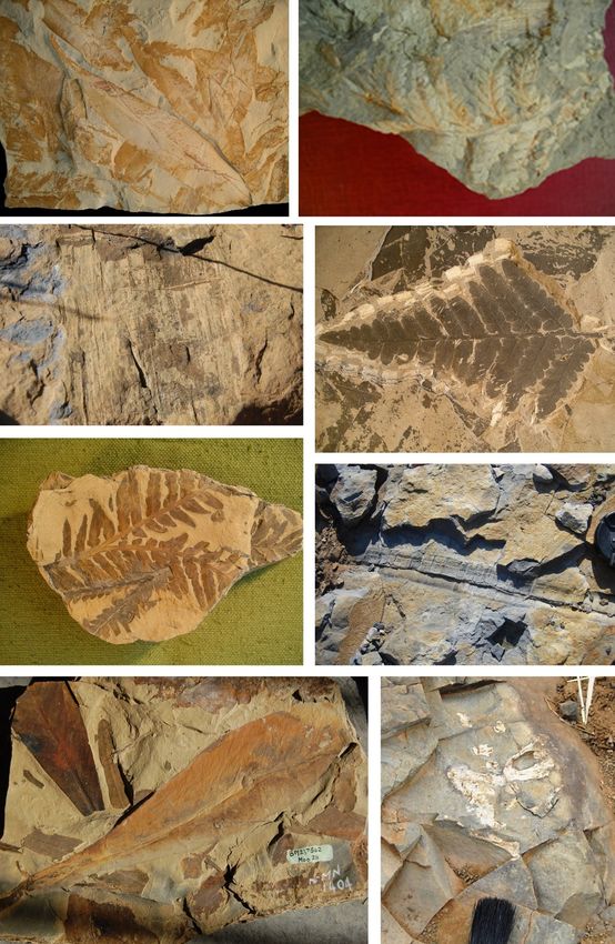
13Appendix A – Examples of fossils from the Vryheid Formation farther inland
Figure 5: A selection of fossil plant impressions from the Glossopteris flora from the Vryheid
Formation near Johannesburg. Bottom right shows fossil bones in situ from the lower
Beaufort Group.
14Appendix B – Details of specialist
Curriculum vitae (short) - Marion Bamford PhD
January 2021
I) Personal details
Surname : Bamford
First names : Marion Kathleen
Present employment : Professor; Director of the Evolutionary Studies Institute.
Member Management Committee of the NRF/DST Centre of
Excellence Palaeosciences, University of the Witwatersrand,
Johannesburg, South Africa-
Telephone : +27 11 717 6690
Fax : +27 11 717 6694
Cell : 082 555 6937
E-mail : marion.bamford@wits.ac.za ; marionbamford12@gmail.com
ii) Academic qualifications
Tertiary Education: All at the University of the Witwatersrand:
1980-1982: BSc, majors in Botany and Microbiology. Graduated April 1983.
1983: BSc Honours, Botany and Palaeobotany. Graduated April 1984.
1984-1986: MSc in Palaeobotany. Graduated with Distinction, November 1986.
1986-1989: PhD in Palaeobotany. Graduated in June 1990.
iii) Professional qualifications
Wood Anatomy Training (overseas as nothing was available in South Africa):
1994 - Service d’Anatomie des Bois, Musée Royal de l’Afrique Centrale, Tervuren, Belgium, by
Roger Dechamps
1997 - Université Pierre et Marie Curie, Paris, France, by Dr Jean-Claude Koeniguer
1997 - Université Claude Bernard, Lyon, France by Prof Georges Barale, Dr Jean-Pierre Gros,
and Dr Marc Philippe
iv) Membership of professional bodies/associations
Palaeontological Society of Southern Africa
Royal Society of Southern Africa - Fellow: 2006 onwards
Academy of Sciences of South Africa - Member: Oct 2014 onwards
International Association of Wood Anatomists - First enrolled: January 1991
International Organization of Palaeobotany – 1993+
Botanical Society of South Africa
South African Committee on Stratigraphy – Biostratigraphy - 1997 - 2016
SASQUA (South African Society for Quaternary Research) – 1997+
15PAGES - 2008 –onwards: South African representative
ROCEEH / WAVE – 2008+
INQUA – PALCOMM – 2011+onwards
vii) Supervision of Higher Degrees
All at Wits University
Degree Graduated/completed Current
Honours 11 0
Masters 10 4
PhD 11 4
Postdoctoral fellows 10 5
viii) Undergraduate teaching
Geology II – Palaeobotany GEOL2008 – average 65 students per year
Biology III – Palaeobotany APES3029 – average 25 students per year
Honours – Evolution of Terrestrial Ecosystems; African Plio-Pleistocene Palaeoecology;
Micropalaeontology – average 2-8 students per year.
ix) Editing and reviewing
Editor: Palaeontologia africana: 2003 to 2013; 2014 – Assistant editor
Guest Editor: Quaternary International: 2005 volume
Member of Board of Review: Review of Palaeobotany and Palynology: 2010 –
Review of manuscripts for ISI-listed journals: 25 local and international journals
x) Palaeontological Impact Assessments
Selected – list not complete:
• Thukela Biosphere Conservancy 1996; 2002 for DWAF
• Vioolsdrift 2007 for Xibula Exploration
• Rietfontein 2009 for Zitholele Consulting
• Bloeddrift-Baken 2010 for TransHex
• New Kleinfontein Gold Mine 2012 for Prime Resources (Pty) Ltd.
• Thabazimbi Iron Cave 2012 for Professional Grave Solutions (Pty) Ltd
• Delmas 2013 for Jones and Wagener
• Klipfontein 2013 for Jones and Wagener
• Platinum mine 2013 for Lonmin
• Syferfontein 2014 for Digby Wells
• Canyon Springs 2014 for Prime Resources
• Kimberley Eskom 2014 for Landscape Dynamics
• Yzermyne 2014 for Digby Wells
• Matimba 2015 for Royal HaskoningDV
• Commissiekraal 2015 for SLR
• Harmony PV 2015 for Savannah Environmental
• Glencore-Tweefontein 2015 for Digby Wells
16• Umkomazi 2015 for JLB Consulting
• Ixia coal 2016 for Digby Wells
• Lambda Eskom for Digby Wells
• Alexander Scoping for SLR
• Perseus-Kronos-Aries Eskom 2016 for NGT
• Mala Mala 2017 for Henwood
• Modimolle 2017 for Green Vision
• Klipoortjie and Finaalspan 2017 for Delta BEC
• Ledjadja borrow pits 2018 for Digby Wells
• Lungile poultry farm 2018 for CTS
• Olienhout Dam 2018 for JP Celliers
• Isondlo and Kwasobabili 2018 for GCS
• Kanakies Gypsum 2018 for Cabanga
• Nababeep Copper mine 2018
• Glencore-Mbali pipeline 2018 for Digby Wells
• Remhoogte PR 2019 for A&HAS
• Bospoort Agriculture 2019 for Kudzala
• Overlooked Quarry 2019 for Cabanga
• Richards Bay Powerline 2019 for NGT
• Eilandia dam 2019 for ACO
• Eastlands Residential 2019 for HCAC
• Fairview MR 2019 for Cabanga
• Graspan project 2019 for HCAC
• Lieliefontein N&D 2019 for EnviroPro
• Skeerpoort Farm Mast 2020 for HCAC
• Vulindlela Eco village 2020 for 1World
• KwaZamakhule Township 2020 for Kudzala
• Sunset Copper 2020 for Digby Wells
• McCarthy-Salene 2020 for Prescali
• VLNR Lodge 2020 for HCAC
• Madadeni mixed use 2020 for EnviroPro
xi) Research Output
Publications by M K Bamford up to December 2019 peer-reviewed journals or scholarly
books: over 150 articles published; 5 submitted/in press; 10 book chapters.
Scopus h-index = 29; Google scholar h-index = 35; -i10-index = 92
Conferences: numerous presentations at local and international conferences.
xii) NRF Rating
NRF Rating: B-2 (2016-2020)
NRF Rating: B-3 (2010-2015)
NRF Rating: B-3 (2005-2009)
NRF Rating: C-2 (1999-2004)
17You can also read