Modes and Structural Conditions of Large Scale Mass Movements (Sackungen) on Crystalline Basement Units of the Eastern Alps (Niedere Tauern, Austria)
←
→
Page content transcription
If your browser does not render page correctly, please read the page content below
© Naturwissenschaftlicher Verein für Steiermark; download unter www.biologiezentrum.at

c        Mitt, naturwiss. Ver. Steiermark           Band 130        S. 31-42      Graz 2000

  Modes and Structural Conditions of Large
    Scale Mass Movements (Sackungen) on
 Crystalline Basement Units of the Eastern Alps
            (Niedere Tauern, Austria)
        By Siegfried Willibald H E R M A N N 1 , Gregor M A D R I T S C H 2 , H e l m u t R A U T H 3
                               a n d Leander Peter BECKER 1
                                        W i t h 8 Figures

                                A n g e n o m m e n am 2. September 2 0 0 0

      Zusammenfassung: Erscheinungsbilder gefugekontrollierter Großhangbewegungen (Sackun-
gen) im kristallinen Grundgebirge der Ostalpen (Niedere Tauern, Österreich). - Im Kristallin der
Niederen Tauern sind Großhangbewegungen weitaus häufiger als bisher bekannt. An ausgewählten Sackun-
gen innerhalb der Wölzer Glimmerschiefer werden die morphologischen Merkmale und die Beziehung von
Lagerungsverhältnissen der Gesteine zu morphostrukturellen Endgliedern von Sackungen aufgezeigt. Fol-
gende Endglieder von Sackungen können unterschieden werden: (a) Wenn die Hauptfoliation der Geisteine
hangauswärts geneigt ist, weist die Sackung eine deutlich reduzierte Hangneigung gegenüber stabilen
Hängen auf. Am Fuß der Sackung ist deutlich ein Talzuschub entwickelt. Der Oberhang weist im Detail
komplexe Geometrien der Abriß- und Bergzerreißungszone auf, ihre morphologischen Erkennungsmerk-
male sind aber nur undeutlich, (b) Sackungen, die an Hängen mit hangeinwärts orientierten und steil
stehenden Flächengefügen entwickelt sind, weisen konvexe Hangprofile und in der Kammregion markante
Bergzerreißungsphänomene, wie Doppelgrat- und Grabenstrukturen auf. Die durchschnittliche Hangnei-
gung dieses Typs von Sackung ist gegenüber stabilen Hängen aber nicht verflacht. Alle Sackungen weisen
stets individuelle Entwässerungsnetze auf, sind empfindlicher gegenüber Erosion und sekundären Massen-
bewegungen als stabile Bereiche und verwischen glazial gebildete Formen.

      Abstract: Along the Niedere Tauern mountains many more sagging-type mass movements occur than
are known so far. To examine the morphological characteristics of two opposite modes of occurrence, we
illustrate six examples, which all are evolved within micaschist lithologies. The following end members can
be outlined: (a) Saggings that occur on slopes where the main foliation of the rocks dips roughly parallel to
the slope are characterised by a remarkable decrease of the average slope inclination with respect to stable
slopes beside and by closing up of the valley ("Talzuschub")- Their upper slope portions record complex but
morphologically not very strongly-developed mountain splitting structures, (b) In contrast, saggings on
slopes where the dip of the principle foliation is into the slope, a convex slope profile without remarkable
decrease of the average slope inclination are developed. However, those examples record expressive moun-
tain splitting, including double crested ridges and ridge top grabens in upper slope portions. The average
slope inclination of this type of sagging is not different to stable neighbouring slopes. Slopes that are affected
by sagging in general indicate individual drainage patterns, provoke secondary landslides, are susceptible to
enhanced erosion and degenerate the glacially-shaped landscape.

                                             1. Introduction
    Large portions of the central Upper Styria district were mapped in detail for the
occurrence of large scale mass movements in the course of MSc theses (RAUTH 1996,

1
    UA Mag. Dr. Siegfried W. HERMANN und Univ. Prof. Dr. Leander Peter BECKER, Institut für Geologie u.
Paläontologie d. Universität Graz, Heinrichstraße 26, A-8010 Graz, e-mail: siegfried.hermann@kfunigraz.ac.at
2
   Mag. Gregor MADRITSCH, Büro Plankl-Petz & Partner, Schöndorfplatz 6, 5400 Hallein
3
   Mag. Helmut RAUTH, Lendorfgasse 13, 9061 Klagenfurt

                                                                                                              31
© Naturwissenschaftlicher Verein für Steiermark; download unter www.biologiezentrum.at
MADRITSCH 1999) as well as PhD theses (HERMANN 1997) to make evident the frequen-
cy of Sackung-type slope instabilities on the Niedere Tauern mountains (Fig. 1).
The family of landslides we discuss here include mass movements of veiy slow
creeping or dormant constitution and they are in the dimension up to several square
kilometers. These mass movements include the phenomenon of mountain splitting in
upper slope portions, (first described by AMPFERER 1939 as "Bergzerreißung") and
bulging toes in lower slope portions. The latter is often connected with the closing up of
the valley (termed "Talzuschub" by STINY 1941). Both phenomena later were attributed
to the term "Sackung" by ZISCHINSKY 1966. Nowadays the meaning of Sackung corre-
sponds to the English term "sagging of mountain slopes" as defined by HUTCHINSON
1988, the term "lateral spreading of ridges" as defined by JAHN 1964 and the term "deep-
reaching gravitational slope deformations" as defined by DRAMIS & SORRISO-VALVO
1994.
From the response of gravitational forces, especially steep sided ridges on high
mountain slopes, are susceptible to Sackung-type mass movements. During the Würmian
glacial period an up to 1700 meter thick ice shield covered the central portions of the
Eastern Alps, including the Niedere Tauern mountain chain (VAN HUSEN 1981, 1987).
Main valleys are therefore glacially-molded and characterised by symmetrical U-shaped
cross sections. We have recognized that the pre-glacial valley floor in the region of
Pusterwald was located 500 metres higher than present and in the region of the Sölk
Fig. 1: Distribution of Sackung-type mass movements in northern portions of the Niedere Tauern
mountains, the Schladminger Tauern mountains and the Wölzer Tauern mountains, respective-
ly (state of knowledge: April 2000) and the allocation of sites mentioned in this paper: ®: site
Weißgulling - Mt. Brennkogel, ®: site Schwarzgulling - Mt. Hintergullingspitz, ®: site
Scharnkzengraben - Mt. Hühnerkogel, ©: site Bärental - Mt. Hoher Zinken, ©: site Groß-
sölktal - Mt. Moditzen, ©: site Großsölktal - Mt. Ebeneck
Verbreitung von Sackungskörpern (Kenntnisstand April 2000) im Nordteil der Niederen
Tauern (Schladminger Tauern und den Wölzer Tauein) und Lage der im Text erläuterten
Fallbeispiele: ®: Weißgulling - Brennkogel, ©: Schwarzgulling - Hintergullingspitz, ®: site
Scharnitzengraben - Hühnerkogel, ©: Bärental - Hoher Zinken, ©: Großsölktal - Moditzen,
©: Großsölktal - Ebeneck.valleys©itNaturwissenschaftlicher
was even located up Verein für Steiermark;
to a maximum download
of 1200 metresunter www.biologiezentrum.at
higher than present. As a
consequence high slopes are frequent in the Niedere Tauern.
Here, we contribute to the morphologic and topographic features of sagging of
mountain slopes in contact with crystalline host rock lithologies. We do so by illustrating
six examples, selected out of 35 that we detected. These examples are developed on
similar lithologies and are appropriate to emphasize the spectrum of surface morpho-
logical features, accompanying mass-movements and their control by the structural and
metamorphic fabrics.
2. Lithology and structural setting
The six examples presented here all are in contact with the Wölz micaschist complex
that covers the north-easternmost part of the Schladminger Tauern and main part of the
Wölzer Tauern (Fig. 1). The Wölz micaschist complex is made up of silicielastics and
marbles that may be derived from a shelf environment of suggested Silurian to Devonian
age (BECKER 1981). The complex is intruded by swarms of Permian pegmatites. This
basement forms a crustal scale anticlinal structure with north dipping schistosity in the
northern part and south dipping schistosity in the southern part of the area of investiga-
tion.
Two main overprints at amphibolite facies metamorphic conditions can be detected
from radiometric data (e.g. HEJL, 1984) as well as structural and petrological analysis
(APART & MARTINELLI 1991). These overprints resulted in the development of a pene-
trative foliation forming the main fabric. Exceptionally for the northernmost portions of
the Wölz crystalline complex is that there occurred a greenschist facies metamorphic
overprint during lower Cretaceous (Eoalpine) stacking of the Austroalpine nappe com-
plex. This overprint is accompanied by non-coaxial deformation and deformation of
phyllonitic schists.
In addition three more sets of foliations can be distinguished: (i) domains of a north
dipping transversal crenulation cleavage that becomes a penetrative fabric in the sur-
roundings of the Enns valley. This implies that this fabric most probably is related to an
early stage of escape tectonics (WANG & NEUBAUER 1998). (ii) NW-SE directed and
ENE-WSW directed cataclastic faults that form crosscutting fabrics of brittle structures
and were developed during Miocene strike slip deformation and (iii) consistently NNE-
SSW striking sets of master joints. The principle drainage network is controlled by these
brittle fabrics.
In the following section we will give a brief description of the characteristic morpho-
logical features of Sackungen. The maps and photos presented reflect surface morpholog-
ical structures at that time of field seasons and may change in future times. The figures
2 and 3 were generated by RAUTH during field season 1995 (RAUTH 1996), figure 4 was
generated by MADRITSCH during field seasons 1997 and 1998 (MADRITSCH 1999),
figures 6 and 7 were generated by HERMANN during field seasons 1994 and 1995
(HERMANN 1997). Figure 5 is a detail of the ÖLK 10 (Austrian Orthophoto Map) map
sheet number 5328-102 and was shot 1986.
At each sub-section, 3.1 to 3.3 two sites are discussed together for the following
reasons: (i)firstly,both examples at each subsection 3.2, 3.2 and 3.3 were mapped by the
co-authers, RAUTH, MADRITSCH and HERMANN, respectively, (ii) secondly they are
develoved on slopes of comparable lithology and structure and (iii) finally because of the
neighbourhood of the saggings in each subsection we can assume equal slope morpho-
metric conditions before sagging was initiated. By discussing two examples in each
subsection it is easy to compare neighbouring examples by contrasting their different
morphologies.
33© Naturwissenschaftlicher Verein für Steiermark; download unter www.biologiezentrum.at
3. Examples
3.1. Sackung Weißgulling - Mt. Brennkogel (number 1 in Fig.l)
and Sackung Schwarzgulling - Mt. Hintergullingspitz (number 2 in Fig. 1)
The uppermost portion of the Gulling valley splits into two parallel valley segments
(Fig. 1), the Schwarzgulling valley to the south and the Weißgulling valley to the north
(Fig. 2). The ridge in between these valleys consequently is aligned parallel to ENE-WSW
directed cataclastic fault zones (HERMANN 1997). The schistosity is gently and consistent-
ly dipping to the north (Fig. 2). Straight-lined mountain splitting structures between
mount Brennkogel and mount Hintergullingspitz, including double crested ridges, mul-
tiple crested ridges and ridge top grabens. Closing up of central portions of Weißgulling
valley indicate deep reaching slope instabilities in both directions, to the south and to the
north (Fig. 2).
At mount Brennkogel an E-W trending single scarp in the manner of a single normal
fault geometry can be traced along a distance of 1100 meters. That structure generates an
asymmetric half graben indicating movement to the north and therefore a Sackung type
slope instability towards the Weißgulling river. East of mount Brennkogel the single
scarp splits into a set of multiple scarps to form an area of mountain splitting. Below that
area rock fall debris and blocky talus is deposited. West of mount Brennkogel main scarp
is accompanied by uphill facing scarps. These form counterscarps of antithetic displace-
ment but also a broad ridge of mountain splitting. Multiple crested ridges near the cote
1848 elevation are developed as their morphological expression. There, ephemeral ponds
are fixed to the exposure of displacement surfaces (Fig. 3).
Foliation attitude
y Gully, pipe
( ^ Glacial terraces
^ / Trench
•*£•- Scarp of double crest
300m J* ( Continuous talus deposits
J V Fan deposits
^ } Scarp of shallow slide 'V Rockfall debris
Fig. 2: Morphological map of site Weißgulling - Mt. Brennkogel (1) and Schwarzgulling - Mt.
Hintergullingspitz (2). For location see Fig.l.
Morphologische Karte der Hangbewegungen Weißgullingtal - Brennkogel (1) und Schwarzgul-
lingtal - Hintergullingspitz (2). Lage siehe Fig.l.
34© Naturwissenschaftlicher Verein für Steiermark; download unter www.biologiezentrum.at
Brennkogel
Fig. 3: The multiple crested ridge at Mt. Brennkogel was generated by synchronous displacement of
conjugate synthetic normal faults (single scarps and double crests) and antithetic faults (uphill
facing scarps). The rigde top valley of the main scarp in the foreground is traced by an ephemeral
pond.
Mehrfachgrate am Brennkogel bilden sich durch gestaffelt angeordnete Abriße an konjugiert
entwickelten Abschiebungsbahnen, synthetische Abschiebungen erzeugen Einfach- und Dop-
pelgrate, anithetische Abschiebungen erzeugen hangparallele Leisten (Uphills). An das Kamm-
tälchen der Hauptabrißkante ist ein Nackensee (Vordergrund) gebunden.
West of the Hintergullingspitz a single scarp forms an impressive ridge top valley of
strong asymmetry. The scarp can be traced more than one kilometer. The maximum
displacement in central portions is about 120 meters. Below this (at Hintergulling —
"Aim" at cote 1508 elevation), glacial terraces are down shifted by the same amount. In
contrast to the Brennkogel the scarp at mount Hintergullingspitz indicates displacement
to the south facing slope towards the Schwarzgulling river. It's western branch leads into
numerous minor scarps as well as counterscarps to form an area of mountain splitting.
The eastern branch of the scarp at the Hintergullingspitz overlaps the western branch of
the scarp at the Brennkogel and consequently form bilateral gravitational spreading of the
mountain ridge as shown by JAHN 1964 and HUTCHINSON 1988.
Those portions of the slopes which are affected by Sackung-type mass movements
systematically are drained by shallow gullies and pipes (Fig. 3). The sub-parallel pattern
of this type of drainage can also be used as indicator for instabilities and is in contrast to
the more dendritic drainage pattern of the neighbouring stable slopes. As a further
indicator for slope instabilities, dismembering of glacial molded plateau areas on the
convex bulging slope to the Weissgulling river was noticed.
3.2. Sackung Scharnitzgraben - Mt. Hühnerkogel (number 3 in Fig. 1)
and Bärental - Mt. Hoher Zinken (number 4 in Fig. 1)
Mesoscale open folds at site mount Hühnerkogel are formed by the east and west
dipping foliation planes, whereas a flat lying foliation at site mount Hoher Zinken was
35© Naturwissenschaftlicher Verein für Steiermark; download unter www.biologiezentrum.at
recognised. Both, the Scharnitzen valley and the Bärental valley, delineate a subordinate
NE-SW trending drainage system with respect to the Pustertal valley (Fig.l). They follow
one of the main joint sets (MADRITSCH 1999) and portray NW exposed glacial cirque
landscape of basin like surface geometry.
At each of these examples, mountain splitting can be noticed along a distance of
several kilometers, concentric copying the glacial cirques of upper most portions of at the
Scharnitzen valley and the Bärental valley. Local drainage network and shallow gullies
run radially from alpine pasture towards the central bottom of the glacial cirques. This is
very well-demonstrated at the example Bärental - mount Hoher Zinken (Fig. 4). At that
site east of the Hoher Zinken a complex mountain splitting area is controlled by the
interaction of main scarps and counterfacing scarps to generate microscale horst and
graben structures. Particularly down slope to the north a large rotational landslide is
located (Fig. 4).
Fig. 5 illustrates how two prominent scarps form a well-defined triple-crested ridge
structure near mount Hühnerkogel. Towards the saddle Stallertörl this structure trans-
forms into a set of en enchelon oriented scarps. The north facing slope towards valley
Scharnitz is characterised by terraced slope morphology including uphill facing counter
scarps, which frequently carry small ephemeral ponds. North of the Hühnerkogel an
active block glacier as indicated by a steep front at an elevation of 2100 meters within a
coarse talus occurs.
3.3. Sackung Moditzen (number 5 in Fig. 1) and
Sackung Ebeneck (number 6 in Fig. 1)
The examples of mount Moditzen and Ebeneck are located near the Sölktal-linea-
ment (TOLLMANN 1977) which represents an antithetic dextral strike slip fault with
(ISM;
Fig. 4: Morphological map of site Bärentäl - Mt. Hoher Zinken (4). For location see Fig.]
Morphologische Karte der Sackung Bärental - Hoher Zinken (4). Lage siehe Fig.l.© Naturwissenschaftlicher Verein für Steiermark; download unter www.biologiezentrum.at
respect to the Ennstal fault system (HERMANN 1997). In the surroundings of the NNW-
SSE oriented Sölktal valley, NNE-SSW directed subvertical master joints do control local
drainage network (see Fig. 1), e.g. the Kleinsölktal valley and the Strickertal valley.
Morphometric conditions of mount Moditzen show relics of an table mountain,
which is not a very common relief within the crystalline basement of the Niedere Tauern
mountains. The plateau is exposed from 1920 meter to 1970 meter elevation and forms
a gentle NE dipping rectangle square north to the peak of mount Moditzen. This plateau
Fig. 5: © BEV - 2000, Vervielfältigung mit Genehmigung des BEV - Bundesamtes für Eich- und
Vermessungswesen in Wien, ZI. 38163/00. Orthofotographic view of site Schamitzengraben —
Mt. Hühnerkogel (3). (detail of ÖLK 10, sheet number 5325-102, Wildalmhütte). Two main
zones of gravitational displacement (arrows mark main scarp and record the direction of
movement) are forming a three times crested rigde including two main ridge-top graben north
and nortwest of Mt. Hühnerkogel. Near the saddle Stallertörl ridge top grabens transform into
en enchelon oriented crests of mountain splitting. Black cross lines mark the front slope of a
block glacier.
Orthofoto-Ansicht der Sackung Scharnitzgraben - Hühnerkogel (3), (Ausschnitt aus ÖLK 10,
Blatt 5325-102, Wildalmhütte). Wien. Zwei Hauptabschiebungen generieren einen Dreifach-
grat nördlich und nordwestlich des Hühnerkogel (Pfeile markieren Abrißkanten und weisen in
Bewegungsrichtung. Am Sattel Stallertörl leiten die zwei Kammgräben in gestaffelte Zerrgräben
einer Bergzerreißungszone über. Die schwarzen Kreuze markieren die Stirn eines Blockglet-
schers.
37© Naturwissenschaftlicher Verein für Steiermark; download unter www.biologiezentrum.at
_t_ Modirzen
single scarp
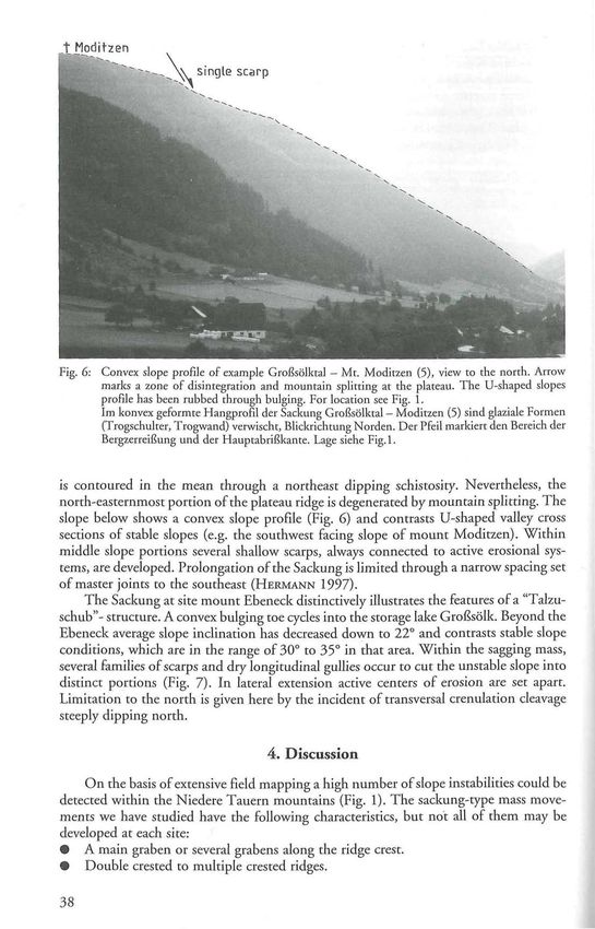
Fig. 6: Convex slope profile of example Großsölktal - Mr. Moditzen (5), view to the north. Arrow
marks a zone of disintegration and mountain splitting at the plateau. The U-shaped slopes
profile has been rubbed through bulging. For location see Fig. 1.
Im konvex geformte Hangprofil der Sackung Großsölktal - Moditzen (5) sind glaziale Formen
(Trogschulter, Trogwand) verwischt, Blickrichtung Norden. Der Pfeil markiert den Bereich der
Bergzerreißung und der Hauptabrißkante. Lage siehe Fig.l.
is contoured in the mean through a northeast dipping schistosity. Nevertheless, the
north-easternmost portion of the plateau ridge is degenerated by mountain splitting. The
slope below shows a convex slope profile (Fig. 6) and contrasts U-shaped valley cross
sections of stable slopes (e.g. the southwest facing slope of mount Moditzen). Within
middle slope portions several shallow scarps, always connected to active erosional sys-
tems, are developed. Prolongation of the Sackung is limited through a narrow spacing set
of master joints to the southeast (HERMANN 1997).
The Sackung at site mount Ebeneck distinctively illustrates the features of a "Talzu-
schub"- structure. A convex bulging toe cycles into the storage lake Großsölk. Beyond the
Ebeneck average slope inclination has decreased down to 22° and contrasts stable slope
conditions, which are in the range of 30° to 35° in that area. Within the sagging mass,
several families of scarps and dry longitudinal gullies occur to cut the unstable slope into
distinct portions (Fig. 7). In lateral extension active centers of erosion are set apart.
Limitation to the north is given here by the incident of transversal crenulation cleavage
steeply dipping north.
4. Discussion
On the basis of extensive field mapping a high number of slope instabilities could be
detected within the Niedere Tauern mountains (Fig. 1). The sackung-type mass move-
ments we have studied have the following characteristics, but not all of them may be
developed at each site:
• A main graben or several grabens along the ridge crest.
• Double crested to multiple crested ridges.© Naturwissenschaftlicher Verein für Steiermark; download unter www.biologiezentrum.at
Uphill-facing scarps or counter-scarps.
Ephemeral ponds.
Bulging of the lower part of the slope.
Closing up of the valley.
Occurrence on the upper flanks of glaciated valleys.
A local relief of more than 500 meters.
The assemblage of these features as a result of near surface strain can be explained by
the reorganisation of pre-existing discontinuities. That causes higher porosity and lower
resistance to erosion. Consequently all the slopes which are affected by Sackungen
indicate an individual drainage pattern, and carry secondary landslides (see Fig. 4 and
Fig. 7). We suggest that numerous rock fall debris and coarse blocky talus can be assigned
to the presence of Sackungen (see Fig. 2 and Fig. 5).
Fig. 7: Morphostructural map of site Großsölktal — Mt. Ebeneck (6). For location see Fig. 1.
Morphostrukturelle Karte der Sackung Großsölktal — Ebeneck (6). Lage siehe Fig. 1.
39© Naturwissenschaftlicher Verein für Steiermark; download unter www.biologiezentrum.at
It is widely accepted that evidence of planar discontinuities is a main factor for the
stability of high slopes and therefore the occurrence of sackung-type mass-movements is
connected to high and steep slopes of strongly-foliated host rock lithologies (e.g. MOSER
1993). On the other hand, slope height and slope stability are limited by the materials
involved as well as the orientation of the main planar discontinuities with respect to the
slope faces (HOEK & BRAY 1981). Hence, slopes that are situated on lithologies with a
foliation running out of the slope are more susceptible to Sackung type mass-movements.
This was already predicted by STINY 1941.
Detailed documentation of the structural inventory of those slope instabilities were
presented here. All of them are developed on similar lithologies, which gives evidence that
this prediction is valuable for the examples of Brennkogel, Moditzen and Ebeneck, partly
valuable for site Hühnerkogel and example Hoher Zinken but is not valuable for the
example Hintergullingspitz. That means that initiation of about 35% of these slope
instabilities is not controlled by the orientation of main foliation. But we have seen that
orientation of discontinuities clearly controls the mannerism of sackung-type mass-
movements that is shown in the cartoon of Fig. 8. The fact that orientation of disconti-
nuities controls surface morphology of sackungen very well is exemplified by the ridge in
between Weißgulling valley and Schwarzgulling valley (Fig. 2), where the ridge can be
divided into two sections (western section: site 1 and eastern section: site 2): The western
section including the Sackung WeißguUing-Brennkogel is characterised by complex but
not exhaustive mountain splitting in upper slope portions, decreased average slope angle,
and the presence of bulging toe in combination with closing up of Weißgulling valley
(Talzuschub). The easternmost section including the Sackung Schwarzgulling-Hinter-
gullingspitz is defined by one single scarp, the set up of an double crested ridge and a
ridge top graben. There is no bulging at the toe and no closing up of the valley below.
I Closing up of valley Mountain splitting
I nöfeüschüb" "Beigzerreißung'
Multible aest
Bulging toe
Fig. 8: Compilatoric scetch of the two endmembers of sackung-type mass-movements with respect to
their control on host rock fabric. If schistosity is running out of the slope then main average
slope inclination has decreased and has become concave on upper slope and convex on lower
slope and the main morphological features are complex mountain splitting including multiple
scarps, sensitive middle slope, bulging toe (a). If schistosity is running into the slope the average
slope inclination not necessary has decreased with respect to stable slopes but main morpholo-
gical features as double crested ridge with ridge top graben, uphill-facing counter-scarps and a
convex slope profile (b).
Schematische Darstellung der morphologischen Endglieder von Sackungen in Abhängigkeit von
den Lagerungsverhältnissen, (a): Bei hangauswärts geneigtem Flächengefüge ist eine deutliche
Hangverflachung gegeben. Der Oberhang ist konkav, der Hangfuß stets vorgeschoben (Talzu-
schub). Bergzerreißung durch Mehrfachgrate sowie eine "unruhige" Oberflächenmorphologie
im Mittelhang sind charakteristisch, (b): Bei hangeinwärts fallendem Flächengefüge zeigen
Sackungen markante Doppelgratstrukturen und hangparallele Gräben ("Uphills") im oberen
Hangabschnitt. Ein konvexes Hangprofil ist kennzeichnend typisch.© Naturwissenschaftlicher Verein für Steiermark; download unter www.biologiezentrum.at
A similar situation occurs at the example mount Ebeneck (6). There, double sided
spreading of the ridge is given by two large Sackungen. First, the Ebeneck sackung,
located on the east facing slope into the Großsölk valley and second the Ochsenkopf
sackung (Fig. 7) located in the Kleinsölk valley. At the former, the schistosity dips out of
the slope, at the latter it dips into the slope. Because of this, the total distorted rock mass
of the Ebeneck sackung displays an extreme bulging of the toe, while Ochsenkopf
sackung (Fig. 7) is crowned by a prominent single scarp with a ridge top valley structure
(see BECKER & HERMANN 1998).
At the examples 3 and 4, configuration of mountain splitting continuously trans-
forms from double crested ridges, respectively into multiple crested ones, while walking
around the scars at more or less constant north dipping schistosity (Fig. 4). Running out
schistosity is the causing factor for slope instability is displayed at example Moditzen.
There, only the northeast facing slope, which tends parallel to shistosity, is affected by a
Sackung.
5. Conclusions
In Fig. 8 the extremities of sackung-type mass-movements are shown. Those we can
deduce from the sites investigated within strongly-foliated schists. There is no clear
evidence that orientation of foliation primary is a triggering factor for Sackungen because
slopes indicating foliation running into the slope also are destabilized at comparable
terminal conditions (glacial morphometry, lithology, climate).
At the one extreme, if main foliation runs out of the slope (Fig. 8A) (that can be
realized either if the (i) slope is steeper than the foliation and both dip in the same
direction or (ii) if there is a large difference between slope angle and dip angle of the
foliation, then the intersection between slope and foliation must be less steep than the
slope), we always observe a remarkable decrease of the average slope inclination through
the action of Sackungen and the slope has become convex at the lowermost slope portions
and more concave in upper slope portions. Mountain splitting features are complex but
not strongly-developed and are always given by a set of scarps including uphill-facing
scarps, tension gashes and single cracks. Middle slope portions indicate scarps related to
more shallow planar slides and rotational slumps.
On the other extreme, if schistosity runs into the slope (Fig. 8B), there is no
remarkable decrease of slope inclination. In this case slope instability is determined by
prominent features at the top of the ridge including double crested ridges and ridge top
graben structures.
Acknowledgements
We gratefully acknowledge discussions with Harald FRITZ, Jürgen LOIZENBAUER,
Kurt STÜWE and Wolfgang UNZOG. We thank Walter KURZ for the review of an early
version of the manuscript.
References
APART R. & MARTINELLI W. 1991: Variszische und Alpidische Entwicklungsgeschichte des Wölzer
Kristallins (Steiermark, Österreich). - Mitt. Ges. Geol. Bergbaustud. Österr. 37: 1—14.
BECKER L. P. 1981: Zur Gliederung des Obersteirischen Altkristallins (Muriden). Mit Bemerkungen zu
den Erzvorkommen in den einzelnen Kristallinkomplexen. - Verh. Geol. B.-A. 1981 (2): 3-17.
BECKER L. P. & HERMANN S. 1998: Eine rezente Großrutschung im Kleinen Sölktal der zentralen
Obersteiermark. — Mitt. Ref. Geol. und Paläont. Landesmuseum Joanneum, SH 2: 65—80.
41© Naturwissenschaftlicher Verein für Steiermark; download unter www.biologiezentrum.at
DRAMIS F. & SORRISO-VALVO M. 1994: Deep-seated gravitational slope deformations, related landslides
and tectonics. - Eng. Geol. 38: 231-243.
HEJL E. 1984: Geochronologische und petrologische Beiträge zur Gesteinsmetamorphose der Schlad-
minger Tauern. - Mitt. Ges. Geol. Bergbaustud. Österr. 30/31: 289-318.
HERMANN S. 1997: Tiefreichende Hangbewegungen im Kristallin der Niederen Tauern. - Unpubl.
Ph.D. Thesis, Naturwiss. Fak. University of Graz, 191+36 pp.
HOEK E. & BRAY J.W. 1981: Rock slope engineering. 3rd ed. - The Institution of mining and
Metallurgy, London.
HUTCHINSON J. N. 1988: Morphological and geotechnical parameters of landslides in relation to geology
and hydrogeology. - 5th Int. Symp. Landslides, Vol.1: 3—35. Lausanne.
JAHN A. 1964: Slow morphological features resulting from gravitation. - Zeitschr. Geomorph. Sd. 5: 5 9 -
72.
MADRITSCH G. 1999: Aktive und inaktive Massenbewegungen in den Wölzer Tauern im Raum Lachtal-
Pusterwald. - Unpubl. MSc. Thesis, Naturwiss. Fak. University of Graz, 108 pp.
MOSER M. 1993: Was wissen wir über Talzuschübe? - Geotechnik Sonderband, 4-14. Stuttgart.
RAUTH H. 1996: Bergzerreißung und Talzuschub am Beispiel Brennkogel-Gulling, Steiermark. -
Unpubl. MSc. Thesis, Naturwiss. Fak. University of Graz, 73 pp.
STTNY J. 1941: Unsere Täler wachsen zu. - Geol. Bauwes. (Wien) 13: 71-79.
TOLLMANN A. 1977: Die Bruchtektonik Österreichs im Satellitenbild. - N. Jb. Geol. Paläont. Abh., 153,
1-27.
TOLLMANN A. 1987: The alpidic evolution of the Eastern Alps. - In: FLÜGEL H. W. & FAUPL P. (eds):
Geodynamics of the Eastern Alps. Wien, Deuticke.
HUSEN VAN D. 1981: Verbreitung, Ursachen und Füllung glazial übertiefter Talabschnitte an Beispielen
in den Ostalpen. - Eiszeitalter u. Gegenwart 29: 9-22.
HUSEN VAN D. 1987: Die Ostalpen in den Eiszeiten. - Populärwiss. Veröff. Geol. B.-A., Wien.
WANG X. & NEUBAUER F. 1998: Orogen-parallel strike-slip faults bordering metamorphic core com-
plexes: the Salzach-Enns fault zone in the Eastern Alps, Austria. - J. Struct. Geol. 20: 799-818.
ZISCHINSKY U. 1966: Bewegungsbilder instabiler Talfanken. - Mitt. Ges. Geol. Bergbaustud. 17: 127—
168.You can also read