DESERTIFICATION AND SALINIZATION OF THE MESOPOTAMIAN PLAIN: A CRITICAL REVIEW - DIVA
←
→
Page content transcription
If your browser does not render page correctly, please read the page content below
Journal of Earth Sciences and Geotechnical Engineering, Vol.10, No.4, 2020, 125-142
ISSN: 1792-9040 (print version), 1792-9660 (online)
Scientific Press International Limited

              Desertification and Salinization of the
                      Mesopotamian Plain:
                         A Critical Review
            Varoujan K. Sissakian1,2, Nadhir Al-Ansari3, Nasrat Adamo4,
                      Mukhalad Abdullah5 and Jan Laue6

                                           Abstract

Most of the Mesopotamian Plain is covered by Quaternary sediments among which
the flood plain sediments of the Tigris and Euphrates rivers are the most dominant
parts. Aeolian sediments; however, also cover considerable areas at different parts
of the plain in forms of sand dunes, sand sheets and Nebkhas. The dunes are the
most common form and they are creeping as well as sand sheets in vast areas
causing desertification. The main reasons causing this is climate change,
abandoning of agricultural areas. Salinization is another significant problem in the
plain whereby the affected areas are growing in size and the concentration of the
salt in the soil, as well as the groundwater is increasing rapidly. The increase in
salinization is due to miss- management of water resources, and the increasing
salinity of the surface and ground water which due to the use of irrigation water
supplied from Al-Tharthar Depression (lake) and the Main Outfall Drain.

Keywords: Desertification, Sand dunes, Groundwater, Salinization, Solonization.

1
    Lecturer, University of Kurdistan Hewler.
2
    Private Consultant Geologist, Erbil.
3
    Professor, Water Resource Engineering, Lulea University of Technology, Sweden.
4
    Consultant Dam Engineer, Sweden.
5
    Private Engineer, Baghdad, Iraq.
6
    Professor, Water Resource Engineering, Lulea University of Technology, Sweden.

Article Info: Received: March 10, 2020. Revised: March 16, 2020.
Published online: May 30, 2020.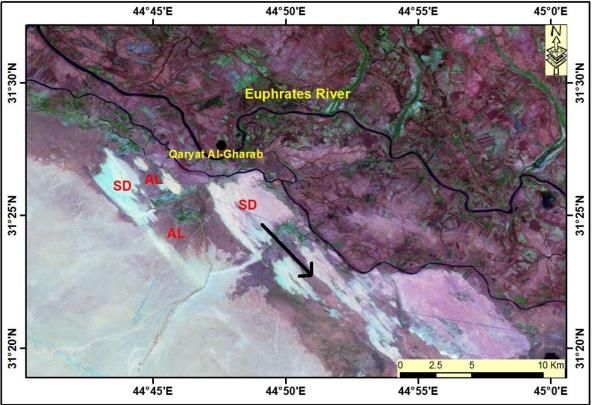
126                                                           Sissakian et al.

1. Introduction
Mesopotamia is a historical region in West Asia situated within the Tigris–
Euphrates river system. In modern days it is roughly corresponding to most of Iraq,
Kuwait, parts of Northern Saudi Arabia, the eastern parts of Syria, Southeastern
Turkey, and regions along the Turkish– Syrian and Iran – Iraq borders (Collon, 2011)
(Figure 1). Mesopotamia means "(Land) between two rivers" in ancient Greek. The
oldest known occurrence of the name Mesopotamia dates to the 4th century BCE,
when it was used to designate the land east of the Euphrates in north Syria
(Finkelstein, 1962). In modern times, it has been more generally applied to all the
lands between the Euphrates and the Tigris, thereby incorporating not only parts of
Syria but also almost all of Iraq and southeastern Turkey (Foster and Polinger Foster,
2009). The neighboring steppes to the west of the Euphrates and the western part of
the Zagros Mountains are also often included under the wider term Mesopotamia
(Canard, 2011, Wilkinson, 2000 and Matthews, 2003). A further distinction is
usually made between Upper or Northern Mesopotamia and Lower or Southern
Mesopotamia (Miquel et al., 2011). Upper Mesopotamia, also known as the Jazira,
is the area between the Euphrates and the Tigris from their sources down to Baghdad
(Canard, 2011). Lower Mesopotamia is the area from Baghdad to the Persian Gulf
(Miquel, 2011). In modern scientific usage, the term Mesopotamia often has a
chronological connotation also. In modern Western historiography of the region,
the term "Mesopotamia" is usually used to designate the area from the beginning of
time, until the Muslim conquest in the 630s, with the Arabic names Iraq and Jazira
being used to describe the region after that event (Foster and Polinger Foster, 2009
and Bahrani, 1998).

Desertification and Salinization of the Mesopotamian Plain:                        127
A Critical Review

Figure 1: Geographical extension of Mesopotamia (Approximately limited by
    the dashed blue line including the Mesopotamian Plain) showing the
    Mesopotamian Plain (Approximately limited by the dashed red line).
           (Internet data, 2013) (Limits are added by the authors).
The Mesopotamian plain; however, is different geographically, geologically and
historically from Mesopotamia. The Mesopotamian plain represents part of
Mesopotamia, and nowadays it represents the existing plain between the Tigris and
Euphrates rivers, which is limited to south of Al-Fatha gorge in the north, and the
alluvial plains along the Iraqi – Iranian borders in the east. From the west, it is
limited by wadi Al-Tharthar and the eastern limits of the Western Desert; then it
extends to the northern limits of the Southern Desert (almost parallel to the
Euphrates River); forming the southern limits of the plain. From the southeast, it is
limited by the upper reaches of the Arabian Gulf (Figure 1).
The majority of the published information about Mesopotamia is related and
concerned with the historical data about the different civilizations that rose here;
since it was the cradle of the civilizations. Therefore, the available published data
is related to the late Holocene Period (less than 10,000 years). The majority of the
available data is related to irrigation canals, changing of the river courses, dams’
construction and flood control works.
The age of the Mesopotamian plain dates back to the Pleistocene (2.558 Ma), and
because the alluvial sediments of the plain are not of concern to oil explorations;
therefore, very limited data is available from the drilled oil wells in this plain. The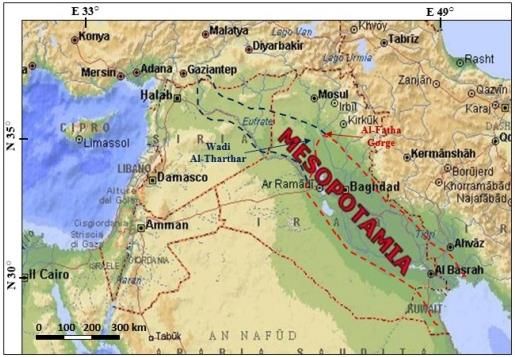
128                                                           Sissakian et al.

same is true for the water wells; since the water wells very rarely encounter the
Pleistocene sediments. Moreover, there is a large similarity between the alluvial
sediments of the plain and the underlying Pre-Quaternary sediments (Yacoub, 2011);
especially, when the Bai Hassan Formation underlies the Mesopotamian plain
sediments.

2. Desertification of the Mesopotamian Plain
Quaternary sediments cover the whole plain (Figure 2), which suffers from high
rate of desertification as the creeping sand dunes and sand sheets are increasing in
their coverage areas.

2.1     Type of the Sediments
The Mesopotamia plain is totally covered by Quaternary sediments (Figure 2); the
older formations below these sediments are Injana, Mukdadiya, Bai Hassan, and
Dibdibba (Yacoub, 2011 and Sissakian and Fouad, 2012). The beds of all pre-
Quaternary formations show dip towards the basin from all peripheral parts;
however, some of the formations are exposed along the periphery of the plain
(Figure 2). The exposed rocks at the western and southern sides of the plain have a
gentle dip, while those exposed in Makhoul and Hemren Mountains, at northeast
and east, have steep dip toward the plain. Both Makhoul and Hemren anticlines have
axial trend of NW – SE. Hemren Mountain continues further along the eastern
border of Iraq to the area east of Amara city. The presence of Quaternary sediments
surrounded by pre-Quaternary rocks in the plain has contributed in the development
of sand dunes at different parts of the plain, besides, other factors have contributed
in the development and increasing of the coverage areas of the sand dunes.

2.2      Aeolian Sediments
The Aeolian sediments of different forms and types are characteristics of the arid
and semi-arid climatic conditions, which prevailed during Holocene Epoch in the
Mesopotamian plain and near surrounding. Their influences have increased,
especially during the Late Holocene, and recently became more effective (Sissakian
et al., 2013 and Al-Quraishi, 2013). The Aeolian sediments cover wide areas in the
Mesopotamian plain in the form of large sand dunes fields, thin discontinuous sand
sheet, and Nebkhas (Figure 3). In the Mesopotamia plain, sand dune fields are
developed along the eastern, northern, southwestern and the central part of the plain
(Figures 2 and 4). They are different in grain size, mineral constituent and source of
sediments. The thickness of the sand sheets does not exceed one meter with wide
extensions, whereas, the thickness of Barchan fields reaches 5m, and exceptionally
may attain (25 – 30)m in southwest of Samawa. The sand dunes had accumulated
during the late Holocene, or may be slightly earlier. Two stages of Aeolian
sediments’ development can be observed:
    1. The relatively old stage represented by the fixed sand dunes. These are
         coated by thin mantle of soil with small native vegetation which helped in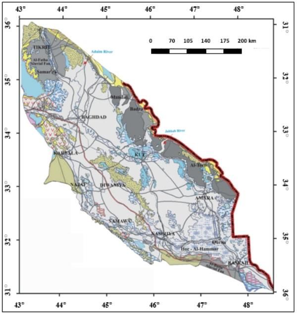
Desertification and Salinization of the Mesopotamian Plain:                     129
A Critical Review

        fixing the dunes and
     2. The young stage where the dunes are still active. The sediments of the
        marginal parts; however, seem relatively older than those deposited in the
        central part of the plain (Yacoub, 2011).
The orientation of the sand dune fields is usually NW – SE coinciding with the trend
of the basin, which is bounded by high topographic terrains having the same
directions. The windward slopes of individual Barchans dune indicate that the
prevailing wind is N – S and NW – SE. The influences of the wind activities have
intensively increased during the last four decades, due to increased drought
environmental conditions, less precipitation and higher temperatures (Sissakian et
al., 2013). The sediments of the main sand dune fields are described briefly
hereinafter.
Sand dunes along the eastern margin: These are represented in the form of large
fields along the Iraqi – Iranian borders west of Ali Al-Gharbi town in Al-Teeb
and Chlat (Figures 2 and 4). They consist of fine to medium grained sand, with
small amounts of silt and clay fraction.
The dunes are composed mainly of quartz, chert, limestone, and small amounts of
heavy minerals; which are derived from the exposed Miocene and Pliocene rocks
in Hemren Range and Quaternary sediments.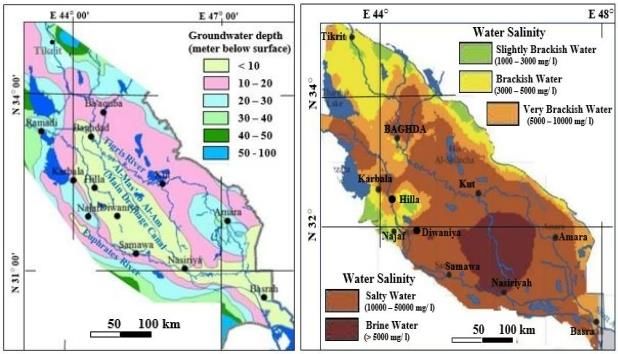
130                                                   Sissakian et al.

 Figure 2: Geological map of the Mesopotamian Plain (After Yacoub, 2011).
Desertification and Salinization of the Mesopotamian Plain: 131
A Critical Review
Figure 3: Typical Nebkha developed due to sand accumulation around shrubs
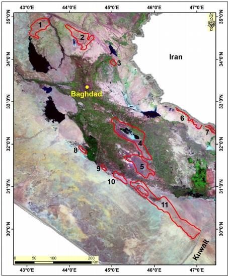
Figure 4: Satellite image showing the main sand dune fields in the
Mesopotamian Plain.
Sand dunes: 1= Baiji, 2= Shari, 3= Baladrooz, 4= Hilla - Diwaniya, 5=
Diwaniya – Samawa, 6= Al-Teeb, 7= Chlat, 8, 9 and 10 = Abu Jir active
Zone Depression, and 11= Al-Slaibat – Al-Batin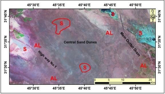
132                                                             Sissakian et al.

Sand dunes along the northern margin: Three large sand dune fields are
developed along the northern margin of the Mesopotamian plain, these are:
     1. Baiji,
     2. Shari, and
     3. Baladrooz (Figures 2 and 4).
They generally consist of fine to medium grained sand. The sand grains are
composed mainly of quartz, chert, limestone, and few amount of heavy minerals;
the main source of these sediments is the exposed Miocene and Pliocene rocks in
Hemren Range and Quaternary sediments. For Baiji sand dunes, only the part which
is within the Mesopotamian Plain is considered in this study and presented in Figure
4.
Sand dunes of the southwestern margin: These sand dunes are developed mainly
along the depression located within Abu Jir active fault zone (Figures 2 and 4). They
consist mainly of fine to medium grained sand, with few coarse admixtures, and
subordinate amount of clay and silt fraction. The sand is composed essentially of
quartz, carbonate and less amount of feldspar, and rock fragments. The percentage
of quartz grains often exceeds 50% and the carbonates reach up to 27.5%, in
Samawa area (Yacoub, 2011). The main source of the sand dunes is the Late
Neogene and Pleistocene rocks, which are exposed in the Western and Southern
Deserts, and along Tar Al-Najaf and Tar Al-Sayed, besides the local Quaternary
sediments.
Sand dunes of the central part: The sand dunes of the central part are developed
between the Tigris and Euphrates Rivers (Figures 2 and 4), overlying the abandoned
flood plain sediments. They are associated with dense anthropogenic sediments
littered with pottery and brick fragments. The sediments of this field consist
essentially of silt and clay in form of very tinny clay balls; locally rich with mud
flakes and mollusk shell fragments, which are deflated from the surrounding dry
marshes and lake sediments. The main sources of these sediments are the flood plain
sediments of the Tigris and Euphrates Rivers and their related branches, in addition
to the ancient irrigation canals.
Beside the sand dunes, sand sheets and Nebkhas form also part of the Aeolian
sediments in the Mesopotamian Plain. Sand sheets are usually developed in between
sand dune fields and/ or south wards from the active sand dunes where they are
spread due to wind action. The thickness of the sand sheets ranges from less than
one meter up to 1m and very rarely exceeds that. Some small rock fragments and/
or pebbles, not more than 1 cm in size, can be seen in the sand sheets. Their main
constituents depend on the original sand dunes from where they are originated. The
presence of sand sheets covering vast areas is good indication of desertification.
Nebkhas are also type of Aeolian sediments (Langford, 2000). A Nebkha is a sand
dune that forms around vegetation with thickest part being in the wind main
direction. It is an aeolian landform, i.e. a structure built and shaped by the action of
wind. The development of Nebkhas within sand dune fields and/ or sand sheets is
very common.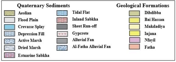
Desertification and Salinization of the Mesopotamian Plain:                       133
A Critical Review

3. Salinization of the Mesopotamian Plain
Salinization is the process by means of which a non-saline soil becomes saline, as
by the irrigation of land with brackish water (Oosterbaan, 1988). During last
decades, salinization became one of the major problems in the Mesopotamian plain
which suffers from increasing salinization. Problems with salinization are most
commonly associated with excessive water application, rather than with too little.
All irrigation water contains dissolved salts which are acquired as it passes over and
through the land. Rain water also contains some salts, but these are generally in very
low concentration in the water itself. However, the used irrigation water is highly
contaminated from two main sources:1) Al-Tharthar Depression (lake), and 2) Main
Outfall Drain (Al-Mus’sab Al-Am) which collects the drainage water from all the
drains in central and southern parts of Iraq. In the Mesopotamian plain, miss-
management of water resources and the prevalence of primitive irrigation systems
and methods of irrigation are the main reasons for increasing the salinization of the
soil (Figure 5). Before construction of the dams in Turkey, Syria, Iran and Iraq, the
huge amounts of running water during floods in the rivers were washing out the
accumulated salts in the agricultural lands and supplying new silty clay cover;
therefore, salinization was less.

    Figure 5: Satellite image showing salinized soils (the light pink colored
                         polygons) along the Tigris River.
134 Sissakian et al.
4. Discussion
The desertification and salinization in the Mesopotamian Plain is discussed
hereinafter.
4.1 Desertification
Desertification is a type of land degradation in which a relatively dry area of land
becomes a desert, typically losing its bodies of water as well as vegetation and
wildlife (Geist, 2005). In the Mesopotamian plain, the desertification is a serious
problem which is increasing rapidly and covering large areas; among them are
agricultural lands (Figure 6). In order to indicate the change in coverage areas of the
sand dunes within the Mesopotamian Plain, the coverage areas of each main dune
was calculated from the geological map (Sissakian and Fouad, 2012) (Figure 2) and
compared with the current coverage area (Figure 6). The results are presented in
Table 1. The indicated years in Table 1, refer to the year in which geological
mapping was performed at the areas under consideration. It is clear that the
periphery and coverage area of each sand dune has increased significantly. The
current periphery and coverage area of each sand dune were calculated from satellite
images, whereas the original periphery and coverage area of each dune (Figure 2)
were calculated through matching the geological maps with satellite images; after
being digitized at accuracy of 1:100,000 scale.
Figure 6: Satellite image of the Central Sand Dunes. AL means abandoned
agricultural lands, S means salinized soils (Sabkha). Note the special
embankments along the high way to stabilize the sand dunes. The two
polygons are depressions in which the salinization (Sabkha) increases.Desertification and Salinization of the Mesopotamian Plain: 135
A Critical Review
Figure 7: Satellite image of the sand dunes (SD) south west of Samawa city.
AL means abandoned agricultural lands, the arrow points to the creeping
direction of the dunes.136 Sissakian et al.
Table 1: Comparison between the peripheries and coverage areas of main sand
dunes in the Mesopotamian Plain
Year Name Periphery Area Remarks
2
(km) (km )
1974 Baiji 104 492 Only the part which is within the
2019 188 1159 Mesopotamian Plain
1977 Shari 154 1056
2019 244 1304
1983 Baladrooz 63.8 161
2019 84.2 174
1984 Central part of the 222 1127 On the geological map (Figure 2) these
2019 Mesopotamian Plain 252 1683 two main sand dune fields are
1982 Hor Al-Dalmaj 301 3014 combined together
2019 316 3057
1978 Abu Jir Sand Dunes 42 49
2019 No. 1 53 68.6 The small dunes are either neglected or
1978 Abu Jir Sand Dunes 22 23.3 combined together during digitization
2019 No. 2 40.2 71.9
1978 Abu Jir Sand Dunes 72.8 173
2019 No. 3 108 355
1979 Al-Slaibat – Al-Batin 386 1474
2019 464 3117
Including 214 km of
Al-Slaibat Depression
1980 Chlat 95 591
2019 117 659
1980 Al-Teeb 81 101
2019 85.4 177
The factors which causes the increase desertification; directly and / or indirectly in
the Mesopotamian plain are briefed hereinafter.Desertification and Salinization of the Mesopotamian Plain: 137
A Critical Review
4.1.1 Climate changes
The annual rainfall over the plain has been decreasing as a result of the global
climate change impacts; accordingly, the amount of surface water is decreasing
drastically. This is also leading to the decrease of the area of the agricultural lands,
since farmers are abandoning their lands (Figures 6 and 7). The continuous
abandonment of lands will in its turn increase the erosion capacity of the soil,
especially so as they are ploughed lands. As a final result new sand dunes will
develop increasing the creeping of dunes over the cultivated areas.
4.1.2 Abandoning of agricultural lands
Beside the above mentioned reason for abandoning of agricultural lands, many other
reasons also exist, these are:
i) The increase of salinity in surface water. This is due to the increase of
the salt concentration in the waters of the rivers. This is attributed to the
saline water supplied from Al-Tharthar reservoir to augment the Tigris
and Euphrates rivers flow during draught seasons.
ii) Unwise water management. This is leading to the increase of the salinity
in the surface water; accordingly, the salinity of the soil is also increasing
and the fertility is decreasing.
iii) Using for irrigation the drainage water from the Main Outfall Drain
(Figure 6) which runs in between the Tigris and Euphrates rivers from
west of Baghdad and pours out in the Arabian Gulf. This drainage water
is highly saline and its reuse for irrigation without mixing with good
quality water is increasing the salinity of the soil.
iv) Shallow Ground water level: The ground water level is rising
continuously as a result of excessive water application (Figure 8 Left);
which is mainly due to miss-management of both surface and
groundwater. At the same time this is also causing the increase of salinity
in ground water itself, (Figure 8 Right) which will make it not be suitable
for irrigation also. Social and community issues. Thousands of people
are migrating from rural areas to cities and especially to the Capital for
better living conditions and for better job opportunities.
v) Social and community issues. Thousands of people are migrating from
rural areas to cities and especially to the Capital for better living
conditions and for better job opportunities.138 Sissakian et al.
Figure 8: Left) Groundwater depth map, Right) Water Salinity map.
(Modified from Al-Jiburi and Al-Basrawi, 2015).
4.1.3 Haphazard Driving
In rural areas, the majority of roads are earth roads and unpaved, so when local
people drive their cars and other trucks on these roads, they cause the rise of heavy
dusts which damage the vegetative cover, likewise when they use their heavy
cultivation on the dry land they accelerate soil erosion and cause the degradation of
its structure as the coherence of the top soil is destroyed. Accordingly, the top soil
is easily weathered and changed to fine clayey particles developing new sand sheets
and/ or sand dunes.
4.1.4 Farming Practices
Many of the farmers are not familiar with the correct land management practices
and are ignorant of how to use their lands effectively. In many cases they essentially
clear the land of everything on top of one plot of land nutrients, desertification
becomes more and more of a reality for the cultivated areas. Moreover, the majority
of farmers use the fallow method of cultivation whereby they cultivate one half of
their lands in one year and leave the other half to be cultivated in the next year which
means large tracts of land remain barren with no vegetation cover and completely
dry especially during draught seasons. This will accelerate degradation of the soil
and accordingly accelerate desertification.Desertification and Salinization of the Mesopotamian Plain: 139
A Critical Review
4.2 Salinization
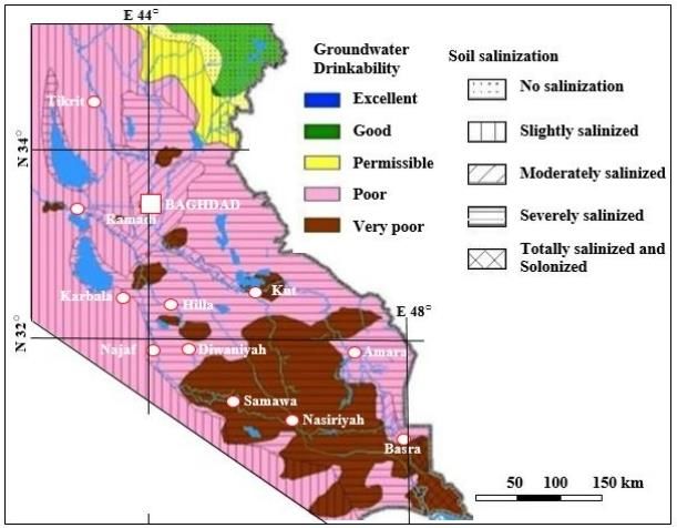
Salinization of soil is another main problem in the Mesopotamianp, it is mostly
accompanied with desertification, and both processes are considered to be forms of
soil degradation (Slavikova, 2019). Large parts of the plain are severely salinized
with many parts which are even totally salinized and with increasing salt content in
the groundwater (Figure 9).
Figure 9: Map od Drinkability of water and soil salinization (Modified from
Al-Jiburi and Al-Basrawi, 2015)
Some of the factors which increase salinization in the plain are mostly the same as
those which increase desertification such as climate change, unwise water
management, bad farming practices and abandonment of agricultural lands.
However, some other factors also play significant roles in increasing salinization of
the soil, these are:
i) The Mesopotamian plain is a closed basin which retards the free flow of
the groundwater into the Arabian Gulf. This is contributing to the
precipitation of the salts in the ground water.
ii) The construction of many storage dams on the rivers has decreased the
possibilities of flooding. Accordingly, there is no provision of new
supply of silt to the flood plains
iii) So, no more washing out of the accumulated salts is done.140 Sissakian et al. 5. Conclusions The following conclusions can be drawn from this study; Large rural and agricultural lands of the Mesopotamia pain are affected by desertification; especially major parts of the cultivated area. This is causing one of the most serious desertification problems in the whole of the Mesopotamian plain. Many factors play significant roles in this desertification process, which are: climate change, abandoning of the agricultural land for various reasons, unwise water and land management, and haphazard cars and trucks driving. Salinization of soil in the Mesopotamian plain is also another significant problem which is increasing continuously due to a multitude of reasons which are also leading to cause desertification. However, the main reason is being the use of the storage water of Al-Tharthar Depression (lake) to overcome water shortage in the Tigris and Euphrates rivers during draught seasons. The fresh water which is diverted to Al- Tharthar Depression for storage there becomes polluted by the dissolved salts from the exposed gypsum beds in the depression, and when it is returned back to both rivers it is contaminated with salts, and it is used for irrigation by the farmers in their very primitive irrigation methods, then will cause the salts to be precipitated in the soil after the evaporation of water. Using the water of the Main Outfall Drain (Al-Mas’sab Al-Am) for irrigation has also contributed to the increase of salinity in the soil. Moreover, the shallow saline groundwater which migrate upwards by capillary action is causing and increased salinity of the soils of the cultivated lands causing its deterioration. Acknowledgements The authors express their sincere thanks to Mohammed Al-Azzawi (Iraq Geological Survey, Baghdad) for supplying the satellite images and to Mr. Maher Zaini (Iraq Geological Survey, Baghdad) for conducting some of the enclosed figures.
Desertification and Salinization of the Mesopotamian Plain:                     141
A Critical Review

References
[1] Al-Quraishi, A.M.F. (2013). Sand dunes monitoring using remote sensing and
     GIS techniques for some sites in Iraq. Proceedings of SPIE - The International
     Society for Optical Engineering, February 2013.
[2] Al-Jiburi, H.K. and Al-Basrawi, N. H. (2015). Hydrogeology Map of Iraq,
     scale 1: 1,000,000, 2nd edition. Iraqi Bulletin of Geology and Mining, Vol. 11
     No. 1, pp. 27 – 43.
[3] Bahrani, Z. (1998). Conjuring Mesopotamia: Imaginative Geography a World
     Past. In: Meskell, L., Archaeology under Fire: Nationalism, Politics and
     Heritage in the Eastern Mediterranean and Middle East, London: Routledge,
     pp. 159–174. ISBN 978-0-41519655-0.
[4] Canard, M. (2011). "Al-ḎJazīra, Ḏjazīrat Aḳūr or Iḳlīm Aḳūr". In: Bearman,
     P., Bianquis, Th., Bosworth, C.E., van Donzel, E. and Heinrichs, W.P.
     Encyclopedia of Islam, 2nd edition. Leiden: Brill Online, OCLC 624382576.
[5] Collon, D. (2011). Mesopotamia. BBC, Ancient History in Depth.
     http://www.bbc.co.uk/history/ancient/cultures/mesopotamia_gallery.shtml.
[6] Finkelstein, J.J. (1962). "Mesopotamia", Journal of Near Eastern Studies, 21
     (2), pp. 73 – 92. doi:10.1086/371676, JSTOR 543884.
[7] Foster, B. R. and Polinger Foster, K. (2009). Civilizations of Ancient Iraq,
     Princeton: Princeton University Press. ISBN 978-0-691-13722-3.
[8] Geist, H. (2005). The Causes and Progression of Desertification. Ashgate, p.
     258,https://books.google.iq/books/about/The_Causes_and_Progression_of_D
     esertific.html?id =acbWdynlU3cC&redir_esc=y.
[9] Internet Data (2013). Mesopotamia Research Project/ WebQuest
     http://cybermesowebquest.blogspot.com            /2013/10/       mesopotamia-
     researchprojectwebquest.html.
[10] Langford, R. P. (2000). Nabkha (coppice dune) fields of south-central New
     Mexico, USA. Journal of Arid Environments, Vol. 46, No. 1, pp. 25 – 41.
[11] Matthews, R. (2003). The Archaeology of Mesopotamia. Theories and
     Approaches, Approaching the past, Milton Square: Routledge, ISBN 0-415-
     25317-9.
[12] Miquel, A., Brice, W.C., Sourdel, D., Aubin, J., Holt, P.M., Kelidar, A., Blanc,
     H., MacKenzie, D.N. and Pellat, Ch. (2011). "ʿIrāḳ". In: Bearman, P., Bianquis,
     Th., Bosworth, C.E., van Donzel, E., Heinrichs, W.P., Encyclopedia of Islam,
     2nd edit. Leiden: Brill Online, OCLC 624382576.
[13] Oosterbaan, R.J. (1988). Effectiveness and Social/ Environmental Impacts of
     Irrigation Projects: A Critical Review. In: ILRI Annual Report 1988, pp. 18-
     34, International Institute for Land Reclamation and Improvement,
     Wageningen, The Netherlands.
[14] Sissakian, V.K. and Fouad, S.F. (2012). Geological Map of Iraq, scale
     1:1,000,000, 4th edition. Iraq Geological Survey Publications, Baghdad, Iraq.
     www.iasj.net/iasj?func= fulltext&aId =99666
142 Sissakian et al.
[15] Sissakian, V.K., Al-Ansari, N. and Knutsson, S. (2013). Sand and dust storm
events in Iraq. Natural Science, Vol. 5, No. 10, pp. 1084 – 1094.
[16] Slavikova, S.P. (2019). Soil degradation. Internet data.
https://greentumble.com/causes-andeffects-of-desertification/.
[17] Yacoub, S.Y. (2011). Stratigraphy of the Mesopotamia Plain. Iraqi Bulletin of
Geology and Mining, Special Issue No. 4, pp. 47 – 82.You can also read