Water Vole Survey Volunteer Handbook - Greater Manchester Ecology Unit May 2018 - Greater Manchester ...
←
→
Page content transcription
If your browser does not render page correctly, please read the page content below
Water Vole Survey
    Volunteer Handbook
    Greater Manchester Ecology Unit
                          May 2018

1
Water Vole Survey
Volunteer
Handbook
Carbon Landscape
Citizen Science Project
Contact us

Please contact the Greater Manchester Ecology Unit (GMEU) if you have any questions
with regard to this survey handbook.

      Greater Manchester Ecology Unit
      Tameside Council Offices
      Clarence Arcade
      Stamford Street
      Ashton-under-Lyne
      OL6 7PT
      0161 342 4121
      carbonlandscape@gmwildlife.org.uk

Document version: 14-05-2018
Cover photo Peter Trimming cc-by-sa

2
Contents
Introduction..................................................................................................................................................................................................4
Survey Preparations .............................................................................................................................................................................. 5
One kilometre square and site selection ..................................................................................................................... 5
Submitting your survey data ................................................................................................................................................... 5
Land owner permissions ............................................................................................................................................................. 6
Survey timings ...................................................................................................................................................................................... 6
General equipment list .................................................................................................................................................................7
Health and safety .............................................................................................................................................................................. 8
Biosecurity ............................................................................................................................................................................................... 9
Water Vole Survey ................................................................................................................................................................................ 10
Background .......................................................................................................................................................................................... 10
Useful/essential equipment ................................................................................................................................................... 10
Planning your survey and establishing new survey transects .................................................................... 11
Additional Safety Considerations ....................................................................................................................................... 12
The habitat survey............................................................................................................................................................................14
Survey methodology .....................................................................................................................................................................14
Identification resources ..............................................................................................................................................................15
Additional confusion signs and species .......................................................................................................................15
Additional Records ........................................................................................................................................................................ 16
Feedback ................................................................................................................................................................................................ 16
Appendices ................................................................................................................................................................................................. 17
Grid references ................................................................................................................................................................................... 17
3Introduction Thank you for volunteering to take part in the Carbon Landscape’s Citizen Science Project to monitor key species through structured surveillance. The project’s boundary, [view map: https://gmwildlife.org.uk/mapapp/?project=carbonlandscape] encloses the core of the Great Manchester Wetlands Nature Improvement Area (NIA) which supports a host of European and UK protected species, as well as UK Biodiversity Priority Species, all dependent on the mossland and wetland habitats which the project will enhance and restore. The project will build on the existing survey work being undertaken and will also recruit and train new recorders, our Citizen Scientists. It aims to significantly increase survey coverage of target species, including water vole, across the key habitat restoration areas, and the wider Carbon Landscape. The surveys have been designed with the help of specialist county and vice-county recorders who between them have a wealth of experience in species monitoring in the North-west of England. The survey methods are structured and repeatable allowing valuable data to be collected, not only during the three year lifetime of the project, but well into the future. Biological datasets are of most value when collected over a long time span. Monitoring the abundance and distribution of the target species is an important mechanism for measuring the success of the habitat works on the ground and changes to the landscape over time. The robust data collected from the project’s surveys and the subsequent survey effort will be used to monitor sites over time, allowing the success of habitat management works to be assessed and to influence future sustainable management. This will be of particular benefit to those owning or managing land within the Carbon Landscape, whilst providing ecologists and conservationists with biological data that can be analysed at landscape scale. This project will provide important insights into the factors influencing the abundance and distribution of some of our key species and most importantly, will be used to support future species conservation work. 4
Your contribution as a Citizen Scientist to the Carbon Landscape Project is greatly valued.

Survey Preparations
One kilometre square and site selection
The Carbon Landscape’s Citizen Science Project survey unit is the 1km square and we
aim, with your help, to survey as many of these as possible within the Carbon Landscape
area by the end of June 2020. This will ensure the data collected is statistically robust
and enable species distribution to be mapped at a landscape scale.

We have developed an online data portal which enables recorders to request 1km survey
squares and view those already allocated, see gmwildlife.org.uk/carbon_landscape/
survey_squares. Co-ordinating volunteers’ survey effort will enable a large biological
dataset to be compiled and ensure coverage is as comprehensive as possible, giving us a
clear picture of the distribution of water vole at landscape scale.

Submitting your survey data
When carrying out your survey, please enter your data onto the field survey forms
provided. Your data should ideally be submitted to GMEU as soon as possible after each
survey visit. We are currently developing an online data entry portal and will inform you
once this is live. However, as an interim measure survey forms should be scanned and
emailed to carbonlandscape@gmwildlife.org.uk or posted to GMEU. If sending by post,
please ensure you retain a copy of your data as a backup.

5
Land owner permissions
Landowners’ permission for access onto private land where there are no public rights of
way must be obtained. The Carbon Landscape Programme team are compiling a
database of landowners and requesting access to their land. If you are unsure if you have
permission to walk on land please check with GMEU before carrying out your surveys.
Please pass on to us any information you obtain on landowners and their contact details
as these will be added to the database.

You will be issued with a letter (also available to download from our website
gmwildlife.org.uk/carbon_landscape/) which briefly explains that you require access to
carry out ecological surveys and advising that you request the landowner to contact
GMEU should they require additional information. We rely very much on the good will of
farmers and landowners and are willing to share survey data with them if they are
interested in knowing which species occur on their land with a view to sympathetically
managing the habitats under their stewardship.

Survey timings
The Carbon Landscape Project surveys should be carried out at the specified time of year
which varies depending on the target species or taxonomic group. The surveys have been
designed so that they can be completed by one or a number of different volunteers over
a year. The survey methodologies and dates are based on current national surveys which
will allow the direct comparison of the results with national data and trends.

6
General equipment list
Some of the surveys require specialist equipment, details of which can be found in the
individual survey methodologies, However, there are a number of items that should be
taken on every survey: -
Survey route map
Field survey form
Clipboard, recording form and pencil
Note book
Waterproof clothing
Sturdy walking boots
First aid kit
Food and drink (if required)
Hat and suntan lotion (strongly recommended from April to September, even
during cloudy conditions)
Whistle
Camera (may be useful)
Mobile phone, in case of emergency (do not rely on smart phones for navigation)
Warm clothing (if required)
Insect repellent (if required)
Optional equipment
Global positioning system (GPS), available to loan from GMEU
Compass
7Health and safety
We want you to remain safe. Before any survey is attempted, the route should be pre
walked and any potential risk assessed. Listed below are a wide variety of general hazards
that you might encounter when working in the field along with precautions to reduce
the risks: -
Example risk Example precautions
Undulating / rough terrain and steep slopes Select appropriate footpath / route. Wear appropriate footwear with good soles
and ankle support.
Weather Ensure you are aware of the forecast prior to your work. This is of particular
importance in the winter or when visiting remote areas.
Dense vegetation Hazards such as holes, burrows, tree stumps or fencing may be obscured. Work
with care in such conditions.
Protruding stems Take care when bending to survey vegetation to avoid injuries to eyes.
Streams and rivers Cross streams or rivers only by footbridges or other purposely built structures.
Avoid any structures that appear damaged or poorly maintained.
Poorly maintained footpaths, stiles, etc. Avoid these if possible and report to the appropriate agencies.
Lone working Conduct survey work in pairs whenever possible
Secluded sites If in doubt err on the side of caution and do not walk alone. Inform another
person of where you are going, your route and estimated time of return and
arrange for them to contact the authorities and GMEU if you do not contact
them to say you have arrived back safely.
'People' Hazards - might include poachers, Exercise good judgement and assess the situation. Avoid confrontation and
strangers in isolated sites, irate owner/occupier, withdraw if threatened. Record any incident and inform the appropriate
people with dangerous dogs, etc. authorities and GMEU. Carry a mobile phone. Operate lone working system and
if in doubt do not work alone.
Farm animals Heed any warning signage and avoid entering fields containing dangerous
livestock.
People with firearms If shooting is legal make yourself known audibly and visibly. If illegal, withdraw
and report to the authorities and GMEU.
Railways NO fieldwork on active railways.
Hypothermia Wear appropriate warm and waterproof clothing. Carry extra clothing and high
energy food (e.g. chocolate).
8Biosecurity In the wake of the recent ash die back emergency, the Forestry Commission have updated their biosecurity guidance and produced a 13 page booklet on the subject. It is recommended that this is downloaded and read at http://www.forestry.gov.uk/pdf/FC_Biosecurity_Guidance.pdf/$file/FC_Biosecurity_Guidan ce.pdf. For low risk biosecurity control, ensure that footwear is clean prior to the visit (visually free from loose soil and plant debris). If necessary, brush or wash in soapy water before your visit. Keep vehicular access to a minimum, where practicable, keep to established hard tracks. Clean accumulated mud from vehicles. Observe signage at sites and follow any site specific biosecurity instructions. Where a damaging tree pest is known or suspected to be present and there is a risk of spreading the pest further, a higher level of biosecurity control will be needed. Please refer to the above document. Higher level controls will be required if the site is under animal health control, for example foot and mouth disease. 9
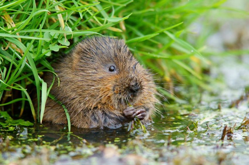
Water Vole Survey
Background
Nationally, the populations of Water Voles have declined dramatically, initially as a result
of degradation and loss of habitat and subsequently due to the spread of American Mink.
Water voles are protected under Section 9 of the Wildlife and Countryside Act 1981 (as
amended) and it is important that this survey is carried out without causing disturbance
to any water voles. Please take great care to avoid damage to banks and when searching
through vegetation.
The survey is based on the People’s Trust for Endangered Species National Water Vole
Monitoring Programme (NWVMP) survey guidelines (2015). Collecting records in this way
will enable your survey results to be utilised by the National Monitoring Programme and
locally, contributing valuable information for the Carbon Landscape Programme.
Useful/essential equipment
Binoculars
Walking pole / stick
Gardening gloves
GPS or phone with a grid reference location app (accuracy of 10m) e.g. GPS Status
& Toolbox (Android) or GridPoint GB (iOS)
A camera (particularly one which can take close up photos)
Ruler (for scale)
10Planning your survey and establishing new survey transects A map showing your allocated 1km square will be provided. Use this, in conjunction with a site visit to plan your survey transect. Aerial photographs may also be helpful in planning your route before you go to the site. Typical lowland habitats for water voles include: grasslands (both improved grasslands used for grazing livestock and semi- natural grasslands), arable farmland, mires, reed beds and lowland heathland. Water voles generally prefer slow flowing, meandering rivers and streams or ditches, canals or pools with plenty of tall and lush vegetation. The banks need to be suitable for making burrows. The survey should be conducted from public rights of way whenever this is possible. Where access to private land is required, please refer to the earlier section on landowner permissions. The survey will be carried out on a single visit between April and September (May is the optimal month) along one bank of a waterway (a 500 metre stretch is ideal). If the site does not contain a 500m stretch of waterway, shorter lengths (in 100m denominations) can be surveyed. Prior to the recording survey, a transect needs to be set up and a basic habitat survey carried out. This should be carried out on a separate visit during April in order to ensure the area is suitable to survey and to assess any specific site risks. The same survey transects will be used for all subsequent surveys (unless there is a compelling reason to change them). An 8 figure grid reference is recorded at the start of each 100m section. The final grid reference at the end of the last section is recorded. Accurate grid references, together with photographs and / or notes of features will help to identify the start of each section. Storing the route in a GPS as you set it up, will save time on future visits and ensure accuracy when carrying out the surveys. 11
Figure 1 – 5 x 100m sections along the south bank
                                                              of a watercourse

Additional Safety Considerations
Carrying out this survey requires access to the edge of waterbodies and although the
survey should be carried out without entering the water, there are specific hazards
associated with working close to water. Please ensure that you do not put yourself at risk.

In addition to the earlier generic health and safety advice please assess the risks which
are specific to your own survey site including the access route to the site. An ideal survey
area would have good access and good paths close to the edge of the water with a clear
view of the bank and shallow, slow flowing or standing water; however, some sites may
not have all of these positive attributes. If you are not happy that you can survey an area
without putting yourself or others at risk, do not carry out the survey. Please consider the
following specific hazards and adopt adequate control measures to prevent harm from
the following: -

1. If waterbodies are fast flowing / in flood, falling into fast flowing water can be very
     dangerous. This is not suitable water vole habitat and should not be surveyed. If
     encountered whilst accessing the survey area, always remain a safe distance away
     from this type of water and walk on safe paths / surfaces. Never stand in fast flowing
     water, even if it is shallow. Avoid surveying during flood conditions.
2. If waterbodies are deep, falling in has the potential to be very serious. Ensure that
     there is a safe surface to stand on next to the water.

12
3. The bank can be hazardous if the surface is slippery, has roots / trip hazards, is
unstable / undercut and could collapse or if dense vegetation obscures the edges.
Avoid hazardous sections by ‘scalloping’ the bank (see Figure 2 below) and viewing
from areas which are suitable. A walking pole / stick can be used to look through
dense vegetation. Protective gloves e.g. gardening gloves may be useful when
checking through vegetation. Binoculars can be used to observe areas which are
difficult to access. Stand still on firm ground whilst looking through binoculars.
Figure 2 - Scalloping around inaccessible or
unsafe areas of the bank
4. The beds of watercourses can be extremely slippery and waterbodies may contain a
deep layer of mud on the bottom. Carry out the survey from the bank.
5. Weil’s disease and other infections are potential hazards around waterbodies. Cover all
cuts and broken skin with waterproof plasters and adopt good hygiene (hand
washing and use of hand gel). For more information about Weil’s disease, refer to the
Health and Safety Executive website www.hse.gov.uk/pubns/indg84.pdf
13The habitat survey
This needs to be carried out before the water vole survey and can be conducted as the
transect route is set up in April. The vegetation needs to have enough of the new season’s
growth for the surveyor to confidently identify the broad types of habitats which are
present. Walk the survey route and for each 100m section, note the waterbody type and
the main vegetation types which are present for the area within 2m of the bank on
survey side of the water course. Habitat descriptions are available on the Habitat Survey
Form. Please estimate the % coverage of these in each 100m transect section.
Survey methodology
One survey visit should be conducted between April and September at any time of
the day and should take approximately 45 minutes to one hour to complete.
However, May is the optimal survey month as this will allow population data to be
collected prior to the start of the breeding season and permit comparison
between sites across the Carbon Landscape. In addition, as the season progresses
and bankside vegetation grows, surveying becomes more difficult.
Surveys should not be conducted during times of flooding or heavy rain. Please
wait at least two days after the water levels have subsided to allow field signs to
accumulate and be visible.
Walk as close to the water’s edge as possible (while remaining safe). Carry out a
continuous search for field signs (latrines, feeding signs, burrows/nests) and water
vole sightings along each of the transect sections. Record the number of these,
together with the grid reference on the survey sheet.
If the bankside vegetation is particularly dense, such that a continuous metre by
metre search is not appropriate, “scallop” the bank (Figure 2 above). Aim to go to
the water’s edge at 2m intervals and sample up to 0.5m each side of the sampling
point.
Please record mink or otter sightings. If mink scat or otter spraint are seen (and you
are confident with the identification), please record these on the survey form.
14 Where possible, please take photographs of any water vole, mink and otter field
signs (using a ruler for scale).
Additional surveys – if you wish to carry out more than one survey during the
season please request an additional 1km survey square. This will help to maximise
coverage across the Carbon Landscape.
Identification resources
The People’s Trust for Endangered Species has produced an excellent guide to signs of
water voles and other river bank species. This is available at https://ptes.org/wp-
content/uploads/2015/03/Your-guide-to-looking-for-signs-of-water-voles-and-other-
riverbank-species.pdf. In addition to the field signs of water vole, otter and mink, this
guide shows some of the confusion species and their signs.
Additional confusion signs and species
Field voles, and other small mammals also cut pieces of vegetation (particularly grasses,
sedges & rushes), in a similar manner to water voles; however, vegetation in field vole piles
will be cut at about 2-5cm long whereas water vole tend to cut longer sections. Water
voles eat a wider variety of different wetland vegetation and will tackle thicker and
woodier species (such as willow stems). Field vole burrows are usually no more than 2
fingers in size; whereas, you can usually fit 3-4 fingers into a water vole burrow. Field vole
droppings are the same colour and shape as water vole droppings but much smaller.
Field vole droppings are similar in size to a grain of rice. Adult water vole droppings are
slightly bigger than ‘tic tac’ size.
Brown rats commonly live along the water’s edge and their burrows are similar in size
and shape. However, rats leave excavated spoil piles outside the entrance and usually
have bare, well-worn pathways (rat runs) leading up to them. Rat droppings are usually
slightly larger than water vole; they have a pointed end and foul smell.
15Additional Records Any additional biological records of other species (including records of brown rat) that are observed whilst carrying out the survey will be very welcome and these can be submitted together with the survey results. Feedback Once you have carried out the surveys, we would welcome your feedback on this survey manual and the accompanying recording forms. Please email carbonlandscape@ gmwildlife.org.uk with your suggestions for clarifying / improving the survey instructions and whether it would be beneficial to include additional information. 16
Appendices
Grid references
GPS often display grid references of 10 figures which would imply an accuracy of 1m 2.
Most GPS will give a ± accuracy number. If this number is 10m or less, an 8 figure grid
reference can be recorded to reduce this false accuracy (i.e. a grid reference which has an
accuracy of 10m rather than 1m).

If you have a 10 figure grid reference (accurate to 1m) and you want to obscure it to an 8
figure grid reference (accurate to 10m), the following example shows you how to remove
the final digits from the easting and northing to reduce the precision.

GPS Reading SD 58315 03315 → Recorded Grid Reference SD 5831 0331

If you have an 8 figure grid reference (accurate to 10m) and you want to obscure it to a
six figure grid reference (accurate to 100m), the following example shows you how to
remove the final digit from the easting and northing.

8 Figure Grid Reference SD 5831 0331 → 6 Figure Grid Reference SD 583 033

Be careful – never round the numbers up when
reducing the accuracy of a grid reference as it
would move your record to an adjacent grid square
north-east of the actual location.

The screenshot here shows different levels of
precision for the same marker location on the map.
Click this link and then click on the marker to try
this yourself - https://gmwildlife.org.uk/mapapp/?
path=SD6254500455

                                     END OF INFORMATION

17
You can also read