Kiawah Island Utility Directionally Drills Water Main under Wetlands and Kiawah River
←
→
Page content transcription
If your browser does not render page correctly, please read the page content below
North American Society for Trenchless Technology (NASTT)
                                 NASTT’s 2017 No-Dig Show

                                               Washington, D.C.
                                               April 9-12, 2017

                                                    TA-T2-01

     Kiawah Island Utility Directionally Drills Water Main under Wetlands
                               and Kiawah River
Mark Yodice, Thomas & Hutton Engineering Co., Mt. Pleasant, SC
Jim Williams, Mears Group, Inc., Houston, TX
Becky Dennis, Kiawah Island Utility, Inc., Kiawah Island, SC
Rachel Maupin, Underground Solutions, Inc., Poway, CA

1.       ABSTRACT

The existing Kiawah Island Utility (KIU) water system consists of one 16-inch ductile iron main installed in the late
1970s, connecting Kiawah Island to potable water provided by St. Johns Water Company on Johns Island, South
Carolina. Over time, the exposure to the harsh salt environment hastened corrosion of the water supply line causing
increasingly frequent leaks in the past several years. A major break would cut off the potable water supply and fire
protection to Kiawah Island, prompting KIU to install a new 16-inch line.

The new line was designed to connect from an existing 24-inch water main installed on Johns Island in 2007. That
2007 installation also included a 4,440-foot directional drill of 24-inch fused polyvinyl chloride pipe (FPVCP) under
the Stono River. The new 16-inch redundant line crosses under the Kiawah River, then connects to the existing
Down Island Pump Station on Kiawah Island. Ground conditions along the alignment required creek, river, pond,
wetland, and marsh crossings, compelling KIU to directional drill multiple pipe segments, including a record-
breaking 7,000-foot drill of 16-inch FPVCP water line under the Kiawah River.

Key aspects of the design and construction considerations included a bore alignment with a horizontal curve and a
pipe string negotiating three curves and included a 2,400-foot intermediate fusion. There were also challenges in
obtaining easements in sensitive areas. Ultimately, the project was completed with few disruptions to property
owners and vacation-goers on Johns Island and Kiawah Island.

2.       INTRODUCTION AND PROJECT BACKGROUND

Kiawah Island developed in the 1970s into a community of resorts, golf courses, and beachfront properties on the
coast of South Carolina (see Figure 1) with several organizations to maintain and improve the area. The Kiawah
Island Resort opened in 1976 with the Kiawah Island Inn and Marsh Point golf course. In the same year, Kiawah
Island Real Estate began to sell property on the island and the Kiawah Island Community Association (KICA) was
founded. The KICA consists of all property owners with the intent to maintain and improve private properties on the
island and the common properties between them such as roads, community centers, lakes, and trails. Over its
history, the Kiawah Island Resort grew into an extensive golf haven and vacation destination with five golf courses
(one located on Johns Island), two tennis centers, and many pools. In 1988, the Town of Kiawah Island was
incorporated by the state and began operating as a Mayor-Council government with an annual budget that
determined the town’s planning, funded by various revenues and fees along the island.

                                               Paper TA-T2-01 - 1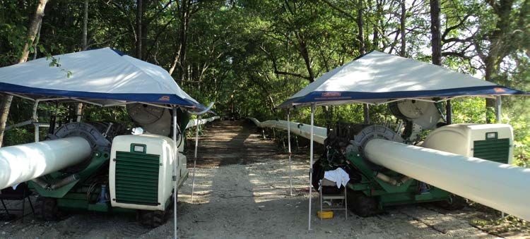
N                                       Charleston

                                                                        James Island
                                                   Johns Island
                                                                             Stono River

                                     Wadmalaw
                                      Island            Project Site

                                      Kiawah River

                                     Seabrook                    Kiawah Island
                                                                                       Atlantic
                                      Island
                                                                                       Ocean
                                              Figure 1. Location map.

Development and advances on the island are the responsibility of the Kiawah Partners (KP) comprised of the
Kiawah Island Club, Kiawah Island Real Estate, Freshfields Village, and Kiawah Island Utilities. The partners also
own unsold lands, provide recreational facilities, insure KP properties, approve home modifications and design of
new homes, and provide planning services to the community. In 1975, Kiawah Island Utility (KIU) was
incorporated and, soon after, a transmission main was installed from water lines supplied by St. Johns Water
Company (SJWC) on Johns Island to Kiawah Island, providing water to the residents on the island. KIU’s potable
water usage increased rapidly with development on the island, rising from 800,000 gallons per day in 1978 to the
current 3,600,000 gallons per day.

Kiawah Island’s geography of beaches on the Atlantic, shores along the Kiawah and Stono Rivers, various lagoons,
and wetlands make it an ideal retreat and habitat to diverse species of flora and fauna. To protect its natural
landscape, the Kiawah Island Conservancy (KIC) was established in 1997. The KIC controls the land and
conservation easements on the island, having conserved 324 acres of barrier island environment since its inception.
Johns Island, north of Kiawah Island and also bordered by the Stono and Kiawah Rivers, contains a similar nature to
that of Kiawah Island. It was previously filled with large plantations, many of which produced the major cash crop,
indigo. Currently, Johns Island contains large private properties with some upscale homes between the creeks,
rivers, marshes, and live oak trees that have been present throughout its history (see Figure 2). One of these trees,
called the Angel Oak, is estimated to be between 700 to 1,400 years old. These geographical features called for a
conservancy on Johns Island as well, to protect the land from overdevelopment into these habitats.

                 Figure 2. Island environment [marsh land (left); live oaks on Johns Island (right)].

Population growth on both islands elicited the need for utility improvements to support its residents. Back in 2007,
SJWC reinforced their water supply from Charleston with a new 24-inch pipe, crossing the Stono River from James
Island in an over 4,000-foot horizontal directional drill (HDD) of fusible polyvinyl chloride pipe (FPVCP). Once
across the river, the new water line was installed by both open trench and HDD methods following River Road
through the southern half of Johns Island. HDD of FPVCP was again used to install the water line under live oaks in

                                                Paper TA-T2-01 - 2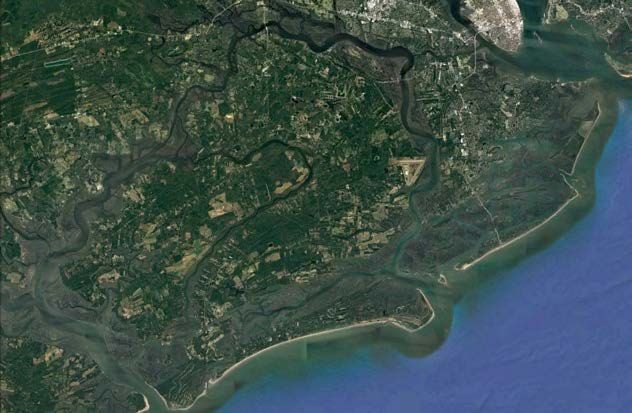
the area without disturbing the centuries old trees. In 2011, KIU also began to design a new water line. The original
transmission main installed around the time of KIU’s establishment was the sole potable water main supplying
Kiawah Island with water purchased from SJWC. The line consisted of a 16-inch ductile iron pipe that was laid at
the bottom of salt marshes and under Kiawah River (the shared border between Johns Island and Kiawah Island)
with shallow burial. With construction methods limited to cut and cover methods by the technology available at the
time of its installation, this metallic pipeline was exposed directly to the marsh environment. The exposure caused
corrosion in the line over its 30+ years of service which led to increasingly frequent leaks in the main, including four
leaks in the first six months of 2011. Kiawah Island development plans for further growth on the island demanded
that the water supply be secure. This new line would not replace the existing line, but serve as an alternate water
supply.

Kiawah Island was to host the 94th PGA Championship in August 2012. The idea to install a redundant line had been
a concept considered for at least a decade prior, but was now underway with intentions to provide an upgraded water
system during the tournament. Thus, KIU enlisted Thomas & Hutton Engineering Co. to tackle the challenge and
design the new water line. As expected, the project would require extensive permitting and easement procurement
for such an undertaking; this in addition to the daunting task of crossing the Kiawah River from Johns Island. The
task proved too complex to allow construction to be completed before the 2012 PGA Championship.

3.       PROJECT DESIGN

Thomas & Hutton completed multiple siting studies on both islands to evaluate the best method of crossing the
Kiawah River and the wetlands to either side. The initial alignments varied significantly in order to look at all
possible routes, at which point discussions began with affected property owners to determine what land KIU could
have permission to use. Generally, the proposed water main would require a significantly longer length of pipe on
Johns Island compared to that needed on Kiawah Island based on the connection point to the SJWC water main;
thus, the majority of property owners involved were Johns Island residents. Based on these discussions, the planned
water line alignments were revised to create additional alternate routes that better met the land owners’ needs. A
total of 14 alternate routes were considered to install the new water line from Johns Island to Kiawah Island. For
each route, the engineer evaluated the easements required and their associated costs, the estimated total cost for
construction, as well as the advantages and disadvantages of the alignment in regards to a number of factors
including the environmental impact and constructability. Of the 14, the alignment that was initially preferred
involved an approximately 5,000-foot HDD crossing of the Kiawah River. Thomas & Hutton started to develop
plans for this route and had completed geotechnical and survey work for the pipe alignment and layout when the
land owners changed their minds and chose to not allow the easement.

This change drastically impacted the timeline of the project. Not only did a new alignment need to be designed, but
new easements would need to be created and negotiated, a process that had already caused significant delays in the
design. Because the easement issue was on the Johns Island side of the Kiawah River crossing, the location of the
HDD entry point on the Kiawah Island side remained the same. The HDD exit point on Johns Island was shifted
west, essentially pivoting the initial 5,000-foot alignment from the entry point on Kiawah Island, such that the new
alignment was at more of an angle to the river instead of perpendicular to it. The initial location of the HDD exit
point was on higher ground and enabled a shorter distance across the river; this new HDD exit point was on lower
ground. That with the angled alignment increased the HDD crossing length to approximately 7,000 feet. The final
alignment of the proposed water main connected to the 24-inch SJWC water main north of Briar’s Creek, ran south
closely following an existing power line easement, crossed the river at an angle and then followed roads in a Kiawah
Island neighborhood to the Down Island Pump Station (DIPS). This alignment contained two short bores in addition
to the 7,000-foot bore under the river, an 840-foot bore under Chaplin Creek and the surrounding wetlands on Johns
Island and a 550-foot bore under a lagoon near homes in Kiawah Island (see Figure 3).

                                                Paper TA-T2-01 - 3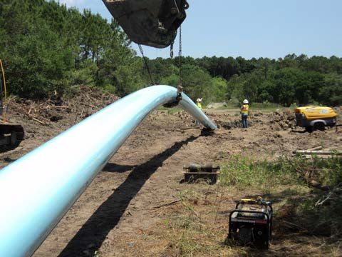
River Road
                                                                                                               N

       Connect to Ex. 24-
      inch St. Johns Water
     Company Water Main

                                                           840-foot HDD
                                     Briar’s
                                     Creek

                                                   Chaplin Creek

                                               Div 1

                                                                                      Kiawah River
                                                   Div 2

                                                                                              550-foot HDD
                                    7,000-foot HDD                                            under lagoon
                                                                           Div 2
           HDD                                                                               Connect to Ex. Down
                                                                                   Div 3
           Open Cut                                                                          Island Pump Station
                                                                   Governors Drive
                                     Figure 3. Redundant water line alignment.

Now that the route was revised to not cross the property of interest in the initial alignment, Thomas & Hutton had a
new set of easements to deal with, again on the Johns Island side of the project. The route was now within a
conservation easement for the river that required KIU and the engineer to minimize disturbance as much as possible.
Several of the properties along the new easements were owned by heirs to the previous owner and were, therefore,
not necessarily occupied. It became a challenge to get into contact with these heirs, requiring legal action to gain
access and obtain easements crossing those properties. Other land owners within the desired easement had their land
appraised for either permanent or temporary easements and were paid for use of their property.

The three segments noted in Figure 3 to be installed by HDD required the use of trenchless technologies to minimize
impact to the protected critical wetland regions and bodies of water they crossed. For the Kiawah River crossing,
HDD was the only installation method considered as it was the only method that would be approved from a
permitting stand point. For the two shorter bores, however, the designer also considered rerouting the water line to
avoid the critical areas and simply use open trench methods to install the pipe. This option would require additional
excavation, restoration and, in the case of the Kiawah Island side of the project, a very tight installation in a
congested work area near homes. Due to the additional costs and work area concerns of open trenching, HDD
methods would be less expensive and provide a much quicker installation, resulting in a lessened impact on the
residents. Open trench methods were employed outside of the HDD segments of the alignment in areas without
critical wetland concerns.

In general, 16-inch bell-and-spigot (B&S) PVC pipe was specified for the open trench segments in the alignment. In
the shorter drills, initial design considered high density polyethylene (HDPE) pipe and FPVCP. Ultimately HDPE
was eliminated as an option to avoid installing a mixture of pipe materials along the alignment. A uniform material
simplified any repairs or additions to the line in the future. For the long HDD across the river, the engineer
considered both steel and FPVCP for the water main material. This water main segment would be exposed to an
aggressive salt environment, requiring cathodic protection on any metal in the system. Steel was initially considered
due to concerns that FPVCP would not be able to withstand such a long bore, but the supplier recommended

                                                   Paper TA-T2-01 - 4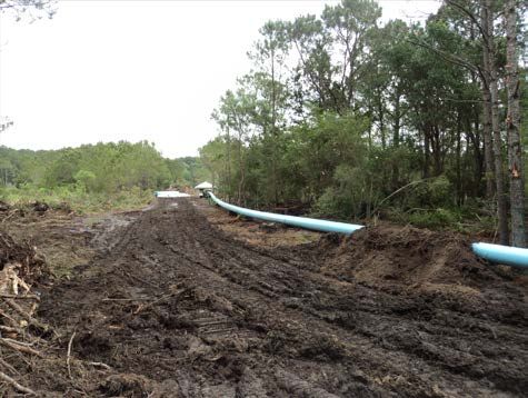
installing a thicker pipe, DR 14 instead of the DR 18 specified for the rest of the line, and assured the engineer that
this would provide the necessary pull force capacity to make the river crossing. The cost of cathodic protection
required on the steel line and the public’s negative perception of steel for a water main (steel was not a material
commonly used in the area) made steel a less desirable pipe material option. With these other material options
removed from consideration, the engineer specified only FPVCP for all bores on the project.

The location of the project presented a number of obstacles with one of the largest being its proximity to residents
on Kiawah Island and some facilities on Johns Island. There was a secluded golf course west of the project site on
Johns Island, Briar’s Creek Golf Club. The course was not directly adjacent to construction but, as a precaution, the
plans included requirements to create temporary sound barrier wall systems to block construction noise from the
club members. Such sound barriers were more significant for Kiawah Island construction. All high ground areas of
the island were occupied by houses or roads, leaving only the lower marsh areas for setup of the HDD entry pit and
staging. Sound barriers were required here to both muffle construction sounds and screen the visual impact of the
project site from home owners looking right onto the drill site.

The largest factor controlling the project timeline was the acquisition of permits and easements for the water line
route. A long list of permits was required prior to the start of construction. The permits necessary for construction on
Kiawah Island were obtained relatively quickly because Kiawah is its own town, facilitating the approval process.
Johns Island, however, is part of Charleston County which has a slower permit approval process. The main permit
from the county required several iterations due to concerns about the larger trees on the island. The greatest impact
to the schedule came from the land owner disallowing the use of their property for the initial design. The process of
halting design, scrapping the work completed, starting new, and acquiring new easements, set the project schedule
back by at least a year and a half. Thomas & Hutton had the FPVCP supplier and Mears Group, Inc. (Mears), the
HDD contractor that KIU was considering to complete the long river bore, walk the site ahead of time to help them
determine what easements would be necessary to layout the long string of pipe for the Kiawah River crossing.
Development of the new easements began in 2014 and were finally in hand by the end of May 2015. Applications
for permits started soon after, during the bidding process, and were approved by the end of 2015.

4.       PROJECT BIDDING

After numerous delays and revisions, the Kiawah Island Redundant Water Supply Main project advertised to bid on
May 29, 2015. The project was split into three divisions that could each be bid on and awarded to separate
contractors. The 7,000-foot drill across Kiawah River was considered a specialty project in itself and, thus, was
broken into its own division. That left the pipe to either side of the river crossing, both on Johns Island and Kiawah
Island. There is a 45 to 50-minute drive between the two islands, prohibiting a contractor from feasibly working on
both islands simultaneously, prompting the engineer to separate the work on Johns Island and the work on Kiawah
Island into separate divisions. Apart from the travel time, the work on the respective islands were essentially
different water line projects with their near opposite project sites. The water line installation on Johns Island was
located in heavily wooded, undeveloped lands versus the very congested, ornate, highly landscaped site on Kiawah
Island. The segment on Johns Island from the connection to the SJWC water main up to the HDD under Kiawah
River was designated as Division 1, the HDD under Kiawah River made up Division 2, and the water line on
Kiawah Island from the Kiawah River HDD connection to the DIPS was named Division 3 (see Figure 3).

Each division had its own set of plans and project specifications. The engineer had already pre-qualified Mears to
complete the river crossing in Division 2. They had initially assumed that Mears would not want to be involved in
the shorter bores in Divisions 1 and 3 but, after expressing interest, Mears was set to complete the shorter bores as
well. The HDD lengths through all three divisions were negotiated, not bid, with KIU. Mears, who would typically
bid as a HDD subcontractor, negotiated a contract with KIU to complete all three bores as the prime contractor,
purchasing pipe and fusion services directly from Underground Solutions, Inc., the FPVCP supplier and pipe fusion
subcontractor. Divisions 1 and 3 of the project (now without the HDD lengths) were bid using the typical award
process. The same set of contractors would likely bid on both divisions, consequently the engineer staggered the bid
dates to allow contractors time to prepare for and bid each division. Division 1 bid first since the plans were farther
along in design at the time, followed by the Division 3 bid a couple months later. The Division 2 contract was
negotiated with a lump sum price provided by Mears for all of the HDD. Divisions 1 and 3 were unit price contracts
that required the contractor to provide unit prices for all items according to the list of items and quantities provided
by Thomas & Hutton. Anson Construction Company, Inc. (Anson) was the lowest bidder for both Divisions 1 and 3.

                                                Paper TA-T2-01 - 5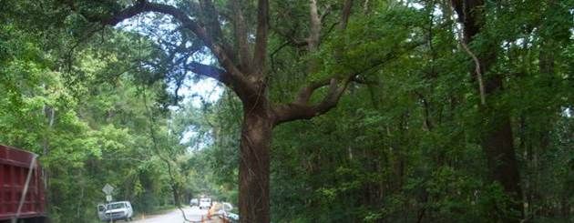
The contractor wanted to install these back to back, first Division 1, then Division 3, but this would add another five
to six months to the project duration. After discussions between Anson, the engineer, and KIU, Anson agreed to
only work on Division 1 and allowed the second lowest bidder, RH Moore Company, to be awarded Division 3.
KIU had to pay a bit more but ensured a shorter construction timeline.
5. CONSTRUCTION
At this point, Kiawah Island Utilities was sold to SouthWest Water Company of Birmingham, Alabama. SouthWest
Water provides a broad range of operations, maintenance, and management services for water and wastewater
systems in Alabama, California, Oklahoma and Texas, in addition to South Carolina. Construction began with a
project kickoff meeting on May 4, 2016. The 16-inch DR 18 FPVCP for the two short bores was delivered to the
project site only five days later. The approximately 550-foot bore on Kiawah Island (part of Division 3) was the first
to be installed. This bore, even though the smallest of the three, required the most extensive preparation in terms of
traffic control. The water main segment crossed under Blue Heron Pond Road, a lagoon, and environmentally
critical areas with an HDD exit and pipe insertion pit coming out on the shoulder of Governors Drive. The HDD
entry pit and staging area were located to the east, above the DIPS. The proximity to the residents along Governors
Drive required the construction and pipe layout to have the smallest footprint possible. Governors Drive is home to
several high valued houses, many of which are rented out as vacation homes. The two-lane road did not have a
sidewalk, requiring fusion of the FPVCP to take place in the lane closest to the bore and the pipe to be laid out on
the front edge of private properties. For this to be possible, the lane was closed from the pipe entry pit location back
to the fusion machine and flaggers were employed to pass oncoming traffic through the remaining lane (see Figure
4). The entire length could not be strung out without blocking driveways, necessitating multiple pipe strings, to
eventually be joined by intermediate fusion prior to pullback. The length was broken into two 180-foot pipe strings
and one 225-foot string that spanned the distance between two properties without blocking their driveways (see
Figure 4). The pipe strings were fused in two days in the second week of May and the intermediate joints were fused
a few days later once the borehole was ready for pipe pullback.
Figure 4. Traffic control for lane closure to fuse FPVCP strings.
The fact that the area consisted largely of vacation homes worked to the contractor’s advantage as, not yet being
summer, the homes in the immediate vicinity of the drill and pipe layout area were vacant, lessening concerns of
noise disturbance. After completion of the two intermediate fusion joints and a low pressure air test, the 16-inch pipe
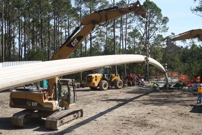
string was pulled back through the borehole in the same day, on May 14, 2016 (see Figure 5). The line was
successfully hydrostatically pressure tested the following week at 150 psi for a duration of two hours.
Figure 5. Pullback under lagoon on Kiawah Island [aerial insertion into HDD exit (left); pull into borehole (right)].
Paper TA-T2-01 - 6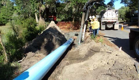
Fusion for the approximately 840-foot bore on Johns Island (part of Division 1) was completed in the week after the
Kiawah Island bore. Johns Island presented a different set of conflicts, less to do with confined work space and more
to do with installing a pipe system through a predetermined corridor of easements. The HDD segment crossed under
freshwater wetlands, environmentally critical areas, and Chaplin Creek, running parallel to and east of the timber
footbridge over Chaplin Creek (see Figure 6).

                                   Figure 6. Timber footbridge over Chaplin Creek

The drill rig and HDD entry point were set up on the northern end of the bore with pipe fusion and insertion pits set
up on the southern end. Fusion of the FPVCP was completed in three days in the third week of May. The full length
of pipe was laid out following the easements acquired for the open trenched water line alignment in the area and the
pipe string layout for the Kiawah River carrier pipe. These easements contained curves that the pipe string had to
negotiate to reach the pipe insertion pit. The layout for this bore required curving through an approximately 500-foot
radius (see Figure 7). After a preliminary low pressure air test to ensure no leaks were present, the pipe string was
pulled back through the borehole on May 24, 2016 (see Figure 7). The pipe segment was successfully pressure
tested soon after at 150 psi for a duration of two hours.

Figure 7. Layout and installation under Chaplin Creek on Johns Island [curved layout (left); aerial insertion (right)].

The 7,000-foot Kiawah River crossing was the final bore to be completed in this project. The length and depth,
designed to reach a maximum depth of 85 feet giving 50 feet of cover under the deepest point of the river, stretched
the capabilities of the HDD technology as well as the experience of all involved. The crossing was bored from
Kiawah Island to Johns Island making Kiawah Island the site of the drill rig and HDD entry staging area. The pipe
was staged, as designed, through the countless easements secured on Johns Island.

Regulations on Kiawah Island only allowed the contractor access between 7 A.M. and 7 P.M. each day, preventing
work from starting until as late as 8 A.M. due to the time it took to set up and requiring break down of construction
prior to the mandated departure time. This was not an issue for the previously installed shorter drill on the island but
proved trying while Mears drilled the 7,000-foot borehole under Kiawah River. The HDD entry was located in
marsh area below many residents within earshot and eyeshot of the staging area. One home was located such that the
kitchen and living room looked directly onto the drill site. Sound barrier structures were built on the sides of the
staging area to cut off the direct path of sound to the occupants in the nearby homes.

                                                Paper TA-T2-01 - 7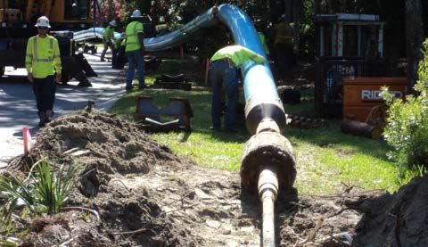
Outside of concerns in successfully creating and maintaining the required borehole, the design focused heavily on
creating an appropriate layout area for the lengthy pipe string prior to pullback. Both Mears and Underground
Solutions provided feedback to the designer to help them secure the correct easements. Ideally, the easement
necessary for the pipe string layout would overlap with easements needed to install 16-inch PVC by open trenching
to allow one easement to work for both systems. The proposed water main alignment also intentionally followed an
existing power line easement that runs from the Berkeley Electric Cooperative substation on Johns Island to Kiawah
Island. The power company had completed a drill under the river previously that was located near the proposed
water line crossing. The contractor was able to use their easement and the associated clearing as a temporary
construction easement for access. The water line easement ran adjacent to the power easement for a section of it.
Generally, a 30-foot wide temporary construction easement was established to string the FPVCP back from the
HDD exit through the allowed Johns Island properties. The overall pipe string alignment contained three significant
horizontal curves to fit within the angles of the easement. In such a long pipe string, a curve this tight can easily be
pulled past the minimum radius during pullback. Extreme care was required to ensure that localized over bending
did not occur.

Two fusion machines were set up to fuse two pipe strings simultaneously and thus increase production rate (see
Figure 8). The carrier pipe was fused into a 4,600-foot length and a 2,400-foot length that would be fused together
during pullback.

               Figure 8. Fusion of 16-inch DR 14 FPVCP using two T-900 machines simultaneously.

The Kiawah River crossing, a record length for the diameter and pipe material, used conventional design geometry
to avoid any unnecessary risks. The alignment had one horizontal curve with a 2,000-foot radius. The soil conditions
consisted of variable layers of generally loose sand with silt and clay to a depth of 55 feet below ground surface.
Below these layers is a formation known as the Cooper Marl, classified as MH (inorganic silts of high plasticity),
CH (inorganic clays of high plasticity) or SM (silty sands) with a primary constituent of calcium carbonate. The
material encountered consisted of firm to stiff clay or silt. This formation is considered very good for horizontal
directional drilling.

Pull load and pipe stress calculations were completed that considered the HDD loads as well as the friction due to
the pipe on rollers above ground. An important consideration was the total tensile stress as the pipe was pulled
around the horizontal bends in the layout. The calculations indicated a reasonable level of stress through the curves
as long as the planned radii were maintained.

Pullback began in the morning on October 28, 2016 (see Figure 9). Once the first 4,000 feet of the 4,600-foot pipe
string was installed, the 2,400-foot pipe string was joined with an intermediate fusion. The pipe was successfully
pulled through the borehole under Kiawah River by the early morning on October 29, 2016.

                                                Paper TA-T2-01 - 8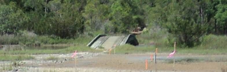
Figure 9. Aerial insertion into the bore under Kiawah River.

The pull-in duration was approximately 17 ½ hours; pull loads were consistent with the estimated values and had a
maximum value of 88,000 pounds, 50% of the pipe’s recommended value (see Figure 10). The water line crossing
was successfully pressure tested a week later at a pressure of 150 psi for two hours. Final connections to the pipe
installed in open trench were made in early December 2016.

                        Figure 10. Recorded pull load during 7,000-foot HDD installation.

                                              Paper TA-T2-01 - 9
6.       CONCLUSION

Overall, this project was considered a huge success, especially considering the difficulty level of the largest feature
in the alignment. KIU had been trying to get this new water line installed for over a decade. Even once in the design
phase, the nature of the project area impinged on the project schedule, delaying construction to 2016 for a design
that was initiated in 2011. Its completion was a relief to KIU.

Aside from the residents of Johns Island whose land was purchased for the duration of the project and perhaps those
living adjacent to the drill rig for a few months, there was minimal disruption to the residents of both islands. There
were some that didn’t appreciate the noise but, generally, residents were very patient considering the increased
project duration due to unforeseen issues and challenges.

Cooperation and collaboration between KIU, Thomas & Hutton, and Mears ensured a thorough, well-designed water
line that stretched the limits of horizontal directional drilling technology. Now Kiawah Island will be prepared to
host the 2021 PGA Championship with an updated and dependable water supply system.

7.       REFERENCES

Kiawah Island Utility Official Website. Retrieved from http://www.kiawahislandutility.com/

Preservation Consultants Inc. (1989). James Island and Johns Island Historical and Architectural Inventory.

Thomas & Hutton Engineering Co. (2015) – Contract Documents and Specifications for the Kiawah Island
Redundant Water Supply Main Project, Kiawah Island, SC.

Town of Kiawah Island Official Website. Retrieved from http://kiawahisland.org/

                                               Paper TA-T2-01 - 10
You can also read