Papamoa East - Te Tumu - Deloitte
←
→
Page content transcription
If your browser does not render page correctly, please read the page content below
Papamoa East - Te Tumu
TE TUMU LANDOWNERS GROUP
(TTLG)
Comprises of the Main Landowners in the Papamoa East – Te
Tumu Area
Formed in December 2004
To Respond to the SmartGrowth Strategy and Address
Infrastructure, Land Use Planning & Integration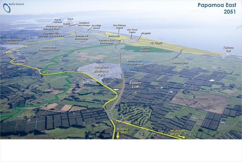
TE TUMU - LAND HOLDINGS
                                                                  6 ha

                                                         243 ha
             241 ha
                            171 ha

LEGEND                                      TE TUMU LANDOWNERS GROUP
A: Te Tumu Kaituna 14 Trust                 A: Te Tumu Kaituna 14 Trust
B: TCC / WBoPDC                             B: Carrus-Hickson Development Interests
    (Carrus-Hickson Development Interests   F: Ford Land Holdings Pty Ltd
C: Te Tumu Kaituna 7B1 & 7B2 Trusts         G: Te Tumu Kaituna11B2 Trust
D: Te Tumu Kaituna 8B1 Trust
E: Catalyst (Highrise) Ltd                  The Te Tumu Landowners Group
F: Ford Land Holdings Pty Ltd               Interests Make Up 87% of the 760ha Te
G: Te Tumu Kaituna 11B2 Trust               Tumu Urban Growth Area (UGA).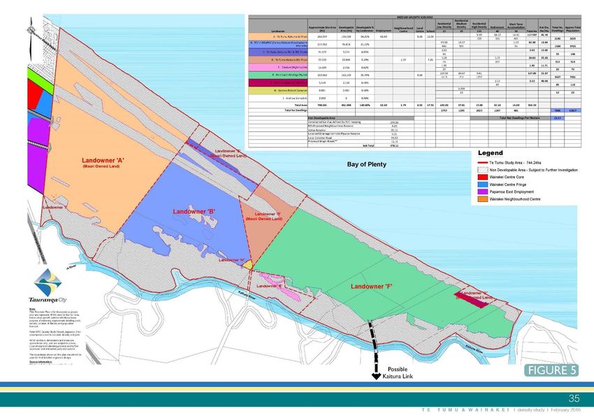
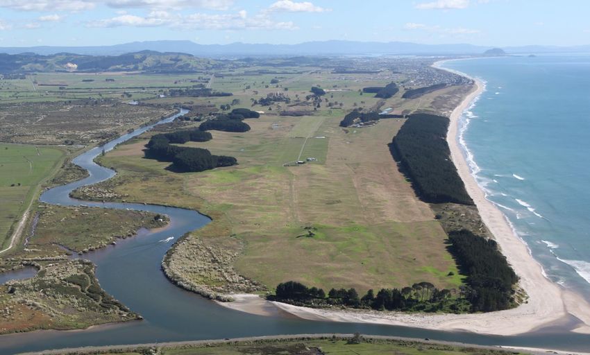
THE SITE & SCALE

760 hectares / 1878 acres

                   2km

        6km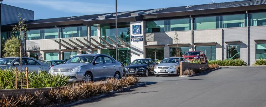
THE PLANNING CONTEXT
THE TE TUMU PLANNING CONTEXT Identified in the SmartGrowth Strategy as a Future Urban Growth Area Identified in the Regional Policy Statement as a Future Urban Growth Area Identified in the Tauranga City Plan as a Future Urban Zone Approved to proceed to Structure Planning and Re-Zoning in 2017-18 by SmartGrowth and Tauranga City Council in August 2016.
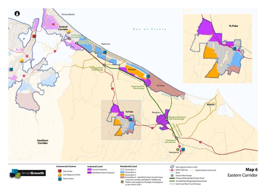
THE ‘SmartGrowth’
EASTERN CORRIDOR VISION
TE TUMU LANDOWNERS
 History
Te Tumu Kaituna 14 & 11B2 Trusts   Carrus Hickson Interests
• Ngati Whakaue Iwi Land Trusts    • The Hickson Family connection and
• A Te Arawa Iwi                     ownership of the property extends
• Connection with the land goes      back to 1960.
  back to the landing of the       • Carrus Corporation entered into a
  Te Arawa Waka at Maketu            Joint Venture with the Hickson
                                     Family in 2004.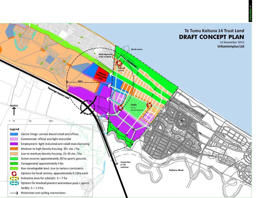
TE TUMU LANDOWNERS
History
Ford Land Holdings Pty Ltd
• The Ford Family have been in the Te Tumu area since 1907 as farmers and
  landowners.
• The Ford Family connection to their current Te Tumu landholdings extends back
  to 1911.
TE TUMU LANDOWNERS Experience Te Tumu Kaituna 14 & 11B2 Trusts Extensive Property Development experience through the Pukeroa Oruawhata Trust and Ngati Whakaue Tribal Land Inc including: Rotorua Central Mall. Trade Central Retail Centre Rotorua. Rotorua Lakefront (in planning phase).
TE TUMU LANDOWNERS Experience Carrus Corporation Formed by Paul Adams in 1990 Residential developments is its major focus, but Carrus has also done retirement villages, rural residential, industrial and commercial developments Carrus has done developments , besides Tauranga but also in Auckland, Rotorua, Taupo, Palmerston North, Hamilton and Wellington Carrus has developed and sold over 4600 sections Carrus purchased The Lakes in 2012 and to date has sold 455 sections. There is currently 147 sections under construction and a further 739 sections to develop
TE TUMU LANDOWNERS Experience Ford Land Formed by Geoff and Dianne Ford in 1981. Developed in excess of 300,000m2 of Commercial & Industrial Property in Sydney. Currently Master Planning a 2,000 dwelling mixed use development in western Sydney
LAND USES – VISION & OPPORTUNITIES Commercial Centre - Incorporating Commercial Area & Education and Health Precincts Education Precinct – University, Polytechnic, High School, Primary School Health Precinct – Hospital, Specialist Health Facilities, Teaching Hospital Affordable Housing – On Leasehold Land Community Facilities – Holiday Park, Sports Facilities, Network of Parks, Reserves, Walking Trails & Cycling Trails
Te Tumu – Planning Initiated by TCC in 2015 as a ‘fatal flaws’ assessment to test the viability of the Te Tumu Future Urban Growth Area. Considered planning constraints, infrastructure requirements, financial viability and Tangata Whenua considerations. Assessed potential population and employment scenarios together with the requirements for future reserves and community facilities. Completed in July / August 2016 with the outcome: “On this basis, the planning study’s conclusions and consultation with stakeholders, SmartGrowth and Council have decided to proceed with the future planning for Te Tumu with a view to opening the growth area in 2021. This decision was part of a wider integrated package of projects including delivery of future growth in Tauriko West and a Compact City.”
Te Tumu – Drivers & Demand Pent-up housing demand combined with low interest rates and high migration resulting in high growth and upcoming shortage of land supply. Proposed National Policy Statement (NPS) on Urban Development Capacity will require High Growth Council’s to maintain a 10 year supply of zoned residential land.
Te Tumu – Drivers & Demand NPS Growth Prediction for Tauranga is 15.1% for 2013-23, second only to Auckland at 18.1%. Current Land Supply in Tauranga estimated at 9.5 years, based on current growth. By 2019 it is estimated that the Land Supply in Tauranga will be 4.5 years.
Te Tumu – Planning
Te Tumu – Planning
Te Tumu – Planning
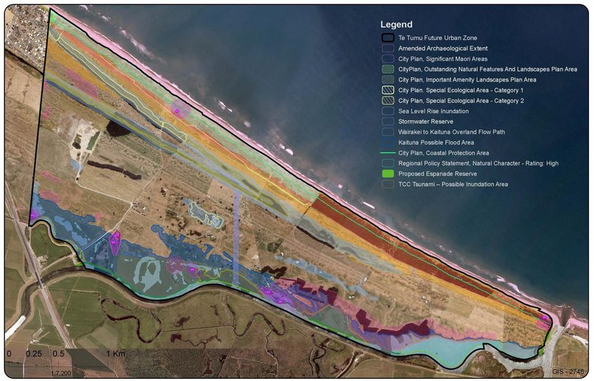
Constraints Mapping
Density & Developable Areas
Te Tumu Density & Developable Areas RPS 2016 Report Net Developable Land: 366 ha Median Growth Scenario: 7846 dwellings, 15817 population Net Dwellings / Hectare: 23.97. High Growth Scenario: 8923 dwellings, 17599 population Net Dwellings / Hectare: 29.03.
Te Tumu Kaituna 14 Density & Developable Areas RPS 2016 Report Developable Land: 151.00ha (incl roading) Employment Land: 62.60ha School(s): 10.36ha Median Growth Scenario: 2140 dwellings, 3235 population High Growth Scenario: 2230 dwellings, 3355 population
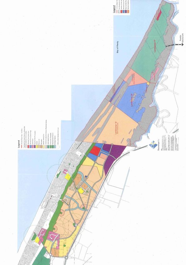
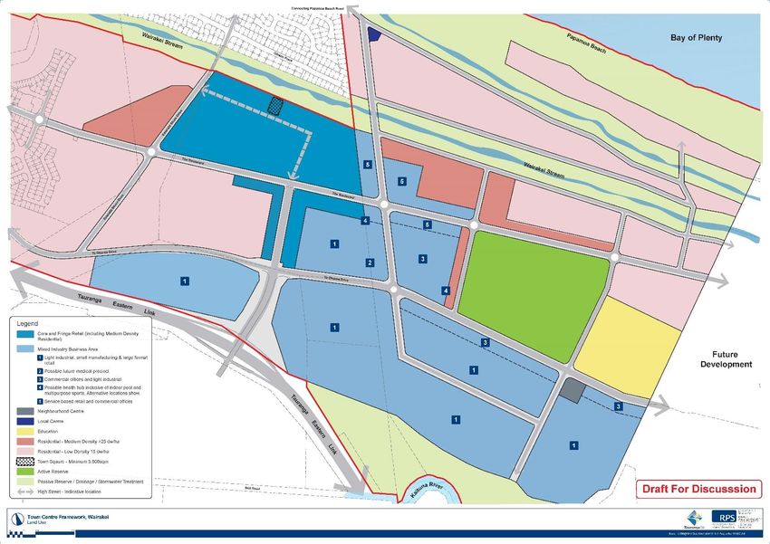
Cross Boundary Integration

                   Cross Boundary Framework Area
Draft Concept Plan
Cross Boundary Framework Plan
TTK14 Opportunities - Education
Schools – 10+ hectares
TTK14 Opportunities - Health Precinct
Medical Facilities – 5+ hectares
Te Tumu Planning Timeline 2016: Cross Boundary Framework Plan 2017 – 2018: Structure Planning & Plan Change Preparation 2018: Council Hearings & Decisions 2019 – 2020: Commence Development
THE TE TUMU
VISION
You can also read