PERFORMANCE ASSESSMENT OF PPP-AR POSITIONING AND ZENITH TOTAL DELAY ESTIMATION WITH MODERNIZED CSRS-PPP
←
→
Page content transcription
If your browser does not render page correctly, please read the page content below
ARTIFICIAL SATELLITES, Vol. 56, No. 2 – 2021
 DOI: 10.2478/arsa-2021-0003

 PERFORMANCE ASSESSMENT OF PPP-AR POSITIONING
 AND ZENITH TOTAL DELAY ESTIMATION
 WITH MODERNIZED CSRS-PPP

 Omer Faruk ATIZ, Ibrahim KALAYCI
 Department of Geomatics Engineering, Necmettin Erbakan University,
 Konya, Turkey
 e-mails: oatiz@erbakan.edu.tr, ikalayci@erbakan.edu.tr

ABSTRACT. The precise point positioning (PPP) method has become more popular due to
powerful online global navigation satellite system (GNSS) data processing services, such as
the Canadian Spatial Reference System-PPP (CSRS-PPP). At the end of 2020, the CSRS-PPP
service launched the ambiguity resolution (AR) feature for global positioning system (GPS)
satellites. More reliable results are obtained with AR compared to the results with traditional
ambiguity-float PPP. In this study, the performance of the modernized CSRS-PPP was
comparatively assessed in terms of static positioning and zenith total delay (ZTD) estimation.
Data for 1 month in the year 2019 obtained from 47 international GNSS service (IGS) stations
were processed before and after modernization of the CSRS-PPP. The processes were
conducted for GPS and GPS + GLONASS (GLObalnaya NAvigatsionnaya Sputnikovaya
Sistema) satellite combinations. Besides, the results were analyzed in terms of accuracy and
convergence time. According to the solutions, the AR feature of the CSRS-PPP improved the
accuracy by about 50% in the east component for GPS + GLONASS configuration. The root-
mean-square error (RMSE) of the ZTD difference between modernized CSRS-PPP service
and IGS final troposphere product is 5.8 mm for the GPS-only case.
Keywords: ambiguity resolution, CSRS-PPP, precise point positioning, zenith total delay

1. INTRODUCTION
Precise point positioning (PPP) is a powerful positioning technique that can provide
millimeter-to-centimeter level of accuracy after a convergence time using precise satellite
orbit, clock, and other related products (Earth rotation parameter, differential code bias, and
so on) (Kouba and Héroux 2001; Zumberge et al., 1997). In the past years, the PPP method
has been extensively used in different studies for applications, such as determining
displacements, surface deformation, landslide monitoring, aircraft positioning, or even in
smartphones (Alcay et al., 2019; Atiz et al., 2020; Goudarzi and Banville, 2018; Krasuski et
al., 2018; Wang et al., 2015; Wu et al., 2019; Yigit et al., 2014). The global navigation
satellite system (GNSS) is used to determine the position, time, and navigation, as well as
estimate the total electron content (TEC) in the ionosphere layer (Otsuka et al., 2002) and
zenith total delay (ZTD) in the troposphere (Pikridas et al., 2014). However, for PPP
postprocessing, many software packages have been developed, e.g., RTKLIB (Real-Time
Kinematic Library) (Takasu and Yasuda, 2009), GipsyX (Bertiger et al., 2020), and PRIDE

 ©The Author(s). This is an open-access article distributed under the terms of the Creative Commons Attribution License (CC BY 4.0,
 https://creativecommons.org/licenses/by/4.0/), which permits use, distribution, and reproduction in any medium, provided that the
 Article is properly cited.
PPP-ambiguity resolution (AR) (Geng et al., 2019). In addition, some online software [e.g.,
Canadian Spatial Reference System-PPP (CSRS-PPP)] provide free PPP processing service
for only users registering with a valid mail address. The PPP method has become more
popular with free and user-friendly software, such as MG-APP (multi-GNSS automatic
precise positioning software) (Xiao et al., 2020), and online services that do not require any
expertise in the GNSS data-processing field, with the advantage of reduced field cost.
The CSRS-PPP service is an online PPP postprocessing service developed in 2003 and
operated by Natural Resources Canada (NRCan) to date (Tétreault et al., 2005). There are
many studies on the performance of CSRS-PPP and other online GNSS data-processing
services. Guo (2015) compared the precisions of the automatic precise positioning service
(APPS), GPS analysis and positioning software (GAPS), CSRS-PPP, and Magic-PPP
software in terms of static positioning and ZTD estimation. The results indicated that all four
software can give millimeter-to-centimeter level positioning accuracy. The results also
indicated that the accuracy of ZTD estimation derived from these online GNSS data-
processing services is on the scale of a few centimeters. Mendez Astudillo et al. (2018)
compared three online (CSRS-PPP, APPS, and Magic-PPP) and three offline (POINT,
RTKLIB, and GNSS Lab Tool suite-GLAB) PPP software in terms of ZTD estimation. It was
demonstrated that ZTD estimation of CSRS-PPP is very accurate. The root-mean-square
errors (RMSEs) of the difference from international GNSS service (IGS) final troposphere
products are mostly 70%. In Katsigianni et al. (2019), the
performances of the kinematic postprocessed PPP and the PPP-AR methods were analyzed.
For GPS-only kinematic PPP-AR, accuracy levels of 9.3/8.3 mm and 24.0 mm were obtained
for the horizontal components and the vertical component, respectively. AR improved the
PPP solutions by 1–3 mm for the east and north components. Tegedor et al. (2015) compared
the Real Time Kinematic (RTK), PPP, and PPP-AR methods in a vessel moving through
Oslo, Norway. The phase bias information for PPP-AR was generated from two different
nearby stations. The results showed that the AR approach on PPP improved the positioning

 19
accuracy. Goudarzi and Banville (2018) evaluated the performance of the static relative and
static PPP-AR approaches for determining land surface deformations. It was concluded that
the PPP-AR method showed better accuracy in terms of positioning and velocity. The results
also indicated that the PPP-AR processing time is significantly lower than that for the relative
method. Li et al. (2018) developed a multi-GNSS phase bias estimation model and multi-
GNSS PPP-AR positioning model. According to their results, for 2-hour sessions, the GPS-
only PPP-AR provided an accuracy level of 0.6/0.5/1.9 cm for the north, east, and up
components, respectively.
Moreover, the CSRS-PPP announced a modernization related to the software engine in 2018.
This modernization, which includes GPS AR, has become publicly available at the end of
2020. For more detailed information about the changes in the software, the reader is referred
to Banville (2020).
This study aims to investigate the performance of the modernized CSRS-PPP service in terms
of static positioning and ZTD estimation. For this purpose, 31 consecutive daily data of 47
IGS stations in 2019 were processed before and after the modernization of the software. The
processes were performed not only using GPS satellites but also combined with GLONASS
because the benefits of the combined use of different GNSSs are explicit, particularly under
limited sky view conditions (Alcay and Yigit, 2017; Alcay et al., 2012; Cai et al., 2013;
Jokinen et al., 2013; Ogutcu, 2020b; Ogutcu and Kalayci, 2016). Consequently, four different
solutions for each observation were obtained with GPS and GPS + GLO combinations, in two
steps, namely, PPP and PPP-AR. The position and ZTD results were evaluated in comparison
to IGS weekly solutions and IGS final troposphere product, respectively.

2. PPP WITH AR
In GNSS data processing, linear combinations of observations are used in many cases instead
of raw observations, e.g., the first-order effect of the ionosphere can be removed using the
iono-free (IF) combination (Subirana et al., 2013). In the traditional PPP model, AR is not
implemented due to the biases originating from GNSS hardware. In addition to precise
satellite orbit and clock correction, IGS analysis centers also calculate the satellite phase bias
information, which is necessary to acquire an ambiguity-fixed PPP solution (Håkansson et al.,
2017). For ambiguity-fixed PPP with IF combination, several approaches have been
developed, such as the integer recovery clock (IRC) model (Laurichesse et al., 2009), the
decoupled satellite clock (DSC) model (Collins et al., 2010), and the uncalibrated phase delay
(UPD) model (Ge et al., 2008). The same approach used by the analysis center for producing
phase/clock bias information should be applied to user solutions. Here, the utilization of
phase/clock bias products is software dependent. The CSRS-PPP with AR is based on the
DSC model. Therefore, the functional model of the DSC model is briefly introduced below.
The IF code and phase observables between a receiver–satellite pair can be written as follows
(Leick et al., 2015):

 = + ∙ ( − ) + + , − , + , , (1)

 Ø = + ∙ ( − ) + − ∙ + Ø, − Ø, + Ø, , (2)
where and Ø represent the IF code and phase observables, respectively; superscript
and indicate the receiver and the satellite, respectively; is the geometric distance between
the receiver and the satellite; is the speed of light; is the receiver clock error; is the

satellite clock error; , and , are the IF code biases for the receiver and the satellite,

respectively; Ø, and Ø, are the IF phase biases for the receiver and the satellite,

 20
respectively; is the IF wavelength; is the real-valued IF ambiguity term; and , and
 Ø, are the code and phase measurement noises, respectively.
For the sake of simplicity, the common errors that are appropriately modeled or eliminated,
such as satellite orbit error, phase wind-up, receiver/satellite antenna phase center variations,
and relativistic effects, are not given in Eqs. (1) and (2). The ambiguity term in traditional
PPP is real-valued as it absorbs the receiver and satellite code/phase biases. Therefore,
additional phase/clock biases are necessary for integer ambiguity-resolved PPP. However, the
ambiguity-fixed solution is only attainable when the receiver and the satellite code/phase
biases are calibrated.
The DSC model introduced by Collins et al. (2010) includes another linear combination
named Melbourne–Wübbena (MW) besides the IF combinations (Melbourne, 1985;
Wübbena, 1985). The MW combination is the difference between wide-lane (WL) phase and
narrow-lane (NL) code observations. The wavelengths of WL and NL combinations can be
written as follows:

 = − ; = + , (3)
 1 2 1 2

where represents the WL wavelength, is the NL wavelength, 1 and 2 are the dual
frequencies (e.g., GPS L1: 1575.42 MHz and L2: 1227.60 MHz). Accordingly, the MW
observable is expressed as follows:

 = − ∙ + − + , (4)

where represents the WL ambiguity, and are the MW receiver and satellite
biases, and is the unmodeled error of MW combination. The PPP DSC model consists of
three observables, as shown in Eqs. (1), (2), and (4). The unknown parameters of the DSC
model are as follows:
 = � ̅ , , , , ∗ , ∗ , � �
 , �, (5)
where ̅ is the receiver position update vector; ∗ and ∗ are the observation-specific receiver
and satellite phase/code biases; and � �
 and are the WL and IF ambiguities for each
satellite. Because the number of unknown parameters is more than the number of
observations, a datum deficiency problem occurs. To resolve this issue, a two-step approach is
used, namely, parameter reconstruction and introducing two new datums. First, the IF
ambiguity in Eq. (2) is decomposed as follows:
 ∙ = ∙ (17 1 + 60 ), (6)
where 1 is the carrier phase ambiguity on 1 frequency. Moreover, the decoupled clocks are
obtained with the combination of the clock parameters and their code/phase bias counterparts.

For instance, the decoupled code clock for a receiver is equal to + , . Consequently,
the observation equations for the reconstructed DSC model is formed as follows:

 = + ∙ � , − , � + + ,

 Ø = + ∙ � Ø, − Ø, � + − ∙ (17 1 + 60 ) + Ø, , (7)

 ( )
 = − − ∙ +

where , and , indicate the code-decoupled receiver and satellite clocks, and Ø,

and Ø, indicate the phase counterparts. The second step includes the definition of two new
datums, namely, clock datum and ambiguity datum (Shi and Gao, 2014). The clock datum is
determined as follows: first, a reference receiver is selected, and then its code/phase biases are

 21
nullified. The ambiguity datum is constructed as determining a reference satellite and
appointing its 1 and ambiguities to random integer numbers. Thus, the datum
deficiency problem is clarified. For more information about solving the datum deficiency
problem, the reader is referred to Shi (2012). The integer value of the ambiguity term is
calculated using these three DSCs.
The above-mentioned functional model can be applied for a single system PPP-AR. However,
GPS (AR) + GLONASS (float) solutions were derived in addition to GPS (AR). The
combined GPS + GLONASS PPP model is not given considering the scope of this study. The
reader is referred to Cai and Gao (2013) for information about the GPS + GLONASS PPP
model.

3. DATA AND PROCESSING STRATEGY
A set of 31-day data from geographically well-distributed 47 IGS stations in 2019 was
processed to test the performance of the modernized CSRS-PPP with AR. The data
availability was checked on the epoch basis using in-house software. Then, only the
observation files that have >90% available data were used in the processes. The processes
were performed for both GPS-only and GPS + GLO satellite configurations. Therefore, the
IGS stations were selected considering GLONASS availability. To validate the positioning
accuracy, IGS weekly combined solutions were taken as the reference coordinates. The
locations of the selected IGS stations are depicted in Figure 1.

 Figure 1. The location of selected IGS stations

The static PPP solutions were computed in two steps: before the software transition to AR,
and, after the modernization. Thus, PPP and PPP-AR solutions were obtained for GPS and
GPS + GLO satellite configurations. The data-processing strategy for both solutions is
provided in Table 1.

 22
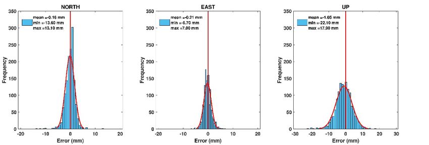
Table 1. Data processing strategy
 Parameter PPP PPP-AR
 GNSS GPS/GPS+GLO GPS/GPS+GLO
CSRS-PPP version 2.31.0 3.45.0
 Processing mode Static Static
 Filtering Forward Forward
 Epoch interval 30 s 30 s
 Cut-off angle 7.5° 7.5°
 Observations Phase and code Phase and code
 Frequencies GPS: C1W, C2W, L1W, L2W GPS: C1W, C2W, L1W, L2W
 GLO: C1P, C2P, L1P, L2P GLO: C1P, C2P, L1P, L2P
 Satellite orbit IGS Final NRCan Final
 and clock
 Satellite phase N/A NRCan
 ambiguity bias
 Ambiguities Float Fixed by using DSC model
 Ambiguity N/A Weighted Integer Decision
 validation (Banville et al., 2021)
 Estimated Coordinates, Total Zenith Coordinates, Total Zenith
 parameters Delay, Receiver Clock, Delay, Receiver Clock,
 Ambiguities, Slant Total Ambiguities, Slant Total
 Electron Content Electron Content
 Receiver clock Estimated as white noise Estimated as white noise
A priori troposphere Vienna Mapping Function 1 Vienna Mapping Function 1
 (VMF1) grid files (VMF1) grid files
Tropospheric zenith Random walk 5.0e-5 Random walk 5.0e-5
 delay m/sqrt(sec) m/sqrt(sec)
 Troposphere Random walk 1.667e-6 Random walk 1.667e-6
 gradients m/sqrt(sec) m/sqrt(sec)
 Slant ionosphere White noise 0.1 m/sqrt(sec) White noise 0.1 m/sqrt(sec)
 delay
 Reference Frame ITRF 2014 ITRF 2014
 Earth rotation IGS .erp file NRCan .erp file
 parameters
 Tidal effects Corrected (IERS Conventions, Corrected (IERS Conventions,
 2010) 2010)
 Antenna phase Corrected (Up-to-date NRCan Corrected (Up-to-date NRCan
 center offsets IGS14.atx file) IGS14.atx file)

 23
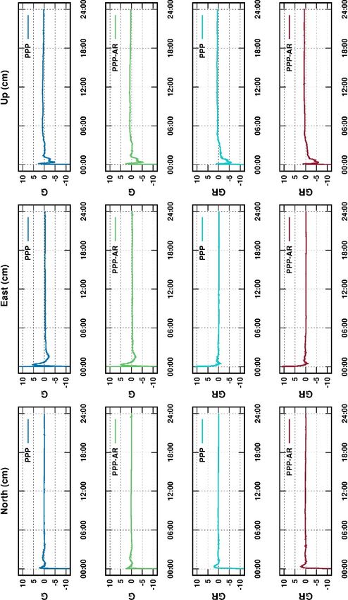
The cartesian coordinates (X, Y, Z) and ZTDs were obtained after utilizing the processes over
e-mail.
Before PPP performance analysis, changes in the ionosphere during the observations were
investigated since anomalies in the ionosphere layer can disturb the PPP results. Substantial
variations in the TEC value can indicate an ionospheric storm. Moreover, the space weather
condition indices provide information about ionospheric anomalies. There is an ionospheric
storm when any index value exceeds its expected threshold (Alcay and Gungor, 2020). The
geomagnetic storm (Kp), geomagnetic activity (Dst), and solar activity (F10.7) index values
(https://omniweb.gsfc.nasa.gov/form/dx1.html) were analyzed to check whether there was any
ionospheric storm during the observations (Figure 2).

 Figure 2. The Kp, Dst, and F10.7 index values

Figure 2 illustrates that there is no global ionosphere-induced storm that could affect the
GNSS observations during day of year (DOY) 305–336.

4. POSITIONING AND ZTD RESULTS
The ambiguity-fixing rates were computed as they are crucial for PPP-AR processing. Herein,
the fix rate is the percentage of resolved carrier phase ambiguities out of the total phase
measurements (Banville et al., 2021). It should also be noted that only GPS ambiguities are
fixed in the current PPP model of CSRS-PPP. Regarding the results, at least 84.40% and
79.75% of the ambiguities were fixed for GPS and GPS + GLO satellite combinations,
respectively. When the average ambiguity-fixing rates were examined, 97.62% and 97.68% of
ambiguities were resolved for GPS and GPS + GLO satellite combinations, respectively.
According to these results, the modernized CSRS-PPP software has successfully applied the
PPP-AR method.
The obtained Cartesian coordinates were converted to the topocentric system (north, east, up)
with respect to IGS weekly combined solutions. Then, the RMSE values for the results of
each station were calculated. Only the overall RMSEs are presented in this manuscript for the
sake of simplicity. Table 2 gives the overall RMSEs computed with GPS and GPS + GLO
satellite configurations for PPP and PPP-AR solutions.

 24
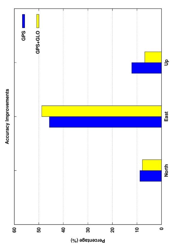
Table 2. RMS errors for GPS solutions
 GPS
 PPP PPP-AR
 North (mm) 1.84 1.68
 East (mm) 2.61 1.41
 Up (mm) 5.21 4.58
 GPS+GLO
 PPP PPP-AR
 North (mm) 1.81 1.67
 East (mm) 2.69 1.38
 Up (mm) 4.92 4.59

Table 2 displays that the GPS-only PPP offers accuracy of 1.84 mm, 2.61 mm, and 5.21 mm
for the north, east, and up components, respectively. When the PPP-AR counterparts are
considered, AR visibly improves the results, particularly in the east component. The
improvement percentages are illustrated in Figure 3 to visualize the accuracy improvement of
PPP-AR compared to PPP.

 Figure 3. The improvements in accuracy on using the AR approach

As shown in Figure 3, the AR approach improved solutions in the north and up components
by about 10%. AR significantly contributed to the east component with almost 50%.
However, Figure 3 implies that the difference between GPS and GPS + GLO satellite
combinations is not significant in terms of overall accuracy. Bertiger et al. (2020) investigate
the static PPP performance of Jet Propulsion Laboratory’s (JPL) GipsyX software, using 24-
hour data sets. They reported that GipsyX provides an accuracy of 1.90 mm, 1.98 mm, and
6.47 mm for the north, east, and up components, respectively. When compared to the
experimental results of this study, the modernized CSRS-PPP software offered slightly better
results than GipsyX for both horizontal and vertical components.

 25
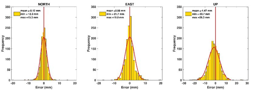
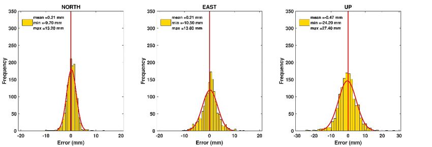
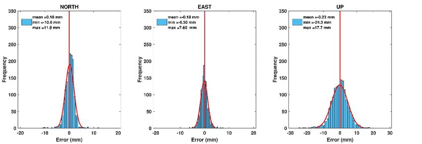
The repeatability of solutions should be analyzed in addition to accuracy analysis. To achieve
it, the standard deviation (STD) values were calculated using topocentric coordinates. The
overall STDs of PPP and PPP-AR solutions are given for both satellite configurations in
Table 3.

 Table 3. The overall STDs
 GPS
 PPP PPP-AR
 North (mm) 1.62 1.54
 East (mm) 2.12 1.21
 Up (mm) 4.30 3.89
 GPS+GLO
 PPP PPP-AR
 North (mm) 1.56 1.50
 East (mm) 2.02 1.20
 Up (mm) 4.23 3.99

According to Table 3, the STD values for the horizontal components vary between 1.21 mm
and 2.12 mm. Moreover, the STD values for the up component are between 3.89 mm and
4.30 mm. The error is defined as the difference of the PPP coordinates in relation to the
assumed real values, which herein are the IGS weekly solutions. The error distributions of
PPP and PPP-AR results are depicted in Figures 4–7.

 Figure 4. GPS PPP error distributions

 26
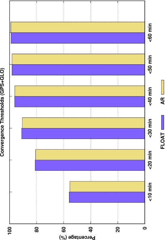
Figure 5. GPS PPP-AR error distributions

 Figure 6. GPS + GLO PPP error distributions

 Figure 7. GPS + GLO PPP-AR error distributions

When the results in Figures 4–7 are analyzed, both PPP and PPP-AR solutions show a similar
trend within the Gauss distribution. Thus, it is proved that there is no gross error in the
solutions. As seen from Figures 4–7, the horizontal components are in the range of
approximately −10.0/+10.0 mm, and the up component is in the range of approximately
−20.0/+20.0 mm. The mean values of the horizontal components of GPS and GPS + GLO
satellite configurations are better than 0.22 mm. However, the mean value of the up
components of GPS PPP is −1.47 mm. For GPS solutions, the AR approach improved the PPP
results by 0.42 mm to −1.05 mm in the up component. For the GPS + GLO satellite
combination, the PPP-AR method improved the mean values of the up component by

 27
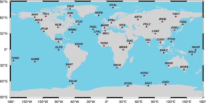
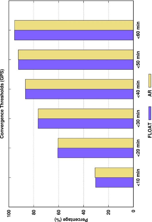
0.24 mm. It is also clearly seen that PPP-AR results significantly shrink the error distribution
range of the east component.
The convergence time is another topic related to positioning performance using the PPP
method. In this study, the static PPP convergence times were calculated as the processing is
based on forward filtering. For instance, the topocentric coordinate time series of PPP and
PPP-AR solutions for the ARTU station on DOY-305 is given in Figure 8.

 Figure 8. The coordinate time series of ARTU station on DOY-305

As illustrated in Figure 8, both GPS and GPS + GLO solutions were converged in a few
epochs. The convergence times were calculated using a 10-cm threshold value and validated
for 60 epochs (30 minutes). Thus, the mean convergence times were obtained for each station
and processing option. The overall mean convergence times are given in Table 4.

 Table 4. The overall mean convergence times
 GPS GPS+GLO
 PPP 21.4 min 13.1 min
 PPP-AR 21.4 min 13.2 min

As depicted in Table 4, GPS-only PPP solutions converged to 10 cm before 21.5 minutes.
However, the GLONASS satellites improved the convergence time by 8 minutes. Although
AR is expected to improve convergence time, herein, it did not show any significant
improvement on mean convergence times. For more in-depth analysis, the percentages of
converged solutions were assessed for different time intervals. The distributions of converged
ambiguity-float and ambiguity-fixed solutions considering different time intervals are shown
in Figures 9 and 10.

 28
Figure 9. The distribution of converged GPS-only solutions

 Figure 10. The distribution of converged GPS + GLO solutions

As seen in Figures 9 and 10, the number of converged solutions before 10 minutes is
approximately 30% for GPS, while it is approximately 55% for GPS + GLO. Similarly,
GPS + GLO gives better results for solutions in other time intervals. For PPP and PPP-AR
solutions, no significant difference was seen in both GPS and GPS + GLO satellite
configurations.
In addition to the positioning performance, the modernized CSRS-PPP was evaluated in terms
of troposphere estimation. To achieve that, the ZTD values of the PPP and PPP-AR solutions
were analyzed for both GPS and GPS + GLO satellite configurations. The ZTD values were
compared to the state-of-art IGS final troposphere product. Moreover, it should be noted that
the IGS final troposphere product comes in 5-minute time interval. Therefore, CSRS-PPP
solutions were decimated to 5-minute epoch interval for comparison with their IGS
counterparts. The differences between the CSRS-PPP ZTD values and the IGS ZTD values
were calculated (∆ZTD). RMSE, STD, absolute maximum, and mean values of ∆ZTD for
PPP and PPP-AR solutions are presented in Table 5.

 29
Table 5. The statistical results of ∆ZTD values
 GPS
 PPP PPP-AR
 RMSE (mm) 7.3 5.8
 STD (mm) 6.5 5.0
 Abs. max (mm) 58.8 32.0
 Mean (mm) 0.0 -0.1
 GPS+GLO
 PPP PPP-AR
 RMSE (mm) 7.1 6.0
 STD (mm) 6.2 5.1
 Abs. max (mm) 51.9 32.4
 Mean (mm) 0.4 0.2

In Table 5, while an accuracy of about 7 mm is achieved with GPS PPP, the GPS PPP-AR
model has improved the ZTD estimation by 1 mm. When the absolute maximum values are
assessed, the AR approach has an undeniable contribution to PPP ZTD estimation. However,
the GPS and GPS + GLO satellite configurations showed similar STD results.

5. CONCLUSIONS
In this study, the performance of modernized CSRS-PPP with AR was investigated from
different aspects. The data of geographically distributed 47 IGS stations were processed
before and after the software transition to PPP-AR. The new software provided an accuracy
level of 1.7 mm, 1.4 mm, and 4.6 mm for the north, east, and up components only using GPS
satellites. The results of this study showed that the AR feature improves the positioning
accuracy at least by about 10%. For the east component, the improvement on using AR is
>45% in both GPS-only and GPS–GLO cases. In addition to accuracy analysis, the static PPP
convergence times were evaluated. Accordingly, while the GPS + GLO combination has an
undeniable contribution over GPS-only PPP, AR does not improve the convergence time.
Moreover, the performance of tropospheric delay estimation was analyzed by comparing
CSRS-PPP ZTD solutions with IGS final ZTDs. The results indicate that the difference
between the IGS final product and the modernized CSRS-PPP solution is
Alcay S., Inal C., Yigit C., Yetkin, M. (2012). Comparing GLONASS-only with GPS-only
and hybrid positioning in various length of baselines. Acta Geodaetica et Geophysica
Hungarica, 47(1), 1-12. https://doi.org/10.1556/AGeod.47.2012.1.1
Alcay S., Ogutcu S., Kalayci I., Yigit C.O. (2019). Displacement monitoring performance of
relative positioning and Precise Point Positioning (PPP) methods using simulation apparatus,
Advances in Space Research, 63, 5, 1697–1707. https://doi.org/10.1016/j.asr.2018.11.003
Alcay S., Turgut M. (2021). Evaluation of the positioning performance of multi-GNSS RT-
PPP method, Arabian Journal of Geosciences, 14, 3, 155, https://doi.org/10.1007/s12517-
021-06534-4.
Alcay S., Yigit C. O. (2017). Network based performance of GPS-only and combined
GPS/GLONASS positioning under different sky view conditions. Acta Geodaetica et
Geophysica, 52(3), 345-356. https://doi.org/10.1007/s40328-016-0173-5
Atiz O.F., Alcay S., Ogutcu S. (2020). Investigation of the Performance of Galileo only
Precise Point Positioning, International Conference on Engineering Technologies
(ICENTE20), 19-21, November 2020, Konya, Turkey
Banville S., (2020). CSRS-PPP Version 3: Tutorial,
https://webapp.geod.nrcan.gc.ca/geod/tools-outils/sample_doc_filesV3/NRCan%20CSRS-
PPP-v3_Tutorial%20EN.pdf Accessed on 29.03.2021.
Banville S., Geng J., Loyer S., Schaer S., Springer T., Strasser S., (2020). On the
interoperability of IGS products for precise point positioning with ambiguity resolution.
Journal of Geodesy, 94(1), 10. https://doi.org/10.1007/s00190-019-01335-w
Banville S., Hassen E., Lamothe P., Farinaccio J., Donahue B., Mireault Y., Goudarzi M. A.,
Collins P., Ghoddousi-Fard R., Kamali O. (2021). Enabling ambiguity resolution in CSRS-
PPP. Navigation, 68(2), 433– 451. https://doi.org/10.1002/navi.423
Bertiger W., Bar-Sever Y., Dorsey A., Haines B., Harvey N., Hemberger D., ... Willis P.
(2020). GipsyX/RTGx, a new tool set for space geodetic operations and research. Advances in
Space Research, 66(3), 469-489. https://doi.org/10.1016/j.asr.2020.04.015
Bulbul S., Bilgen B., Inal C. (2021). The performance assessment of Precise Point Positioning
(PPP) under various observation conditions. Measurement, 171, 108780.
https://doi.org/10.1016/j.measurement.2020.108780
Cai C., Gao Y. (2013). Modeling and assessment of combined GPS/GLONASS precise point
positioning. GPS Solutions, 17(2), 223-236. https://doi.org/10.1007/s10291-012-0273-9
Cai C., Liu Z., Luo X. (2013). Single-frequency ionosphere-free precise point positioning
using combined GPS and GLONASS observations. The Journal of Navigation, 66(3), 417-
434. https://doi.org/10.1017/S0373463313000039
Collins P., Bisnath S., Lahaye F., Héroux, P. (2010). Undifferenced GPS ambiguity resolution
using the decoupled clock model and ambiguity datum fixing. Navigation, 57(2), 123-135.
https://doi.org/10.1002/j.2161-4296.2010.tb01772.x
Elsobeiey M., Al-Harbi S. (2016). Performance of real-time Precise Point Positioning using
IGS real-time service. GPS Solutions, 20(3), 565-571. https://doi.org/10.1007/s10291-015-
0467-z
Ge M., Gendt G., Rothacher M. A., Shi C., Liu J. (2008). Resolution of GPS carrier-phase
ambiguities in precise point positioning (PPP) with daily observations. Journal of Geodesy,
82(7), 389-399. https://doi.org/10.1007/s00190-007-0187-4

 31
Geng J., Chen X., Pan Y., Mao S., Li C., Zhou J., Zhang K. (2019). PRIDE PPP-AR: an open-
source software for GPS PPP ambiguity resolution. GPS Solutions, 23(4), 1-10.
https://doi.org/10.1007/s10291-019-0888-1
Goudarzi M. A., Banville S., 2018. Application of PPP with ambiguity resolution in earth
surface deformation studies: a case study in eastern Canada. Survey Review, 50(363), 531-
544. https://doi.org/10.1080/00396265.2017.1337951
Guo Q. (2015). Precision comparison and analysis of four online free PPP services in static
positioning and tropospheric delay estimation. GPS Solutions, 19(4), 537-544.
https://doi.org/10.1007/s10291-014-0413-5
Håkansson M., Jensen A. B., Horemuz M., Hedling G. (2017). Review of code and phase
biases in multi-GNSS positioning. GPS Solutions, 21(3), 849-860.
https://doi.org/10.1007/s10291-016-0572-7
Hu H., Gao J., Yao Y., 2014. Land deformation monitoring in mining area with PPP-AR.
International Journal of Mining Science and Technology, 24(2), 207-212.
https://doi.org/10.1016/j.ijmst.2014.01.011
Jokinen A., Feng S., Schuster W., Ochieng W., Hide C., Moore T., Hill C. (2013). GLONASS
aided GPS ambiguity fixed precise point positioning. The Journal of Navigation, 66(3), 399-
416. https://doi.org/10.1017/S0373463313000052
Katsigianni G., Loyer S., Perosanz F., (2019). PPP and PPP-AR Kinematic Post-Processed
Performance of GPS-Only, Galileo-Only and Multi-GNSS. Remote Sensing, 11(21), 2477.
https://doi.org/10.3390/rs11212477
Kouba J., Héroux P. (2001). Precise point positioning using IGS orbit and clock products.
GPS Solutions, 5(2), 12-28. https://doi.org/10.1007/PL00012883
Krasuski K., C´wiklak J., Jafernik H. (2018). Aircraft positioning using PPP method in
GLONASS system, Aircraft Engineering and Aerospace Technology, Vol. 90 No. 9, pp.
1413-1420. https://doi.org/10.1108/AEAT-06-2017-0147
Krzan G., Przestrzelski P. (2016). GPS/GLONASS precise point positioning with IGS real-
time service products. Acta Geodynamica et Geomaterialia, 13(1), 69-81.
https://doi.org/10.13168/AGG.2015.0047
Laurichesse D., Mercier F., Berthias J. P., Broca P., Cerri L. (2009). Integer ambiguity
resolution on undifferenced GPS phase measurements and its application to PPP and satellite
precise orbit determination. Navigation, 56(2), 135-149. https://doi.org/10.1002/j.2161-
4296.2009.tb01750.x
Leick A., Rapoport L., Tatarnikov D. (2015). GPS Satellite Surveying. John Wiley & Sons.
Li X., Li X., Yuan Y., Zhang K., Zhang X., Wickert J., (2018). Multi-GNSS phase delay
estimation and PPP ambiguity resolution: GPS, BDS, GLONASS, Galileo. Journal of
Geodesy, 92(6), 579-608. https://doi.org/10.1007/s00190-017-1081-3
Melbourne W.G. (1985). The case for ranging in GPS-based geodetic systems. 1st
International Symposium on Precise Point Positioning with GPS. Rockville, Maryland.
Mendez Astudillo J., Lau L., Tang Y. T., Moore T. (2018). Analysing the zenith tropospheric
delay estimates in on-line precise point positioning (PPP) services and PPP software
packages. Sensors, 18(2), 580. https://doi.org/10.3390/s18020580

 32
Ogutcu S., (2020a). Performance analysis of ambiguity resolution on PPP and relative
positioning techniques: consideration of satellite geometry. International Journal of
Engineering and Geosciences, 5(2), 73-93. https://doi.org/10.26833/ijeg.580027
Ogutcu S., (2020b). Assessing the contribution of Galileo to GPS+ GLONASS PPP: Towards
full operational capability. Measurement, 151, 107143.
https://doi.org/10.1016/j.measurement.2019.107143
Ogutcu S., Kalayci, I. (2016). Investigation of network-based RTK techniques: a case study in
urban area. Arabian Journal of Geosciences, 9(3), 1-12. https://doi.org/10.1007/s12517-015-
2262-0
Otsuka Y., Ogawa T., Saito A., Tsugawa T., Fukao S., Miyazaki S. (2002). A new technique
for mapping of total electron content using GPS network in Japan. Earth, Planets and Space,
54(1), 63-70. https://doi.org/10.1007/s10291-006-0029-5
Pikridas C., Katsougiannopoulos S., Zinas N. (2014). A comparative study of zenith
tropospheric delay and precipitable water vapor estimates using scientific GPS processing
software and web based automated PPP service. Acta Geodaetica et Geophysica, 49(2), 177-
188. https://doi.org/10.1007/s40328-014-0047-7
Shi J. (2012). Precise Point Positioning Integer Ambiguity Resolution with Decoupled Clocks
(Unpublished doctoral thesis). University of Calgary, Calgary, AB.
http://dx.doi.org/10.11575/PRISM/27397
Shi J., Gao Y. (2014). A comparison of three PPP integer ambiguity resolution methods. GPS
Solutions, 18(4), 519-528. https://doi.org/10.1007/s10291-013-0348-2.
Subirana J. S., Zornoza J. J., Hernández-Pajares M. (2013). GNSS Data Processing. Volume
1: Fundamentals and Algorithms. ESA Communications, ESTEC, PO Box, 299, 2200.
Takasu T., Yasuda A. (2009, November). Development of the low-cost RTK-GPS receiver
with an open source program package RTKLIB. In International symposium on GPS/GNSS
(Vol. 1). International Convention Center, Jeju, Korea.
Tegedor J., Liu X., Ørpen O., Treffers N., Goode M., Øvstedal O., (2015). Comparison
between multi-constellation ambiguity-fixed PPP and RTK for maritime precise navigation.
Journal of Applied Geodesy, 9(2), 73-80. https://doi.org/10.1515/jag-2014-0028
Tétreault P., Kouba J., Héroux P., Legree, P. (2005). CSRS-PPP: an internet service for GPS
user access to the Canadian Spatial Reference Frame. Geomatica, 59(1), 17-28.
Wang G., Bao Y., Cuddus Y., Jia X., Serna J., Jing Q. (2015). A methodology to derive
precise landslide displacement time series from continuous GPS observations in tectonically
active and cold regions: a case study in Alaska. Natural Hazards, 77(3), 1939-1961.
https://doi.org/10.1007/s11069-015-1684-z
Wu Q., Sun M., Zhou C., Zhang P. (2019). Precise point positioning using dual-frequency
GNSS observations on smartphone. Sensors, 19(9), 2189. https://doi.org/10.3390/s19092189
Wübbena G. (1985) Software developments for geodetic positioning with GPS using TI-4100
code and carrier measurements. 1st International Symposium on Precise Point Positioning
with GPS. Rockville, Maryland.
Xiao G., Liu G., Ou J., Liu G., Wang S., Guo A. (2020). MG-APP: an open-source software
for multi-GNSS precise point positioning and application analysis. GPS Solutions, 24(3), 1-
13. https://doi.org/10.1007/s10291-020-00976-1

 33
Yigit C.O, Gikas V., Alcay S., Ceylan A. (2014). Performance evaluation of short to long
term GPS, GLONASS and GPS/GLONASS post-processed PPP, Survey Review, 46(3), 155-
166. https://doi.org/10.1179/1752270613Y.0000000068
Zumberge J. F., Heflin M. B., Jefferson D. C., Watkins M. M., Webb F. H. (1997). Precise
point positioning for the efficient and robust analysis of GPS data from large networks.
Journal of Geophysical Research: Solid Earth, 102 (B3), 5005-5017.
https://doi.org/10.1029/96JB03860

Received: 2021-04-27
Reviewed: 2021-06-10 (undisclosed name) and 2021-06-21 (D. Próchniewicz)
Accepted: 2021-06-30

 34
You can also read