Phase 1 Study Coordinated Transit Consultation Program
←
→
Page content transcription
If your browser does not render page correctly, please read the page content below
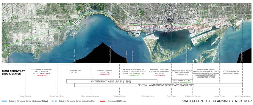
Waterfront Transit “Reset”
           Phase 1 Study

 Coordinated Transit Consultation Program
                        May 2016
        Transportation Planning Section | City Planning Division
                      Toronto Transit Commission
                          Waterfront Toronto

                         For more information and to provide further comment, please contact us at:
                                                                                 Waterfront Toronto
                                                                   Email: info@waterfronttoronto.ca
                                                                                      City of Toronto
                                                                 Email: waterfronttransit@toronto.ca
Why Are We Here Today?
The City, in partnership with the TTC and Waterfront Toronto, has initiated a
“Reset” of waterfront transit planning.
In the past, transit planning along the waterfront was incremental. This has left a series of transit plans
in various stages of approval.

&ROOHFWLYHO\WKHSODQVFDQQRWUHVSRQGWRWKHVLJQLÀFDQWFXUUHQWDQGIXWXUHDQWLFLSDWHGGHPDQGIRUWUDQVLWDORQJWKHZDWHUIURQW

                                                                                           2013                                       Current
                                                                                           City Planning’s “Feeling Congested?”       Coordinating with the emerging City-wide
                                                                                           2IÀFLDO3ODQ5HYLHZ preliminary transit    priority rapid transit network plan, 3KDVH
                                                                                                                                                                            Phase
                                                                                           QHWZRUNDQDO\VLVLGHQWLÀHVERWKWKH       1 of this Study will establish a clear
                                                                                           :DWHUIURQW:HVW/57DQG:DWHUIURQW        vision and
                                                                                                                                      vision  and evaluate   alternativealternative
                                                                                                                                                   identify reasonable   concepts
                                                                                           (DVW/LJKW5DLO7UDQVLW as within the      for a Waterfront
                                                                                                                                      concepts          Transit Solution.
                                                                                                                                                  for a Waterfront  Transit3KDVH
                                                                                           ´7RS3HUIRUPLQJ%XW8QIXQGHG            2VXEMHFWWR&LW\&RXQFLODSSURYDO
                                                                                                                                      Solution. Phase 2, subject to City Council
                                                                                           7UDQVLW3URMHFWVµ                         ZRXOGFRQWLQXHWRUHÀQHDQGDGYDQFHD
                                                                                                                                      approval,would continue to refine and
                                                                                                                                      Waterfront   Transit Solution.
                                                                                                                                      advance a Waterfront      Transit Solution.

                                                                                           2014 - Current                             2017
                                                                                          7KH&LW\0HWUROLQ[DQGWKH77&EHJLQ
                                                                                          The City, Metrolinx and the TTC begin       The Chief Planner & Executive Director,
                                                                                          integrated major transit network            City Planning will report to City Council
                                                                                          planning. Since then, planning work on      on an updated transit network plan
                                                                                          the Relief Line, SmartTrack/ Regional
                                                                                                                        Regional      (including a Waterfront Transit Solution)
                                                                                          ([SUHVV5DLO 5(5 DQG6FDUERURXJK
                                                                                          Express Rail (RER)  and Scarborough         as part of the proposed package of
                                                                                          7UDQVLWKDVDGYDQFHGFRQVLGHUDEO\
                                                                                          Transit Planning has advanced               transportation policy updates to the
                                                                                          considerably.                               2IÀFLDO3ODQ

Study Timeline
                                                                         Phase 1 (Current)                                                                   Phase 2
                                                                                                                                 June 28, 2016
 November 2015              Winter 2016              Spring 2016                                                                City Staff Report to        Summer 2016
                         Phase 1 Study Begins                                                      Spring – Summer 2016        Executive Committee
 City Council approves                               Development of             Today                                                                        Phase 1 Study
   Waterfront Transit      Coordination with      Evaluation Framework                                 Evaluation and             on Direction of
                                                                         Consultation on Phase                                                                 Concludes
    “Reset” Phase 1      Major Transit Planning    and Transit Network                               5HÀQHPHQWRI7UDQVLW      Phase 1 Study and
                                                                                1 Study                                                                    Council Direction for
         Study            Background Review             Concepts                                      Network Concepts         Recommendations for              Phase 2
                                                                                                                                  Phase 2 Study

                                                                                 Ongoing Consultation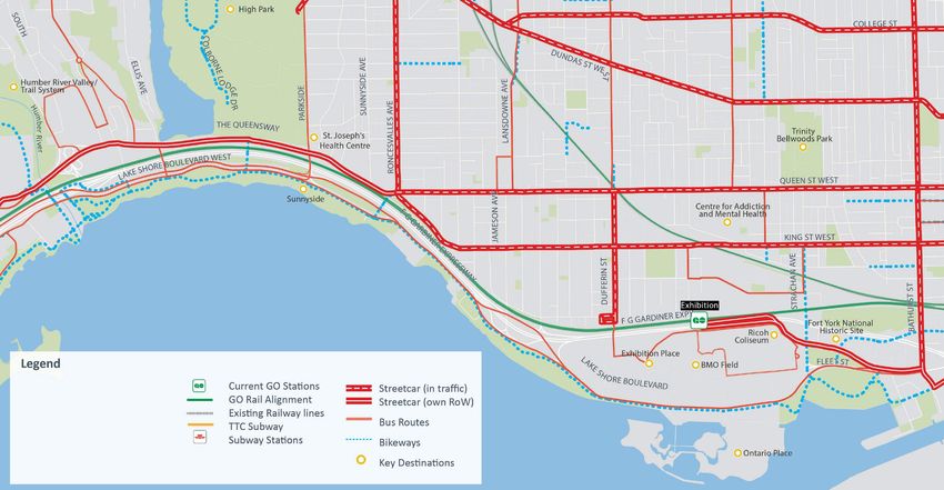
Draft Vision and Objectives
Draft Vision
  Provide high quality transit that will integrate
  waterfront communities, jobs, and destinations and
  link the waterfront to the broader City and regional
  transportation network
Draft Objectives
               1. Connect waterfront communities locally and to downtown with
                 reliable and convenient transit service:
                 •Promote and support residential and employment growth
                 •Provide more travel choices

               2. Enhance accessibility (improved reliability and convenience) of
                  transit service linking key destinations (employment, housing,
                  institutional, education, cultural, recreational, commercial):
                  • Better connect people to everyday places
                  • Improve connectivity in neighbourhood improvement areas
                  • Make transit an attractive option for more trips
                  • Attract new transit riders
                  • Improve quality of life

               3. Promote broader City and regional transportation network
                  connections

               4. Develop implementable and affordable solutions to address
                  current needs and the flexibility to respond to future conditions
What is the Purpose of this Meeting?
•• ToTointroduce
        introducethe   public to the
                    stakeholders   to study
                                      the study
•• To  provide background information on past transit initiatives along the waterfront
     7RSUHVHQWEDFNJURXQGLQIRUPDWLRQRQSDVWWUDQVLWLQLWLDWLYHVDORQJWKHZDWHUIURQWDQGRXU
   and   this study
     current  undertaking
•• ToTopresent   preliminary
        understand           concepts
                      your needs   and gather input on the opportunities and challenges of a
• To   understand
     Waterfront      your Solution
                  Transit needs and gather input on the opportunities and challenges of
 • aToWaterfront   Transit solution
        present preliminary    concepts
•• To  gather feedback on the initial screening of these concepts
     7RJDWKHUIHHGEDFNRQKRZWRHYDOXDWHWKHVHFRQFHSWV

Relevant Guiding Policies
Provincial and Regional Policies
                                                                       Places to Grow (Growth Plan for the Greater Golden Horseshoe)
                                                                       • Policies for fostering compact and complete communities
 Growth Plan
                                                                       • Emphasize the need to optimize the use of infrastructure, such as planned transit
                                                                       • 'RZQWRZQ7RURQWRLGHQWLÀHGDVDSULPDU\DUHDIRULQWHQVLÀFDWLRQDQGDQFKRUIRUWUDQVLW
 for the Greater Golden Horseshoe, 2006
 OFFICE CONSOLIDATION, JUNE 2013

                                                                         connections
                                          Ministry of Infrastructure

                                                                       The Big Move (Regional Transportation Plan)
                                                                       • 3ODQWREXLOGDFRPSUHKHQVLYHUHJLRQDOUDSLGWUDQVLWQHWZRUN
                                                                       • Policies for supporting the integration of transportation investment and land use

City Policies
                                                                       &LW\RI7RURQWR2IÀFLDO3ODQ
                                                                       • ,GHQWLÀHV¶$YHQXHV·DORQJ/DNHVKRUH%OYGLQ(WRELFRNHVHFWLRQVRI7KH4XHHQVZD\DQG
                                                                         .LQJ6WDQG4XHHQ6W
                                                                       • ¶$YHQXHV·FKDUDFWHUL]HGDVPDMRUVWUHHWVZKHUHUHXUEDQL]DWLRQFLW\EXLOGLQJDQGWKH
                                                                         FUHDWLRQRIYLEUDQWVWUHHWVFDSHVDUHHQFRXUDJHG

                                                                       Central Waterfront Secondary Plan
                                                                       )UDPHZRUNIRUWKHUHQHZDOWKHFHQWUDOZDWHUIURQWE\
                                                                       • Improving connections including developing a Waterfront transit network
                                                                       • Supporting the development of complete communities
                                                                       • Guiding on-going precinct planning (i.e. East Bayfront, Port Lands precinct plans)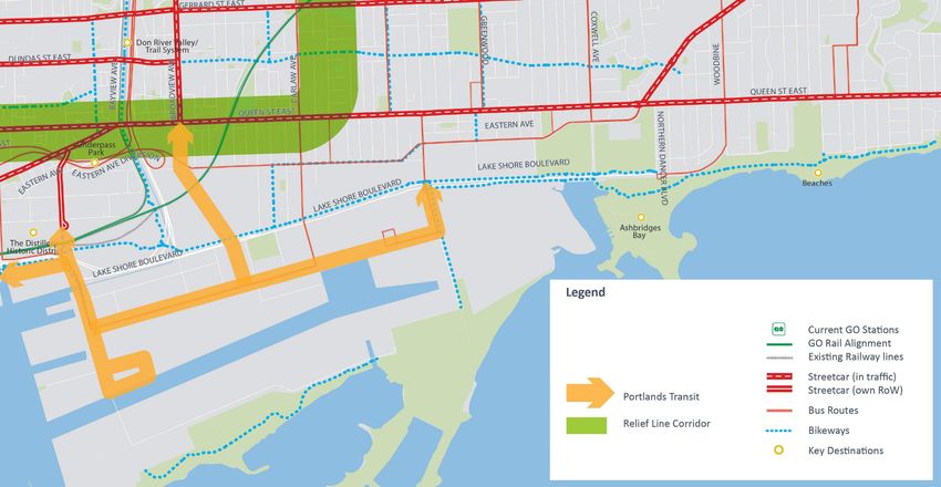
Relevant Guiding Policies
City Policies
Strong Neighbourhoods Strategy 2020
Strategy support equity and vitality in all areas of the City
• Directs investments in priority neighbourhoods (Neighbourhood Improvement Areas)
• Identifies one NIA in the study area: South Parkdale
Feeling Congested? Projects not
Comprehensive consultation process to develop draft
The table on this page Projects in the BIG MOVE Regional Transportation Plan In the big move
RAPID TRANSIT
RAPID TRANSIT
NO Project Name ASSUMED ROute Length Completed illustrates how each rapid
Technology by transit project under Next Wave Others OP Map 4 Others
transportation policies for updating the City’s Official
I Highway 427 Airport BRT South BRT 10km N/A consideration scores against A B C D E F G H I J K L M N O P Q R S T U V W X
each weighted critera. In
J Highway 427 Airport BRT North BRT 12.5km N/A
Relief Line Extension (Danforth to Eglinton)
Bloor-Danforth Subway West Extension
other words, the score you
K Jane LRT
Plan in 2017
LRT 16.5km (14.5km in Toronto + 2km in York) N/A see is for a scenario in which
the corresponding criteria is
Relief Line (Downtown to Danforth)
St. Clair Streetcar/LRT Extension
Highway 427 Airport BRT South
Highway 427 Airport BRT North
Yonge North Subway Extension
Finch West LRT West Extension
Scarborough RT/LRT Extension
Finch West LRT East Extension
L McCowan Road BRT BRT 15km (6.5km in Toronto + 8.5km in York) N/A
Sheppard East LRT Extension
weighted more heavily than
Eglinton LRT West Extension
Durham-Scarborough BRT
Scarborough Malvern LRT
M Scarborough RT/LRT Extension LRT 3.3km N/A the others. How does each
Sheppard West Corridor
project score against your
Steeles LRT/BRT West
Steeles LRT/BRT East
N Scarborough Malvern LRT LRT 13.3km N/A
Waterfront West LRT
McCowan Road BRT
Waterfront East LRT
Kingston Road BRT
preferred criteria? Notice that
Includes a comprehensive evaluation of the City’s Dundas Street BRT
O Sheppard East LRT Extension LRT 2.4km N/A some rapid transit projects
Don Mills LRT
P Steeles LRT/BRT West LRT/BRT 17.0km N/A perform consistently well
Jane LRT
across all criteria.
rapid transit projects
Q Steeles LRT/BRT East LRT/BRT 21.5 km (11km in Toronto + 10.5km in Durham) N/A
R Waterfront West LRT LRT 16.5km (22.0km) EVALUATION CRITERIA N/A
TORONTO OFFICIAL PLAN MAP 4 — HIGHER ORDER TRANSIT ROUTES CHOICE
S Bloor-Danforth Subway West Extension SUBWAY 3.5km N/A EXPERIENCE
T Kingston Road BRT BRT 9km N/A SOCIAL EQUITY
U Sheppard West Corridor SUBWAY 4km N/A SHAPING THE CITY
V Waterfront East LRT LRT 5.5km N/A HEALTHY NEIGHBOURHOODS
OTHER CITY OF TORONTO PROJECTS PUBLIC HEALTH &
Relief Line East Extension THE ENVIRONMENT
W SUBWAY 5km N/A
(Danforth to Eglinton) AFFORDABILITY
X St. Clair Streetcar/LRT Extension LRT 1.5km N/A
SUPPORTS GROWTH
ALL CRITERIA EQUALLY WEIGHTED
13 Very Low Score Low Score Moderate Score High score Very high score
14
Ongoing Major Studies
TOcore: Secondary Plan for Downtown
Developing a renewed strategic vision for the Downtown:
• Prioritizes walking, cycling, surface transit
• Guides complementary studies including King Street Visioning Study, surface transit
operational improvements
Port Lands and South of Eastern Transportation and Servicing Master Plan
• Study to develop an integrated transportation and servicing plan to inform the revitalization
needs of the Port Lands area
• Plan to include confirming transit corridors, major streets, and servicing needs to support
development
Park Lawn/Lake Shore Area Transportation Master Plan
• Study to develop an integrated multi-modal transportation plan that brings together
previously planned and approved infrastructure projects, development plans,
infrastructure opportunities, and community needs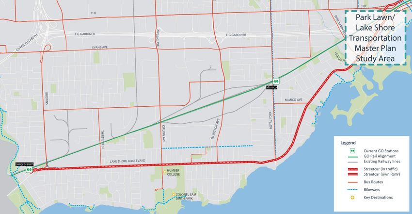
01
  SEGMENT
  Existing Transportation
                         Long Branch to Humber River

                                                                                                                        Mr. Christie’s site offers potential
                                                                                                                       redevelopment and transportation
                                Opportunities for faster, more reliable                                                          hub opportunity
                                 transit connections locally and to
                                             downtown

                                                                                              Potential GO station sites

                                                                                                                                                                                  Recent and
                          Opportunities to capture more transit                                                                                                               planned residential
                            riders north and to Mississauga                                                                                                                   growth in Humber
                                                                                                                                                                                 Bay Shores

                                                                                                                                                                      Narrow
                                                                                                                                                                      Corridor
   Opportunities for better interconnections
    with planned Regional Express Rail

                                                                                                         Express buses along Lake Shore
                                                                                                        Blvd (to Downtown) and Kipling (to
                                                                                                                    Subway)

                                                                                                                                    Sources: TTC, Metrolinx, City of Toronto, and Gov't of Ontario

 Current Travel Patterns

                                                  Internal Travel                    To/from                  To/from central                     To/from                        To/from all
                                                                                   Downtown core                 Etobicoke                       Mississauga                     other areas
    Percentage of total trips
     within AM Peak Period                             15%                                  12%                    14%                              16%                              43%
 Percentage of transit trips in
      AM Peak Period                                   12%                                  56%                    13%                               9%                              28%
Source: 2011 Transportation Tomorrow Survey                                    Opportunity to support      Opportunity to foster growth in transit ridership
                                                                               existing demand
 Land Use
           Regional shopping centre and
               hospital destinations

                                                                                                                                                                        Humber Bay Park a
            High-density residential with
                                                                                                                                                                      recreation destination
             potential for more growth

                           Existing industrial
                           employment uses

                                 Growing Humber
                                 College campus
                                                                                                                                              Higher density growth

                                                     Higher-density growth in Port Credit
                                                     and planned in Inspiration Lakeview                       Designated as ‘Avenue’ where
                                                                                                               reurbanization is encouraged

                                                                                                                                                 Source: Toronto Official Plan, Land Use Plan, 2015

                                                                                                                                                                                                      1
01
SEGMENT
           Long Branch to Humber River
Population and Employment Growth

                                                                            Segment 1
                                                                                                 Source: City of Toronto
                 100,000

                   80,000                    + 18,025
                   60,000

                   40,000
                                                                              + 9,005
                   20,000

                       -
                                         Pop                            Emp
                                                  Projected Change
                                                                       2011        2041

Opportunities and Constraints
 •   Population growth in Mimico and Humber Bay Shores has led to a significant increase in travel
     demand
 •   Streetcar service operating along Lake Shore Blvd in mixed traffic, leads to less reliable service and
     longer trip times
 •   Potential to capture new transit riders with improved service to north Etobicoke and to Mississauga
 •   Opportunities for faster and more reliable transit connections to and from the Downtown core
 •   Opportunities for improved interconnections with planned Regional Express Rail services along the
     GO Lakeshore West corridor
 •   Redevelopment of the Mr. Christie’s site presents a potential transportation hub opportunity,
     including a new GO station
 •   Queensway corridor redevelopment presents a potential transit market

                                                                                                                           2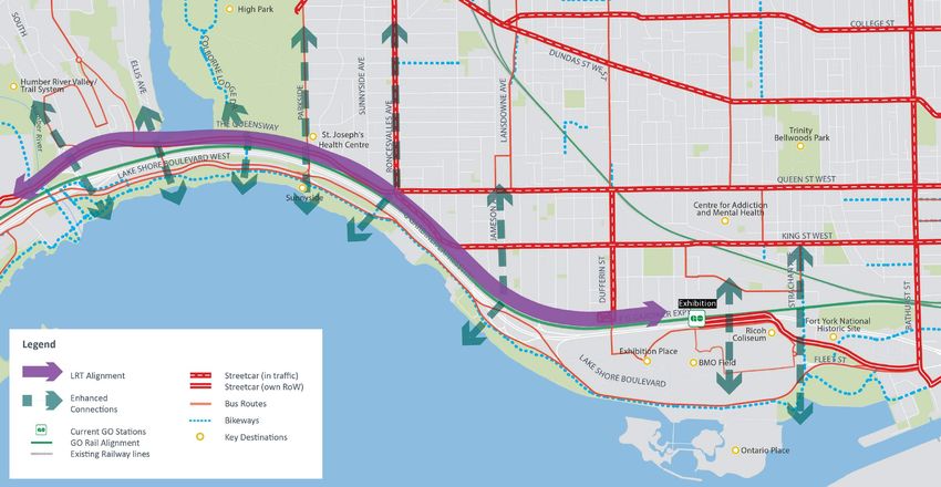
02
SEGMENT
  Existing Transportation
                         Humber River to Strachan Ave

                                                                                                      Need for greater capacity and reliable east-
                                                                                                                west travel alternatives

                      Improve access to waterfront parks                                 Potential GO station sites
                                 and trails

                                                                          Need to respond to
                                                                        changing travel in high
                                                                       growth areas (e.g. Liberty
                                                                               Village)

                                                                                                       Opportunities to provide access to
                                                                                                         Exhibition Place and planned
                                                                                                         Ontario Place redevelopment

Current Travel Patterns
                                                                                                                               Sources: TTC, Metrolinx, City of Toronto, and Gov't of Ontario

                                              Internal Travel                 To/from                        To/from south              To/from areas                  To/from all
                                                                            Downtown core                      Etobicoke                    north                      other areas
    Percentage of total trips
     within AM Peak Period                           6%                           30%                            3%                      14%                            47%
 Percentage of transit trips in
      AM Peak Period                               14%                            49%                           36%                      31%                            36%
Source: 2011 Transportation Tomorrow Survey                              Opportunity to support                                  Opportunity to foster

Land Use                                                                   existing demand                                         growth in transit
                                                                                                                                      ridership

                                                 HIGH PARK
                                                                                                                       Designated as ‘Avenue’ where
                                                                                                                       reurbanization is encouraged

                                                                                                                                                   High-density
                                                                                                                                                 residential growth
                                                             Limited access to the
                                                           waterfront parks and trails

                                                  Neighbourhood Improvement Area (NIA)

                                                 Increased visitors at Exhibition Place with recent
                                                 sports facility expansion, hotel development and
                                                                     future vision

                                                                                         Potential redevelopment at
                                                                                               Ontario Place                                    Potential employment
                                                                                                                                                    area growth

                                                                                                                          Source: Toronto Official Plan, Land Use Plan, 2015

                                                                                                                                                                                                3
02
SEGMENT
            Humber River to Strachan Ave
Changes in Population and Employment by 2041

                                                                           Segment 2
                                                                                                Source: City of Toronto
                 100,000
                                             + 25,650
                  80,000

                  60,000

                  40,000
                                                                           + 10,635
                  20,000

                       -
                                         Pop                            Emp
                                                  Projected Change
                                                                       2011       2041

Opportunities and Constraints
•   Need for greater capacity and reliable east-west transit alternatives from Roncesvalles Village, South
    Parkdale, and King-Liberty to Downtown core
•   Opportunities to provide greater transit options in Liberty Village, which has experienced notable
    residential and employment growth
•   Ontario Place potential revitalization may require high quality transit service
•   Opportunities to provide better connections to Exhibition Place with more events
•   Crowds flowing through Exhibition Place to attend sports and seasonal events (CNE) may limit
    alignments centrally through the Exhibition Place site
•   Opportunities for greater access to waterfront parks and trails
•   Rail corridor, Gardiner Expressway, and significant grade changes are barriers to access waterfront
    parks and trails

                                                                                                                          4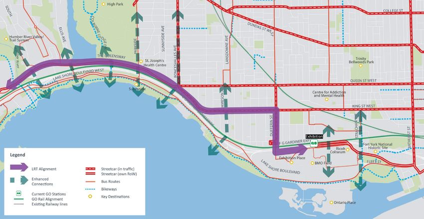
03
SEGMENT
Existing Transportation
                           Strachan Ave to Parliament St

                                                                                                                                 Limited streetcar capacity at
                                                                                                                                  current Union Station loop

                        Opportunities for short-term
                          transit improvements                                                                                                 Significant cost to
                                                                                                                                                 expand loop +
                                                                                                                                             substantial construction
                                                                                                                                                    impacts

                                                                                                                                         Accommodate emerging
                                                                                                                                         growth in East Bayfront
                                                                                                                                             and Port Lands

                                                          Need to respond to
                                                        changing travel in high
                                                        growth areas (e.g. City
                                                        Place, Fort York area)

Current Travel Patterns
                                                                                                                 Sources: TTC, Metrolinx, City of Toronto, and Gov't of Ontario

                                                                       To/from the west      To/from south               To/from area
                                              Internal Travel                                                          east (Port Lands,                 To/from all
                                                                      (up to the Humber       and central
                                                                             River)            Etobicoke                Queen St. East)                  other areas
    Percentage of total trips
     within AM Peak Period                             12%                        4%                 4%                          2%                          78%
 Percentage of transit trips in
      AM Peak Period                                   27%                    49%                  60%                           41%                         69%
Source: 2011 Transportation Tomorrow Survey                                                                              Number of trips

Land Use
                                                                                                                      expected to grow with
                                                                                                                      planned development

                                                                                                    Further development in the
                                                                                                         Financial District                      Emerging West Don Lands
                                                                                                                                                  mixed-use community

        Project: Under Gardiner
        proposes new parks and
             public spaces

         High-density residential
                growth
                                                                                                                 Redevelopment in East Bayfront precinct underway, including
      Significant improvements to                                                         Emerging South Core          Corus Quay, Sugar Beach, Sherbourne Common
      make central waterfront area                                                           office district
        a celebrated destination

                                                                                                                            Source: Toronto Official Plan, Land Use Plan, 2015

                                                                                                                                                                                  5
03
SEGMENT
Strachan Ave to Parliament St
Changes in Population and Employment by 2041
Segment 3 Source: City of Toronto
600,000
500,000 + 138,380
400,000
300,000 + 200,385
200,000
100,000
-
Pop Emp
Projected Change
2011 2041
Opportunities and Constraints
• Need for greater transit connections to serve the significant levels of redevelopment already occurred
and planned, including near Fort York, Cityplace, Entertainment District, South Core and East Bayfront
• Limited streetcar capacity at the current Union Station loop
• New streetcar connections to the Union Station loop will require significant infrastructure costs and
construction disruptions
• Various concepts in the Downtown Core are presented:
• “Status quo”: modify existing loop to accommodate future transit demand
• “Transit-first” network: rethink approach with an extended transit surface network,
linking the city to the waterfront
604
SEGMENT
Existing Transportation
Parliament St to Woodbine Ave
Existing Kingston Loop
Opportunities to provide
additional connections
east-west to Downtown
core
Port Lands Master Plan identifies higher order
transit corridors
Current Travel Patterns
Sources: TTC, Metrolinx, City of Toronto, and Gov't of Ontario
To/from To/from areas To/from areas in To/from all
Internal Travel Downtown core north (up to Don farther west (south
Valley) Etobicoke, High Park, other areas
King-Liberty)
Percentage of total trips
within AM Peak Period 8% 23% 19% 3% 46%
Percentage of transit trips in
AM Peak Period 1% 41% 14% 39% 20%
Source: 2011 Transportation Tomorrow Survey Opportunity to grow Opportunity to support Opportunity to foster
Land Use
ridership with increased existing demand growth in transit ridership
development
Early planning for
redevelopment of First Gulf
site
Existing industrial
employment uses
Flood protection required to
facilitate full development in the
Port Lands
Ashbridges Bay Park and
beach a main destination
Currently utilized for industrial land
uses, with plans as secondary
Area part of Port Lands and South of Tommy Thompson Park a
downtown with greater concentration
Eastern Transportation and Servicing key destination
of employment
Master Plan
Source: Toronto Official Plan, Land Use Plan, 2015
704
SEGMENT
Parliament St to Woodbine Ave
Changes in Population and Employment by 2041
Segment 4Source: City of Toronto
80,000
70,000
+ 33,825
60,000
50,000
+ 32,075
40,000
30,000
20,000
10,000
-
Pop Emp
Projected Change
2011 2041
Opportunities and Constraints
• Opportunities to increase transit connections east of Leslie Street to the Downtown core
• Current form of the Gardiner Expressway, Lake Shore Blvd, and water features are barriers
to connect city to Port Lands
• Building on the Port Lands Master Plan already in progress, higher-order transit will
support the development of a new walkable mixed-use community
801
SEGMENT
Concepts: Long Branch to Humber River
Concept 1A: Enhance Lake Shore
• Improve Lake Shore streetcar
operations, potentially utilizing,
but not limited to: Lake Shore
left turn restrictions, north-south
roadway turning restrictions,
transit signal priority, reduced
number of stops, etc
• Provide better connections to GO
stations and MiWay, including
more convenient direct transfers
and improved cycling and
pedestrian environment
• Improve the north-south bus
service, as required to address
future transit demands and to
connect to the broader City and
regional network
Concept 1B: Lake Shore Blvd. LRT
• Reconfigure existing streetcar
line to LRT, that will be
generally separated from
traffic lanes but with fewer
stops
• Provide better connections
to GO stations and MiWay,
including more convenient
direct transfers and improved
cycling and pedestrian
environment
• Improve the north-south bus
service, as required to address
future transit demands and
to connect to the broader City
and regional network
Concept 1C: The Queensway LRT
• Introduce a LRT alignment
along the Queensway
corridor, that will be generally
separated from traffic lanes
• Like Concept 1A, enhance
Lake Shore streetcar service
to support access to the
Queensway LRT and GO Rail.
• Better connections and
improved bus service could
be considered
902
SEGMENT
Concepts: Humber River to Strachan Ave
Concept 2A: Complete the Missing Link
• Extend LRT from the existing
Exhibition Loop westerly along
the south side of the Gardiner
and rail corridors
• Cross the Gardiner and rail
corridors to connect with
the existing Queensway LRT
alignment at a signalized
intersection at Sunnyside Ave
• Adjust transit routes by
turning back existing 501
Queen streetcar service at the
Sunnyside Loop to improve
east-west capacity
Concept 2B: Former Front Street Extension
• Introduce a LRT line westerly
along the north side of the
rail corridor, connecting with
the existing Queensway LRT
alignment at a signalized
intersection at Sunnyside Ave
• Adjust transit routes by
turning back existing 501
Queen streetcar service at the
Sunnyside Loop to improve
east-west capacity
Concept 2C: Lake Shore Blvd LRT
• Extend LRT from the
existing Exhibition Loop
westerly within the Lake
Shore corridor
• Cross the Humber River
adjacent to the Gardiner
eastbound on-ramp,
connecting to Lake Shore
Blvd West
1002
SEGMENT
Concepts: Humber River to Strachan Ave
Concept 2D: Lake Shore Blvd LRT to Exhibition
• Extend LRT from the existing
Exhibition Loop westerly
within the Lake Shore
corridor
• Cross the Humber River
adjacent to the Gardiner
eastbound on-ramp,
connecting to Lake Shore
Blvd West
Concept 2E: Lake Shore Blvd LRT/Colborne Lodge Dr
• Extend LRT from the existing
Exhibition Loop westerly
within the Lake Shore
corridor
• Connect with the existing
Queensway LRT alignment
using Colborne Lodge Drive
Concept 2F: Dufferin St / King St
• Extend LRT from the existing
Exhibition Loop westerly to
Dufferin St
• Continue northerly along
Dufferin St, potentially
separated from traffic lanes, to
King St
• Easterly along the existing King
streetcar line, with potential
operational enhancements
(such as left turn restrictions,
transit signal priority reviews,
removal of stops, etc.)
• Connect with the existing
Queensway LRT alignment
at the King St/ Queen St/
Roncesvalles Ave/ Queensway
intersection
1103
SEGMENT
Concepts: Strachan Ave to Parliament St
Concept 3A: Existing Fleet St Alignment
• Upgrade the existing Fleet LRT corridor from the
Exhibition Loop, to address transit and traffic
operational issues, particularly in the vicinity
of the Fleet St/ Lake Shore Blvd/ Bathurst St
intersection
• Easterly concept alternatives are presented
from the Fleet St/ Lake Shore Blvd/ Bathurst St
intersection – serving Downtown concepts
Concept 3B: Fort York Blvd - Bremner Blvd
• Introduce a LRT line from the existing Fleet LRT
corridor from the Exhibition Loop, northerly along
Fort York Blvd to Bathurst St
• Continue easterly along the Fort York – Bremner
corridor, crossing Bathurst St and Spadina Ave
• Along Bremner Blvd and east of Lower Simcoe St,
enter a portal to go underground and continue
easterly underground to connect with an expanded
Union Loop
Concept 3C: Former Front St Extension
• Introduce a LRT line easterly along the north side of
the rail corridor, crossing underground the Kitchener
GO Rail corridor to connect with the Bathurst St /
Front St intersection
• Easterly concept alternatives are presented from the
Bathurst St / Front St intersection – refer to serving
Downtown area concepts
Concept 3D: Lake Shore Blvd LRT
• Introduce a LRT line along the Lake Shore corridor
easterly from south of Exhibition Place and
Coronation Park
• Connect with Queens Quay west of Bathurst St,
with mixed traffic operations within the Bathurst
Quay Neighbourhood
1203
SEGMENT
A
Concepts for Serving Downtown
B C D
Union Loop Queens Quay Network
Second Loop
Modification Through Service Distribution
• Considerable redesign • Build a 2nd terminus • Route service along • Route service along the
of Existing Union Loop west of Union, with Queens Quay with network using:
either by: connections to different configurations • Existing alignments
• Expanding current • Requires enhanced • New alignments
Loop regional transit and to
• Extending alignment serve western demand north-south transit
easterly
A1: Expanded Union Loop
• As per approved East Bayfront Transit EA,
expand existing Union Loop to increase station
capacity and to improve terminus operations
(i.e. new platforms, additional by-pass and
crossover trackage)
• Includes the potential to implement the
Bremner Blvd route as originally envisioned
• Through service along Queens Quay will be
provided by a new tunnel as per the approved
East Bayfront Transit EA
A2: Extend Underground Alignment Easterly
• Eliminate Union Loop by extending the
Existing Union
Loop
Repurposed
existing Queens Quay LRT easterly under the
rail corridor or in the adjacent development,
creating an in-line station on a continuous route
Potential
Bremner LRT
Freeland St
B1: Second Loop
• Construct a second downtown terminus loop,
likely on the west side of Union Station
• Maintain existing Union Loop, limiting
operations to its existing capacity
• Includes the potential to implement the
Bremner route, however likely not as originally
envisioned
• Through service along Queens Quay will be
provided by a new tunnel as per the approved
East Bayfront Transit EA
1303
SEGMENT
Concepts for Serving Downtown
C1: Tunnel By-Pass
• Maintain existing Union Loop, limiting
operations to its existing capacity
• Through service along Queens Quay will be
provided by a new tunnel as per the approved
East Bayfront Transit EA (potentially extended
to provide an underground station for
access to the ferry terminal - consistent with
Alternative Q3 from the EA)
• New terminal loop required in the east
C2: Tunnel By-Pass, Repurpose Bay St Tunnel
• Existing Union Loop and Bay Tunnel are re-
purposed for pedestrian use
• Enhanced Bay bus service provided to Queens
Quay (such as reserved bus lanes)
• Through service along Queens Quay will be
provided by extending the existing LRT easterly
in a tunnel under Bay, emerging east of Yonge
St
• New terminal loop required in the east
C3: At-Grade By-Pass
• Maintain existing Union Loop, limiting operations
to its existing capacity
• Through service along Queens Quay will be
provided by splitting off a separate LRT line in the
vicinity of York St in order to avoid the existing
portal and underground service to the Union Loop
• Mixed traffic operations within the Queens Quay
roadway will result between York St and Yonge St,
prior to connecting to the approved East Bayfront
LRT alignment New terminal loop required in the
east
C4: At-Grade By-Pass and Repurpose Bay St Tunnel
• Existing Union Loop and Bay Tunnel are re-
purposed for pedestrian use
• Enhanced Bay bus service provided to Queens
Quay (such as reserved bus lanes)
• Through service along Queens Quay will be
provided by extending the existing LRT easterly
at-grade over existing Queens Quay portal
• New terminal loop required in the east
1403
SEGMENT
Concepts for Serving Downtown
D1: Distribute On Network & Use Existing Loop
• Transit service from the east and west will be
distributed and looped over upgraded LRT
corridors
• Maintain existing Union Loop, limiting
operations to its existing capacity
• Through service along Queens Quay will be
provided by a new tunnel as per the approved
East Bayfront Transit EA (potentially extended
to provide an underground station for
access to the ferry terminal - consistent with
Alternative Q3 from the EA)
• New terminal loop required in the east
D2: Distribute On Network & Bay St LRT
• Existing Union Loop and Bay Tunnel are re-
purposed for pedestrian use
• Introduce semi-exclusive transit corridor along
Bay Street potentially linking with the Relief
Line
• Through service on Queens Quay provided at-
grade
• New terminal loop required in the east
D3: Bay St LRT
• Existing Union Loop and Bay Tunnel are re-
purposed for pedestrian use
• Introduce semi-exclusive transit corridor along
Bay Street potentially linking with the Relief
Line
• Through service on Queens Quay provided at
grade
• New terminal loop required in the east
1504
SEGMENT
Concepts: Parliament St to Woodbine Ave
Proposed transit network between Parliament St and Leslie Ave is based on
adopting the work being completed for the Port Lands Transportation and
Servicing Master Plan. Conceptual options are only being considered from
Leslie Ave to Woodbine Ave.
Concept 4A: Lake Shore Blvd Corridor
• Extend proposed
Commissioners LRT, as being
proposed from the Port Lands
Transportation and Servicing
Master Plan EA, from Leslie St
easterly along the Lake Shore
corridor to connect with the
existing Queen streetcar
Concept 4B: Eastern Ave Corridor
• Extend proposed
Commissioners LRT, as being
proposed from the Port Lands
Transportation and Servicing
Master Plan EA, northerly along
Leslie St to Eastern Ave, and
then easterly along Eastern
Ave to connect with the existing
Queen streetcar
16You can also read