Postal History Journal - American Philatelic Congress
←
→
Page content transcription
If your browser does not render page correctly, please read the page content below
Postal
                                                 History
                                                 Journal
                                             NUMBER 170                                           JUNE 2018
POSTAL HISTORY JOURNAL, NO. 170, JUNE 2018

                                              Natchez Trace * Mail for Los Alamos WWII * A Remington in Paris

                                             Eastman FDCs * 1881 USPOD Contractor * African Relief Expedition
• Complete album with 25 pages (page                     • Complete album with 25 pages (Page
  size 87/8x9”) Available in: Blue, Black,               Size 87/8x9”) (Available in: Blue, Black,
  Wine Red                                               Wine Red)
• Black back two sided 2 pocket pages                    • Black-back two-sided 2 pocket pages
  (holds 100 180x108mm covers)                             (holds 100 248x140mm covers)
  ZGK-838A $27.07, SSS Price $20.30                        ZGK-836A $27.07, Price $20.30

• Same with all-clear pages (holds 100                   • Same with all-clear pages (holds 100
covers or 50 viewed from both sides)                     covers or 50 viewed from both sides)
  ZGK-838AC $27.07, SSS Price $20.30                       ZGK-836AC $27.07, Price $20.30

 108mm
                                                            108mm

 108mm                                                      108mm

                       183mm
                                                                                        154mm

                   Neil,
 Edited by Ada Prill                                     By Richard C. Frajola,
 (2006)                                                  Philatelic Foundation
Completely revised and                                   Publisher: Philatelic
 expanded to include                                     Foundation (2005) 165
 new           exhibiting                                pages
 catagories and rules of
 exhibiting.                                             RPF02 $45.00
 RRN-01 $39.99 SSS Price $31.99                            SSS Price $36.00
         A MUST HAVE BOOK!!

                                                                                               Not Responsible For
                                                                                               Typographical Errors

      By MAIL/UPS *: $6.50 Min. Orders over $55 ADD 12%, Over $100 ADD 10%, Over $250 ADD 8%
          * Some Remote Areas Carry Higher Shipping charges. PA Residents: ADD 6% Sales Tax
              ADD $5/$10 Per Parcel on high weight/low cost orders shipped to the 11 Western States & TX
                        Ask for Shipping Charges to AK, HI, P.R., APO’s, FPO’s, Foreign
                                   1-800-221-9960               1-888-221-9960
Now is the right time to consider
selling your specialized collection.
                            Kelleher
                            is proud
                             to have
                            countless
                          bidders and
                            buyers in
                               every
                      conceivable philatelic
                      specialty throughout
                    the world—you name it.
                       here s no be er place
                          to sell your
                           specialized
                           collection.
                            Count on
                            Kelleher
                          to help you.

     uite fran ly there is no be er source in the
 world for every form of worldwide postal history.
   And because of this—as one might expect—
   there is no be er venue in the world for you
when it comes time to sell your cherished collection.

                       Daniel F. Kelleher Auctions, LLC
              America’s Oldest Philatelic Auction House • Established 1885
                            60 Newtown Road., PMB #44
                              Danbury, CT 06810 USA
                         +203.297.6056 • Fax: +203.297.6059
                   info@kelleherauctions.com
              www.kelleherauctions.com
Postal History Journal
           Postal History Journal
      Published by the Postal History Society
                     APS Affiliate No. 44
       Published
            issued by     the Postal
                      February,        History
                                    June,        Society
                                            October.
                    APS    Affiliate   No.
  Annual dues $35 U.S., $40 Canada & Mexico44
 $50 restissued
             of world February,
                          (or $15June,    October. journal,
                                     for electronic
  Annual dues $35 U.S., $40 Canada & Mexico
           special to non U.S. members only)
 $50 rest of world (or $15 for electronic journal,
   P.O. Box 468101, Atlanta GA 31146, U.S.A.
           special to non U.S. members only)
              www.postalhistorysociety.org
    P.O. Box 468101, Atlanta GA 31146, U.S.A.
For this journal, the editors have been awarded the American Philatelic Congress Diane D. Boehret Award
              www.postalhistorysociety.org
2014; Reserve Grand Stampshow 2015; gold medals Napex 2009, Colopex 2007, Chicagopex 2015, APS
 For this journal,
Stampshow     2015.the editors have been awarded the American Philatelic Congress Diane D. Boehret Award
Stampshow 2017.
 2014; Reserve Grand Stampshow 2015; gold medals Napex 2009, Colopex 2007, Chicagopex 2015, APS
 Stampshow 2015.
NUMBER          167                             ISSN 0032-5341                                    JUNE 2017
  NUMBER
 NUMBER
Editors:        170
                167
            Diane  DeBlois & Robert Dalton              ISSN
                                                       ISSN        0032-5341
                                                                  0032-5341
                                                             Harris,      P.O. Box 477, West Sand Lake                     JUNE
                                                                                                                            JUNE       2018
                                                                                                                               NY 12196, 2017
   U.S.A.
 Editors: Diane DeBlois & Robert Dalton Harris, P.O. Box 477, West Sand Lake NY 12196,
Editorial    Board: Yamil H. Kouri; Roger P. Quinby; Stephen S. Washburne; &
   U.S.A.
   U.S. Associate
 Editorial            Yamil H.Kenneth
             Board: Editor:         Kouri; Roger  Grant,P. E11960
                                                              Quinby; KesslerStephenRd.,         Baraboo WI
                                                                                          S. Washburne;            & 53913
   U.S.  Associate Editor: Kenneth Grant, E11960 Kessler Rd., Baraboo WI 53913
      570, Washington
   Foreign                  DC 20013-7012
              Associate Editor:        Daniel Piazza,
                                                                National Postal Museum, P.O. Box 37012 MRC
                                                 CONTENTS copyright 2018
      570, Washington
   Advertising     Manager:DC 20013-7012
                                   Michael Mead
Revisiting the Natchez Trace:
Development of a Postal Route Paradigm for the United States
                  By Diane DeBlois & Robert Dalton Harris
                              Buffalo Tract to National Road
      Natchez, above New Orleans on the Mississippi River, had become a strategic site be-
fore the Louisiana Purchase of 1803 charged the speculative geography of America, at the
same time as it challenged the architecture of its postal system.1 To look more closely, we
start with the best book available in the Natchez Trace visitors’ center at Tupelo, Mississippi.
The Natchez Trace, A Pictorial History, by James A. Crutchfield,
Territorial Press, Franklin TN, 1985, revised 2011 ISBN
978-0-944275-15-3. 160 pages, perfect bound. 9 chapters + Bib-
liography + Index.

     The Natchez Trace was first cut by the migration of
big animals from the Mississippi River bottom to the up-
land prairies and salt licks of what is now central Ten-
nessee and Kentucky. James A. Crutchfield’s history is
deeply cut, too: the National Park founded along this route
eighty years ago features a post rider in its logo (Figure 1) Figure 1: Why would a
                                                              National Park have a post
which graces the front endpaper, but the mail doesn’t arrive rider as its logo?
on the Trace until the seventh chapter.

“The official emblem of the Natchez Trace Parkway is a silhouette of a post rider on horseback.
The old Trace, during a great portion of its later use by Americans, served as a post road con-
necting Nashville and Natchez. As such, it was a vital communication link between the lower
Mississippi valley and the settlements in the East.”

     Crutchfield gives his material nine chapters, each fronted with a topological abstract
upon an outline map, accompanied by an overarching narrative of three pages, and anoth-
er dozen pages given to illustrations - each image captioned with a careful reading.

1. The Natural Setting. The Trace, from Nashville on the Cumberland River, bears
   450 miles southwestward across the central basin of Tennessee and the Tennessee
   River into northwestern Alabama and the prairie watershed of the Tombigbee River
   (which debouches to Mobile Bay). Transiting the red clay hills of central Mississip-
   pi, the Trace finally descends and cuts into the fertile loess hills of the Yazoo River
   valley and Mississippi bottom to Natchez.
2. The Prehistoric Trace. The topological features of this chapter’s map show the
   archaeological sites bracketing the route. Indians had lived in the region perhaps
   10,000 years with distinguishing cultural practices: paleo, archaic, woodland, - and
   climaxing with the Mississippian mound builders and traders, a most northern pen-
   etration of Aztecan influence.

Postal History Journal No. 170              June 2018                                    Page 2
3. Indian Trails. Fragmentation of the Mississippian culture is represented by three
   ‘historic’ tribes that claimed land astride the Trace. From south to north: the
   Natchez, the Choctaw, and the Chickasaw, speaking the same language.
4. European Contact in the South. Given the Indian occupation of the land, the in-
   surgence of settlers began with Europeans and ended with Anglo-Americans. Her-
   nando De Soto, crossing the Trace on his way to discovering the Mississippi River
   in 1541, fought the Chickasaws. The earliest penetrations of the area of Natchez by
   France resulted in a trading post and then a fort. In 1729, the Natchez attacked the
   fort and the France retaliated with a massacre, scattering the survivors. Subsequent-
   ly, in 1736 at Ackia the French, joined by Choctaws against their traditional ene-
   mies, were badly beaten by the Chickasaws, “proving to be the turning point of
   French influence in the Mississippi River valley.” British occupation of a fort at
   Natchez was succeeded by the Spanish in 1781.
5. American Settlement in the North. Following the Revolutionary War, Americans
   disputed Spanish claims to the Natchez which was resolved by an evacuation by the
   Spanish in time for the formation of the Mississippi Territory in 1798. At the north-
   ern end of the Trace where a trading post had been abandoned in 1714, Nashville
   congealed in 1780 out of Transylvania, a huge purchase of Cherokee lands in 1775.
   Negotiations beginning in 1783 subsequently freed the land between the Cumber-
   land and the Duck Rivers for White settlement.
6. The Boatmen’s Trail. The new settlers in the Ohio, Cumberland, and Tennessee
   drainages rafted their goods to the Mississippi and down river markets in Natchez
   (Figure 2) and New Orleans. Swelling in numbers from the 1780s until the advent
   of steamboats, these boatmen walked back home, with as many of their lives and as
   much of their money as could survive the Natchez “under the hill” (Figure 3) and
   the vicissitudes of the way.

 “King’s Tavern, located at the beginning of the Natchez Trace, is one of the oldest structures
 still standing in Natchez. The land and building were granted to Prosper King by the Spanish
 authorities in 1789, and from that date until 1820 the property was operated as a tavern. The
 long journey up the Natchez Trace, with the dangers of outlaws, often led travelers to group
 together for protection, and King’s Tavern was used as a gathering place for these individuals
 and parties ready to make the trip. The first United States mail ever delivered from Nashville
 to Natchez was first brought to King’s Tavern for distribution to the town’s citizens.”

                                                  Figure 2: A landmark site, still in opera-
                                                  tion as a tavern in Natchez, honors the
                                                  arrival of the first mail. Drawing of the
                                                  building (“brick, heavy timbers fitted to-
                                                  gether with pegs, cypress clapboards, and
                                                  poplar wood”) by Carol (Crook) Levy as
                                                  appearing on a current menu being sold on
                                                  eBay.

Postal History Journal No. 170               June 2018                                     Page 3
Figure 3: Crutchfield acknowledges
                                                          Collot as the engraver of this illustra-
                                                          tion; the complete attribution being:
                                                          “View of the Fort of the Natchez” from
                                                          Georges Henri Victor Collot's Voyage
                                                          dans l’Amérique Septentrionale, ou De-
                                                          scription des pays arrosés par le Missis-
                                                          sipi, l’Ohio, le Missouri. Originally pub-
                                                          lished in 1796.

 “Natchez, Mississippi was the leading town in what is now Mississippi during the days of the
 flatboatmen. It had grown considerably since the days when it consisted of only Fort Rosalie
 and a few houses scattered here and there. The entire Mississippi Territory, when it was orga-
 nized in 1798, contained around 5000 people, the majority of whom lived in the Natchez Dis-
 trict. Because of its premier standing in the region, Natchez was chosen as the first territorial
 capital, a position it maintained until the seat of government was removed to Washington in
 1802. By the time this engraving was made in the late 1790s, Natchez was a good sized town.”

 Figure 4:
 A National
 Road.

Postal History Journal No. 170                June 2018                                       Page 4
7. A National Road. Within the bounds of the Mississippi Territory in 1798, its capi-
   tal Natchez was cornered upon the Mississippi River by the Choctaw and Chicka-
   saw nations. Postal facilities were requested by the territorial governor and Con-
   gress granted a post road from Nashville, establishing a post office in 1800 at
   Natchez. Access to the Indians would require the complicity of the President and
   the War Department who managed affairs with these sovereign nations. In 1801, a
   post road connected Natchez to Fort Adams and the Postmaster General suggested
   to the Secretary of War that army troops should improve the Trace, “clearing out a
   waggon-road and in bridging the creeks and causewaying the swamps between
   Nashville and Natchez.” Whereupon, Choctaws and Chickasaws, in separate
   treaties that year, granted the United States authority to work upon the Trace, but
   without White settlement. Nonetheless, conspiracy abounded.

 “James Wilkinson (1757-1825) was a transplanted Kentuckian who founded Frankfort, the
 capital of that state. While there, Wilkinson dabbled in land speculation, but by 1787 he had
 journeyed to New Orleans and had sworn allegiance to the Spanish crown. There he was given
 the exclusive rights to sell Kentucky produce. Returning to the United States Army in 1789,
 after an absence of several years, he became the ranking American general by 1797. Wilkinson
 was involved in the so-called ‘Spanish conspiracy,’ a scheme which advocated non-coopera-
 tion with the United States confederation by the newly formed western states, thereby leaving
 them independent to deal with Spain as they wished. It was probably Wilkinson and not Aaron
 Burr - whom history has branded a traitor - who was really the mastermind behind this Span-
 ish intrigue of the late 1700s and early 1800s. Wilkinson was key figure in Natchez Trace his-
 tory for his Spanish connections as well as for his command over the army at the time the
 improvements were made to the Trace, beginning in 1801.” Letter from the PMG to the Secre-
 tary of War: “It is no novel thing I believe to employ the military in clearing & in making
 causeways and bridges even in our own country: I believe it was frequently done during the
 late war. Moderate labour it is believed would tend no less to preserve the health & activity
 than the morals of the troops.”

    General James Wilkinson, in charge of the story, made clear his compounding in-
    terests in removing the Indians and speculating in land whatever his national alle-
    giance: “This road being completed, I shall consider our southern extremity se-
    cured, the Indians in that quarter at our feet and adjacent province laid open to us.”
    Work continued through 1803 with the improvement of 264 of the 450 miles.
    Troops were also garrisoned to protect travelers. With respect to the road work and
    its security, as assessed by the Natchez Parkway Survey in 1941, “the task was
    entirely too large in the first place” and “it is doubtful that they accomplished much
    in the way of reducing robberies, murders and other heinous crimes.”
8. Years of Neglect. The decline of the Trace began about 1812 when the first steam-
   boat descended the Mississippi River and then posted itself between the ports of New
   Orleans and Natchez. As steamboating would finesse the Trace upon the rivers, Jack-
   son’s Military Road, built in 1820, finessed it overland. “… the region which bor-
   dered the old thoroughfare lapsed into anonymity that was to last for more than a
   hundred years … until a magazine article in 1905 triggered a national campaign

Postal History Journal No. 170              June 2018                                     Page 5
spearheaded by the D.A.R. and the Daughters of the War of 1812 to recover the
    Natchez Trace for the national memory.”

 Figure 5: Three treaties
 ended Choctaw and
 Chickasaw tenure
 along the Trace.

 “Natchez Trace - 1820-1840. After the demise of the Natchez Trace as a major thoroughfare,
 the old path fell into disrepair. … Three Indian treaties - at Doak’s Stand on October 18, 1820;
 at Dancing Rabbit Creek on September 27 and 28, 1830; and at Pontitock Creek on October
 20, 1832 - took the remaining lands of the Choctaws and Chickasaws and sent the two tribes to
 the region beyond the Mississippi River.”

9. The Natchez Trace Parkway. “Cotton Poverty” was common in rural Mississippi
   during the Great Depression: “much of the fine land that had supported countless
   Indians and not a few proud plantations now lay in deep erosion.” An Act of May
   21, 1934, negotiated past opposition of the Department of the Interior, called for a
   survey to commence not only with engineering work but also with historical re-
   search. Construction, begun in 1935, designating the Parkway as an official unit of
   the National Park Service May 18, 1938.

Note: The Natchez Trace Parkway Survey - S Doc 148 (76-3) 26 Feb 1940 vi + 167 pp
+ charts & maps - has a bibliography, pp 153/167, revealing the depth of materials
showing the collaboration of the Post Office Department and the War Department in the
development of a National Road. Importantly, the map of the 1804 main post roads,
taken from Paullin’s Atlas of Historical Geography, is itself based on Abraham Bradley
Jr’s 1804 Map of the United States Exhibiting the Post Roads … (see Figure 11)

Postal History Journal No. 170               June 2018                                     Page 6
Postal Historical Context
Academic scholars of the post office in the nation’s history - economic (Wesley
Everett Rich, History of United States Post Office to 1829 2) or political (Richard John,
Spreading the News 3) - discuss the Natchez Trace. Local postal histories, notably Huber-
Wagner’s Great Mail 4 and Oakley’s Postal History of Mississippi 5, provide the basis for
assembling the detailed materials of postmasters, post offices, postmarks, and mail con-
tracts. Two students of postal history, Koppersmith 6 and Meschter 7, have recently ex-
panded on themes picked out by Richard John which to us combine to provide an impor-
tant new understanding of the development of the postal system which would be suffi-
cient for a continental network.
Rich read the Postmaster General’s letter books into his account of the develop-
ment of the Western mails before 1800. Zane’s Trace proved crucial to northern mails
as the Natchez Trace was to the southern mails. Together the Traces formed the pre-
ferred route from the old national capitol at Philadelphia to the new territorial capital of
Mississippi at Natchez.
Figure 6: Fortescue Cuming’s 1807 journey from Pittsburgh to New Orleans was described by
Seymour Dunbar in A History of Travel in America, Indianapolis 1915. Page 331: “The Ohio
section of the road, before being taken over by the state - a few years prior to Cuming’s trip - was
known as ‘Zane’s Trace.’ It was laid out in part by the pioneer Zane in 1796, and for a few years
thereafter was not available for wheeled vehicles. When Cuming went over it stage wagons were
running regularly. The road crossed into Kentucky at Maysville, and was the principal overland
route southward through Kentucky, Tennessee and all the lower Mississippi region to New Or-
leans.” Colonel Ebenezer Zane received the first ever federal subsidy for building local roads.
(History of Public Works in the United States 1776-1976, Chicago 1976 ed. Ellis L. Armstrong;
map from Historic American Highways volume 1, U.S.Department of Commerce 1952.)
A major gaffe intrudes upon Rich’s summary of the opening of the mails to the
Mississippi Territory, where “Memphis” is named instead of Natchez as the new post
office, a mistake propagated in some later scholarly texts. Since others may have avoid-
ed Rich altogether, we reproduce his account.
Postal History Journal No. 170 June 2018 Page 7A post office had been established at Memphis [sic] in the Mississippi territory in 1800, and
in 1801 the Indian agent in the Chickasaw Nation was informed by Postmaster General
Habersham that a Deputy Postmaster had been appointed for the Chickasaw country, and
that mails would be established between Nashville and Natchez. The schedule called for the
rider to leave Nashville Sundays at nine in the morning, and to arrive at McIntosh’s Station
in the Chickasaw country the next Friday at eight o’clock; to leave there Sunday morning at
five and arrive at Natchez the following Saturday at two o’clock in the afternoon; making
the distance of 500 miles in about 13 days. In the same year Habersham sought the aid of the
War Department in putting this route into operation. On the 4th of March he wrote to Dear-
born, the Secretary of War, asking for soldiers to be used on the road to clear up swamps,
and so on. He suggested that blockhouses be built at Hoolkey’s Creek, half-way between
Nashville and Natchez, where the riders could keep a spare horse, and also at the ferry over
the Tennessee River by the mouth of the Occachoppe Creek. In 1801 the mails were put into
fairly regular operation once in two weeks from Nashville to Natchez and from Natchez to
Loftus Heights, on the boundary of Spanish territory.
With respect to the “aid of the War Department,” Rich does not discuss the treaties that
were necessary with the Choctaw and Chickasaw. He does, however, note that the
Nashville to Natchez route was given weekly service in 1803, before an extensive
treatment of the post-Louisiana Purchase developments upon other routes.8
The British Crown had regarded as a strategic asset a line of relays, operating regu-
larly on a postal schedule with dispatches from both ends along the line of administrative
centers of the Atlantic colonies. Congress, too, valued this strategic line of communica-
tion, since 1785 promoting stage coaches for the carriage of the mails. After a successful
experiment in the Government management of a stage line between Philadelphia and Bal-
timore, Congress in 1802 asked the Postmaster General to investigate the possibility of a
public line of mail stages all the way from Portland, Maine to Louisville, Georgia, 1424
miles. The PMG concluded that such a line could be supported by the fares of passengers
between Portland and Petersburg, Virginia, observing that: “where we can count on four
passengers one way and three back daily, daily mails can be run without expense to the
government.” South of Petersburg through North and South Carolina, the country would
not supply enough passengers to support a stage line.
In general, the stage coaching industry was developed by tavern keepers, hostlers
and stage coach proprietors. The practice was to run from early in the day, stopping to
change horses and to refresh the passengers, and to stop at a tavern for the night. Postal
schedules need not have accommodated such passengers but rather attracted those who
would forgo the way expenses but would actually pay more for their passage to shorten
the agonies of the journey.
Toward the end of the century, more night traveling became the rule, and the hours of rest
grew shorter. In 1799, if speed were an object, a traveler could leave New York in the mail
stage at 1:00 p.m. and be in Philadelphia by 7:00 a.m. the next day. The same schedule ap-
plied to a trip in the opposite direction.9
Averaging, thus, more than 6 miles an hour would mean mail stages overtaking regular
stage lines averaging but 4 miles an hour. PMG Granger wished the mail stages to be
granted right-of-way on the roads.10
Postal History Journal No. 170 June 2018 Page 8The main mail of the United states, after the fifteenth day of next month, is to be transported
with increased expedition. It would much facilitate its progress if all other carriages for the
transportation of passengers were compelled to give the road to the mail coaches.
Perhaps, for that reason, mail coaches would be distinguished:
The body painted green, colors formed of Prussian blue and yellow ochre; carriage and
wheels red lead mixed to approach vermilion as near as may be; octagon panel in the back,
black; octagon blinds, green; elbow piece, or rail, front rail and back rail, red as above; on
the doors, Roman capitals in patent yellow, “United States Mail Stage,” and over these
words a spread eagle of a size and color to suit.11
Figure 7: Woodcut illustra-
tion of a stage coach, 1802
Annapolis and George-Town
Mail Stage run by Henry
Cook & Thomas Cookender-
fer.12
Richard John, considering subsequent developments in mail contracting, regarded
the “Government-owned stagecoach line” and “special military-style supply depots to
facilitate the conveyance of the mail in parts of the country that were particularly thinly
settled such as the Natchez Trace …” as anomalies. Rather, he emphasized the estab-
lishment in 1800 “of a network of distribution centers to coordinate the movement of
the mail” which he regards as “a key event in the making of the modern world.”13
Daniel Meschter, in his long series of biographies of PMGs, particularly treated
Joseph Habersham and his creation of the mail distribution system (see Figure 8).14 Key
to the Natchez Trace was the naming of Nashville as a distributing post office. In refer-
ence to John’s military depots, Van Koppersmith wrote an important article about a ser-
vice in which the PMG established for three months - November 1803 through January
1804, in conjunction with a line of expresses between Natchez and New Orleans - an
expedited schedule of mails serving from Washington DC by way of Wythe Court
House and the Wilderness Trail into Nashville and then Natchez by way of the Trace.
The PMG instructed:
The negotiations which we are now carrying on respecting New Orleans and Louisiana ren-
ders it necessary that the mail should be conveyed with all possible expedition between that
and this city. Enclosed you have a copy of an arrangement which I have made for that pur-
pose to commence on the 1st of November, by which you will observe that it is to be carried
on this side Nashville at the rate of 100 miles in every 24 hours. This can doubtless be ac-
complished with regularity provided the mail does not stop at night and the contractor has
a horse stationed at every thirty miles distance so that one horse need never travel farther
than 30 miles at one time. I hope you will do what is necessary to facilitate the expedition
and should any accident happen to be contractor or rider, provide expresses or otherwise as
there may be occasion to prevent a failure. [emphasis added]15
Postal History Journal No. 170 June 2018 Page 9These instructions were sent to postmasters at Nashville, Wythe Court House, Char-
lottesville and Knoxville.
Figure 8: As can be seen
from the map of distributing
offices, Baltimore and Pe-
tersburg were the distribu-
tion centers closest to the
Postmaster General in-
Washington D.C. That nei-
ther were addressed with
these instructions confirms
that the expedited mails
proceeded from Washington
by some route to Char-
lottesville (see also Figure
12).
Richard John tried to capture the idea of distribution with the figure of “hub and
spoke.” But “hub and spoke” does not explicitly address the network of distributing post
offices, neither does it adequately address the articulation of the mails altogether, typi-
cally a scheduled map of shuttles - shuttles in two modes: “farm to market,” A to B and
back to A during the daylight hours, typically horseback; “universal traveler,” A to B in
one day, B back to A the next, typically stage coach. Farm to market routes were short,
less than 20 miles. Universal traveler routes could span 50 miles in a day. Day and
night, 24 hours at 4 miles an hour, could total 100 miles; better roads and shorter stops,
maybe 200 miles in 24 hours.
Undistributed, a letter wanders across a plan of routes to a destination. A mail sent
or received could include letters whose combination of paths to diverse destinations, or
from as many different points, would resemble a tree. Distributed, a letter begins and
ends its journey as before, with a succession, in each case, of an average of two or three
shuttles. True, at the beginning and end of their distributed journeys the letters may
Postal History Journal No. 170 June 2018 Page 10Figure 9: 13th December 1803 - “That the late cession of Louisiana by France to the United States renders it an object of primary importance to have the near- est and most expeditious mode of com- munication established between the city of Washington and the city of New Or- leans, the capital of that province; not only for the convenience of Government, but to accommodate the citizens of the several commercial towns in the union. That, at present, the mail is conveyed on a circuitous route from this place to Knoxville and Nashville, in Tennessee, and from thence, through the wilderness, by Natchez, to New Orleans - a distance of more than fifteen hundred miles.” In manuscript on the cover: “offered by Dr. Mitchill” - Samuel Latham Mitchill, Representative from New York, becoming Senator in 1804. [Authors’ collection] Figure 10: Chart included in State Paper 10. This shows the rapid expansion of the postal system from 1793 in terms of offices, and length of post routes - breaking the latter down into number of miles of weekly mail carried by stage coaches along with passengers compared with those of mails carried on horseback or in small sulkies. The Natchez Trace route from Nash- ville is included as a weekly mail in the estimate under miles on horseback, January 24, 1803. Postal History Journal No. 170 June 2018 Page 11
converge to and diverge from the distribution centers but not so much upon spokes as
upon the branchings of a tree. Such pick-up and delivery shuttles alone might serve
efficiently between offices less than 200 miles apart. But for 1000 miles apart, with, say,
800 of those miles consumed by the spiffy mail coaches in five or six days, what could
have been 20 days in transit, with distribution is reduced to ten. But such an accelera-
tion of the mails is not only the result of the dramatic perfection of a line of relays with
horses or mail coaches but is also, in the absence of a structural congestion (see Model),
the opportunity to balance the mails among the several routes possible between each
pair of offices in the network of distribution.

           A Model for the Development of Postal Distribution
      Each of nine post offices sends the other eight post offices a mail: nine times
 eight, seventy-two mails in all.
      The dots represent the post offices. The numbers that lie between the dots in
 each configuration - “route mails” - are obtained by charting the itinerary of each
 mail to its destination, and then adding the number of mails which pass between any
 given pair of post offices. The total of these route-mails, for all the routes, divided by
 the number of mails gives a diameter: 240 divided by 72 equals 3 1/3 routes for the
 line; 176 divided by 72 equals 2 4/9 routes for the cross.
      As can be seen, for the line and cross configurations, the interior routes are con-
 gested with transit mails. Though both the line and cross configurations have but
 eight routes connecting them, our network of nine post offices requires twelve routes.
 And, though there are unambiguous paths among each pair of post offices in both
 line and cross roads, there are multiple paths between any pair of networked post
 offices. These ambiguities are resolved by a conventional ordering N/S:E/W by
 which all routes are equally loaded by the itineraries of the seventy-two mails. In this
 way, the effective diameter of the network of nine post offices: 144 route-mails di-
 vided by 72 mails, is 2 routes.
      Both line and cross roads arrangements have post offices at the end of the line,
 ‘terminal buds,’ of which our net has none. The line of nine offices has two termini
 and seven offices connected to two nearest neighbors. The cross roads has four ter-
 mini, four doubly connected, and a central post office having four nearest neighbors.
 The net with no termini has four doubly connected offices (at the corners), four with
 three nearest neighbors (along the edges), as well as a center with four. This 3 x 3 net
 is a special case, having, like the cross roads, just a single fully connected post office,
 but with the equal loading rather than the congestion of routes with transit mails.
      We imagine that, for higher order nets, 6 x 6 say (to approximate the total num-
 ber of distribution centers in 1804), higher order termini - ‘edge effects’ - are present,
 a lightening of the relative load upon the routes adjacent to the corners compared to
 the loading of the edges themselves, even as clusters of fully connected offices occu-
 py the interior of the net, themselves ensconced among uniformly loaded routes.

Postal History Journal No. 170             June 2018                                 Page 12
Nine Post Offices, Seventy-Two Mails
Total Load
Line 240 route-mails
Cross 176 route-mails
Net (N/S, E/W) 144 route-mails
<
>
Postal History Journal No. 170 June 2018 Page 13Our highlighting of the Natchez Trace on
Paullin’s 1804 map emphasizes its stature
as a main road. The 1804 Abraham
Bradley map, from which Paullin’s de-
scends, depicts the extraordinary local
intervention: “Road made by order of the
Secretary of War from Nashville T to
Pierre R. M.T. Distance 388 miles.”
Figure 11: “Main
Post Roads, 1804”
Charles O. Paullin,
Atlas of the Histori-
cal Geography of
the United States,
Carnegie Institution
1932, Plate 138 J.
Figure 12: Previous page shows Washington D.C. in connection with Charlottesville Va. (hard by
President Jefferson’s estate at Monticello), the expedited route which, in 1803, was to connect the
nation’s capital by express to New Orleans through the Natchez Trace. On this page in three seg-
ments, north to south: crossing of the Tennessee River & showing an older road to the river; central
portion with McIntoshville where the mail was exchanged; through the Choctaw land with the
Tombekby [sic] settlement to the east. Abraham Bradley Junior’s 1804 Map of the United States,
Exhibiting the Post-Roads, the situations, connexions & distances of the Post-Offices, Stage Roads,
Counties & Principal Rivers. [Library of Congress]
Postal History Journal No. 170 June 2018 Page 14From a strategic line of posts in the early 18th century, accumulating cross posts and,
by 1800, a network of distribution, the United States postal system had achieved two im-
portant features of design. Scalability avoided the structural congestion, the “overheat-
ing” at the center of the line and cross posts. Subsequently, economies of scale16 were
achieved by the integration of three modes: farm to market; universal traveler, and the
First Class lines of a distribution network. Together these design features were both nec-
essary and sufficient to manage exponential growth on a continental estate.
Endnotes
1 Natchez anchors a geographic narrative, well explored by D.W. Meinig (The Shaping of Ameri-
ca, volume two: Continental America 1800-1867, Yale University Press 1993), from its role in a
search for a solution to the “Mississippi problem” (page 7) and as an anglo-American settlement
with a thriving hinterland (page 18), through the Indian removals, to achieve, with Charleston
South Carolina (page 295), a classic social model - with elegant creole town houses on the bluff
and Natchez “under the hill” for the lower class business.
2 Wesley Everett Rich’s dissertation for a Ph.D. at Harvard was accepted in 1917; he died at
Camp Devens in the flu epidemic in 1918 - the dissertation was published by Harvard University
Press in 1924 as: History of the United States Post Office to 1829, XXVII of Harvard Economic
Studies, published by the Department of Economics. Bibliography, but no index.
3 Richard R. John, Spreading the News: The American Postal System from Franklin to Morse,
Harvard University Press 1995.
4 Leonard V. Huber & Clarence A. Wagner, The Great Mail: A Postal History of New Orleans,
American Philatelic Society 1949.
5 Bruce C. Oakley, Jr., A Postal History of Mississippi Stampless Period 1799-1860, 2 volumes
1969 & 1980.
6 Van Koppersmith, “The Express Mail of 1803-1804,” The Chronicle of the U.S. Classic Postal
Issues, Vol 50 No 4, November 1998.
7 Daniel Y. Meschter, “The Postmasters General of the United States IIIa. Joseph Habersham and
the Mail Distributing System,” La Posta 204, January 2004. A promised table of the development
of distribution post offices until 1804 was omitted from publication.
8 Rich, op cit, pages 79-80.
9 Oliver W. Holmes & Peter T. Rohrbach, Stagecoach East: Stagecoach Days in the East from the
Colonial Period to the Civil War, Smithsonian Instition Press 1983. The quote is from page 36.
10 American State Papers, Post Office, Washington 1834. No. 9 (7-1) March 23, 1802, page 22.
11 Rich, op cit, page 98.
12 Holmes & Rohrbach, op cit, page 95.
13 John, op cit, page 303-4, note 50.
14 Meschter, op cit, page 32.
15 Koppersmith, op cit, page 250.
16 Diane DeBlois & Robert Dalton Harris, “Modeling Postal History with Postal Numbers,” Pro-
ceedings of the Second International Symposium on Analytical Methods in Philately, The Insti-
tute for Analytical Philately, 2016, pages 103-114.
Note: Richard John located two other sources about anomalous postal services in this
period, both by Arthur Hecht: “Government Owned and Operated Coastwise Mail Ser-
vice of the Eighteenth Century,” American Neptune, 22 (1962): 55-64; “The Burr Con-
spiracy and the Post Office Department,” Missouri Historical Society Bulletin, 12
(1956): 128-145. Would any of our readers like to review these?
Postal History Journal No. 170 June 2018 Page 15The Los Alamos, New Mexico Post Office &
World War II
By Wayne Youngblood
Overview
The history of the Los Alamos post office is both unique and important, primarily
due to World War II. Never before had mail (military and civilian) been systematically
censored within the continental United States. Only incoming mail was visibly cen-
sored. Outgoing mail was sent to censors unsealed and did not bear telltale censorship
markings (to keep friends and relatives from knowing it was censored). Although the
name Los Alamos was officially discontinued November 1, 1943, with the establish-
ment of the “Secret City,” mail delivery obviously could not be discontinued for the
captive residents of “The Hill,” as Los Alamos became known, and a secret drop box
address was established (PO Box 1663, Santa Fe). For postal purposes, “drop boxes”
are used primarily to preserve the secrecy of one location by having mail processed
through another. This off-site, two-step process in a pre-computer world provided deep
security for all mail processing through Los Alamos. By the end of the war, this “non-
existent” city was the third-largest in New Mexico!
By December 1942, the United States was at war with both Germany and Japan.
Resources were stretched to their limit (both human and material) and intelligence sug-
gested that Germany was working on a nuclear “gadget” with huge implications if
completed. With no end of the war in sight (Hitler had not yet begun to suffer signifi-
cant setbacks at the hands of the Allies), it was decided that a laboratory was necessary
to perform research, conduct tests and construct a nuclear device in time “to affect the
outcome of the war.”
Choosing a site that could be developed on short notice was the next problem – an
action with which J. Robert Oppenheimer was tasked. Requirements for the site includ-
ed: adequate and immediate housing for 30 scientists; land had to be owned by the gov-
ernment (or at least acquired quickly and in secrecy) as well as a large and uninhabited
enough area to permit safe separation of research sites; easy control of access for secu-
rity and safety; enough already-cleared land to construct the main buildings immediate-
ly; and remote enough to help preserve secrecy.
The mountaintop Los Alamos Ranch School (which Oppenheimer knew) was the
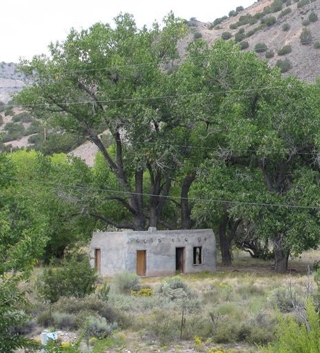
ideal location, and its remoteness led to the nickname “Lost Almost.” “Project Y” mail
handling was the furthest thing from anyone’s mind. Once the site was acquired and
construction started, however, the existing “Los Alamos” post office (a seasonal post
office that existed by that name for only two years) was shuttered on November 1,
1943. All future communications with the outside world (including birth certificates and
all other official documents) were handled officially through “PO Box 1663, Santa Fe,
NM.” As “Project Y” grew, five additional “drop boxes” were established by the end of
the war for specific, limited purposes, but everything remained “officially” PO Box
Postal History Journal No. 170 June 2018 Page 161663. Examples from only three others (Box 180, Box 1539 and, very recently, Box
527) have been reported. Covers to or from boxes 169 and 1036 have never been re-
ported. An additional box, Box 5370, Metropolitan Station (Los Angeles) was estab-
lished for journals and subscriptions, but examples from it, too, are still unknown.
Original Los Alamos
The original town of Los Alamos (1878 to 1914) was located about 200 miles
southeast of present-day Los Alamos, near the town of Roswell.
Figure 1: Postal card mailed from the original
Los Alamos, New Mexico, March 27, 1906.
Otowi
The Los Alamos Ranch School was established in 1917, atop the Pajarito Plateau
in northern New Mexico (northwest of Santa Fe), as an elite prep school for boys, under
the age of 18, from wealthy families. No seasonal post office was initially established
for the school, since the name “Los Alamos” was already taken, but mail was carried
daily to and from the nearby “Otowi”
post office. The Otowi post office (at
a railroad crossing at the base of the
plateau, next to the Rio Grande), was
opened November 9, 1920, to serve
(primarily) the ranch school and
homesteaders on the plateau. Otowi
changed its name to “Los
Alamos” (after the other Los Alamos
closed) on April 1, 1941, and served
for roughly two years as the seasonal
post office for the Los Alamos Ranch
School until being closed for the
Figure 3: The road to the Boy’s Ranch - narrow,
Manhattan project in 1943.
steep and winding, with numerous switchbacks.
Postal History Journal No. 170 June 2018 Page 17Figures 3 & 4: ca1940 postcard view of Otowi Bridge, next
to original post office site; Otowi as it appears today.
Figure 5: One of
only two known
covers with a
strike of the
Otowi postmark
(both appearing
on name-change
covers), and one
of only four
known strikes of
a prewar Los
Alamos postmark.
Government Takeover & PO Closing
By early 1943, preparations for the
Manhattan Project’s top-secret city
were well under way. The location
of the Los Alamos post office was
changed “in early 1943” to what
had been the Ranch School’s Trad-
ing Post (at the Project Y site) and
Figure 6: Letter sent from Los Alamos
March 21, 1943 by an employee of Low-
dermilk Construction, primary builders of
the road to the top-secret city.
Postal History Journal No. 170 June 2018 Page 18was closed November 1, 1943, with the establishment of the drop box system. Los
Alamos remained non-existent as a post office until well after the end of the war.
Figure 7: The second of
only two known examples
of a solo strike of Los
Alamos. The sender of
this March 16, 1943 air-
mail cover was with MM
Sundt Construction, pri-
mary builders of the top-
secret city. The Los Alam-
os post office was closed
months later.
Drop Box Mail
With the closing of the Los Alamos post office, all mail for scientists, workers and
families was officially designated “P.O. Box 1663, Santa Fe, N.M,” and all mail was
censored. No date is recorded for the opening of the drop box, other than “1943.” How-
ever, it is assumed the drop boxes commenced November 2, after the November 1 clos-
ing of the “Los Alamos” post office. Censorship of civilian mail on U.S. soil had never
been done before. Three round-trip mail runs were done every day by military drivers in
an open weapons carrier. Censor numbers known for Project Y include 2031, 2033,
2034, 2036, 2038, 2296, 2297, 2298 and 2299.
Figure 8: A censored commercial letter (Censor 2036) addressed to a Los Alamos employee -
December 29, 1943, one of the earliest possible uses of the drop-box system.
All mail was initially taken to the mail room established in the T Building (see map
next page). Base location for the mail facility changed twice more before the end of the
war. Outgoing mail was placed in the mailbox unsealed and was sealed by censors after
reading (again, with no markings to tip off recipients).
Postal History Journal No. 170 June 2018 Page 19Figure 9: Exam- ple from the most “common” drop box, Box 1663, an in- bound cover (Censor 2299) to a son from his mother (letter enclosed refers to his inability to disclose his location). Figure 10: P.O. Box 1539 was supposed to be used by local MED staff, and non-technical per- sonnel (including the Corps of Engineers). Inbound Sept. 18, 1944, Navy postmark from Sub- marine Repair Unit personnel from California FPO address (Censored by 2031). Postal History Journal No. 170 June 2018 Page 20
Figure 11: Three letters (censored, but not visibly so) from the same individual stationed with
 military technical staff. The top example (1944) is from Box 1663; the bottom example from
 1945 after a new Box 180 was established in May 1945.
     To repeat: although a total of six post office box numbers were eventually assigned
to the Manhattan Project at Los Alamos (all five additional were subservient to Box
1663), examples of mail are known from only four: P.O. Box 1663, P.O. Box180, P.O.
Box 1539 and Box 527 (a discovery of the author’s). Additional box numbers assigned
were 169 and 1036 but there are no known surviving pieces of mail from either.

                                                                                  Figure 12: An
                                                                                  outbound post-
                                                                                  card, August 19,
                                                                                  1945, from a
                                                                                  WAC using P.O.
                                                                                  Box 180, the box
                                                                                  established near
                                                                                  the beginning of
                                                                                  1945 for the use
                                                                                  of military tech-
                                                                                  nical staff and
                                                                                  WACs. There was
                                                                                  no need to censor
                                                                                  or mark an out-
                                                                                  bound postcard.

Postal History Journal No. 170                June 2018                                    Page 21
Figure 13: Two postcards addressed to P.O. Box 527, military police detachment (4817th SC, Eighth Service Command). The box was known to have been assigned but all examples of mail were assumed lost. Postal History Journal No. 170 June 2018 Page 22
Figure 14: Forwarded First Day Cover 8¢ Transport, addressed to a Los Alamos scientist.
 Reverse bears March 28 Berkeley postmark. There is, of course no Santa Fe receiving mark.
 Cover also is not censored (probably because of its philatelic nature). However, since it is mail
 addressed to a scientist it should not have been passed without question. One of very few in-
 bound covers known without censor markings.

 Figure 15: One of only two
 known telegrams addressed
 to Los Alamos Project Y
 (censored 2299), January
 1945.

                                                                   Figure 16: Only-known example
                                                                   of drop box V-Mail. Letter bears
                                                                   censor mark prior to filming, so
                                                                   double-censhorship at Y site was
                                                                   unnecessary.

Postal History Journal No. 170                June 2018                                    Page 23
Figure 17: Inbound regis- tered and cen- sored cover (Censor 2033) with Santa Fe receiving mark, Sep- tember 21, 1945. Figure 18: Example of an inbound, registered and censored cover from Mexico (Censor 2033, shown front and back), with postal markings, censor markings and 1945 receiving mark from Santa Fe. Cover features one of two-known “BASE POST OFFICE” markings, denoting Los Alamos base post office established immediately after the war to process departmental mail throughout Los Alamos (see map below right). Postal History Journal No. 170 June 2018 Page 24
Figure 19: April 1945 registered cover
                                                    from Philatelic Division in Washington,
                                                    D.C., with basic postage covered by per-
                                                    mit, 31¢ registry fee paid with stamps
                                                    (Censor 2299). Reverse (inset) has April 5
                                                    Santa Fe receiving mark and “March
                                                    5” (device misdate typo) “RECEIVED
                                                    Mail Room, Building A” from wartime
                                                    Manhattan Project location. Receiving
                                                    marks, very unusual during the heart of
                                                    the Project, began appearing more fre-
                                                    quently as the war wound down.

 Figure 20: Inbound and censored cover from Ireland, mailed August 4, 1945, just two days
 before the first atomic bomb was dropped (Censor 2296). Cover, perhaps held, bears additional
 August 23, 1945, forwarding marking from Washington, D.C.

Postal History Journal No. 170              June 2018                                  Page 25
Figure 21a & b: Censored incoming registered cover from Mexico (Censor 2033). Few foreign- originating covers are known in connection with the Manhattan Project. Additional item from Mexico (top right), a postcard. Because of the public nature of a postcard (with all contents visible), no censorship was necessary. Figure 22: Mili- tary “FREE” mail sent by service- man in California to friend stationed in Los Alamos. Cover has been censored (2034). As with any form of mail, mistakes happen even addressed to top-secret facilities. Examples of these connected with the Manhattan Project are extremely rare. Figure 23: Inbound censored mail (2036) from Mexico, was mis- sent to Silver City, New Mexico. Postal History Journal No. 170 June 2018 Page 26
Figure 24: One of very few auxiliary markings known for drop-box era Los Alamos. Letter
 inbound from Mexico March 2, 1945, and forward to relocated Los Alamos employee. Very few
 employees were allowed to leave before the end of the war. Because this individual was known
 in Los Alamos, it was apparently determined that censorship was not necessary.

                                      Postwar
     The drop box system (and most of the security measures regarding mail) continued
until early 1947. Secrecy did not end with the dropping of atomic bombs in August
1945.

 Figure 25: December 19, 1945, cover from APO address to individual at Camp Pickett, Vir-
 ginia, forwarded to Santa Fe hospital, where it was mistakenly mixed with Manhattan Project
 mail. Only known auxiliary marking from Box 1539. Cover is non-censored as censorship was
 dropped December 3, 1945.

Postal History Journal No. 170              June 2018                                  Page 27
Figure 26: Postwar letter (1947) forwarded from P.O. Box 1663 Santa Fe, to an address in
California. There was no immediate postwar provision for re-establish a post office in the still
top-secret city.
On August 1, 1946, President Harry S Truman signed the Atomic Energy Commis-
sion Act into effect. While Los Alamos remained a city under strict national security, it
was allowed to become a more normally functioning one, including the re-establish-
ment of the Los Alamos post office (by name and postmark), accomplished in May
1947. The new official address of the “Lab” became P.O. Box 1663, Los Alamos, New
Mexico (rather than Santa Fe).
Figure 27: Postwar
letter addressed to
P.O. Box 1663, San-
ta Fe, forwarded
from P.O. Box 1663,
Los Alamos, after
the 1946 Atomic
Energy Commission
Act allowed for the
re-establishment of
a Los Alamos post
office.
Postal History Journal No. 170 June 2018 Page 28Figure 28: 1946 publication regarding the development
of the bomb “by Los Alamos Scientists.” Publication
mailing rate allowed this piece to be opened for inspec-
tion if necessary. Mailing address was still P.O. Box
1663, Santa Fe.
Figure 29: Example of an early hand-stamped postmark from the Atomic City of Los Alamos.
While it is not known on exactly what date “Los Alamos” postmarks were once again institut-
ed, control of the post office was given over to the U.S. Post Office Department by the War
Department on May 9, 1947. This cover was postmarked just a week later, on May 16, 1947.
Postal History Journal No. 170 June 2018 Page 29Figure 30: An early
example of a ma-
chine cancel from
Los Alamos. Note
sender’s address:
General Delivery.
The establishment of
post office boxes and
residential delivery
took several years to
complete.
Even though the address of the Los Alamos Scientific Laboratory eventually
changed several times, examples of P.O. Box 1663 persisted well into the 1970s. The
mail, of course, was delivered.
Figure 31: In-
bound 1952 letter
from Germany
sent to Los Alam-
os, but missent to
St. Louis. Despite
the use of the
generic Box 1663
address the mail
(once directed to
the proper city)
was delivered.
Wayne Youngblood began his professional involvement with philately when he joined
the staff of Linn’s in 1987. He has been editor of Scott Stamp Monthly, editor-publisher
of Stamp Collector, vice president at Regency-Superior Auctions, and is now editor of
The American Stamp Dealer & Collector, and The Collector’s Club Philatelist. Wayne
is the longest-serving instructor for the American Philatelic Society Summer Seminar,
teaching a class on stamp technology for more than a quarter century. He also is a past
APS director and serves as an expertiser for the American Philatelic Expertizing Ser-
vice. He was inducted into the APS Writers Unit and the Wisconsin Federation of
Stamp Club’s Halls of fame and is current president of the Errors, freaks and Oddities
Collectors Club. He is the author of a dozen books and thousands of columns and fea-
tures - his contribution to the hobby is immeasurable; his enthusiasm infectious.
Postal History Journal No. 170 June 2018 Page 30A Remington in Paris
By Peter Martin
The first practical commercial typewriter is credited to Christopher Latham
Scholes, a Milwaukee, Wisconsin inventor, who patented his idea in 1874. The formal
introduction for the “type-writer” was at the Centennial Exhibition in Philadelphia in
1876. There, the typewriter was on display and visitors could get a souvenir typed at the
exhibition for 25 cents. Figure 1 shows an example.
Figure 1: Typed
letter and enclosure
from the 1876 Cen-
tennial International
Exhibition in Phil-
adelphia, mailed
from the fair post
office September 18.
Postal History Journal No. 170 June 2018 Page 31Typewriters remained a popular attraction at international fairs and expositions
well into the early 20th century. While there is considerable typewriter advertising
material from the pioneer days of the typewriter, material documenting typewriter
manufacturer participation at international fairs and expositions is rare. That is
especially true of foreign events. So I was delighted to recently find the Figure 2
Remington postcard from the Paris Exposition of 1900.
Figure 2: The message side of the postcard in Figure 3, written at the Paris fair July 2, 1900,
and mailed to Barcelona.
The message side of the postcard (Figure 2) features a young woman pecking away
on a Remington typewriter under the French text that translates to: Souvenir of the
Remington Typewriter, Paris Exposition 1900. Courtesy of the American Philatelic
Society Translation Committee, here is the postcard text:
Paris, 2 July 1900
My Dear Friend D’amaso:
We are doing well and I believe we will return by the middle of next week. I am surprised I
have not heard any news from you.
If you go to the “Buena Sombra” (Good Shadow), tell Emelia and Maria I said hello, and
Carmen also.
Do not forget to say hello to all our other friends. I remain sincerely yours,
Najo’
An additional note from translator Larry DiFiore provided some interesting
background information. A search of the Internet revealed that a famous café by the
name of the Buena Sombra (Good Shadow) was the center of nightlife in Barcelona,
Spain, under various names from 1884 up to 1988. Located at Number 3 Ginjol Street
Postal History Journal No. 170 June 2018 Page 32in downtown Barcelona, the café was preceded by the Café Sevillano, the French
Alcázar and the Crystal Palace beginning in 1884, at the same location.
The café under its last name, The Buena Sombra, was featured in a Spanish novel
published in 1919. In the late 1800s and early 1900s it was fashionable for nightlife in
the major cities of Spain to imitate the fabled nightlife in Paris. Instead of cabaret-style
French music, the cafés such as La Buena Sombra featured zarzuelas, flamencos, and
other musical styles typical of Spain.
It is interesting to speculate that perhaps Najo and D’amaso frequented the café in
Barcelona along with the friends mentioned in the postcard.
The address side of the postcard (Figure 3) confirms that the addressee, Damaso
Domingues, resided at Plaza Real 3-1 in Barcelona. The French 10 centimes stamp is
cancelled with a double-circle “Paris Exposition Presse” cancel dated July 2, 1900.
he never replied to my two registered letters requesting evidence supporting his statement of
frequency as 6 only (unique:12).
29
Vlastos , op.cit. no. 5, Zaphiriou, pp. 116-117.
30
Umberto del Bianco, Il Lloyd Austriaco e gli annuli marittimi dell’ Austria–Ungheria, vοl 3,
Attivita Postale autonoma Lloydiana nei porti Italiani, nelle Isole Jonie e in Grecia, Sorani
Milano 1982, p. 488.
31
Zaphiriou, pp. 196-198 and 212. No reference is made as to his source for the date of dispatch
from England.
32
O.D. Cumming, “The Postal Rates in Ionian Islands”, Philotelia 1998, pp. 203-210.
33
O. D. Cumming, “Mysterious Corfu Marks, 1847-1851”, Postal History Journal no.
293/2000, pp. 9-13.
34
Zaphiriou: p. 151 for tariff.
35
Zaphiriou: p.149.
36
A.Buchon: Voyage dans l’ Eubée, les Iles Ioniennes et les Cyclades en 1841, Paris 1911 p.79.
37
Zaphiriou, p. 158.
38
Paul Johnson, The Birth of the Modern World Society 1815-1830, Phoenix, London 1992,
pp.166-169.
Figure 3: Address side of the postcard in Figure 2, to D’amaso Domingues in Barcelona.
Gerasimos M. Vlachos, an internationally known scholar of the Ionian Islands, presented
a different version of this paper to the Academie Europienne de Philatelie in 2013 (Opus
Peter Martin is publisher of La Posta Publications, who most recently edited Aspects
XIII). Our thanks to Terry Hines for aiding with the English translation. In PHJ 126
of American Postal History, reviewed in PHJ 168. Peter was the former editor of sever-
October 2003, D. P. Zaphiriou commented on the famous “Rothschild Cover” from the
al Ionian
philatelic journals,
Islands, with aasfollow-up
well as past president
history of theof
and analysis APS Writers
the piece by Unit.
Herbert A. Trenchard
in PHJ 128 June 2004.
Support our Journal advertisers!
& consider running a small ad: single insertion 2.5 x 2” just $20.
promote an author; honor a collector; support the hobby.
Full page advertisement, 3 insertions $400. Half page, 3 insertions $250.
Postal HistoryPostal
Journal History
No. 170 June 2018 & Board of Directors
Society Officers Page 33
Pres.: Yamil Kouri, 405 Waltham St., #347, Lexington MA 02421.
Vice Pres. & Awards Chair: Douglas N. Clark, P.O. Box 427, Marstons Mills MA 02648.
Sec./Treas.: Gary Loew, P.O. Box 468101, Atlanta GA 31146
Publicity Chair: David M. Frye, phs-publicity@widesky.biz
Class of 2018 Kenneth Grant kenneth.grant@uwc.edu
Yamil Kouri yhkouri@massmed.org
Timothy O’Connor timoconnor1@comcast.net
Class of 2019 Douglas N. Clark dnc@math.uga.edu
Fernando Iglesias fciglesias@earthlink.net
Sandeep Jaiswal sj722@aol.com
Class of 2020 Terence Hines Terencehines@aol.comYou can also read