Gold18@Perth - SJS Resource Management
←
→
Page content transcription
If your browser does not render page correctly, please read the page content below
Gold18@Perth

                  EXTENDED ABSTRACTS
              An Australian Institute of Geoscientists
            symposium organised in conjunction with
                     Geoscientists Symposia

 Sponsors
            2nd and 3rd August 2018
                Perth, Western Australia

                     Edited and compiled by
                       Julian Vearncombe
                      Bulletin No. 68 - 2018
Gold18@Perth
– Extended Abstracts

© Australian Institute of Geoscientists
This booklet is copyright. All rights reserved. No part of this publication may be reproduced or stored in a retrieval system
or transmitted in any form or by any means electronic, mechanical, photocopying, recording or otherwise without the prior
permission in writing of the copyright owners.

Bulletin number 68
ISBN-13: 978-0-9750047-8-4

ISSN: 0812 60 89

DISCLAIMER
The Organising Committee sought to obtain a broad coverage of this topic. Every effort was made to minimise amendments
in content of the resultant abstracts. Abstracts including references have been reproduced as submitted with changes restricted
to typographic, punctuation and layout only. The opinions and statements within the individual papers comprising the Bulletin
reflect solely the viewpoint of their authors, and are not necessarily shared by the Organising Committee or the Australian
Institute of Geoscientists.
Short quotations from the text of this publication and copies of maps, figures, tables etc (excluding any subject to pre-existing
copyright) may be used in scientific articles, exploration reports and similar works provided that the source is acknowledged
and subject to the proviso that any excerpt used, especially in a company prospectus, Stock Exchange report or similar must be
strictly fair and balanced. Other than for the purposes of research or study the whole work must not be reproduced without the
permission in writing of the Australian Institute of Geoscientists.

ORGANiSING COMMITTEE
•   Julian Vearncombe (SJS Resource Management)

•   Loraleen Gonzales (geosymposia.com.au)

•   Joe Dwyer (HiSeis)

Typesetting
Julie Kelly, e-type design            julie@etypedesign.net.au

                                              Gold18 – August 2018 – Perth, Western Australia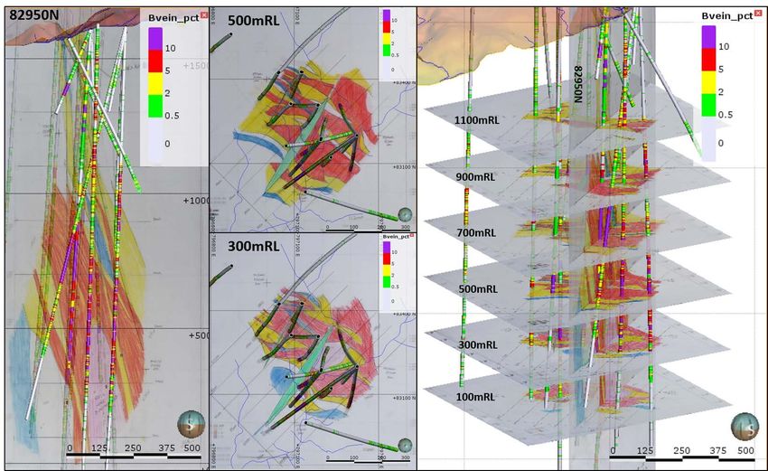
Gold18@Perth

Thank you to our sponsors:

  Gold18 – August 2018 – Perth, Western Australia
Contents

Author                                          title                                                                        Page

                                                Gold dispersion in transported cover sequences linked to landscape
R. Anand, W. Salama                                                                                                           1
                                                history of the Yilgarn Craton

C. R. M. Butt, R. M. Hough, M. Verrall          Gold nuggets: the inside story                                                5

                                                Artificial Unintelligence—why a simplistic focus on ‘big data’ processing
E. J. Cowan                                                                                                                   9
                                                will not result in mineral exploration success and what we can do about it

D. Craw                                         Origin of gold nuggets in Regolith, Otago Schist, New Zealand                 12

M. Dentith                                      Geophysical exploration for orogenic gold mineral systems                     16

D. Falconer                                     Novo Gold: a closer look                                                      20

                                                The importance of geological mapping, core-logging and
S. Garwin                                       3D geoscientific data integration in the exploration of porphyry              21
                                                copper-(gold) deposits
                                                Importance of repetitive structural geometry in orogenic gold
D. I. Groves                                                                                                                  26
                                                exploration

E. A. Hancock                                   Applying gold fingerprinting to mineral prospectivity studies                 28

Q. Hennigh                                      Conglomerate-hosted gold in the Pilbara, Western Australia                    31

                                                Nonlinear analysis, kriging, predictions and forecasting in mineral
B. E. Hobbs, A. Ord                                                                                                           34
                                                systems

M. Lintern, S. Bolster, P. Williams             Field analysis of gold using new detectORE™ technology                        39

                                                Application of mineral mapping technology: a new component of an
J. Miller, A. Bath, J. Walshe, R. Birchall      explorers tool kit for the integrated mapping and detection of a gold         41
                                                system footprint under cover
R. J. Morrison                                  Target gold N.E. Queensland                                                   43

G. N. Phillips                                  Conglomerate-hosted gold deposits: what is so special?                        45
                                                Archaean palaeoplacer Au deposits of the Pilbara Craton and Fortescue
F. Pirajno, L. Bagas, A. Hickman                                                                                              48
                                                Basin compared to palaeoplacer Au deposits in the Witwatersrand Basin
                                                Ferruginous pisoliths as a powerful regolith sampling medium for
W. Salama, R. Anand                                                                                                           53
                                                exploring areas covered by sand dunes
R. G. Smith                                     The business of exploration in the 21st century                               55

C. Tremblay                                     PhotonAssay: bringing gold to the light                                       57
                                                A proposed revision of the orogenic gold class, based on multiple ore
W. K. Witt, S. G. Hagemann, K. F. Cassidy                                                                                     60
                                                fluid compositions inferred from proximal alteration
J. Youngson                                     Conglomerate-hosted gold deposits in an evolving basin                        65

                                             Gold18 – August 2018 – Perth, Western Australia
1   l   Gold dispersion in transported cover sequences linked to landscape history                                                       R. Anand, W. Salama
        of the Yilgarn Craton

Gold dispersion in transported cover sequences linked
to landscape history of the Yilgarn Craton
                                                                                                                                       R. Anand1, W.Salama2

Introduction                                                                        grains and gossan fragments and (ii) hydromorphic
                                                                                    dispersion after deposition of the cover by groundwater
This paper examines how geochemical dispersion may be                               percolating through the coarse, basal sediments, along the
used in areas of deep transported cover to locate buried                            unconformity itself and/or the upper residual material
mineralisation. Transported cover generally refers to exotic                        (Anand et al., 1993; Robertson et al., 1996; Anand,
or redistributed material of continental origin that blankets                       2000; Robertson et al., 2001; Butt et al., 2005; Anand
weathered and fresh bedrock. Extensive transported cover                            and Robertson, 2012). These mechanisms result in lateral
obscures many prospective areas in Australia and this                               dispersions at the base of cover without upward dispersion
presents a critical challenge to mineral exploration. Surficial                     into soil.
techniques have limited application in areas of deep cover.                         Chemical interface (palaeoredox fronts) sampling is based on
The cost of deep drilling renders high-density sampling                             hydromorphic dispersion into weathering products such
of the weathered basement beneath the unconformity                                  as Fe and Mn oxides formed in sediments.  Iron oxides
economically ineffective.  However, the cover itself may                            are concentrated in ferruginous nodules, pisoliths and
provide an opportunity for exploration and we present                               mottles. In places, depending upon the landscape history, a
some results to highlight this from gold deposits covered                           geochemical signature of mineralisation may be present in
by Permian, Eocene-Miocene and Quaternary sediments                                 them (even up to ore grade for Au).
in the Yilgarn Craton. These sediments include glacial,
fluvioglacial, colluvial-alluvial, lacustrine, estuarine, marine
and aeolian material, and several may occur at any given
                                                                                    Transported cover environments and gold
site (Anand and Paine, 2002). These sediments overlie fresh
or weathered Archaean bedrocks. For cover to be a useful
                                                                                    dispersion
sample medium it depends on indicator elements being                                Permian sediments
dispersed into these sediments during deposition and/or
post-depositional weathering and diagenesis. The relative                           Overlying Archaean crystalline basement in the eastern
timing of continental sedimentation and the principal                               Yilgarn Craton are scattered remnants of Gondwanan
weathering events are important to exploration. Older                               Permo-Carboniferous fluvio-glacial sediments. These
sediments are more likely to contain chemical dispersions                           comprise boulder-rich diamictite, sandstone, siltstone and
from concealed mineralisation. Those deposited before,                              claystone filling broad and shallow valleys. The sediments
during or just after the main phases of deep weathering in                          in the shallow valleys are commonly derived from proximal
the late Cretaceous and Eocene-Miocene will have been                               erosion of bedrock whereas, in broad valleys, they are more
subjected to more post-depositional alteration (and therefore                       distal. Permian sediments are commonly poorly indurated,
trace element dispersion) than younger sediments such as                            strongly weathered and ferruginised (mottling, nodules,
recent colluvium and alluvium (Anand et al, 1993; Butt et                           pisoliths) and difficult to distinguish from later sediments.
al., 2005; Anand and Robertson, 2012; Anand, 2016).  It                             Some of the deeper glacial deposits are unweathered.
is impractical to sample the whole sedimentary sequence;                            Examples of dispersion from Au deposits into Permian
therefore selective sampling is required. There are two types                       sediments in the Yilgarn Craton are from Agnew (Carver
of interface that may be used to discover mineralisation.                           et al., 2005; Salama et al., 2016; Salama and Anand,
These include physical and chemical interfaces which are                            2017), Lancefield South (Anand and Robertson, 2012),
generic, abundant and easy to sample.                                               Tropicana (Lintern et al., 2009), Smokebush and Toppin
Physical interface sampling is based on the possibility of                          Hill (Salama and Anand, 2018a, this volume). The Agnew
dispersion at or close to an unconformity by (i) mechanical                         and Lancefield Au deposits are examples of mechanical
dispersion of remnants of ferruginous duricrust, mineral                            dispersion of mineralized detritus into Permian sediments.

1. CSIRO, Mineral Resources, 26 Dick Perry Avenue, Kensington WA 6151, Western Australia      Corresponding author: Ravi Anand      Email: ravi.anand@csiro.au
2. CSIRO Mineral Resources, Perth, Western Australia

                                                        Gold18 – August 2018 – Perth, Western Australia
2   l   Gold dispersion in transported cover sequences linked to landscape history                                       R. Anand, W. Salama
        of the Yilgarn Craton

At Lancefield, a 25 m thick deeply-weathered ferruginised                     the palaeovalleys and palaeochannels. In palaeovalleys,
Permian fluvial sequence is exposed unconformably                             colluvial-alluvial detritus, derived from continuous upslope
overlying weathered Archaean ultramafic rocks. The basal                      erosion, accumulate on footslopes and valley floors within
Permian unit is a coarse, matrix-supported conglomerate,                      a toposequence. In contrast, sediments related to more
consisting of a variety of rounded and angular metavolcanic,                  specific environmental changes are alluvial, lacustrine or
granitic and BIF cobbles and boulders, set in a gritty                        estuarine-marine sequences that have been deposited in
matrix of similar composition, interbedded with gritty,                       palaeochannels. In palaeovalleys, the detritus was sourced
cross-bedded sandstones (Anand and Robertson, 2012).                          from nodules and pisoliths from older duricrust and lithic
The whole Permian sedimentary column is enriched in                           fragments of less weathered materials such as saprock and
Au (to 120 ppb), As (to 550 ppm) and Cu (to 150 ppm).                         saprolite. Iron oxide cementation of detritus in palaeovalleys
Post-depositional ferruginisation (chemical interface) has                    formed ferricrete (chemical interface). Overprinting of
redistributed these metals, leading to enrichment in goethite                 ferricretes has occurred in palaeovalleys as the sediments
and hematite in the mottled horizon. Thus, hematite and                       were subsequently reweathered by groundwater in the
goethite are the main carriers of As (mean 1260 ppm) and                      presence of organic matter. Goethite and kaolinite were
Cu (mean 295 ppm). Anomalies in ferruginised Permian                          precipitated to form yellow cortices and authigenic pisoliths,
sediments are formed by mechanical dispersion followed by                     and voids and cracks were filled. Evidence for the interaction
post-depositional hydromorphic dispersion in later formed                     of vegetation and microbes with ferricrete is preserved in
Fe oxides of mottles. Although anomalies in the overlying                     root channels, organic C and microbial fossils, confirming
Eocene-Miocene and Quaternary cover have been weakened                        significant biological modification.
by post-depositional processes over a long time, they still                   In these palaeovalley environments, because of lateral
remain (Anand and Robertson, 2012).                                           dispersion, geochemical anomalies are large, measuring
The Tropicana (Albany Fraser region; Lintern et al., 2009),                   hundreds of metres to several kilometres in length for Au
Smokebush and Toppin Hill gold deposits (Yamarna                              and pathfinder elements in pisoliths and nodules (e.g.,
belt; Salama and Anand, 2018a, this volume) represent                         Moolart Well, Mt Gibson, Bull China, Empire, Gourdis
an environment where extensive sheets of ferruginous                          gold deposits). However, ferricrete can contain ore-grade Au
pisoliths and nodules (ferricrete) are developed at the top                   with or without any known significant underlying primary
of Permian sediments. Permian sandstone and siltstone                         mineralisation. Gold, characteristically, shows an increase
are overlain by recent aeolian sand. The authigenic nodules                   in grade and purity in ferricrete compared to the underlying
and pisoliths of the Fe-cemented sediments have a mixed                       saprolite. Gold enrichment in nodules and pisoliths is mostly
origin, ranging from Permian sandstone, to aeolian sand.                      secondary (Ag-poor) nanometre- to micron-sized spheres,
Ferruginous nodules and pisoliths show an expression of                       irregular, chains, hexagons, triangles and wires in precipitates
buried mineralisation at all these sites. At these locations,                 of organic C, goethite, kaolinite and amorphous Si within
Au concentrations reach tens to hundreds of ppb or more                       cortices, cracks and cavities in pisoliths. Spectacular
against a background of
3   l   Gold dispersion in transported cover sequences linked to landscape history                                         R. Anand, W. Salama
        of the Yilgarn Craton

overlain by a clay-rich paludal unit of probable Oligo-                       is considered to have been derived from erosion of saprolite
Miocene age (Perkolilli Shale). These sediments are derived                   and saprock. The upper parts of these sediments have been
from the erosion of a pre-existing weathered profile. The                     variably silicified and calcified, possibly enhanced by short
palaeochannel sediments are commonly overprinted by                           periods of water saturation.
ferruginisation and in places by silicification. Ferruginisation is           Dispersion of Au and associated elements in basal gravelly
widespread as megamottles or nodules, pisoliths or massively                  colluvium at Mt Gibson (Anand et al., 1989), Mt McClure
cemented zones at upper levels; mostly, but not exclusively,                  (Anand et al., 1993; Anand and Williamson, 2000),
above the modern level of the water table (Anand and Paine,                   Lawlers (Anand et al., 1993) and Bronzewing (Anand et
2002). Two ferruginous materials formed in palaeochannel                      al., 2001; Anand, 2015) indicated that sampling close to the
sediments are most relevant to exploration. These are                         unconformity could be a useful procedure, where the deepest
(i) ferruginous basal sand and gravel at the base of the                      transported units are composed of lateritic gravel. Where
palaeochannel (physical interface) and (ii) goethite pisoliths                the shallow cover (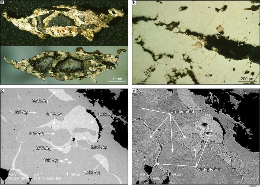
4   l     Gold dispersion in transported cover sequences linked to landscape history                                                 R. Anand, W. Salama
          of the Yilgarn Craton

References                                                                       Butt, C.R.M, Scott, K.M., Cornelius, M. and Robertson, I.D.M., 2005.
                                                                                    Sample Media. In: C.R.M. Butt, M. Cornelius, K.M. Scott and I.D.M.
                                                                                    Robertson (Eds), Regolith Expression of Ore Systems, CRCLEME,
Anand, R.R., Smith, R.E., Innes, J. and Churchward, H.M. 1989.
                                                                                    2005, 1-27 pp.
  Exploration geochemistry about the Mt Gibson Gold Deposits,
  Western Australia. CSIRO Division of Exploration Geoscience, Perth,            Carver, R., Baker, P. and Oates, C. Redeemer gold deposit, Agnew district,
  Restricted Report Number 20R, 96 pp. (Reissued as Open File Report                WA. In: C.R.M. Butt, I.D.M. Robertson, K.M. Scott and M. Cornelius
  35, CRC LEME, Perth, 1998).                                                       (Eds), Regolith Expression of Ore Systems, CRCLEME, 2005, 1-3 pp.
Anand, R.R., Smith, R.E., Phang, C., Wildman, J.E., Robertson, I.D.M.            de Broekert, P., Sandiford, M., 2005. Buried inset-valleys in the Eastern
  and Munday, T.J. 1993. Geochemical exploration in complex lateritic               Yilgarn Craton, Western Australia: geomorphology, age and allogenic
  environments of the Yilgarn Craton, Western Australia. CSIRO                      control. Journal of Geology. 113, 471-493.
  Division of Exploration Geoscience, Perth, Restricted Report                   Lintern, M., Anand, R.R., Hough, R., Shaw, D. and Pinchand, T., 2009.
  Number, Volumes 1, 2 & 3, 569 pp. (Reissued as Open File Report 58,               Biogeochemical and regolith investigations at Tropicana gold deposit,
  CRCLEME, Perth, 1998).                                                            Western Australia. CSIRO Report P2009, 74pp.
Anand, R.R., 2000.  Regolith and geochemical synthesis of the Yandal             Lintern, M., Anand, R. and Reid, N. 2013. Exploration geochemistry at
  greenstone belt.  In: Neil Phillips and Ravi Anand (Editors), Yandal              Garden Well Gold Deposit NE Yilgarn Craton (Western Australia).
  Greenstone Belt, Australian Institute Bulletin 32, 79-111.                        Report No EP1310007, 115pp.
Anand, R.R. and Williamson, A., 2000.  Regolith evolution and                    Robertson, I.D.M., Phang, C. and Munday, T.J. 1996. The regolith geology
  geochemical dispersion in residual and transported regolith-Calista              and geochemistry of the area around the Harmony Gold Deposit,
  deposit, Mt McClure district.  In: N. Phillips and R. Anand (Eds),               (Baxter Mining Centre), Peak Hill, Western Australia. CSIRO
  Yandal Greenstone Belt, Australian Institute Bulletin 32, 333-349.               Exploration and Mining Restricted Report 194R. 149 pp. (Reissued as
Anand, R.R., Wildman, J.E., Varga, Z.S. and Phang, C., 2001.  Regolith             Open File Report 94, CRC LEME, Perth, 2001).
  evolution and geochemical dispersion in transported and residual               Robertson, I.D.M., King, J.D. and Anand, R.R., 2001.  Regolith geology
  regolith-Bronzewing gold deposit.  Geochemistry: Exploration,                    and geochemical exploration around the Stellar and Quasar gold
  Environment, Analysis 1: 265-276.                                                deposits, Mt Magnet, Western Australia.  Geochemistry: Exploration,
Anand, R.R. and Paine, M., 2002. Regolith geology of the Yilgarn Craton,           Environment, Analysis 1: 353-365.
  Western Australia: implications for exploration. Australian Journal of         Salama, W., Anand, R.R., Verrall, M., 2016. Mineral exploration and
  Earth Sciences, 49: 3-162.                                                        basement mapping in areas of deep transported cover using indicator
Anand, R.R. and Robertson, I.D.M., 2012.  Role of mineralogy and                    heavy minerals and paleoredox fronts, Yilgarn Craton, Western
  geochemistry in forming anomalies on interfaces and in areas of deep              Australia. Ore Geology Reviews 72, 485-509.
  basin cover-implications for exploration. Geochemistry, Exploration,           Salama, W. and Anand, R.R., 2017. Reconstructing the pre Quaternary
  Environment and Analysis 12:45-66.                                                landscape in Agnew-Lawlers area, Western Australia with emphasis
Anand, R.R., 2015. The importance of 3D regolith-landform control in                on the Permo Carboniferous glaciation and post glacial weathering.
  areas of transported cover implications to exploration. Geochemistry:             International Journal of Earth Sciences 106, 311–339.
  Exploration, Environment, Analysis 16, 14-26.                                  Salama, W. and Anand, R.R., 2018a. Ferruginous pisoliths as a powerful
Anand, R.R., 2016. Regolith-landform processes and geochemical                      regolith sampling medium for exploring areas covered by sand dunes.
  exploration for base metal deposits in regolith-dominated terrains of the         AIG abstract volume.
  Mt Isa region, northwest Queensland, Australia. Ore Geology Reviews            Salama, W. and Anand, R., 2018b. Regolith-landform evolution and
  73, 451-474.                                                                      geochemical exploration through transported cover at Yamarna Terrane,
Anand, R.R., Lintern, M., Hough, R., Noble, R., Verrall, V., Salama, W.,            Western Australia. CSIRO Mineral Resources report, Perth, Australia,
  and Balkau, J., 2017. The dynamics    of gold in regolith change with             159p.
  differing environmental conditions over time. Geology, 45, 127-130

        Biography
        Ravi Anand is a Chief Research Scientist at CSIRO and an Adjunct Professor in regolith geology and geochemistry
        at Curtin University of Technology, Perth, Western Australia. He has over 30 years research experience in regolith
        geoscience and exploration geochemistry, mainly in developing procedures for gold, base metals, heavy minerals and
        bauxites exploration in deeply weathered terrains. His current research in collaboration with the industry is focussed on
        understanding metal dispersion processes through transported cover and has led several multi-clients CSIRO-AMIRA
        projects on this topic.  He has received many national and international awards for regolith research in collaboration with
        the mining industry, including a Gold Medal from the Association of Applied Geochemists.

                                                       Gold18 – August 2018 – Perth, Western Australia
5   l   Gold nuggets: the inside story                                                                                  C. R. M. Butt, R. M. Hough, M. Verrall

Gold nuggets: the inside story
                                                                                                                   C. R. M. Butt1, R. M. Hough1, M. Verrall1

Introduction
The origin of gold nuggets, here defined as separate masses
>1 g or >4 mm, has long been debated by geologists. They
have been subject to few scientific studies, and theories
of their formation have been based more on speculation
than fact.  Many prospectors and geologists have long
considered most nuggets to be secondary, formed in
residual and alluvial surficial environments. The relative
abundance of nuggets in these settings, contrasted
with their rarity in gold lodes, appeared to support this
conclusion. Nonetheless, it was conceded that some
nuggets contain vein quartz and some, mostly smaller,
specimens had been found in lodes. The mechanisms
proposed include accretionary chemical growth (Wilson,
1984), by purely inorganic reactions or possibly bacterially                         Figure 1. Coolgardie 1, Liversidge Collection. Optical image, oblique
mediated mechanisms (Southam et al., 2009), through to                               reflected light. Polycrystalline fabric, crystals up to 1 cm, many twinned,
physical agglomeration of grains in high energy fluvial                              with rectilinear voids along many crystal boundaries. As found, the
environments (Burban, 2004).   However, in the 1890s,                                nugget had a mass of 9.94 oz troy (309 g). (Photo: CRM Butt 2007;
Liversidge concluded on geological grounds that nuggets                              similar to that in Liversidge 1897).
in weathered rock, soil and alluvium are of primary
(hypogene) origin, even though he had demonstrated
the probable chemical mobility of gold in groundwater.
                                                                                     Petrography
Polished gold is generally highly reflective and featureless                         Most nuggets and large grains are polycrystalline, with
due to mechanical deformation of the surface (Beilby                                 the crystals seemingly randomly orientated, of broadly
layer). Borrowing techniques from his previous studies                               similar sizes within individual nuggets and grains, and of
of meteorites, Liversidge etched his polished specimens,                             approximately equant dimensions.  Many of the crystals
dissolving the Beilby layer and corroding the exposed                                are twinned, either as simple contact twins or as multiple
substrate to reveal their crystalline structure. Individual                          (polysynthetic) twins, clearly visible both optically (Figure
crystals and twins etch differently due to variations in                             2) and by SEM.  The polycrystalline fabric is interpreted as
orientation, resulting in the distinctive fabrics he observed                        being due to thermal annealing at temperatures >~250 C
(Figure 1). Unfortunately, Liversidge’s conclusions                                  (Hough et al., 2007).  Nuggets from two sites in Papua-New
and, in particular, his petrographic observations and                                Guinea exhibit quite different fabrics; from one site, nuggets
techniques, were forgotten.  Nearly a century later, Wilson                          have concentric layering and from the other frond-like
(1984) did not etch his specimens and hence saw only                                 crystals surrounding a central core. These are interpreted as
featureless polished surfaces, misinterpreting the nuggets                           being primary, epithermal fabrics.
as supergene.  He could not see the crystal structures and                           Excluding the fine-grained secondary particles, crystal sizes
other physical characteristics of the nuggets which give                             vary from a few tens of micrometres to over 1cm. Obviously,
insights into their thermal and tectonic history and the                             larger crystals tend to occur in large nuggets, but this not
effects of exposure to weathering.                                                   always the case; a ‘nugget’ in vein quartz from the Central

1. CSIRO Mineral Resources, Box 1130, Bentley, Western Australia 6102     Corresponding author: C.R.M. Butt     Email: charles.butt@csiro.au

                                                         Gold18 – August 2018 – Perth, Western Australia
6   l   Gold nuggets: the inside story                                                                                 C. R. M. Butt, R. M. Hough, M. Verrall

                                                                                    Composition
                                                                                    SEM-EDX analyses of the nuggets and grains has shown
                                                                                    that, apart from Ag, there is no other metal alloyed with
                                                                                    Au, using a conservative detection limit of 1 wt%, with the
                                                                                    exception of Hg in one sample.  Silver concentrations range
                                                                                    from
7 l Gold nuggets: the inside story C. R. M. Butt, R. M. Hough, M. Verrall
uncleaned, Jundee MRC04 appeared massive externally
(Figure. 2) but, in section, it consists of an irregular,
broadly lathe-like, open network of polycrystalline gold,
separated by cavities filled with Fe oxide and ferruginous
clay. The cavities were probably formed by the dissolution
of primary minerals (e.g., carbonates) during weathering.
The majority of nuggets similarly have internal voids.
Larger internal voids commonly occur at the triple points
of intersecting linear voids that have formed along crystal
boundaries (Figure 4). Consequently, voids are generally
interconnected, at least in 3D space and, in all cases, the
void network is open to the exterior. In consequence, they
are commonly filled by fine, usually ferruginous, clay derived
from the regolith in which the nugget occurs. Even the
largest nuggets (to 8 kg) may have voids extending deep
into the interiors. The void fill itself commonly hosts very
fine particles of secondary gold, including fine dendritic Figure 4. Nugget Yilgarn PM3. A: cleaned, pitted external surface with
structures, indicating weathering and gold mobility, was numerous pores. B: polished section, not etched, showing that the gold
(khaki) forming the nugget is penetrated by numerous interconnected
ongoing after the fill was emplaced.
equant and rectilinear voids containing fine clay and Fe oxides (brown).
Silver-poor rims, generally 10-100 µm thick, have commonly Optical image, oblique reflected light. C: SEM image of etched polished
been reported on gold grains recovered from alluvial deposits surface. Gold: smooth, medium grey, with varying tones indicating
and residual regolith profiles. Similar depletion rims are different crystals. Clay and Fe oxides: high relief, pale grey to white, in
present on some nuggets, but are also extensively developed irregular equant voids and extending along grain boundaries forming
a 3-dimensional network. D: SEM-BSE image of two irregular voids
internally. This is most clearly seen by SEM (BSE) on
and connecting rectilinear voids in primary gold (pale grey). The void
unetched samples, as internal veinlets and patches (Figure 5), filling consists of Fe oxides and ferruginous clays (dark grey), with open
but the distribution is clarified by viewing etched surfaces, void space (black) and numerous fine particles of secondary gold (pale
on which it is apparent that the ‘veinlets’ follow crystal grey-white). Primary gold contains 6-7wt% Ag, secondary gold 0wt%
boundaries and the ‘patches’ are individual crystals that Ag. Perth Mint.
Figure 5. Queensland 1337 fragment. (a) Etched surface: top, by Liversidge; bottom, after re-polishing. (b) Part of section before etching, showing Ag
depletion (darker yellow). (c) SEM BSE image of polished surface before etching, showing areas and veinlets of Ag depletion; electron microprobe analyses.
(d) SEM BSE image after etching; individual crystals have different etching patterns, with Ag depletion along crystal boundaries and affecting specific
crystals. Liversidge Collection (from Butt & Timms, 2011).
Gold18 – August 2018 – Perth, Western Australia8 l Gold nuggets: the inside story C. R. M. Butt, R. M. Hough, M. Verrall are partially or wholly depleted in silver throughout. The depletion boundary is usually sharp (
9   l   Artificial Unintelligence—why a simplistic focus on ‘big data’ processing will not result in                                       E. J. Cowan
        mineral exploration success and what we can do about it

Artificial Unintelligence—why a simplistic focus
on ‘big data’ processing will not result in mineral
exploration success and what we can do about it
                                                                                                                                        E. J. Cowan1,2.

The mining industry is facing occasional resource downgrades                         on grade prediction beyond a sampled region show great
of up to 90%, even using modern modelling methods such as                            promise—it may even lead to a true paradigm shift in mineral
implicit geological modelling (Cowan et al, 2003). Why? One                          exploration (Hobbs and Ord, 2018).
software company claims on its website that you can ‘reduce                          What requires little development in 2018 is a visualisation
geological risk’ by using their software, yet a well-respected                       technique that can be applied to both old and new assay
consulting firm modelled resources at the failed Phoenix gold                        data, that doesn’t require new and expensive ‘big data’ to be
mine (Financial Post, 2016) using that software, so clearly this                     collected, yet brings to light difficult-to-recognise structural
claim does not reflect reality.                                                      architecture of mineral deposits at the deposit scale. Multiaxial
We’ve had two decades of advances in software and data                               Maximum Intensity Projection is a modern computer rendering
processing, but catastrophic mine failures still occur and                           application of the down-structure (down-plunge) projection
there’s no sign they’re abating. Inefficiencies are also common                      viewing method discussed in a long-forgotten student note
in exploration grounds, although this is more difficult to                           by MacKin (1950). Desurveyed assay data are rendered to
demonstrate—in a mine situation, the drilling sampling in                            produce a block diagram familiar to every geologist from their
3D is much greater than in an exploration ground. If we don’t                        undergraduate studies in structural geology (Figure 1a). But
understand highly sampled mineral deposits, then it’s logical to                     these block diagrams are not digitised or interpolated with
conclude that we know even less about exploration properties                         geological modelling software—instead, they are produced
that have little drilling data. Despite this, bold claims have been                  on-the-fly using raw assay data from drill hole, and are
made in the last two years that denser sampling of raw data                          rendered instantaneously on a computer screen to highlight
(remote aerial data and also down hole) and machine learning                         the structural controls of mineralisation (Figures 1b-f ). The
processing of these big datasets will lead to a disruption in the                    prerequisite for using this method is not computer skills,
mining industry—these claims predict many mineral deposits                           but familiarity with the principles of structural symmetry
will be discovered, at levels never before possible.                                 (Paterson and Weiss, 1961) and knowledge to identify the
                                                                                     symmetry axes from the raw assay data. Accurate renderings
In this presentation, I throw doubts onto the above. I predict                       can’t be done by clicking a few buttons in software using the
that nothing remarkable will happen and that analysis of ‘big                        default settings—it can only be accomplished by applying
data’ using techniques already used in the mining industry                           structural geological knowledge gained from appropriate
will not bring about significant change. I discuss why I believe                     education and field experience.
these inefficiencies exist in the mineral resource industry,
and I look for evidence by broadly reviewing the history of                          The structural controls of mineralisation can be analysed and
the discipline of economic geology over the last 120-years. I                        understood at the deposit scale by projecting the highest assay
conclude that two issues need to be addressed throughout the                         grade along multiple axes in space at differing orientations—
industry before a significant shift can occur:                                       that is, extending the Maximum Intensity Projection (MIP)
                                                                                     method of Wallis et al (1989) discussed by Cowan (2014).
1) recognising and accepting the structural controls of                              Such a method can project commonly available assay data in
   mineralisation at the first-order mineral deposit scale,                          any symmetries appropriate for the structural architecture (eg.
   which will provide context that to allow more intelligent
                                                                                     orthorhombic, monoclinic, triclinic), allowing the geologist
   analysis of modern multidimensional datasets, and
                                                                                     to comprehend the structural architecture of mineralisation
2) applying nonlinear dynamics theory to locate ore deposits                         in minutes (Figure 1b-f ). The Multiaxial Maximum Intensity
   in ways that are currently impossible using industry-                             Projection rendering method:
   accepted methods of linear spatial statistics.
                                                                                     •   doesn’t require any intermediary processing steps (such
Methods of analysis using nonlinear dynamics theory requires                             as interpolation of the grade values), which can mask
significant work before it can become a practical tool, but                              geologically significant trends that need to be identified
it is a rapidly evolving field and initial experimental results                          for intelligent exploration analysis

1. Orefind Pty Ltd. PO Box 230, Fremantle WA 6959 Australia      Corresponding author: E. J. Cowan       Email: jun.cowan@orefind.com
2. School of Earth, Atmosphere and Environment, Monash University, Clayton VIC 3800, Australia

                                                        Gold18 – August 2018 – Perth, Western Australia
10 l Artificial Unintelligence—why a simplistic focus on ‘big data’ processing will not result in E. J. Cowan
mineral exploration success and what we can do about it
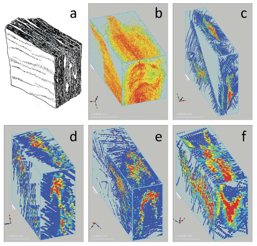
Figure 1. a) An isometric drawing of a hand sample with the cut planes parallel to the principal planes of symmetry as defined by the foliation and fold axes.
Orthorhombic Multiaxial Maximum Intensity Projection block models created from: b) Au values from the Woolwonga gold deposit situated in a tight
closure of an antiform; c, d, e) Au values from three anonymous deposits showing antiformal structural controls; f ) Ag values from the Que River deposit
displaying synformal fold geometry.
• allows quick testing of grade continuity assumptions that and costly high-density ‘big data’. I conclude that the most
can lead to inaccurate resource estimation and result in rewarding low-cost commercial exploration opportunities
catastrophic mine failures are lying dormant—and ready to be discovered—in existing
drilling databases scattered around the world.
• is a much simpler way to comprehend structural controls
of mineral deposits where drilling data are available, even
if the drill core is not oriented and traditional structural
References
Cowan, E.J., Beatson, R.K., Ross, H.J., Fright, W.R., McLennan, T.J.,
data are unavailable Evans, T.R., Carr, J.C., Lane, R.G., Bright, D.V., Gillman, A.J., Oshust,
• allows preliminary structural interpretation at the scale P.A. and Titley, M. 2003. Practical Implicit Geological Modelling.
In: Dominy, S. (ed.) Fifth International Mining Geology Conference
of the deposit, thus helping the geologist make local Proceedings. Australian Institute of Mining and Metallurgy Publication
predictions and test these in the field. Series No 8/2003, p. 89–99.
Applying this technique to archived drill hole assay datasets Cowan, E.J., 2014, ‘X-ray Plunge Projection’— Understanding Structural
Geology from Grade Data. AusIMM Monograph 30: Mineral Resource
will allow exploration targets from historical data to be and Ore Reserve Estimation — The AusIMM Guide to Good Practice,
identified and interpreted, and doesn’t rely on collecting new second edition, p. 207-220.
Gold18 – August 2018 – Perth, Western Australia11 l Artificial Unintelligence—why a simplistic focus on ‘big data’ processing will not result in E. J. Cowan
mineral exploration success and what we can do about it
Financial Post, 2016. Rubicon Minerals Corp shares plunge as miner
slashes its gold resources by 88%. (http://business.financialpost.com/
news/mining/rubicon-minerals-corp-shares-plunge-as-miner-slashes-
its-gold-resources-by-88) [accessed 14 July, 2018].
Hobbs, B.E. and Ord, A., 2018. Nonlinear analysis, kriging, predictions and
forecasting in mineral systems. Gold18@Perth Abstract Volume. AIG
Special Publication, 68: p34-38.
MacKin, J H, 1950. The down-structure method of viewing geological
maps. The Journal of Geology, 58: 55–72.
Peterson, M.S. and Weiss, L.E., 1961. Symmetry concepts in the structural
analysis of deformed rocks. Geological Society of America Bulletin, 72:
841–882.
Wallis, J.W., Miller, T.R., Lerner, C.A. and Kleerup, E.C., 1989. Three-
dimensional display in nuclear medicine. IEEE Trans Med Imaging,
8(4): 297–303.
Biography
JUN Cowan on the first day he became a structural geology consultant in 1999, learned that resource estimation
and ‘geological modelling’ were often conducted by those who had no training in geology, using software more suited
for designing buildings. This anomaly didn’t seem to bother anyone else. Intrigued by this disconnection and frustrated
by ineffective mining software, in 2001 Jun conceived Leapfrog—the first implicit modelling software released for the
mining industry in 2003. He predicted that, through using Leapfrog, within five years the mining industry would see that
structural geology is essential to obtain a deep understanding of all mineral deposits. Some 15 years after the release of
Leapfrog (which he left in 2007), he is still waiting. Jun mission is to lead the mining industry into an age of structural
geological enlightenment, based on the experience he has gained from examining data from more than 600 deposits
worldwide. He is an independent consultant with Orefind, with MSc and PhD degrees in sedimentology and structural
geology from the University of Toronto, and is an Adjunct Senior Research Fellow at Monash University.
Gold18 – August 2018 – Perth, Western Australia12 l Origin of Gold Nuggets in Regolith, Otago Schist, New Zealand D. Craw
Origin of Gold Nuggets in Regolith, Otago Schist,
New Zealand
D. Craw1
The origin of gold nuggets has long been controversial, groundwater alteration developed progressively since then
and this paper does not attempt to address this general (Fig. 1b). The alteration zone is dominated by intense
question. Instead, this paper provides a summary of recent kaolinitic replacement near the regional unconformity
observations on the nature and variations of gold textures, surface, and this grades downwards through variably
both internal and external, and related compositions, from oxidised and clay-altered schist to fresh schist below the
the Mesozoic Otago Schist belt of southern New Zealand. water table. The alteration zone is typically about 50 m
This region has produced abundant gold that has been thick, of which almost half can be predominantly kaolinitic
extracted from regolith and associated sediments from (Fig. 1b). The alteration zone is locally overlain by thin
Cretaceous to Holocene in age. Gold sampled directly Cretaceous-Cenozoic sediments, mostly non-marine, and
from regolith in Otago can be usefully compared to what is groundwater-related alteration has affected many of those
undoubtedly hydrothermal gold from below the regolithic sediments as well as the basement. The altered rocks have
zone, particularly near to the world-class Macraes orogenic been variably uplifted and eroded, with development of a
deposit (Fig. 1a-d). The observations in this paper provide complex regolithic zone that includes altered basement and
some information on the geochemical and mineralogical colluvium (Fig. 1b; Craw et al. 2016).
context for gold mobility in the Otago regolith. The
Alteration has also affected orogenic gold deposits in the
applicability of these observations and inferences to
basement, with extensive oxidative destruction of sulphide
other terranes is not known. The Otago near-surface gold
minerals. It is notable that minor historic mining in these
mobilisation processes appear to be very different from, for
orogenic deposits almost always ceased when excavations
example, Western Australia (e.g., Mann 1984).
penetrated to the unoxidised parts of the deposits, and
The present surface of much of Otago Schist belt was reported grades were considerably higher than those
exposed in the Cretaceous, and an extensive zone of observed in drillholes in fresh schist today (Fig. 1a; Craw
et al. 2015). There is commonly 1-2 orders of magnitude
difference between Au contents in oxidised surficial
mineralised rocks and fresh rocks below ~100 m (Craw
et al. 2015). Equally importantly, the historic miners
extracted coarse free Au particles (Fig. 1c) by gravity, Hg
amalgamation, and/or direct cyanidation. In contrast, ore
from fresh mineralised zones immediately underlying the
oxidised regolith (Fig. 1c) is refractory and occurs as micron
scale inclusions in sulphide minerals (Fig. 1d). The Macraes
mine has now penetrated deeper than 500 m below the
regolith, and has produced nearly 5 Moz of refractory Au
after flotation of the sulphides and further processing to
liberate the Au. The very rare examples of free Au in that
Figure 1. Gold liberation and concentration as a result of long-term large volume of processed rock are typically13 l Origin of Gold Nuggets in Regolith, Otago Schist, New Zealand Dave Craw
groundwaters with elevated Ca2+, HCO3- and SO42- (Craw of the intense clay-altered zone and transported down to the
and Kerr 2017). Minor input of marine aerosols contributes general vicinity of the prevailing water table where it was
some Na+,Cl- and additional SO42- (Craw and Kerr 2017). redeposited and concentrated as coarse particles.
There is sufficient calcite to neutralise acid generated by These processes of gold mbilisation and redeposition were
oxidation of sulphides, even including auriferous sulphides enhanced by evaporative processes in near-surface regolith
in orogenic deposits. Consequently, groundwaters have (Fig. 3a-e). The sulphur-dominated chemistry of the shallow
circumneutral pH, although there is some minor localised groundwaters was locally enhanced by evaporation which
acidification in the immediate vicinity of sulphide-rich rocks increased the concentrations of the waters so that they
(Fig. 2a,b). deposited sulphate minerals (Fig. 3a-d). These minerals
included both ferrous and ferric sulphates, and were
accompanied by partially and fully oxidised arsenic minerals
arsenolite and scorodite (Fig. 3a-e; Craw 2017). In addition
to enhancing the concentrations of the oxidative products
from the sulphide minerals, Au dissolved from the oxidising
sulphides was concentrated and deposited with the sulphate
minerals (Fig. 3b,d).
Figure 2. Summary geochemical diagrams depicting geochemical settings
for gold mobility and redeposition in regolithic environments. (a)
Compilation of experimental gold solubility at room temperature with
various inorganic ligands relvant to groundwaters in regolith (modified
from Craw and Lilly 2016, and references therein). Otago Schist regolithic
gold mobility occurs in sulphur-dominated environments, whereas West
Australian processes may be dominated by chloride-rich environments
(Mann 1984). (b) Eh-pH diagram showing typical groundwater
solution evolution in Otago circumneutral pH regolithic environments
(after Craw and Kerr 2017; Craw 2017).
Under the ambient circumneutral pH and sulphur-rich
conditions of the regolithic environment, Au can be Figure 3. Geochemical processes and minerals that are associated with
mobilised by S-bearing ligands (Fig. 2a). In particular, sulphide oxidation and gold mobility during evaporative processes in
thiosulphate complexes (Au-S2O32-) form when metastable the regolithic environment at Macraes orogenic gold deposit, Otago,
thiosulphate is generated during oxidation of sulphide- New Zealand. Images modified from Craw (2017). (a) SEM image of
hydrothermal pyrite (light grey) with secondary Fe sulphate encrustations
sulphur to sulphate-sulphur (Fig. 2a; Webster 1986). (paler grey). (b) Summary of chemical reactions involving oxidation
Gold can be transported as thiosulphate complexes and of sulphides and evaporation of oxidised groundwater in regolith. (c)
redeposited when the thiosulphate decomposes to SO42-, Close view of evaporative Fe sulphate in a. (d) Gold (white) deposited
or under reducing conditions below the water table (Fig. with evaporative amorphous Fe sulphate on the surface of a secondary
2b). Conversely, Au can be mobilised as Au-HS complexes gold particle. (e) SEM image of an arsenolite crystal intergrown with
under reducing conditions, and redeposited where pH or secondary gold, indicating partial oxidation of arsenopyrite.
redox conditions change (Fig. 2a,b; Webster 1986).
Most gold nuggets in the Otago Schist regolith are
intergrown with, or directly associated with, iron Physical processes, from regolith to
oxyhydroxide (Fig. 1c). These nuggets are found in the
oxidised parts of orogenic deposits only, and occur in
sediments
quartz veins, in associated fault rocks, and in joints within The friable nature of the altered zone on the Otago Schist,
the adjacent host rock up to 2 metres from the principal combined with on-going increase in relief from tectonic
mineralised structures. In addition, some coarse gold uplift, has resulted in progressive downslope movement of
particles occur in similar structural settings immediately debris to form colluvial aprons near to exposed orogenic
below the redox boundary between iron oxyhydroxides deposits. Proximal debris, within a few hundred metres
and primary sulphides. The direct observations on regolith of sources, is typically angular and poorly sorted, with
mineralogy and groundwater geochemistry, coupled with abundant lithic clasts that range from metre-scale boulders
inferences from laboratory experiments on Au solubility, to silty matrix. Farther downstream, the debris becomes
suggest that gold was mobilised from the shallower portions more rounded and eventually more mature with higher
Gold18 – August 2018 – Perth, Western Australia14 l Origin of Gold Nuggets in Regolith, Otago Schist, New Zealand Dave Craw
proportions of quartz-rich clasts. In addition, pre-existing grains are so distorted by deformation that they recrystallise
cover sediments, which are commonly quartz-rich as well, to finer grain sizes that are typically 10-20 microns (Fig. 4
contribute to the apron of colluvium and downstream lower centre) but can be as small as micron-scale (Kerr et
proximal fluvial sediments. These aprons of sediments al. 2017). Further transport-related deformation ultimately
emanate from uplifting slopes in the currently-active leads to almost complete recrystallisation (Fig. 4, lower
Pleistocene-Holocene topography, and similar aprons of right). Flattened flakes are typically almost all recrystallised,
sediments have been formed in the past, to be uplifted with only remnants of original grains in their cores (Craw et
and recycled several times over at least since the middle al. 2017).
Cenozoic (Fig. 4). Primary (hydrothermal) gold in Otago Schist orogenic
deposits generally has 5-10 wt% Ag, and nuggets formed in
the overlying regolith have between 0 and 8 wt% Ag (Craw
and Kerr 2017). The processes of deformation-induced
recrystallisation of gold to finer grain sizes are accompanied
by loss of Ag (Fig. 4, lower centre and right). This Ag loss
initially occurs on the rims of particles, but with increased
deformation and recrystallisation, all, or almost all of the Ag
can be expelled from the gold structure (Craw et al. 2017).
Consequently, there is a general increase in gold fineness
(lower Ag content) with increased physical tumbling,
either because of longer distance of transport, or because of
repeated recycling (Fig. 4).
In addition to the physical and chemical processes associated
with colluvial and proximal alluvial transport (as outlined
above), minor deposition (micron scale) of authigenic gold
Figure 4. Summary of processes that affect coarse secondary gold as uplift occurs on the exterior surfaces of many gold particles (Craw
and erosion transfers particles from oxidised orogenic sources into the
and Lilly 2016; Craw et al. 2016, 2017; Craw and Kerr
sedimentary system that is in turn uplifted and eroded with recycling
of gold. Images modified from Hesson et al. (2016); Craw et al. (2017), 2017). This authigenic gold apparently forms under almost all
Stewart et al. (2017), and McLachlan et al. (2018). Angular crystalline conditions within the regolith and the associated sedimentary
secondary nuggets (left) become physically modified during transport environments, and is commonly accompanied by authigenic
(centre and right). Electron backscatter diffraction (EBSD) images at clay formation (Craw and Lilly 2016; Craw and Kerr 2017).
bottom show the evolution (from left to right) of internal gold textures These overgrowths contain no significant Ag, and contribute
during transport, with associated loss of Ag during deformation-induced slightly to the higher fineness of deformed particles (Craw et
recrystallisation.
al. 2017). The gold overgrowths are mostly irregular in shape,
but are locally crystalline (hexaconal and triangular plates;
Coarse gold particles formed in the regolith by the processes dodecahedra). Microbiological mediation of gold overgrowth
described above have been progressively liberated from their formation is suspected in many cases (Craw and Kerr 2017;
sources and physically transported down-slope with the Kerr and Craw 2017).
aprons of silicate debris (Fig. 4). Angular, locally crystalline
(e.g., Fig. 4, top left), nuggets become rounded within References
the first few hundred metres, and the largest nuggets are Craw D 2017. Placer gold and associated supergene mineralogy at Macraes
typically not moved farther than that in any one sedimentary Flat, East Otago, New Zealand. New Zealand Journal of Geology and
cycle. However, when uplifted and recycled, additional Geophysics 60: 353-367.
rounding is imposed and nuggets can approach ellipsoidal Craw D, Lilly K 2016 Gold nugget morphology and geochemical
environments of nugget formation, southern New Zealand. Ore Geology
shapes (e.g., Fig. 4, top right). With futher transport or
Reviews 79: 301-315.
progressive recycling, or both, particles become flattened and
Craw D, MacKenzie D 2016. Macraes gold deposit, New Zealand.
eventually form thin discoidal flakes (Fig. 4). SpringerBriefs in World Mineral Deposits. (Ed: Camprubi A, Gonzalez
These external changes to the nuggets are also reflected Jimenez A, Gonzalez F, Slack F), ISBN 978-3-319-35158-2, 130 pp.
in internal textural and compositional changes. Initially, Craw D, Kerr G 2017. Geochemistry and mineralogy of contrasting
regolith-formed nuggets have coarse internal grain size supergene gold alteration zones, southern New Zealand. Applied
Geochemistry 85: 19-34.
(typically hundreds of microns; Fig 4, lower left). Initial
stages of transport of the nuggets cause minor distortion Craw D, MacKenzie DJ, Grieve P 2015. Supergene gold mobility in
orogenic gold deposits, Otago Schist, New Zealand. New Zealand
of the crystal lattices of these large grains, as indicated by Journal of Geology and Geophysics 58: 123-136.
the perturbations in EBSD colours in Fig. 4 (lower left
Craw D, Hesson M, Kerr G 2016. Morphological evolution of gold nuggets
and centre). Physical tumbling within the colluvium and in proximal sedimentary environments, southern New Zealand. Ore
downstream fluvial sediments results in particle rims whose Geology Reviews 80: 784-799.
Gold18 – August 2018 – Perth, Western Australia15 l Origin of Gold Nuggets in Regolith, Otago Schist, New Zealand Dave Craw
Craw D, McLachlan C, Negrini M, Becker N. 2017. Quantification and
prediction of bulk gold fineness at placer gold mines: A New Zealand
example in: Dominy S; OÇonner L; Parbhakar-Fox A (eds), Special
Issue “Geometallurgy”, Minerals 7, 226; doi:10.3390/min7110226
Hesson M, Stewart J, Stephens S, Kerr G, Craw D 2016. Gold nuggets in
proximal placers, Old Man Range, Central Otago, in: Mineral Deposits of
New Zealand: Exploration and Research. (ed, A.B. Christie). Australasian
Institute of Mining and Metallurgy Monograph 31: 359-366
Kerr G, Craw D 2017. Mineralogy and geochemistry of biologically-
mediated gold mobilisation and redeposition in a semiarid climate,
southern New Zealand. in: Reith F; Shuster J (eds), Special Issue
“Geomicrobiology and biogeochemistry of precious metals”, Minerals 7, 147,
doi:10.3390/min7080147
Kerr G, Falconer D, Reith F, Craw D 2017. Transport-related mylonitic
ductile deformation and shape change of alluvial gold, southern New
Zealand. Sedimentary Geology 361: 52-63.
Mann AW 1984. Mobility of gold and silver in lateritic weathering profiles:
Some observations from Western Australia. Economic Geology 79: 38-49.
McLachlan C, Negrini M, Craw D 2018. Gold and associated minerals in
the Waikaia placer gold mine, Northern Southland, New Zealand, New
Zealand Journal of Geology and Geophysics 61: 164-179.
Stewart J, Kerr G, Prior D, Halfpenny A, Pearce M, Hough R, Craw D
2017. Low temperature recrystallisation of alluvial gold in paleoplacer
deposits. Ore Geology Reviews 88: 43-56.
Webster JG 1986. The solubility of Au and Ag in the system Au–Ag–S–
O2–H2O at 25 °C and 1 atm. Geochimica et Cosmochimica Acta 50:
245–255.
Biography
Dave Craw is Professor of Economic Geology at University of Otago, New Zealand. For 35 years he has been
researching tectonic, geochemical and mineralogical aspects of gold mobilisation and concentration in hypogene,
supergene, and sedimentary placer environments around the world. He received his PhD from University of Otago
in 1982.
Gold18 – August 2018 – Perth, Western Australia16 l Geophysical exploration for orogenic gold mineral systems Mike Dentith
Geophysical exploration for orogenic gold mineral
systems
Mike Dentith1
The established role for geophysics in exploration for An alternative way of conceptualising mineral systems
orogenic gold is primarily one of geological mapping is that of McCuaig and Hronsky (2014) who describe
(Dentith and Mudge, 2014). With structure the major four ‘critical elements’ to a mineral system. (i) Fertility
control on the occurrence of mineralisation aeromagnetic, is roughly equivalent to identifying a source of metals
and to a lesser extent, gravity data, have been widely etc. (ii) Favourable whole lithospheric architecture is related
used to in this role. Other prospect-scale controls such to fluid pathways in the sense that the movement of the
as preferred host rock types, most commonly iron- fluids is controlled by large-scale geological structure. For
rich lithotypes, and contacts been units with different example, ascending magmas are deflected to the margins
rheological properties, also lend themselves to geophysics of regions of stable continental lithospheric mantle. Brines
deployed in a mapping role. Also, there have been tend to flow through regions of increased porosity and
various attempts, with generally unconvincing results, permeability, which are often fault zones whose location is
to map potassium-rich alteration using radiometrics. related to large scale geological structure. (iii) Favourable
Inconsistencies in associations between gold mineralisation (transient) geodynamics is a consequence of McCuaig and
and various types and quantities of metal sulphides and Hronsky’s proposal that ore-forming fluid-flow systems
oxides make deposit-scale targeting using electrical and are examples of self-organising critical systems. Their
electromagnetic geophysical methods problematic. model for fluid flow involves generating extreme pressure
The concept of a mineral system leads to reconsideration gradients to produce the concentrated flow of large
of the way geophysical methods are deployed in mineral volumes of fluid. This is achieved with a localised barrier
exploration, including in exploration for orogenic gold. to fluid flow. Behind this barrier there is a high-pressure
A mineral system represents a much larger target than brine or magma reservoir. The barrier is periodically
an individual mineral deposit and the idea provides a breeched, allowing short-term flow of mineralising fluids.
useful conceptual framework in which to follow the (iv) Preservation of the primary depositional zone.
standard exploration practice of progressively reducing the
exploration search space. As demonstrated below, there Petrophysics of alteration
is evidence that geophysical methods can detect different In hydrothermal mineral systems such as orogenic gold, all
components of the mineral system, including source zones, of the mineral system components described above are zones
flow conduits and also fluid reservoirs. This suggests a of fluid-rock interaction and hence sites of hydrothermal
whole new set of geophysical exploration targets at the alteration. The ability of geophysical methods to detect the
district-scale and above. various components critically depends on the size of the
zone of altered rock and the changes in physical properties
Mineral systems caused by the alteration.
Different authors have defined the various components of There is substantial evidence that alteration can have
a mineral system in slightly different ways although many profound consequences for rock physical properties but
describe hydrothermal and orthomagmatic systems as there is a lack of detailed studies in this context, including
comprising a source of fluids, metals and other elements alteration associated with orogenic gold systems. Results
and a pathway along which fluids transport the metals to to date suggest seismic and electrical properties may
a location where they are precipitated via some kind of be the most useful physical properties, based on, (i) the
trapping mechanism (source-pathway-trap). Depending magnitude of the changes in physical properties, (ii)
on the type of fluids and metals involved, the trap may the ability of seismic and electromagnetic methods to
comprise one or more of chemical reactions with wall penetrate to the depths where mineral system components
rocks, fluid mixing, changes in P, T, pH and redox state. are expected (see below).
1. Centre for Exploration Targeting, School of Earth Sciences, The University of Western Australia Corresponding author: Mike Dentith
Email: michael.dentith@uwa.edu.au
Gold18 – August 2018 – Perth, Western AustraliaYou can also read