Prescott Hall Drainage Study Project No. 22-012-3 - Public Workshop #1 May 12, 2022 - City of Newport
←
→
Page content transcription
If your browser does not render page correctly, please read the page content below
Prescott Hall
Drainage Study
Project No. 22-012-3
Public Workshop #1
May 12, 2022
Introductions
▪ City of Newport
    − Rob Schultz, PE – Director of Utilities
▪ RIDOT
    − Jody Richards, PE – Pell Bridge Improvements Project Manager
▪ Jacobs
    −   Peter von Zweck, PE – Project Principal
    −   McKenzie Banahan, PE – Project Manager
    −   Andrea Braga, PE – Water Resources Service Lead
    −   Erin O’Shea, EIT – Project Engineer

2                                                                    ©Jacobs 2022
Agenda
▪   Project Objective
▪   Background
▪   Survey Results
▪   Prescott Hall Study Area
▪   Scope of the Current Drainage Study
▪   Next Steps
▪   Open Discussion

3                                         ©Jacobs 2022
Project Objective

4
Project Objective
▪ Problem: Historic drainage and
  flooding issues in the Prescott Hall
  neighborhood during high intensity
  rainfall events and extreme high tides
▪ Objective: Identify sources of flooding,
  evaluate mitigation alternatives,
  develop recommendations including
  cost estimates
▪ Outcome: Short-term and long-term
  control recommendations to reduce the
  magnitude and frequency of flooding

5                                            ©Jacobs 2022
Background

6
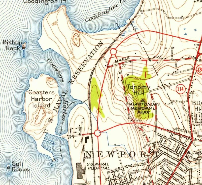
Watershed History
▪ Substantial residential development
  in the upper reaches in 1920s and
  1930s
▪ Includes Malbone and Prescott Hall    Discharge
  neighborhoods                         to Harbor

▪ Open channel flow in lower reaches
                                                            Malbone
▪ Discharge to Coasters Harbor
                                                            Channel

                                                Low Point

7                                                                 ©Jacobs 2022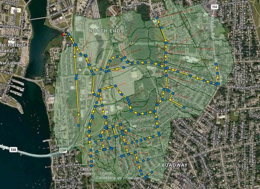
Watershed History
▪ Pell Bridge constructed in 1960’s
  combined with other development over
  the years has disrupted natural overland
  flow path
▪ Current storm infrastructure was generally
  designed ±50 years ago and is undersized
  for current conditions
▪ Historic flooding following precipitation
  events and coinciding with high tide
  create a compound problem
▪ Sea level rise and more intense and          https://www.dot.ri.gov/projects/pellbridgeramps/
  frequent storms are already being
  experienced, more are projected to come

8                                                                                                 ©Jacobs 2022
Past Flooding Events – August 2012
▪ August 15, 2012
    − 1.25 inches in 0.5 hours
    − 2-year return frequency (50% chance of occurring
      in any given year)
    − Flood depth reported at Prescott Hall & Garfield St:                 Garfield St. at Homer St., looking west
                                                                                      August 15, 2012
      approximately 3 feet

                                      Storm Drain Overflow
                            Homer St. at Southmayd St., looking north   Prescott Hall Rd at Garfield St, looking north
                                         August 15, 2012                              August 15, 2012

9                                                                                                                    ©Jacobs 2022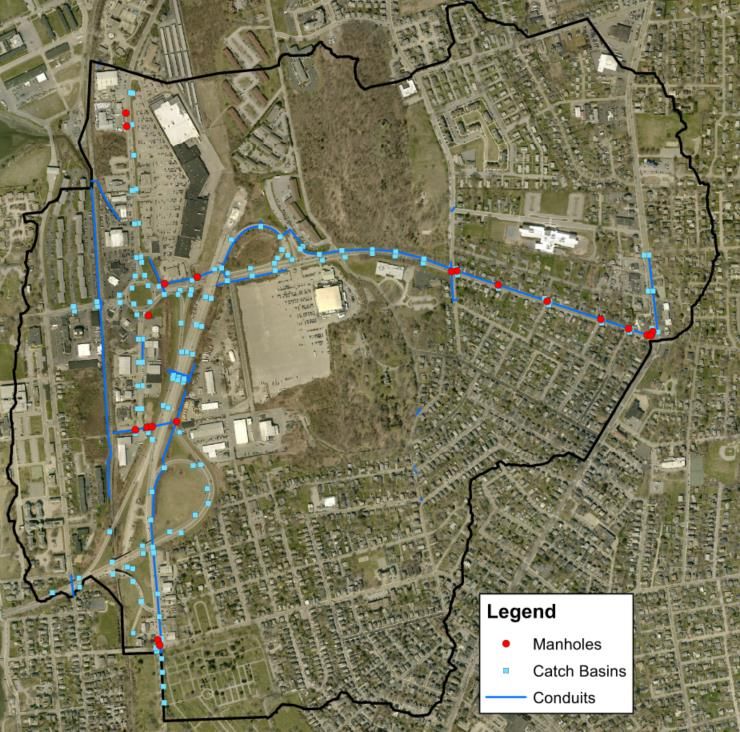
Past Flooding Events - Tropical Storm Ida
▪ September 1-2, 2021
▪ 6.34 inches rain in 24 hours
▪ Comparable to 100-yr, 6-hr return frequency (1% chance of
  occurring in any given year)
▪ Heaviest rainfall between 1 AM – 5 AM on Sep 2, 2021
  − Peak observed tide coincident with peak precipitation
    intensity at 3:30 AM

                     Resident Photo – 34 Prescott Hall Rd
                          September 2, 2021, 4 AM

10                                                            ©Jacobs 2022
Survey Results 11 ©Jacobs 2022
Survey Results
▪ Total responses as of May 11th: 8

                Which of the following best describes you?

                                                                           If you have been in the area at least 10 years, how
       Interested stakeholder                                                   would you describe the change in flooding
                                                                                   magnitude/frequency since 2012?

                                                                                  N/A
        Local business owner                                                Unknown
                                                                      Stayed the same
                                                                            Worsened
     Resident/property owner                                                Improved
                                                                                        0            1               2              3
                                                                                                         Responses
                                0%   20%   40%    60%    80%   100%

12                                                                                                                               ©Jacobs 2022
Survey Results
▪ Total responses as of May 11th: 8
If resident/owner, what types of flooding have you How frequently have you observed flooding?
observed in your area? Select all that apply
N/A Other
Other
Once every five years
Safety/Access issues
Yard flooding Approximately once per year
Street flooding
Several times per year
Basement flooding
0% 20% 40% 60% 80% 100% 0% 20% 40% 60% 80% 100%
13 ©Jacobs 2022Survey Results
▪ Total responses as of May 11th: 8
Which of the following best describes the depth of street
flooding observed during Tropical Storm Ida?
N/A
More than 2 feet
1.5 feet – 2 feet
1 foot – 1.5 feet
6 inches – 1 foot
Less than 6 inches
0% 20% 40% 60% 80% 100%
14 ©Jacobs 2022Prescott Hall Study Area 15
Prescott Hall Study Area Outfall to
Harbor
▪ Watershed boundaries
− 586 acres
− 50% impervious cover
− 6% average slope
▪ Max elevation: 157.8 ft
▪ Min elevation: 0.8 ft
− Primarily silty loam and sandy loam
soil types
− Shallow groundwater
▪ Existing drainage infrastructure
− City storm drain outlets to RIDOT
drainage channels and culverts
− Outfalls to harbor at elevation 1 ft
− No tide gates
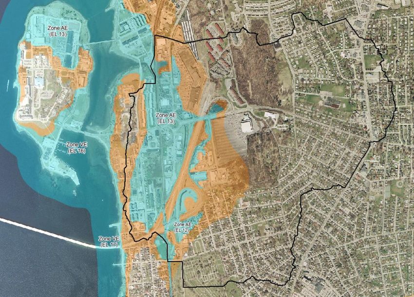
16 ©Jacobs 2022FEMA Flood Boundaries
100-year Flood Zone (1%)
500-year Flood Zone (0.2%)
Drainage Area
▪ Watershed lies within
the 100-year and 500-
year floodplains
▪ FEMA map does not
take into consideration
sea level rise or storm
surge
17 ©Jacobs 2022Previous Drainage Study Findings - 2014
▪ Study Scope: drainage analysis and flood assessment of the storm drain system in
both the Malbone and Prescott Hall subcatchments
▪ Study Findings for Prescott Hall:
− Increased maintenance and cleaning of the City and State’s channels and culverts
estimated to reduce flooding for design storm by 24%
− Other alternatives such as RIDOT channel and culvert upgrades and/or a new Halsey
Street culvert estimated to reduce flooding for design storm by >90%
*Flood reduction results shown are for 10-year, 6-hour design storm
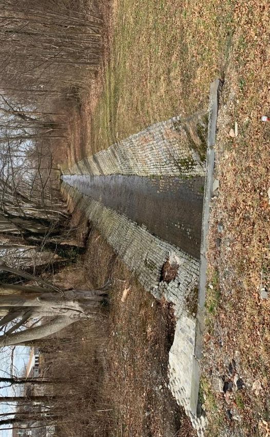
18 ©Jacobs 2022Previous Drainage Study Findings - 2014
▪ City’s Actions
− Malbone Channel cleared out in 2017
− 42” storm drain from Prescott Hall Road inspected
and cleaned as needed
− 48” storm drain from Malbone Channel outlet
inspected and cleaned as needed
− All catch basins are inspected at Malbone Channel
least once annually; catch basins Restored in 2017, maintenance ongoing; photo taken February 2022
prone to clogging inspected more
frequently prior to significant
events
− Several catch basins replaced in
the Prescott Hall area since 2014
Catch Basins at Prescott Hall Rd & Garfield St Catch Basins at Hillside Ave & Bedlow Ave
Replaced in 2015; photo taken February 2022 Replaced in 2017-2018; photo taken February 2022
19 ©Jacobs 2022City Drainage Infrastructure Outlet
Low Point
20 ©Jacobs 2022RIDOT Drainage Channels and
RIDOT Drainage Infrastructure Culverts; photos taken February 2022
12-ft Box Culvert Under Railroad
Twin 60” Culverts Under JT Connell Hwy
Twin 60” Culverts Under Admiral Kalbfus
Drainage Channel Along RI-238
21 ©Jacobs 2022Scope of Current Drainage Study 22
Project Approach
▪    Develop detailed understanding of the contributing factors to flooding
▪    Detail limits of contributing existing storm drain infrastructure
▪    2D hydraulic modeling of study area
▪    Development of potential mitigation alternatives
     −   Short-term (1-3 years)/RIDOT Pell Bridge Improvements project
     −   Long-term (3+ years)
     −   Conceptual designs
     −   Levels of control
     −   Cost estimates
     −   Implementation schedules
▪ Public involvement throughout, including development and selection of mitigation
  alternatives

23                                                                            ©Jacobs 2022
Key Priorities and Issues
▪ Improve conveyance
▪ Reduce magnitude and frequency of flooding
▪ Improve public health and safety
▪ Adapt for climate change and sea level rise https://www.newportri.com/story/news/2020/08/26/rising-concern/113804768/
▪ Synergy with ongoing Pell Bridge
Improvements Project
https://www.newportmansions.org/about-us/press/press-releases/the-newport-pell-bridge-turns-50
24 ©Jacobs 2022Hydrologic and Hydraulic Modeling
▪ Tool utilized to simulate rainfall runoff and
predict extent of flooding
▪ Key components and inputs:
− storm drain infrastructure
− topography (elevation) data
− site-specific soil and infiltration data
− precipitation and tidal data
▪ Model is first validated against past events to
confirm predictions match reality
▪ Potential improvements are then added to
the model to test the effectiveness of
different alternatives and identify the most
cost-efficient solution
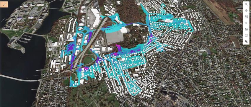
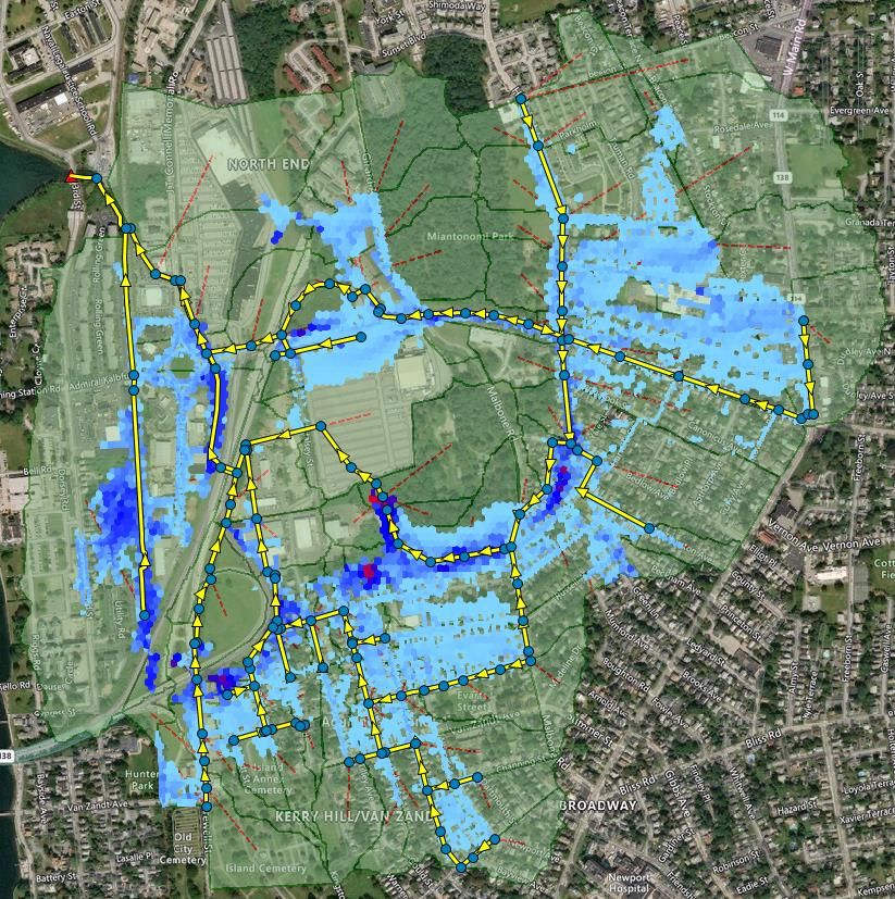
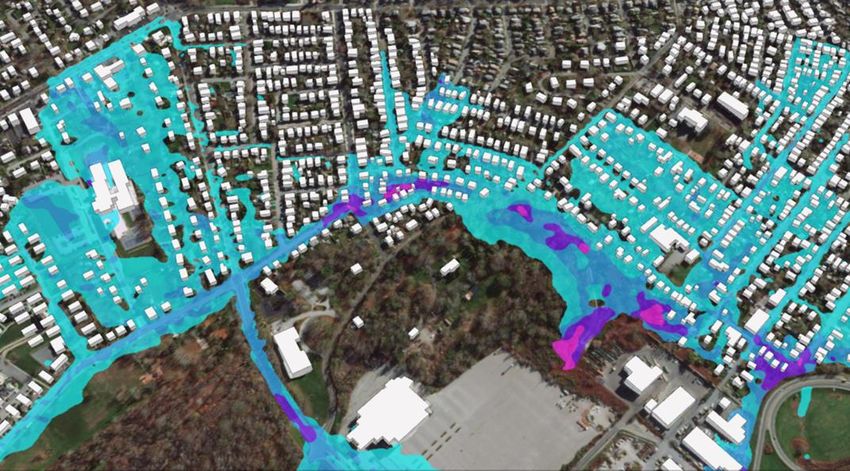
25 ©Jacobs 2022Existing Conditions Model Results
▪ August 15, 2012 storm event
▪ Cells are sized at an average of 900 ft 2
▪ Maximum ponding depth in each cell is
shown
Hillside Ave &
Bedlow Ave
2.37 ft
Prescott Hall &
Garfield St
2.33 ft
26 ©Jacobs 2022Existing Conditions Model Results ▪ Conditions shown from 8/15/2012 7:00 AM to 8/16/2012 12:00 AM 27 ©Jacobs 2022
Existing Conditions Model Results   Depth (ft)

28                                    ©Jacobs 2022
Existing Conditions Model Results

                                    Looking Southeast towards the Newport Grand Casino

 Depth (ft)

                                          Looking South towards Prescott Hall Rd

29                                                                                 ©Jacobs 2022
N
Garfield Street
W. Narragansett
Flood Profile
Ave.
30 ©Jacobs 2022Prescott Hall Road Flood Profile 31 ©Jacobs 2022
Prescott Hall Road to Harbor Profile

     Prescott Hall Rd   Cross under RI-138   Cross under Admiral     Cross under
                                                 Kalbfus Rd        JT Connell Hwy
                                                                                    Outlet to
                                                                                     Harbor

32                                                                                              ©Jacobs 2022
Next Steps 33
Images from: Reconstruction of the Pell Bridge

Pell Bridge Approach Improvements   Approaches presentation dated 10/27/20
                                    https://www.dot.ri.gov/projects/pellbridgeramps/

34                                                                      ©Jacobs 2022
Next Steps
▪ May-June 2022
− Validate hydraulic model with Tropical Storm Ida (we need your input!)
− Develop baseline “proposed conditions” model to include Pell Bridge improvements
− Develop potential mitigation alternatives for discussion
− Hold second public workshop on June 23, 2022 to review model results and discuss
mitigation measures
▪ July-August 2022
− Evaluate potential mitigation alternatives using model
− Develop conceptual cost estimates
− Hold third public workshop in August 2022 to review model results and obtain feedback
on recommended mitigation alternatives
35 ©Jacobs 2022Additional Opportunities for Stakeholder Involvement ▪ If you haven’t already, please complete the survey at: https://www.surveymonkey.com/r/5TYBZ32 ▪ Additional photos and information can be sent to Erin O’Shea at erin.oshea@jacobs.com ▪ Public Workshop #2 on June 23, 2022 ▪ Public Workshop #3 in August 2022 ▪ Thank you for the information provided so far! 36 ©Jacobs 2022
Stakeholder Discussion
▪ Any key concerns and/or priorities not captured?
▪ Any additional dates of significant flooding to be used in the study?
▪ Additional comments?

37                                                                        ©Jacobs 2022
Thank you!
You can also read