Investigation of the Kinematic PPP-AR Positioning Performance with Online CSRS-PPP Service
←
→
Page content transcription
If your browser does not render page correctly, please read the page content below
Investigation of the Kinematic PPP-AR Positioning Performance with
                             Online CSRS-PPP Service

      Salih ALCAY, Omer Faruk ATIZ, Sermet OGUTCU, Ibrahim KALAYCI, Turkey

   Key words: CSRS-PPP-AR, CSRS-PPP-FLOAT, GNSS, PPP

   SUMMARY

   The Global Navigation Satellite System (GNSS) has been widely used for many years as it
   provides precise positioning. In general, relative or absolute positioning methods are used for
   GNSS. The precise point positioning (PPP), which is an absolute positioning technique has
   become more practical with online data processing services. The main drawback of PPP
   technique is that it needs a long convergence time to achieve millimeter level accuracy. With
   the recently popular PPP with ambiguity resolution (PPP-AR), the positioning accuracy can be
   improved. However, the ambiguity resolution in PPP can only be possible with additional
   hardware biases which are previously computed from a network. Among the online GNSS data
   processing services, CSRS-PPP (The Canadian Spatial Reference System-PPP) provides
   reliable and robust solutions. At the end of 2020, CSRS-PPP updated its software, and it has
   begun to give ambiguity-fixed solutions. In this study, the kinematic positioning performance
   of CSRS-PPP was examined. Thus, the improvements of the CSRS-PPP-AR solutions were
   analyzed comparing to the previous version (CSRS-PPP-FLOAT).

Investigation of the Kinematic PPP-AR Positioning Performance with Online CSRS-PPP Service (11018)
Salih Alcay, Omer Faruk Atiz, Sermet Ogutcu and Ibrahim Kalayci (Turkey)
FIG e-Working Week 2021
Smart Surveyors for Land and Water Management - Challenges in a New Reality
Virtually in the Netherlands, 21–25 June 2021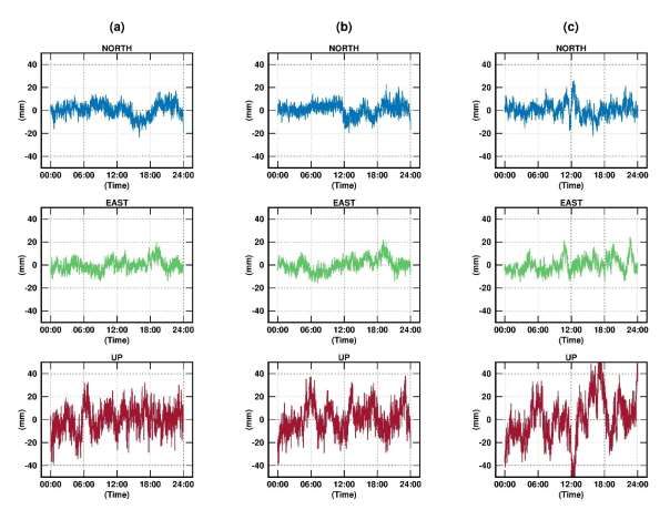
Investigation of the Kinematic PPP-AR Positioning Performance with
                             Online CSRS-PPP Service

      Salih ALCAY, Omer Faruk ATIZ, Sermet OGUTCU, Ibrahim KALAYCI, Turkey

       1. INTRODUCTION

   The Global Navigation Satellite System (GNSS) has been used in precise positioning for
   decades. Besides, the precise point positioning (PPP) method has been used in many scientific
   studies to determine plate or structural movements (Hefty and Gerhatova 2012; Tang et al.
   2017). The PPP technique can provide millimeter level accuracy by using the precise satellite
   orbit and clock products after a convergence time (Zumberge et al. 1997; Kouba and Héroux
   2001). Traditionally, the PPP method offers an ambiguity-float solution due to the complexity
   of PPP ambiguity fixing. The ambiguity fixing for PPP requires additional phase-clock bias
   products calculated from the network. These products are generated by International GNSS
   Service (IGS) analysis centers such as CODE (Center for Orbit Determination in Europe),
   NRCan (Natural Resources Canada), and Wuhan University. Different analysis centers of IGS
   perform different strategies for obtaining PPP-AR (PPP with Ambiguity Resolution) products
   and some of them are not publicly available. Furthermore, the PPP processing software should
   be consistent with the PPP-AR products since they differ in obtaining approaches (Banville et
   al. 2020). However, for online GNSS data processing services such as CSRS-PPP (Canadian
   Spatial Reference System-PPP) only observation data need to be submitted (URL-1). CSRS-
   PPP is an online PPP processing service managed by NRCan since 2003 (Tétreault et al. 2005).
   Many studies have been conducted referring to CSRS-PPP, including kinematic positioning and
   tropospheric delay estimation (Alkan et al. 2015; Krasuski et al. 2018; Mendez Astudillo et al.
   2018). Accordingly, the robustness of the CSRS-PPP has been proven. Moreover, with
   upgrading CSRS-PPP to PPP-AR at the end of 2020, estimating coordinates via the PPP-AR
   method has become easier. The new implementation of the software utilizes the ambiguity
   resolution on the GNSS data collected after 1 January 2018. For the data before 2018, CSRS-
   PPP uses traditional IGS final precise products. In this study, the kinematic positioning
   performance of the recently upgraded CSRS-PPP service was investigated. For this purpose,
   three daily data of the KNY1 station in 2017 and 2018 were processed. The results were
   analyzed in terms of positioning accuracy.

       2. METHOD

   For examining the kinematic positioning performance of the upgraded CSRS-PPP service, the
   data of KNY1 station of the Turkish CORS-TR network was used. The observation data belong
   to the DOY 1, 2, and 3 in 2018 were processed since the CSRS-PPP utilizes the ambiguity
   resolution after 1 January 2018. In order to compare the ambiguity-fixed solutions with
   ambiguity-float solutions, DOY 363, 364, and 365 in 2017 were used as they are nearest days
   to PPP-AR processing days. The location of KNY1 station is shown in Figure 1. The

Investigation of the Kinematic PPP-AR Positioning Performance with Online CSRS-PPP Service (11018)
Salih Alcay, Omer Faruk Atiz, Sermet Ogutcu and Ibrahim Kalayci (Turkey)
FIG e-Working Week 2021
Smart Surveyors for Land and Water Management - Challenges in a New Reality
Virtually in the Netherlands, 21–25 June 2021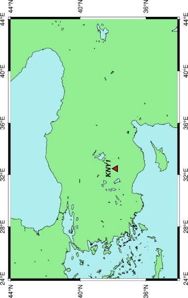
observation data interval was used as 30 seconds. While the IGS Final clock and orbit products
   were used for CSRS-PPP-FLOAT solutions, NRCan/IGS Final products were used in CSRS-
   PPP-AR processes.

   Figure 1. The location of KNY1 station

   For ambiguity resolution in the PPP, it is necessary to estimate the uncalibrated hardware delay
   (UHD) biases originating from both receivers and satellites. The IGS analysis centers perform
   different strategies for estimating phase/clock biases such as “integer clock” (Laurichesse et al.
   2009), “uncalibrated phase delays” (Ge et al. 2008), and “decoupled clock model” (Collins et
   al. 2010). The AR implementation of the CSRS-PPP service is based on undifferenced
   measurements as described to “decoupled clock model” in the work of Collins et al. 2010.
   Moreover, the NRCan produces and uses phase/clock bias products consistent with CSRS-PPP.

   Although CSRS-PPP only performs AR for GPS satellites, GLONASS satellites - as ambiguity-
   float- can be used for estimating rover coordinates. Hence, GLONASS was included in the
   processes to take advantage of additional satellites. Besides the kinematic processes, each
   observation data was processed in the static mode in the same way. The kinematic results were
   compared according to the static results as ground truth.

Investigation of the Kinematic PPP-AR Positioning Performance with Online CSRS-PPP Service (11018)
Salih Alcay, Omer Faruk Atiz, Sermet Ogutcu and Ibrahim Kalayci (Turkey)
FIG e-Working Week 2021
Smart Surveyors for Land and Water Management - Challenges in a New Reality
Virtually in the Netherlands, 21–25 June 2021
3. RESULTS

   The kinematic results belong to six days at total, converted to the topocentric coordinate system
   (north, east, and up). The static results were used as the ground truth. The coordinate time series
   of CSRS-PPP-FLOAT solutions for each coordinate component is shown in Figure 2.

   Figure 2. The coordinate time series of ambiguity-float solutions DOY 363 (a), DOY 364 (b),
   and DOY 365 (c) in 2017

   According to Figure 2, ambiguity-float solutions in the north and east components in the range
   of -20.0/+20.0 mm. However, the up component is worse as expected. In a similar way, the
   ambiguity-fixed solutions were obtained. The percentages of fixed ambiguities are provided in
   Table 1.

Investigation of the Kinematic PPP-AR Positioning Performance with Online CSRS-PPP Service (11018)
Salih Alcay, Omer Faruk Atiz, Sermet Ogutcu and Ibrahim Kalayci (Turkey)
FIG e-Working Week 2021
Smart Surveyors for Land and Water Management - Challenges in a New Reality
Virtually in the Netherlands, 21–25 June 2021
Table 1. The percentages of fixed ambiguities
DOY (2018) Static Kinematic
1 % 99.24 % 99.32
2 % 99.94 % 99.94
3 % 99.46 % 99.93
As seen in Table 1, almost all phase ambiguities were fixed in both static and kinematic
processes. The coordinate time series of CSRS-PPP-AR solutions for each coordinate
component is shown in Figure 3.
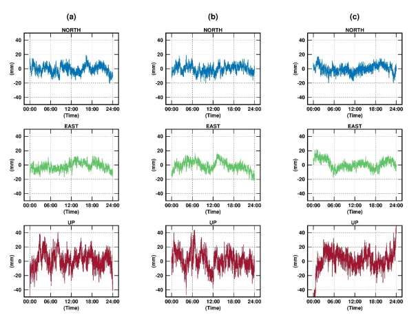
Figure 3. The coordinate time series of ambiguity fixed solutions DOY 1 (a), DOY 2 (b), and
DOY 3 (c) in 2018
As shown in Figure 3, the time series are more smoothed in all components. Particularly, the
improvement in the east component is slightly better. For a better understanding of the results,
some statistical parameters were examined. The absolute maximum, mean, standard deviation
(std), and root mean square error (RMSE) values were computed and provided in Tables 2-3.
Investigation of the Kinematic PPP-AR Positioning Performance with Online CSRS-PPP Service (11018)
Salih Alcay, Omer Faruk Atiz, Sermet Ogutcu and Ibrahim Kalayci (Turkey)
FIG e-Working Week 2021
Smart Surveyors for Land and Water Management - Challenges in a New Reality
Virtually in the Netherlands, 21–25 June 2021Table 2. The statistical parameters for ambiguity-float solutions
DOY (2017) Parameter N (mm) E (mm) U (mm)
Abs. max 20.90 16.80 50.20
Mean -0.67 -1.86 1.84
363
Std 5.90 5.44 12.24
RMSE 5.94 5.75 12.38
Abs. max 19.80 22.30 47.20
Mean -0.54 -1.09 1.19
364
Std 5.67 6.61 12.15
RMSE 5.70 6.70 12.21
Abs. max 19.90 21.70 88.70
Mean -0.39 1.25 0.92
365
Std 5.68 6.41 14.40
RMSE 5.69 6.53 14.43
According to the Table 2, the RMSE values of the north and east components are between 5.69/
5.94 mm and 5.75/ 6.70 mm, respectively. In addition, the RMSE values of the up component
are in the range of 12.21/ 14.43 mm. The same statistical parameters were calculated for the
ambiguity-fixed results. The statistical parameters for PPP-AR solutions are given in Table 3.
Table 3. The statistical parameters for PPP-AR solutions
DOY (2018) Parameter N (mm) E (mm) U (mm)
Abs. max 23.30 19.50 39.30
1 Mean 0.30 0.13 -0.05
Std 5.88 5.88 10.89
RMSE 5.89 4.91 10.88
Abs. max 22.90 22.10 39.70
2 Mean 0.61 0.25 0.68
Std 5.41 5.72 12.09
RMSE 5.44 5.73 12.11
Abs. max 26.00 24.40 63.20
3 Mean 0.59 0.08 0.62
Std 6.27 6.28 18.70
RMSE 6.29 6.28 18.71
According to Table 3, the RMSE values of the north and east components are in the range of
5.44/ 6.29 mm and 4.91/ 6.28 mm, respectively. However, the maximum RMSE is 18.71 mm
in the up component of DOY 3. When the mean values are analyzed, both options of CSRS-
PPP showed similar results in the north component, while the PPP-AR significantly improved
the results in the east and up components.
Investigation of the Kinematic PPP-AR Positioning Performance with Online CSRS-PPP Service (11018)
Salih Alcay, Omer Faruk Atiz, Sermet Ogutcu and Ibrahim Kalayci (Turkey)
FIG e-Working Week 2021
Smart Surveyors for Land and Water Management - Challenges in a New Reality
Virtually in the Netherlands, 21–25 June 20214. CONCLUSION
In this study, the kinematic positioning performance of the latest version of CSRS-PPP was
analyzed. The results of this study showed that the implementation of ambiguity resolution to
CSRS-PPP improved the results. In terms of mean values, the ambiguity resolution significantly
contributed to the east and up components. Consequently, the new CSRS-PPP online service
can easily be used for PPP-AR kinematic positioning requirements.
REFERENCES
Alkan, R. M., İlçi, V., Ozulu, İ. M., & Saka, M. H. 2015. A comparative study for accuracy
assessment of PPP technique using GPS and GLONASS in urban areas. Measurement,
69, 1-8.
Banville, S., Geng, J., Loyer, S., Schaer, S., Springer, T., & Strasser, S. 2020. On the
interoperability of IGS products for precise point positioning with ambiguity resolution.
Journal of geodesy, 94(1), 1-15.
Collins, P., Bisnath, S., Lahaye, F., and Héroux, P. 2010. “Undifferenced GPS Ambiguity
Resolution Using the Decoupled Clock Model and Ambiguity Datum Fixing.” Journal of
the Institute of Navigation 57 (2): 123–135.
Ge, M., Gendt, G., Rothacher, M., Shi, C., and Liu, J. 2008. “Resolution of GPS Carrier-Phase
Ambiguities in Precise Point Positioning (PPP) with Daily Observations.” Journal of
Geodesy 82 (7): 389–399.
Hefty, J., & Gerhatova, L. U. 2012. Potential of precise point positioning using 1 Hz GPS data
for detection of seismic-related displacements. Acta Geodynamica et Geomaterialia, 9(3),
167.
Kouba, J., and Héroux, P., 2001. Precise point positioning using IGS orbit and clock products.
GPS solutions, 5(2), 12-28.
Krasuski, K., Wierzbicki, D., & Jafernik, H. 2018. Utilization PPP method in aircraft
positioning in post-processing mode. Aircraft engineering and aerospace technology.
Laurichesse, D., Mercier, F., Berthias, J. P., Broca, P., and Cerri, L. 2009. “Integer Ambiguity
Resolution on Undifferenced GPS Phase Measurements and Its Application to PPP And
Satellite Precise Orbit Determination.” Journal of the Institute of Navigation 56 (2): 135–
149.
Mendez Astudillo, J., Lau, L., Tang, Y. T., & Moore, T. 2018. Analysing the zenith tropospheric
delay estimates in on-line precise point positioning (PPP) services and PPP software
packages. Sensors, 18(2), 580.
Tang, X., Roberts, G. W., Li, X., & Hancock, C. M. 2017. Real-time kinematic PPP GPS for
structure monitoring applied on the Severn Suspension Bridge, UK. Advances in Space
Research, 60(5), 925-937.
Tétreault, P., Kouba, J., Héroux, P., & Legree, P. 2005. CSRS-PPP: an internet service for GPS
user access to the Canadian Spatial Reference Frame. Geomatica, 59(1), 17-28.
Zumberge, J. F., Heflin, M. B., Jefferson, D. C., Watkins, M. M., and Webb, F. H., 1997. Precise
point positioning for the efficient and robust analysis of GPS data from large networks.
Journal of geophysical research: solid earth, 102(B3), 5005-5017.
Investigation of the Kinematic PPP-AR Positioning Performance with Online CSRS-PPP Service (11018)
Salih Alcay, Omer Faruk Atiz, Sermet Ogutcu and Ibrahim Kalayci (Turkey)
FIG e-Working Week 2021
Smart Surveyors for Land and Water Management - Challenges in a New Reality
Virtually in the Netherlands, 21–25 June 2021URL-1: https://webapp.geod.nrcan.gc.ca/geod/tools-outils/ppp.php (Accessed 15.02.2020). CONTACTS Assoc. Prof. Salih Alcay Necmettin Erbakan University Engineering Faculty, Department of Geomatics Engineering Dere Asiklar Mah. Demec Sok. 42 Koycegiz Campus, Meram Konya TURKEY Tel. +905349422656 Email: salcay@erbakan.edu.tr Res. Ass. Omer Faruk Atiz Necmettin Erbakan University Engineering Faculty, Department of Geomatics Engineering Dere Asiklar Mah. Demec Sok. 42 Koycegiz Campus, Meram Konya TURKEY Tel. +905533392138 Email: oatiz@erbakan.edu.tr Assoc. Prof. Sermet Ogutcu Necmettin Erbakan University Engineering Faculty, Department of Geomatics Engineering Dere Asiklar Mah. Demec Sok. 42 Koycegiz Campus, Meram Konya TURKEY Tel. +905338140386 Email: sermetogutcu@erbakan.edu.tr Prof. Ibrahim Kalayci Necmettin Erbakan University Engineering Faculty, Department of Geomatics Engineering Dere Asiklar Mah. Demec Sok. 42 Koycegiz Campus, Meram Konya TURKEY Tel. +905053820581 Email: ikalayci@erbakan.edu.tr Investigation of the Kinematic PPP-AR Positioning Performance with Online CSRS-PPP Service (11018) Salih Alcay, Omer Faruk Atiz, Sermet Ogutcu and Ibrahim Kalayci (Turkey) FIG e-Working Week 2021 Smart Surveyors for Land and Water Management - Challenges in a New Reality Virtually in the Netherlands, 21–25 June 2021
You can also read