ARMYWORM (Armyworm Research in Malawi Yielding Workable and Original Remote-Sensing Methods) Research summary: Can the application of machine ...
←
→
Page content transcription
If your browser does not render page correctly, please read the page content below
ARMYWORM
(Armyworm Research in Malawi Yielding Workable and
Original Remote-Sensing Methods)
Research summary: Can the application of machine
learning algorithms to remote sensing data successfully
detect Fall Armyworm outbreaks in Malawi?
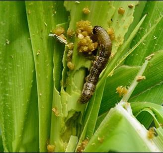
Figure 1: A mature Fall Armyworm caterpillar feeding on maize
Figure 2: Fall Armyworm damage to a maize cob
1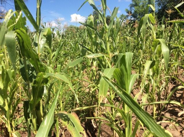
Figure 3: Maize showing leaf damage and leaf colour typical of FAW attack.

Summary
Supported by the World Bank’s Trust Fund for Statistical Capacity Building (TFSCB) ProvEye Ltd
(formerly Orbas Consulting), an Irish company specialising in the application of AI to remote sensing,
and Gorta-Self Help Africa (SHA), an NGO working in Africa, have succeeded in developing a machine
learning algorithm that can detect the damage caused by the Fall Armyworm (Spodoptera frugiperda)
to smallholder maize fields in Southern Africa in satellite images. The Fall Armyworm, the caterpillar
stage of a moth, is a major pest in North and South America which crossed the Atlantic to West Africa
in 2016 and rapidly spread across the continent. The Fall Armyworm feeds on over 80 plant species but
prefers maize, which is the staple food crop for much of East and Southern Africa, causing up to 30%
crop losses. The software can detect the presence or absence of FAW damage with up to 87% accuracy
and the level of FAW damage with 63-75% accuracy, depending on the data available. The success of
this “proof of concept” research provides the foundation for the development of remote sensing software
that can identify FAW damage hot spots at the landscape level, enabling governments to target scarce
control resources on these hotspots. The success also indicates that this approach can be used to detect
other crop pests and diseases that change the colour of the crop canopy.

Problem statement
In August 2016 the Fall Armyworm moth (Spodoptera frugiperda, FAW) crossed the Atlantic to West
Africa and rapidly spread across Africa. The results were dramatic, with maize leaves torn to shreds by
the caterpillars and the cobs destroyed. The damage to maize fields is very distinctive which suggested
the research question: if infested fields can be readily identified by the naked eye can infested fields be
detected from satellite images?

Researchers had successfully identified FAW damage in large homogenous maize fields in North
America from satellite images, but the challenge is to build software that can analyse satellite images
to spot FAW hotspots in small and highly heterogeneous fields in Southern Africa. Machine Learning
algorithms are now widely used in remote sensing so SHA partnered with Dr Jerome O’Connell, AI
remote sensing specialist at ProvEye Ltd, and with the Malawi Ministry of Agriculture and Planet Labs
to test the use of machine learning algorithms to “learn” to spot FAW damaged maize in satellite photos.
ProvEye Ltd had already built machine learning algorithms and image processing tools for remote
sensing to detect land use changes and so were ideal partners for the project.

The ultimate aim is to build software that can rapidly detect FAW hotspots from remote sensing data to
enable Governments, UN agencies, NGOs to focus limited resources on the hotspots. The software may
even be accurate enough to guide precision agriculture equipment used by large scale farmers. This
research, however, was a proof of concept project: could FAW be detected through remote sensing and
which part of the spectrum gives the strongest correlations with FAW damage?

                                                                                                         2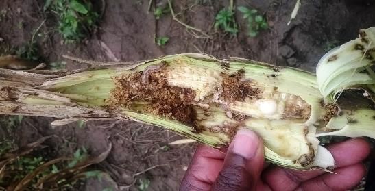
What was involved
The theory behind the approach is to look for correlations between the reflectance of various bands of
the light spectrum of FAW infested fields in satellite images infestations (figures 4 and 5) and the level
of FAW measured by field surveys. Part of the data was used to detect these correlations, which form
the basis of the algorithm. The remaining data is used to test the algorithm: the algorithm is given
satellite images of sites with known levels of FAW damage and asked to calculate the level of damage.
The advantage of a machine learning algorithm is that it learns from its mistakes and the accuracy of
the predictions improves with each cycle. Many factors can affect the reflectance of a maize field: the
maize variety, age of the crop, crop canopy cover, colour of the soil, the height of the crop, nutrient
deficiencies and water stress, so these variables also need to collected and tested.
Figure 4: How plants absorb light
Figure 5: How the colour of a leaf changes when a plant is damaged.
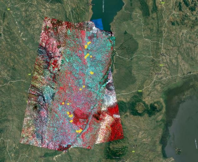
To develop the algorithm the team needed training and testing data from the field. SHA had worked for
several years in Balaka District, Malawi, an area heavily infested with FAW, so maize fields in Balaka
District were selected as sentinel sites (figure 6). Each field was surveyed, and two 15x15 m quadrats
were set up in each field. Teams of surveyors, initially from SHA’s own staff but later from the District
Agriculture Office, conducted three rounds of field surveys per growing season (December to April).
The fields and quadrates were geolocated, first with the iPads used to collect the survey data. This
proved to be too inaccurate, so the sites were resurveyed with hand-held Garmin GNSS, which
improved the accuracy to 2-3m, still a significant error on a 15m x 15m quadrat, and finally with Emlid
Reach RS+ GNSS RTK units with 30cm accuracy. The field team recorded the details of the fields (soil
type, aspect, previous crops, planting date, variety) and then sampled the quadrates. 15 plants were
sampled per quadrat and the level of FAW damage on each plant was assessed on a 0-5 scale.
0: No visible damage and no visible presence of either eggs or caterpillars.
1: No visible damage, eggs present.
2: Shot holes and elongated lesions (>2 cm) on 50% of leaves.
3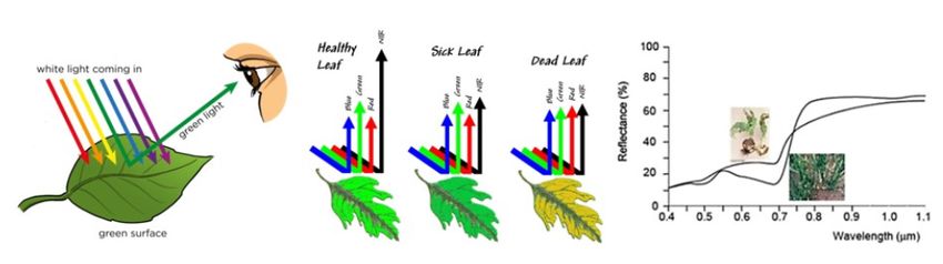
4: Elongated lesions or tattering on most leaves (>75%).
5: Plant dead, dying (dead heart) or economically worthless (cob damage).

A large amount of data was collected from each site to capture all the factors that could affect reflectance
(maize variety, growth stage, soil type, plant population, canopy height, canopy cover, other pests and
diseases, water stress, nutrient deficiencies and nutrient applications) and FAW damage levels (crop
rotations, previous FAW infestations, neighbouring crops).

3.7m resolution, 4 band, satellite images, were sourced from Planet Labs. There was very limited
satellite coverage of the area, which made it challenging to obtain images taken at the time of each
survey round and the small size of the fields (
Machine Learning algorithms learn from their mistakes and after over 1,000 cycles the ProvEye
Random Forest-based algorithm can now detect the presence or absence of FAW damage with up to
87% accuracy. Using the simplified damage scale the level of damage can be predicted with 63-69%
accuracy based on remote sensing data only, however accuracy of 75% can be achieved when field data
is included. The critical field variable is crop growth stage. At the v2-v3 stage there is considerable
reflectance directly from the soil, and from the soil through the leaf, which creates "noise". If the
algorithm knows the crop growth stage it can compensate for this noise.

The first stage of this research used maize fields identified by the survey teams. To be usable by
government agronomists the software needs to be able to detect maize fields in satellite images so the
next stage of the research is to use a “Crop Mask”, a piece of software that can detect the crop
automatically.

The success of the this "proof of concept" research lays the foundations for developing remote sensing
software that can identify FAW damage hot spots at the landscape level, enabling governments to target
scarce control resources on these hotspots and estimate crop losses. The success also indicates that this
approach can be used to detect other crop pests and diseases that change the colour of the crop canopy,
like banana bunchy top virus. It is important to note that this approach only detects crop damage caused
by the FAW and cannot make any predictions about where FAW outbreaks may occur.

National and International networking
The Ministry of Agriculture, Irrigation and Water Development in Malawi fully supported the project,
allocating staff to collect field data, and the project reported to the Malawi National Fall Armyworm
Task Force. The project team in Malawi have close links with the EU, FAO, World Bank and Irish Aid
delegations in Malawi, who have followed the progress of the research with interest and suggested new
applications for the software.

This project, ARMYWORM (Armyworm Research in Malawi Yielding Workable and Original
Remote-Sensing Methods), submitted in response to the 2017 call for proposals by the World Bank’s
Development Data Group (DECDG) and the Global Partnership for Sustainable Development Data
(GPSDD), was supported by the World Bank’s Trust Fund for Statistical Capacity Building (TFSCB)
with financing from the United Kingdom's Department for International Development (DFID), the
Government of Korea, and the Department of Foreign Affairs and Trade of Ireland.

                                                                                                       5
You can also read