Processing of digital images
←
→
Page content transcription
If your browser does not render page correctly, please read the page content below
E3S Web of Conferences 227, 04001 (2021)                                 https://doi.org/10.1051/e3sconf/202122704001
GI 2021

       Present    Software      of                                            photogrammetric
       processing of digital images
       Máté Lehoczky1,2,* and Zoir Abdurakhmonov3
       1
         Pannon Geodézia Ltd, Veszprémi str 7., 8100 Várpalota, Hungary
       2
         iPalota Technology and Science Park, Szent István str. 16, 8100 Várpalota, Hungary
       3
         Tashkent Institute of Irrigation and Agricultural Mechanization Engineers, Kori Niyaziv str., 39,
       Tashkent, Uzbekistan

                     Abstract. Four open source and three commercial software been used to
                     create point clouds from identical data: images taken at five different
                     locations. The investigation compares elapsed time and the size of the
                     generated point clouds for the different software. Based on the tests,
                     suggestions for users are provided.

       1 Introduction
           Nowadays photogrammetry and laser scanning (LiDAR) competes in generating point
       clouds. The present study point clouds generated with photogrammetry is discussed. The
       aim of the study is to provide an overview of the available commercial and open source
       software, and also deliver a comparative analysis on their efficiency based on certain
       aspects. Among the huge number of available software, seven has been selected for the test,
       which are considered to be most widely used ones.

       2 Data and software
           As a first step of a photogrammetric processing sequence, for generating a sparse point
       cloud, most software applies the Structure from Motion (abbreviated as SfM) method [1].
       This algorithm presupposes that the camera is in motion while the object is still. The SfM
       method has primarily been developed for machine vision, though can efficiently be used for
       automatization of photogrammetric processing as well. The steps of the SfM method
       (which is not strictly followed by a software):
           (1) Automatic search of key points (automatically detectable, uniquely marked points)
       on each image, with methods such as SIFT, SURF, or ORB, delivering the position of the
       points (different on each images) and attribute information (independent of size and
       direction, thus independent on the appearance on the different images) [2].
           (2) Relative orientation (optionally absolute orientation as well in case control points are
       available) providing the relative (or absolute) position of the images to each other and the

       *
           Corresponding author: lehomate@gmail.com

© The Authors, published by EDP Sciences. This is an open access article distributed under the terms of the Creative Commons
Attribution License 4.0 (http://creativecommons.org/licenses/by/4.0/).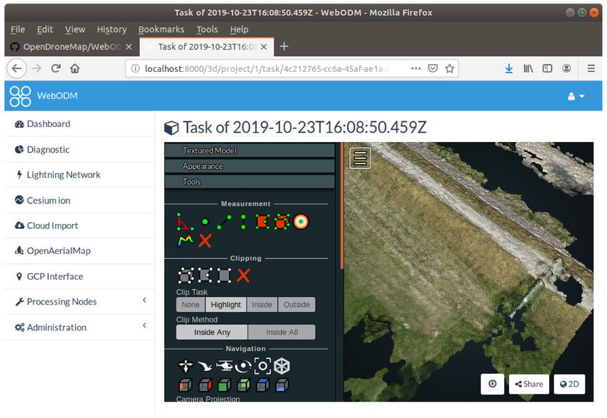
E3S Web of Conferences 227, 04001 (2021) https://doi.org/10.1051/e3sconf/202122704001
GI 2021
coordinates of the reference points (a subset of key points, which can successfully be
determined by the orientation).
The resulted point set is the so-called sparse point cloud, the outcome of the SfM. A
sparse point cloud may visualize appropriately the texture, geometrical content is rough
(e.g. edges). Even though the SfM derives a 3D model, it does not generate new corners or
edges, but applies the edges of the texture [3].
After the SfM, the dense point cloud is generated. Most of the software use telemetry data
or the absolute oriented point cloud to generate derived products, such as orthophoto,
Digital Terrain Model (DTM) or Digital Surface Model (DSM) [4]. The source of the
images can be hand-held camera or cell phone, UAV-borne camera, but also pictures
available on social media (e.g. Flicker, Mapillary) can be used (c.f. Fig 1). Mapillary is a
project dedicated to data acquisition from social media, which resembles to Google Street
View, though Mapillary contains images of front-facing cameras only. The data is collected
volunteers mostly with cell phones mounted to the windscreen of cars. The processing
software may also make use of the EXIF (Exchangeable Image file Format) content of
JPEG files, such as telemetry data, focal length, etc. Generally, 80% or more overlap of the
images is expected.
Fig. 1. Ways of data acquisition: terrestrial, UAV-borne, Mapillary.[5]
Several software is based on open source base directories (commercial also), such as
OpenCV (Computer Vision) and OpenMVG (Multiple View Geometry). The OpenCV is a
C++ program library, which includes methods for search of key points, referencing images,
and can solve processing up to the generation of the sparse point cloud. The functions of the
OpenCV library can be accessed also by using Python. OpenMVG can be used for
generating the dense point cloud from the oriented images.
For most of the software, the steps of the processing is quite similar. (Steps in
parentheses are sometimes skipped, usually these are required only for absolute orienting /
georeferencing).
1. Start a project
2. Add images to the project
3. (Input the coordinates of control points)
4. Automatized search for key points
5. Triangulation: generation of the sparse point cloud
6. (Mark control points on images)
7. Generation of the dense point cloud
8. (Generation of derived products, e.g. orthophoto, mesh model, DTM, DSM)
In case of an automatized processing sequence, all data input (images, control points)
should be entered as a first step, then the processing is done completely automatically.
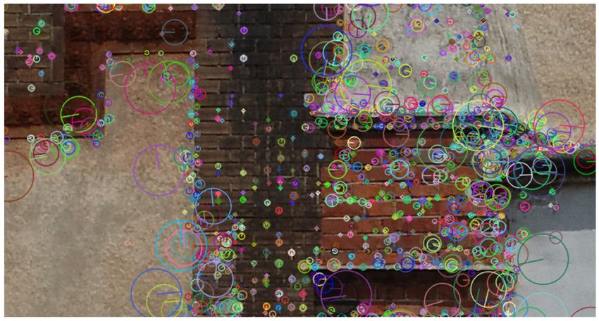
Fig 2 shows detected key points by one of the tested software. It can be seen clearly that
no adequate points were identified on the homogeneous surfaces (see the bottom-left and
top-right corners of the figure). The size of the coloured circles displays the accuracy
estimated while the marked radius displays the estimated direction of the key point on
another image. Each image may contain ten thousands of key points.
2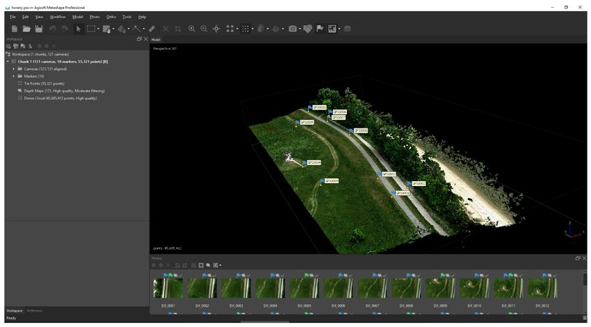
E3S Web of Conferences 227, 04001 (2021)                              https://doi.org/10.1051/e3sconf/202122704001
GI 2021

      Fig. 2. Identified key points, with the accuracy (size of the circle) and the direction of the point on
      another image (marked radius of the circle) is displayed. [5]
          There are expectations on the Hardware capacities for most of the software, such as
      number of processors (CPU) and nodes; often 6-8 nodes may be demanded. The different
      steps of the photogrammetric processing sequence mean different workload for the
      processors as well. The computation time of some steps depends only on the clock speed,
      while others can make use of the multiple nodes. For example, generating a dense cloud is
      efficient with multiple nodes, while building a texture or a mesh model needs generally
      high clock speed but less nodes. Also, the processing power of the graphics card (GPU)
      may also be involved in the processing, for example the computation time of densification
      of the point cloud depends notably on the number (and the type) of GPUs. Since this step is
      the most time consuming, it is important select all the available GPUs to be used for
      processing. Approximately, a graphics card with an additional GPU can reduce the
      computational time by 20-25%, which with one more GPU can be further reduced by
      ~10%. Additional GPUs, however, won't affect the computation time relevantly (1-3%
      only), so it does not verify the additional costs.
          In case of hundreds or thousands images are processed, the memory (RAM) capacity
      should be maximized (at least 64GB is needed). The memory demand depends on the
      number of images, and the demanded resolution. As the use of RAM is approximately
      linear, by a test run for a subset of data, the computation time can properly be estimated.
      Normally, generating the dense point cloud and the mesh model is the most RAM-
      consuming. For processing aerial images, in case of some software there are special settings
      for the nadir images, which enables more efficient processing. In case of oblique images,
      however, the demand on high memory capacity is unavoidable.
          Furthermore, data storage is also a relevant issue. As primary drive, SSD is suggested to
      be used, which contains both the operational system and the processing software. High
      speed SSD enables fast loading and handling of the data.
          All in all, for professional photogrammetric processing the optimal computer can be
      defined somewhere between the Gamer PCs and laptops. For smaller tasks and study,
      middle range PCs can also be sufficient. Finally, the option of online processing should also
      be mentioned, as cloud computing is more often supported by photogrammetric software.

                                                          3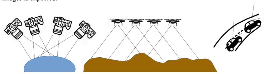
E3S Web of Conferences 227, 04001 (2021)                      https://doi.org/10.1051/e3sconf/202122704001
GI 2021

         Within the frame of the present analysis, 4 open source (VisualSfM, Regard3D,
      COLMAP, ODM/WebODM) and 3 commercial (3DSurvey, Agisoft Metashape, Recap
      Photo) software are compared.

      3 Used software
          For the tests, altogether 7 software has been used [6]. In the following section these are
      introduced, and their main parameters are summarized in Table 1.

      3.1 Open source software
          Due to the OpenCV and OpenMVG libraries, new photogrammetric processing
      software can easily and efficiently be developed. As a result, several such projects have
      been started from 2010, although in many cases further updating and developments are
      ceased. For the present study, open source software with stable background (with frequent
      updates, and relevant user and developer community) are considered. Note, however, that
      open source software may have a limited applicability, thus it is always to check carefully
      the software's licence before use.

      3.1.1 VisualSfM
          One of the earliest open source photogrammetric processing software, which applies
      SfM and MVG algorithms. The development has been started in 2011, and no new version
      has been published in the last two years. It has a special licence, indicating that it can only
      be used for private and research use [7].
          For determining the key points, it requires ATI/nVidia/Intel GPU with at least 1 GB
      memory. For the 3D reconstruction nVidia CUDA or the CPU can also be used. For
      generating the dense point cloud PMVS/CMVS patch is used. No derived products (e.g.
      orthophoto) can be generated. Both graphical and command-line interface can be used.
          Though the program can efficiently process the images, also the user interface can
      easliy be acquired, drawbacks are that the updates have been ceased, and also that
      commercial use is not supported.

      3.1.2 Regards3D
          It has been started to be developed in 2015. Very user friendly, it guides the user with
      clear instructions through the processing steps in an interactive manner, enabling setting for
      different algorithms and parameterization in dialog boxes. Within one processing sequence,
      plenty of variants of processing can be run in parallel. No special requirements for the
      hardware is defined, however, it cannot process more than some hundred images at once. It
      uses MIT-licence, which enables wide range of use, including its use within a commercial
      software as well.
          No reference points can be involved into the processing; accordingly, only relative point
      cloud can be generated. In order to transform to an absolute coordinate system, some other
      software (e.g. CloudCompare) should be used. The software is frequently used in cultural
      heritage management for modelling buildings and sculptures [8]. It is a good starting point
      for beginners to get acquainted with this technology.

                                                    4
E3S Web of Conferences 227, 04001 (2021) https://doi.org/10.1051/e3sconf/202122704001
GI 2021
3.1.3 COLMAP
The COLMAP software has been started as a PhD research, it's first licence has been
published in 2016 as a BSD-license. The main purpose of the software was pure research,
development, and test of algorithms. As a result, the program has a very wide range of
options for parameterization, which may be a difficulty for unexperienced users. It is rather
for research purposes for experimenter users.
Large (more than 10000 images) can also be processed, although the computational
time is not optimal. It can used with graphical and command-line user interfaces as well.
The present version cannot be used for generating orthophoto. Even though the software is
mainly developed by one person, dozens of developers contribute to his work.
3.1.4 OpenDroneMap (ODM) and WebODM
Among the open source software, ODM is prominent with its dynamics in development
(started in 2016) and various services. The software is published under the GPL3-license.
The ODM can only be used from command-line, which might be a difficulty for a regular
user of present days. It is supported by the WebODM, which allows the use of ODM from a
web browser with a graphical interface. With the use of the webODM, also cloud
computing can be used.
Originally ODM has been developed for processing UAV-borne images. Although a
plenty of parameters can be set, for beginner users also a default setting is suggested for
each parameter. WebODM is not only a processing tool, it can also display nicely the
results of the computations (c.f. Fig 3). Beyond the dense point cloud, the mesh model and
the orthophoto, DTM and DSM can also be generated. It is recommended to be run under
the Docker container of the Linux operation system. Note that the instalment is rather
complex.
Fig. 3. Coloured point cloud in WebODM.
5E3S Web of Conferences 227, 04001 (2021) https://doi.org/10.1051/e3sconf/202122704001
GI 2021
3.2 Commercial software
3.2.1 3D Survey
The 3D Survey has been started to be developed back in 2011 by a Sloven group of
(mainly) surveyors. The software has been first published in 2014, since then its popularity
is raising year by year. The company consists of 11 persons, among them 3-5 are purely
working on the development. Its success is based on the user-centric and dynamic
development policy and adaptive support service. Quite a few setting and parameterization
option can be set by the user, which is both an advantage and a disadvantage. Nevertheless,
it is an optimal choice for a beginner user.
There are a number of constantly evolving modules, such as more and more refined
CAD-functions, point cloud classification, volume calculation, automatic profile- and cross
section generation. A unique service of the software is the automatic reference point
recognition, for which special, round-shaped markings are provided by the company. The
recognition, which is based on machine vision, can notably reduce the manual workload.
Fig. 4. Dense point cloud in Agisoft Metashape.
3.2.2 Agisoft Metashape
One of the most commonly used photogrammetric processing software, originated from
Russia started to be developed in 2006, first published in 2010 under the name Agisoft
Photoscan. A huge range of options for parameterization and settings, which also results in
an increased number of source of errors. In case a limited capacity hardware is available, it
can be used by distributing the task into smaller units, so-called chunks: the processing can
be done separately for each chunk, and their outcome can be merged into one. A special
feature is that task lists can be defined for a certain processing sequence, yielding an
automatization of the processing. Different, sometimes quite special camera calibration data
can also be involved in the processing, e.g. shutter compensation. Multispectral images can
also be processed by assigning for each channels a colour. This software has one of the best
point cloud classification method (Fig 4).
6E3S Web of Conferences 227, 04001 (2021) https://doi.org/10.1051/e3sconf/202122704001
GI 2021
3.2.3 ReCap Photo
A product of Autodesk, which has been appeared as ReCap Photo in 2016, which is a
cloud computing service making use of earlier photogrammetric products such as ReMake
and 123D. There are nearly no options for parameterization, with limitations on the size of
a project: minimum 20, maximum 1000 images can be uploaded. Before uploading, one can
choose between to options. In the first option, no map projection system and reference
points can be included; this option can be used for object (e.g. building) modelling,
appropriate for cultural heritage management. The other option can be used for processing
nadir images, where a map projection system can be selected, output data can be defined
(point cloud, texture mesh and orthophoto), and also reference points can be defined. The
results of the calculations can be stored on an Autodesk cloud storage.
Table 1. Software data sheet. Abbr.: T - terrestrial, A - aereal, CLI - command-line interface, GUI -
graphical interface, Pc - point cloud, Mm - mesh model, Tx - texture, Op - orthophoto, DSM - Digital
Surface Model
Software Op. system Value A/T Interface Licence Output
VisualSfM Lin, Win, + T, (A) CLI, GUI open** Pc
0.5.26 OSX
Regard3D Lin, Win + T, (A) GUI Open MTI Pc, Mm
1.0
COLMAP Lin, Win, ++ T, A CLI, GUI Open BSD Pc, Tx, Mm
OSX
ODM, Lin, Docker ++ A CLI, web Open GPL Pc, Tx, Op, Mm,
WebODM DSM
3D Survey Win ++ A, T GUI Commercial Pc, Tx, Op, DSM
Agisoft Lin, Win, +++ A, T GUI Commercial Pc, Tx, Mm, Op,
Metashape OSX DSM
ReCap Photo Win+cloud ++ A, T GUI Commercial Pc, Tx, Mm, Op,
DSM
4 Tests and results
Altogether 5 worksites have been used for testing. For the tests, relatively small
worksites were used as the performance of the available hardware was limited. The
observations were acquired using 3 different UAVs: DJI Phantom 4, DJI Phantom 4P,
UAV Birdie Geo+. The test sites and the information on the measurements is summarized
in Table 2.
Table 2. Data of the test acquisitions
settlement setting No. of images UAV Notes
Horány rural 12 DJI Phantom 4
Öskü urban 42 DJI Phantom 4P oblique, taken from a tower
Siófok urban 116 DJI Phantom 4P taken in a rectangular grid
Horány rural 121 DJI Phantom 4
Várpalota urban 160 UAV Birdie Geo+
7E3S Web of Conferences 227, 04001 (2021) https://doi.org/10.1051/e3sconf/202122704001
GI 2021
The following hardware have been used:
- N1: i7 core 6, 4,5 GHz, 64 GB RAM NVIDIA GeForce GTX 1080, Windows 10
– N2: i7 core 6, 3,5 GHz, 32 GB RAM, NVIDIA GeForce GTX 1050 Ti, Windows 10
– N3: i5 core 4, 2,3 GHz, 8 GB RAM, NVIDIA GeForce GT 525M, Ubuntu 18.04
The processing with the ODM and WebODM software has been performed on a LinuX
operation system (N3), while the Agisoft Metashape licence was available only for the N1
computer.
For each test runs, the computational time in minutes (ct) and the size of the point cloud
in million-points (mp) have been recorded. The results are summarized in Table 3 and 4.
Table 3. Results of the test run for the open source software. ct: computational time in minutes, mp:
size of the point cloud in million-points
settl. No. fac Regard3D VisualSfm COLMAP 3Dsurvey
im. ct mp ct mp ct mp ct mp
Horány 12 N2 12 0.9 4 0.5 16 2.8 6 1.2
N3
Öskü 42 N2 157 2.0 10 1.0 94 4.7
N1 8 7.0
Siófok 116 N3
N2 101 2.8 72 1.7 170 2.3 108 9.5
N1 89 2.8 67 99 8.7
Horány 121 N3
N2 94 3.5 51 1.9 74 4.7 52 3.7
N1
Várpalota 160 N2 91 11.5
N1 120 17.9 120 35.7
Table 4. Results of the test run for the commercial software. ct: computational time in minutes, mp:
size of the point cloud in million-points
settl. No. fac Agisoft RC WebODM
im. ct mp ct mp ct
Horány 12 N2
N3 9 0.8
Öskü 42 N2
N1 5 21.7 2.0
Siófok 116 N3 119 3.6
N2
N1 93 59.4 5.0
Horány 121 N3 124 10.6
N2
N1 38 45.7
Várpalota 160 N2
N1 60 140.2 3.0
5 Discussion and summary
According to the results (c.f. Table 3 and 4), open source software cannot compete with
commercial ones in performance, capacity, and complexity. Note, however that the
development of open source software is much dynamic than that of commercial ones as
these developments are usually focusing on certain steps of the workflow.
An advantage of open source software is that nearly for any platform and operating
system apt software can be found. Also, an advantage is that they allow a huge freedom in
parameterization, supporting research activity. Due to the accessible code, the processing
8E3S Web of Conferences 227, 04001 (2021) https://doi.org/10.1051/e3sconf/202122704001
GI 2021
manner can be adjusted to a certain task, resulting in a more efficient workflow.
Nevertheless, this requires a high-level background in informatics, in general. Among the
tested open source software, ODM (with its alternate, WebODM) turned to be the most
perspective.
Commercial software are in most cases optimized for Windows (possibly for IOS).
Their use is definitely user friendly, and their operation is quite stable. Meanwhile less
room for parameterization is enabled. Furthermore, as they work as a "black box", i.e.
information on the computational method is hidden, there is very limited possibility for
check / verification of the results. By time, commercial software tends to create more and
more complex user interface in order to fulfil all demands and deliver a tool for wide range
of applications.
According to the tests, Agisoft Metashape was found to be the most efficient providing
the largest point density with the shortest computational time. Still, other software also have
their speciality, in which they prove to be the best. The support, the customization of the
orthophoto, and the volume calculation is outstanding for 3D Survey. ReCap Photo can
create the most plastic / statuesque models; its high-level texture is a consequence of the
advancement of Autodesk software, in general.
All in all, open source software have relevant potential in development, they provide a
proper playground for testing unique ideas and demands. In contrary, they require a more
creative and advanced user. Open source software are recommended for learning and
research activity. Commercial software are better (at the time of the present investigation),
due to their structural and financial background. Users can use these software with very few
background in surveying or informatics, although they have very few options to change the
settings of parameterization. For commercial use, in order to ensure productivity, the use of
these software is still recommended over open source software.
References
1. J. L. Schönberg, J. Frahm, 2016 IEEE Conference on Computer Vision and Pattern
Recognition (CVPR), Las Vegas, NV, 4104-4113. DOI: 10.1109/CVPR.2016.445
(2016)
2. D. G. Lowe, International Journal of Computer Vision, 60, 91–110. DOI:
10.1023/B:VISI.0000029664.99615.94 (2004)
3. S. Bianco, G. Ciocca, D. Marelli, J. Imaging, 4, 98. DOI: 10.3390/jimaging4080098
(2018)
4. F. Remondino, M. G. Spera, E. Nocerino, F. Menna, F. Nex, Photogrammetric record,
29, 146, 144-166. DOI: 10.1111/phor.12063 (2014)
5. M. Lehoczky, Z. Siki , Geodezia es Kartografia 2020/2, 23-27. DOI :
10.30921/GK.72.2020.2.4 (2020)
6. G. Vacca, Int. Arch. Photogramm. Remote Sens. Spatial Inf. Sci., XLII-4/W14, 239–
245. DOI: 10.5194/isprs-archives-XLII-4-W14-239-2019 (2019)
7. C. Wu, link: http://ccwu.me/vsfm/ ; last retrived: 20 September, 2020 (2020)
8. H. Rahaman, E. Champion, Heritage, 2, 1835-1851. DOI: 10.3390/heritage2030112
(2019)
9You can also read