PROFECY - Processes, Features and Cycles of Inner Peripheries in Europe
←
→
Page content transcription
If your browser does not render page correctly, please read the page content below
PROFECY – Processes,
Features and Cycles of Inner
   Peripheries in Europe
  (Inner Peripheries: National territories facing
challenges of access to basic services of general
                    interest)

               Applied Research

                 Final Report

             Annex 17
          Brief Overview
   of 10 IP Regions in Europe
              Version 07/12/2017
This applied research activity is conducted within the framework of the ESPON 2020 Cooperation
Programme, partly financed by the European Regional Development Fund.

The ESPON EGTC is the Single Beneficiary of the ESPON 2020 Cooperation Programme. The
Single Operation within the programme is implemented by the ESPON EGTC and co-financed by
the European Regional Development Fund, the EU Member States and the Partner States,
Iceland, Liechtenstein, Norway and Switzerland.

This delivery does not necessarily reflect the opinion of the members of the ESPON 2020
Monitoring Committee.

Authors
Paulina Tobiasz-Lis, Karolina Dmochowska-Dudek, Marcin Wójcik, University of Lodz, (Poland)
Mar Ortega-Reig, Hèctor del Alcàzar, Joan Noguera, Institute for Local Development, University of
Valencia (Spain)
Andrew Copus, Anna Berlina, Nordregio (Sweden)
Francesco Mantino, Barbara Forcina, Council for Agricultural Research and Economics (Italy)
Sabine Weck, Sabine Beißwenger, Nils Hans, ILS Dortmund (Germany)
Gergely Tagai, Bálint Koós, Katalin Kovács, Annamária Uzzoli, Hungarian Academy of Sciences,
Centre for Economic and Regional Studies (Hungary)
Thomas Dax, Ingrid Machold, Federal Institute for Less Favoured and Mountainous Areas (BABF)
(Austria)

Advisory Group
Project Support Team: Barbara Acreman and Zaira Piazza (Italy), Eedi Sepp (Estonia), Zsolt
Szokolai, European Commission.
ESPON EGTC: Marjan van Herwijnen (Project Expert), Laurent Frideres (HoU E&O), Ilona
Raugze (Director), Piera Petruzzi (Outreach), Johannes Kiersch (Financial Expert).

Information on ESPON and its projects can be found on www.espon.eu.

The web site provides the possibility to download and examine the most recent documents
produced by finalised and ongoing ESPON projects.

This delivery exists only in an electronic version.

© ESPON, 2017

Printing, reproduction or quotation is authorised provided the source is acknowledged and a copy
is forwarded to the ESPON EGTC in Luxembourg.

Contact: info@espon.eu

PROFECY – Processes, Features
and Cycles of Inner Peripheries in
            Europe
Table of contents
List of Maps ................................................................................................................................ ii
List of Tables .............................................................................................................................. ii
1 Introduction ........................................................................................................................ 1
2 Brief profiles of 10 IP regions in Europe............................................................................ 2
2.1 Delineation results and location in the European space ........................................... 2
2.2 Overview of the selected regions .............................................................................. 4
2.2.1 Wilthshire and Swindon, United Kingdom........................................................ 4
2.2.2 Kainuu, Finland ................................................................................................ 6
2.2.3 Keesk-Esti, Estonia .......................................................................................... 8
2.2.4 Hautes-Alps, France ...................................................................................... 10
2.2.5 Douro, Portugal .............................................................................................. 12
2.2.6 Tulcea, Romania ............................................................................................ 14
2.2.7 Evrytania, Greece .......................................................................................... 16
2.2.8 Flevoland, Netherlands .................................................................................. 18
2.2.9 Virovitičko-podravska županija, Croatia......................................................... 20
2.2.10 Kanton Wallis, Switzerland........................................................................ 22
References .............................................................................................................................. 24
ESPON 2020 iList of Maps Map 2.1: Location of IP regions and chosen case studies in European space......................... 3 List of Tables Table 2.1: Results of final delineation for 10 selected IP regions in Europe ............................. 2 ESPON 2020 ii
Abbreviations:

D1           Delineation 1 Access to regional centres by car
D2           Delineation 2 Economic Potential Interstitial Areas
D3           Delineation 3 Areas of Poor Access to SGIs
D4           Delineation 4 Inner peripheries according to their demographic situation
DG AGRI      Directorate-General for Agriculture and Rural Development
DG REGIO     Directorate-General for Regional and Urban Policy
EFRO         Europees Fonds voor Regionale Ontwikkeling
ESPON        European Territorial Observatory Network
ESPON EGT    ESPON European Grouping on Territorial Cooperation
EU           European Union
FEDER        Fonds Européen de Développement Économique et Régional
GDP          Gross Domestic Product
ICT          Information and Communication Technology
IPs          Inner Peripheries
LEADER       Liaison Entre Actions de Développement de l'Économique Rurale
LEPs         Local Enterprise Partnerships
MRA          Metropolitan Region of Amsterdam
NGOs         Non-Governmental Organizations
NUTS         Nomenclature of Territorial Units for Statistics
PROFECY      Processes, Features and Cycles of Inner Peripheries in Europe
R&D          Research & Development
SGIs         Services of General Interest
SME          Small and medium-sized enterprises
UNESCO       United Nations Educational, Scientific and Cultural Organization

ESPON 2020                                                                              iii
1 Introduction
This Annex presents brief profiles of ten IP regions in Europe, outside those seven countries
where case study areas conducted within the project are located. They were selected on the
basis of an initial procedure described in details in the Annex 9 and following final IP
delineation results obtained in the project summarized in tables and presented on the map of
Europe. Due to the character of this task and the level of delineation data (NUTS-3), selection
process was conducted on NUTS-3 regions.

The brief, one-page presentation of all ten selected regions, as requested by the ESPON
EGTC is based on research knowledge and experiences of all Consortium partners, gained
during the project and consists of four parts:

    1) the general information – on geographical and administrative location of selected
        areas, their physical and socio-economic character

    2) main problems and challenges – with the strong focus on the results of IP
        delineations carried within the project, what they mean for the region, how are they
        reflected in its socio-economic and spatial performance

    3) strengths and the growth strategy – presenting opportunities and positive changes,
        both planned and already implemented according to coping strategies undertaken by
        national/regional/local authorities to reverse problems of the area

    4) Future development – stressing the main ideas coming from the strategic planning
        documents addressing the areas of interest.

ESPON 2020                                                                                   1
2 Brief profiles of 10 IP regions in Europe
2.1 Delineation results and location in the European space
Final results of four IP delineations, defined and explained throughout the PROFECY Project,
which have been used to verify selection process of seven case study regions as presented in
the Annex 9, have also been the basis to select ten additional regions in the European space,
as requested by the ESPON EGTC. Four different delineation approaches have been
identified in the PROFECY project, each of which looks at inner peripheries from different
perspectives:
- Delineation 1 (D1): Higher travel time to regional centres;
- Delineation 2 (D2): Economic potential interstitial areas;
- Delineation 3 (D3): Areas of poor access to SGI;
- Delineation 4 (D4): Depleting areas.
The team responsible for this task made an effort to find areas representing different parts of
Europe as well as different types of IPs according to the effect of combining results of all four
delineations listed above.
Table 2.1 shows results of combining four IP delineations in selected areas, indicating their
characteristics. Ten selected regions represent seven different combinations of all sixteen
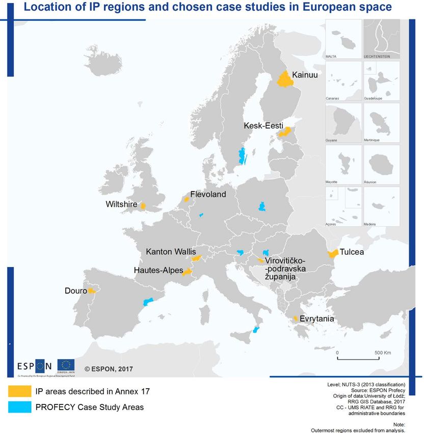
described in the PROFECY project in the Annex 4. Map 2.1 presents their geographical
location in Europe beside the location of NUTS-3 inside of which case study regions, initially
selected and examined within the PROFECY project.
Table 2.1: Results of final delineation for 10 selected IP regions in Europe
Country NUTS NUTS D1* D2* D3* D4* Combination results
CODE LABEL
United UKK15 Wiltshire CC 1 1 1 1 absolute remote and
Kingdom UKK14 Swindon depleting
Finland FI1D4 Kainuu 1 0 1 1 low access to centres and
services, depleting, but still
good/stable economic
potential
Estonia EE006 Kesk-Eesti 0 0 0 1 high accessibility and
economic potential, but still
depleting
France FR822 Hautes- 1 0 1 1 low access to centres and
Alpes services, depleting, but still
good/stable economic
potential
Portugal PT11D Douro 1 1 0 0 low access to centres and
low potentials, but still
good/stable access to SGIs
and thus not yet depleting
Romania RO225 Tulcea 0 1 1 1 Although good access to
centre, poor economic
potential, overall poor
access to SGIs and thus
depleting
Greece EL643 Evrytania 1 0 1 1 low access to centres and
services, depleting, but still
good/stable economic
potential
ESPON 2020 2Netherlands NL230 Flevoland 1 0 1 1 low access to centres and
services, depleting, but still
good/stable economic
potential
Croatia 1 0 0 1 Poor access to a centre and
Virovitičko- depleting, but still economic
podravska potentials and good access
HR048 županija to SGIs
Switzerland CH012 Kanton 1 0 1 0 Low access to centres and
Wallis services, but still good
economic potentials and not
yet depleting
Map 2.1: Location of IP regions and chosen case studies in European space
ESPON 2020 32.2 Overview of the selected regions 2.2.1 Wilthshire and Swindon, United Kingdom Background Witthshire (UKK15) is a county in South West England with an area of 3,485 sq. km and total population of 706,300 (2016). It is landlocked and borders the counties of Dorset, Somerset, Hampshire, Gloucestershire, Oxfordshire and Berkshire. Swindon Borough (UKK14), located on the North East of the Wiltshire County is a unitary authority, independent of Wiltshire Council. Swindon, with the population of approx. 217 000 (2016) is also the most important city of the whole area. The next largest towns in Wiltshire are Salisbury, Chippenham and Trowbridge with between 30,000 and 42,000 residents each. In the settlement network of the county predominant are small towns and villages sometimes becoming isolated pockets of access deprivation as their distance and travel time to cities and bigger towns is too long. The Wiltshire economy is largely based on the service sector and farming, with a significant armed forces presence in the very central part of the region, but little primary or secondary industry. In the northern part of the region, runs the M4 motorway connecting London and South Wales (Cardiff, Swansea) in the United Kingdom. Especially Swindon, located by the motorway benefits from this important road. Many national and international corporations such as: Honda, Intel, Motorola, Patheon, Catalent (formerly known as Cardinal Health), Becton-Dickinson, WHSmith are located there. Being a strong development factor for the northern part of the region, the limited sphere of influence of the M4 motorway causes high disproportions with the socio-economic situation of its central and the southern parts. Challenges and Problems According to calculations by the PROFECY project, the county of Withshire performs as IP regarding all four delineations: relative low access to regional centres, and services of general interest, low socio-economic potential. Areas where all IP delineations are valid, considered as absolutely remote and depleting cover only 0.3% of Europe. However, as IP delineations were analysed on the NUTS-3 level, it has to be stressed that not the whole county of Wiltshire is that problematic. The main challenge of this region is the scale of its internal socio-economic disparities that highly affect residents’ well-being. People living in rural areas of Wiltshire make up approximately half the total population, whilst in Swindon, only 10.5% of the population is rural. According to the 2011 census data, significant areas of Wiltshire were in the 5% most deprived in England. In urban areas, four wards in Swindon experienced very high levels of deprivation and there were two areas in the Wiltshire Local Authority that were in the 5% most deprived: Trowbridge Adcroft and Salisbury Bemerton. The worst child poverty was in Swindon where about 45% of children lived in poverty. Housing, especially in Wiltshire, where average house cost approximately 8.6 times the average wage of low-income people, was unaffordable for many. The cost of living in rural areas was significantly higher than in urban areas. Housing was less affordable and services are harder to access. The distance to the nearest shop was often much further and the cost of ESPON 2020 4
basic services often higher. The main routes across Wiltshire are the M4, A350 and A36.
Journeys across the county from East to West or vice versa are straightforward. Journeys
North to South and vice versa are reasonable in the West of the county. Any other journey is
long and difficult. There are two rail lines to London from Chippenham and Swindon and from
Salisbury. To reach other stations in Wiltshire, a change in Bath is often required. Reliance on
the private car and lorry has resulted in busier more congested roads, reducing air quality,
especially in towns that do not have bypasses.
Among the main challenges for the future economic development of the Wiltshire County
underlined in the Strategic Economic Plan for Swindon and Wiltshire, there are: 1) declining
competitiveness; 2) the impact of the economic recession, 3) low rates of higher education
participation in Swindon; low rates of new business openings, 4) inadequate transport
infrastructure to support expansion plans.

Strengths and Growth Strategy
The UK Government’s drive to build a knowledge-based economy for future prosperity has
led to significant investment in Local Enterprise Partnerships (LEPs) between local authorities
and business. Swindon and Wilthshire took advantage of the second round of Growth Deals
announced on 29th January 2015. Growth Deals provide funds to local enterprise partnerships
(LEPs) for projects that benefit the local area and economy. The Swindon and Wiltshire
Growth Deal enable major new housing, support the local innovation economy, promote the
growth of skills and businesses, and improve transport connectivity in the Local Enterprise
Partnership’s three priority growth zones: Swindon-M4 Growth Zone, the A350 Growth Zone
and the Salisbury-A303 Growth Zone. Against the 378 districts nationally, Swindon ranks 46
performing in the top 20%, whilst Wiltshire is ranked 155 for knowledge based economic
performance.

Future Developments
Priorities and future opportunities for the development of the region by 2026 are reflected in
the 2016 Swindon and Wiltshire Strategic Economic Plan focused on general objectives and
Growth Zones originally identified in 2014.

ESPON 2020                                                                                    5
2.2.2    Kainuu, Finland
Background
Kainuu (FI11D4) is the region in north-eastern Finland, historical province of Ostrobothnia of
the total area of 22 687 sq. km and 75 415 inhabitants (2016). Kainuu borders the regions of
Northern Ostrobothnia, North Karelia and Northern Savonia. In the east, it also borders
Russia. The area is classified as Predominantly Rural according to the European Commission
(DG REGIO and DG AGRI). It consists of eight sub-regions (municipalities) with the dominant
role of Kajaani (due to administrative capital in the city of Kajaani which leads to the stronger
economic activity and the concentration of almost half of the region’s regions population – 37
664 inhabitants) Sotkamo (10 524 people), Kuhmo (8 820 people) Suomussalmi (8 342
people) and four smaller of Paltamo (3 493), Puolanka (2 784), Hyrynsalmi (2 432) and
Ristijärvi (1 356).

The largest sector in the employment market of Kainuu is the service sector with about 74%
share of the regions entire employed workforce. The industrial and construction sector follow
as the second largest actor with about 18% of the employed working under these fields. Third
largest sector is the forest industry and agriculture with about 8% workforce.

Challenges and problems
According to calculations by the PROFECY project, Kainuu region performs as IP regarding
three out of four implemented delineations and their combination has been described as the
example of the area of low access to centres and services, depleting, but with still good/stable
economic potential. However, as the region is of a large area, in its different parts, different
drivers of inner peripherialization process tend to play a predominant role – in the
easternmost parts of the Kajnuu region it is a low access to regional centres and SGIs and
the closer to the west, the more important is the driver of poor economic/demographic
potential. In the case of Kainuu, especially the latter one (demographic depletion) seems to
be the most problematic.

The population in the Kainuu region is diminishing. According to the Statistics Finland and the
Population Registration Centre (2015) in 35 years - between the 1980 and 2015 the number
of the region’s inhabitants decreased from 99 250 to 79 000 (by almost 20%), mainly due to
the massive out-migration process especially of young, working age people. In 2015, the net
migration rate for the Kainuu region was -11.9, compared to 0.6 for the whole Finland. As the
consequence, the population is ageing – old dependency rate increased from 36.1% in 2013
to 40% in 2015 when the country’s average was 31.3%. One notable reason for these
processes is that there is no permanent university education available in the region 1 (p.14).

Unemployment rate of about 11%, compared to average 8% in Finland is quite stable in the
last few years but it mainly affects young people being another reason for them to move out of
the region1 (p. 18).

ESPON 2020                                                                                       6
Low economic potential of the region is reflected in the GDP per capita which is about 80% as
compared to the European Union (EU28=100) and Finland being overall above EU’s average
(109% in 2015).

Strength and Growth Strategy, future developments
A significant factor in the regional economics of Kainuu is tourism. The two most important
seasons for the regions tourism are winter and summer. Apart from sport resorts located in
Paljakka, Ukkohall and Vuokatti, offering various sport possibilities for different seasons such
as skiing, downhill skiing and hiking among others, tourism related service clusters and
networks develop. Around the biggest lake in the region: Oulujärvi services in water- and
culture based tourism concentrate and develop well.
Among key strategies and documents driving the actions of Regional Council of Kainuu are:
(1) The Regional Plan of Kainuu, presenting long-term vision for the region and the politically
desired outcomes for the future with the corresponding: (2) The Regional land use plan, (3)
Regional Programmes of the time frame of 4 years, which intent to bring up ways and means
through which the long timespan strategic goals of the Regional Plan can be accomplished
and (4) Implementation Plans with the time frame of two years aimed at monitoring,
prioritizing and harmonizing the region councils work together with other authorities that relate
to the goals set in the regional programme. The implementation plan is an instrument to
guiding projects in a way that the themes and goals of the regional programmes and the
condition for the fund funding are met and achieved in these projects

ESPON 2020                                                                                     7
2.2.3   Keesk-Esti, Estonia
Background
Kesk-Eesti (EE006) is a group of three counties (Järva, Lääne-Viru and Rapla) located in
central Estonia with a total area of 9,067 km2 and a total population of 126,372 people
(2014). Järva and Rapla counties are landlocked while Lääne-Viru is located on the coast.
Paide is the regional centre of Järva County and is located 93 km from Tallinn. Järva County’s
economy is dominated by the SMEs in the field of timber, metal and food industry and
building materials. Rakvere is the regional centre of Lääne-Viru County and is located 99 km
from Tallinn. Lääne-Viru is an industrialized county with strong export industries. It has
deposits of oil shale, phosphorous and technological limestone. Rapla is the regional centre
of Rapla County and is located 53 km from Tallinn. The primary sector accounts for 14.7% of
the regional GDP in Rapla county that is almost ten per cent higher than the national average
(2012). There are no significant mineral resources in the county and no large industries.

Challenges and Problems
According to calculations by the PROFECY-project Kesk-Eesti region performs as IP
regarding the delineation 4: socio-economic performance. This can be explained by a strong
influence of the capital region which is a centre of attraction for businesses, investors and the
population. It should be also stressed that it is the only NUTS-3 region of Estonia where
neither any of the largest urban areas nor important growth centres are located, which might
be considered as one of the factors of its “inner peripherality“.

Kesk-Eesti region’s population is declining, triggered by both domestic and international
outmigration, as well as declining birth rate. Among other development challenges is a low
population density that makes it difficult to provide SGIs which results in uneven availability
and quality of services in the rural areas. Provision of health and social care services is
particularly challenged due to ageing population and difficulty to attract and recruit healthcare
specialists to the region.

A lack of qualified workforce limits the potential for the development of knowledge-intensive
and innovative activities in Kesk-Eesti region. The share of population with higher education
in Järva County is among the lowest in Estonia, which has a negative impact on the economic
activity and income levels. There are no large urban centres, universities and research
institutes in Kesk-Eesti region, resulting in lower entrepreneurial activity and a modest spread
of innovations.

Due to lack of financial and human resources the local governments in Estonia have limited
possibilities to work holistically with the regional development issues. Another important
challenge for the future socio-economic development underlined in the Regional Development
Strategy for Rapla County is a limited cooperation with the neighbouring counties, which
makes it difficult to build synergies and exploit complementarities in the regional development
work.

ESPON 2020                                                                                     8
Strength and Growth Strategy
The development strategies for the counties are the key documents that outline the long-term
development priorities and strategic goals. The main objective of the regional development
strategy for Järva County 2012-2020 is to increase the welfare of people in Järva county and
reduce outmigration. According to the strategy, the key components of future development in
Järva are youth, education and workplaces. Among the strategic goals underlined in the
development strategy for Rapla County until 2027 are diversification and modernization of the
economic structure, including the rural businesses;      modernizing the education system
towards skills-based and reduction of regional disparities. The development strategy for
Lääne-Viru until 2030 stresses the need to provide functioning infrastructure and high-quality
social services. Improving the frequency of transport connections linking the regional centres
in northern Estonia and further developing transport and logistics sectors, including a regular
ferry connection with Finland, are outlined as future opportunities. All three strategies
underline the importance of building the development on the regional assets and place-based
areas of greatest strategic potential. They also stress the need to strengthen the cooperation
with the neighbouring counties.

Future Developments
The Estonian Regional Development Strategy 2014-2020 suggests the Kesk-Eesti region to
focus on the development of the region-specific economic growth areas, namely vegetable
growing and cereal and milk production. The strategy also encourages the region to focus on
the knowledge-intensive and innovative activities for the development of intelligent buildings,
the environmental technologies and building materials. The regional development strategies
of the counties stress the continuing development of the ICT technologies and using e-
services, increasing cooperation between all stakeholders in the region and beyond as future
development opportunities.

ESPON 2020                                                                                   9
2.2.4   Hautes-Alps, France
Background
The department Haute-Alpes is located in the south-eastern part of France, it covers an area
of 5,549 km2 and is composed of 168 towns (communes), organized in 15 townships
(cantons) belonging to two districts (arrondissements). It belongs to the region Provence-
Alpes-Côte d'Azur, prefecture of Gap, subprefecture of Briançon, that are the highest
prefecture and subprefecture in France. The area is entirely located in the Alpes mountain
range, with average elevation of over 1,000 metres (higher elevation 4,101 mt, lower
elevation 470 mt). It is a rural mountainous area, it is not classified as lagging region (in 2015,
at EU=100, its per capita GDP was 82.1, which is 77% of the 106 national rate). It is, scarcely
and sparsely populated (140,443 inhabitants in 2016, 25 per km2), but it is characterized by a
moderate increase in population, mainly driven by migration. Child age population (0-14) and
working age population (15-64) are instead decreasing and, consequently, old age
dependency ratio steps up, even more than regional, national and European levels.
Moreover, economic performance shows some positive trends: the area is characterized by a
low unemployment rate (which is however biased by a relevant share of seasonal jobs), a
growing number of active enterprises and an almost stable birth rate of enterprises, even
though inferior in absolute terms compared to regional and national rate.

Challenges and Problems
According to calculations by the PROFECY project the Haute-Alpes department performs as
IP regarding the delineation 1: relative low access to regional centres, delineation 3: relative
low access to Services of General Interest and delineation 4: low socio-economic
performance.

Internal and external accessibility to Haute-Alpes is very complex and it is a major problem for
population and economic operators. It has the higher average altitude in France and its
geographic position makes the area not much attractive for French people, except for the
well-known skiing resorts. Only one third of the territory is below 2,000 metres, whereas more
than half of the population lives below 1,000 metres. The main urban poles are Gap, the
capital of the department (750 mt. above sea level 40,225 inhabitants in 2014, 364 hab/km²)
and Briançon (1,326 mt., 12,392 inhabitants in 2014, 441 hab/km²). Services and jobs are
mainly concentrated in and around Gap, which is the most attractive area of the department
being positioned at a crossroads of various channels of communication and transport (roads,
highway, railways, and airport). As for the area of Briançon, instead, although highly tourism-
oriented, there is no highway, the only one national road as main access point, secondary
road access is through high mountain passes located 2,000-3,000 metres and often closed
during the wintertime, railways end in the city of Briançon and there are no high-speed trains.
The primary sector is mostly concentrated in the south-western part (orchards and lavender in
the Buëch and Gap areas, dairy industry in the area of Champsaur-Valgaudemar,
livestock in Dévoluy), but it lacks quality labels. The eastern part is instead high mountain

ESPON 2020                                                                                     10
(more than 3,500 mt), in large measure inaccessible and characterized by extreme climatic
conditions.

Strengths and Growth Strategy
Hautes-Alpes are characterised by a masterful landscapes and a network of villages
gravitating around the two main urban centres, Gap and Briançon, disadvantaged by their
geographic position and by still poorly developed infrastructures. However, its rich and well-
preserved natural environment of the Alpes represents the most significant asset of the area.
The sector which dominates the local economy is tourism linked to winter sports (ski, but also
other activities), but also summer tourism is increasingly catching on due to: a) the
construction of the artificial lake of Serre-Ponçon, completed in 1961; b) the existence of a
great number of parks and natural reserves, such as the Ecrins Natonal Park (the biggest
French park, culminating in the Barre des Ecrin, 4,102 mt), the Regional Natural Parc of
Queyras, the voluntary natural reserve Val d'Escrins-Vars, the regional natural reserve Puy
Saint André, three national natural reserves (Pelvoux, Ristolas, Le Monêtier-les-Bains / Villard
d'Arène), etc.; c) the presence of a relevant historical and cultural heritage (Briançon and
Mont-Dauphin belong to the Network of fortified Vauban Sites, there are 105 historical
monuments, Saint Véran is a Zone of Protection of Architectural, Urban and Landscape
Heritage – ZPPAUP; d) the relevant rural heritage (rural buildings for collective use, traditional
villages, etc.). Furthermore, the area regularly hosts important sport events (Tour de France,
Critérium du Dauphiné, Monte Carlo Rally) and cultural events.

Future Developments
The Haute-Alpes strategic approach in terms of local development seems to be mainly
focused on amenities (in the north-east) and partly on agri-food short supply chains (in the
south-west), with the aim of allowing the different areas of the department to develop
according their own characteristics. Support from national and European development
policies is, therefore, mainly centred on: a) preservation and valorisation of natural and
cultural heritage and forest resources; b) aid to handicraft enterprises and tourist and
commercial enterprises; c) promotion and development of rural local economies by fostering
quality productions and encouraging tourism activities; d) conservation and upgrading of the
rural heritage; e) enhancement of basic services for the economy and rural population.
Moreover, local favourable environmental conditions enable the specialisation in the
production of green energy and environmental-friendly activities and particular attention is
paid to energy efficiency and policies favouring the development of renewable energies and
environmental protection. As for transports, the difficult external and internal mobility and
the long travelling times by car seem to be tackled with modal shift actions and
alternative modes of transport, such as the enhancement of bus lines, car-sharing, etc.

ESPON 2020                                                                                    11
2.2.5   Douro, Portugal
Background
The Douro Intermunicipal Community is located in Norte region (NUTS2). The region has
197,210 inhabitants (2015) and covers an area of 4,108 km2, resulting in a density of 48.91
inhabitants/km2. It includes nineteen municipalities, where the most important city is Vila Real
(approximately 52.000 inhabitants), with a university and an aerodrome. The region takes its
name from the Douro River that passes across its rugged and mountainous territory, which
has three main tributaries in the area. In this context, the region has rich natural, agricultural
and cultural resources. The main economic sectors are related to wine production and
tourism, linked to landscape and gastronomy. The tourism sector takes advantage of two
UNESCO heritage sites: a Prehistoric Art Site (1998) and the Alto Douro Wine region (2001).
Additional economic activities are related to agroindustry and fruit production, wind farms and
the extraction of raw materials for construction.

Challenges and Problems
The region is located in the inner area of Portugal. It limits to the East with Spain and the
southern border also represents a Portuguese administrative limit (with Centro region). In
accordance with the urban-rural typology, the area is a “predominant rural, remote region”.
The subregion appears as an IP regarding delineation 1 (higher travel time to regional
centres) and delineation 2 (economic potential interstitial areas). However, the long distance
to regional centres is exacerbated by two main facts. Firstly, centres of activity in Portugal are
usually closer to the coastal zones. Secondly, there is a border effect in the Spanish fringe,
which implies a language shift and a different time zone (crossing the border implies one-hour
difference). This location has also resulted in a historically low infrastructural investment in
cross-border connections. In addition to that, the rural characteristics of the zone, the abrupt
orography and the low populated municipalities present additional challenges for the
economic development of the area. In this context, the region is losing population and for the
period 2000-2015, there has been a 10.77% population decrease and a 4.03% young
population decrease. Both indicators reflect an ageing process and the difficulties to attract
young people. In addition, there is a high percentage of low educated people (61.5%,
compared to 54.9% in Portugal). Moreover, the GDP per inhabitant is 16,179€ (2015),
compared to a national average of 22,200€.

Strengths and Growth Strategy
At a European scale, there are some policies addressing regional problems such as the
INTERREG V-A programme Spain-Portugal (2014-2020) with FEDER funds for cross-border
initiatives to protect the environment, boost tourism, economic growth and R&D. In addition,
the “Integrated Strategy for Territorial Development of the Douro Region (2014-2020)”,
focuses on promoting the cultural and patrimonial identity of the region, which is very much
related to the vineyards landscape and the elaboration of wine, as its main touristic

ESPON 2020                                                                                    12
attractiveness. Future plans also include improving the territorial connectivity and cohesion
through a better rail and road networks; and reducing the distance of inhabitants to SGIs
through the use of the ICTs.

Future Developments
Development priorities (as reflected in the territorial strategy) identify the need to promote (1)
competitiveness,    innovation   and   entrepreneurship    at   the   regional   scale,   (2)   the
internationalization of strategic and emerging sectors related to the use of endogenous
resources, and (3) the good management and governance of the territory by public
institutions.

ESPON 2020                                                                                      13
2.2.6   Tulcea, Romania
Background
Tulcea is a regional level (NUTS-3) administrative unit in Romania (‘judet’ – county). It is the
most eastern county of Romania, bordered by the Black Sea on the East and river Danube on
the West and North. Tulcea is also bordered with Ukraine from the North. Tulcea county has
203,197 inhabitants (2016), and its area is one of the biggest in Romania among NUTS-3
units (8499 km2). Its population density is only 23.9 inhabitants per km2, which is the lowest in
Romania. About one third of Tulcea’s population lives in Tulcea city (ca. 70,000 inhabitants),
while other towns in the area do not even reach 10,000 in population number.
Besides its peripheral location, the most important driving factor in Tulcea’s socio-economic
position and challenges, economic structure and potential development strategies is that the
(smaller) half of its territory is covered by Danube Delta, which is a protected area (biosphere
reserve) with international significance. The Danube Delta is also listed as a UNESCO World
Heritage Site. The economy of Tulcea is still strongly dependent from the Danube; many
important economic branches (agriculture, fishing, food industry, maritime transport, tourism)
are mostly built on these local conditions.

Challenges and Problems
According to calculations by the PROFECY project Tulcea is identified as IP regarding three
delineations: delineation 2: economic potential interstitial areas, delineation 3: relative low
access to Services of General Interest and delineation 4: socio-economic performance. These
positions are mostly rooted in the location of the county, which highly affects socio-economic
positions too. While the central town, Tulcea is really centrally located within the region, it
cannot fulfil the role of a strong economic centre. Transport connections within the area and
towards other parts of the country are relatively poor. It is strongly related to the isolation of
the Danube Delta from the mainland. Opportunities of land traffic are not favourable due to
the condition or the lack of roads, bridges etc., while river transport is economically less viable
due to its slowness and defenceless to weather conditions (winter, floods). The availability of
several SGIs is worse compared to other Romanian regions. It also includes such local
services as sewage and water supply.

Tulcea faced a huge level of population loss, since the 1990s. The decrease of population
was continuous since the beginning of the decade, but the negative dynamics was
accelerated with the EU adhesion of Romania and due to the impact of the economic crisis,
leading to the emigration of many people from the area. Now Tulcea is challenged by several
demographic problems (ageing, higher death rates and emigration of younger age groups)
which impact the labour market and economic life of the region negatively. While Tulcea has
a more or less diversified industry, economic potentials of traditional branches are too low to
boost the engine of economy.

ESPON 2020                                                                                     14
Extensive economic activity in agriculture and industrialisation during the era of state
socialism led to the degradation of the ecosystem of the Danube Delta as well. Big territories
were drained in order to turn them into agricultural lands. It resulted in serious problems
regarding the water quality of the river and wetlands in the Danube Delta and also in
degradation in biodiversity.

Strengths and Growth Strategy
Main strengths of Tulcea’s potential development are the local cultural and natural resources
connected to the Danube Delta. Local strategies aim at the sustainable development of the
area in correspondence with the needs of the preservation of the ecosystem in natural
reserves. Cultural heritages (from the antic era to Islamic influences) and the invaluable
potentials of the Danube Delta Biosphere Reserve make the region become one of the most
visited touristic site in Romania. Local and national authorities are engaged in promoting
development paths ensuring the background of growth both in tourism and conservation of
nature.

Supporting local economy is also an important goal for the development of Tulcea.
Development of traditional branches of economy, like agriculture, fishery and food industry is
underlined in several strategic documents (e.g. National Strategic Plan for Fisheries, Regional
Master Plan for the Danube Delta) with the indicated needs in modernization, finding markets
for local products and sustainability.

Future Developments
Geographical location of Tulcea within Romania determines the position of the region as a
potential area of inner peripherality. These conditions of access will not change significantly in
the future, however the development of quality of services and transport infrastructure might
lead to improving socio-economic positions. Bridge constructions (towards Brăila) might
ensure better access to other parts of the country, while the future development of Tulcea
Airport could help to bring the Danube Delta closer to international tourism. In the past years
many ecological rehabilitation programs were carried out in the area. The continuation of
these ambitions is needed for the sustainable management of the biosphere reserve. The
Danube Delta has also been chosen for the implementation of an Integrated Territorial
Investment, the one and only in Romania for the 2014–2020 programming period. It is based
on a strategy for sustainable development elaborated by the Ministry of Regional
Development and Public Administration with support from the World Bank. Priorities of the
strategy mostly focus on potentials and problem areas related to geographic specificities of
the region (natural and cultural heritage, isolation, lack of accessibility).

ESPON 2020                                                                                    15
2.2.7   Evrytania, Greece
Background
Evrytania was created as a prefecture in 1947 and then transformed in regional unit in 2011
maintaining the same territory. It is one of the five regional units of the region of Central
Greece, covers 1,878 km2 and has 19,504 inhabitants (2016). It is composed of two
municipalities, Karpenisi and Agrafa, into which have been reorganised the eleven
municipalities and villages of the area in 2011. Its capital is Karpenisi (954,2 km²), which was
formed by merging six former municipalities (Domnista, Fourna, Karpenisi, Ktimenia, Potamia,
Prousos) and has approximately 6,800 (2016) inhabitants. Agrafa (924,1 km²), instead,
merged the other five municipalities of the area (Agrafa, Kerasochori, Aperantia, Viniani,
Fragkista). Evrytania is a peripheral lagging area. It is one of the most sparsely-populated and
mountainous areas of Greece (very low population density, 10 inhabitants per km2) and it is
characterized, compared to the rest of Europe, by severe depopulation, migration and ageing.
The area shows very high levels of inactivity and unemployment rates and of population with
low qualification and scarse value added per employed persons.

Challenges and Problems
According to calculations by the PROFECY project, the province performs as IP regarding the
delineation 1: relative low access to regional centres, delineation 3: relative low access to
Services of General Interest and delineation 4: low socio-economic performance. The
economic space of Greece is fragmented and heterogeneous and lacks diffused growth poles
for regional and national development, which is therefore mostly concentrated in or around
Athens, Attica region (that produces alone half of the country’s GDP) and Central Macedonia.
The capital, Karpenisi, is located only 250 km northwest from Athens and is a popular sky
resort known as the Switzerland of Greece, but Evrytania is thickly wooded and crossed by
several streams, lacks rail and air connections, has a poor road system and large part of the
area is isolated during winter. The whole area is characterized by an alpine environment and
a rich cultural and historic heritage around which is centred local economy, at present based
on tourism and local quality food. The primary sector is particularly relevant, nevertheless
utilisation of the forestland and livestock and crop production are in decline and the area is
characterised by abandonment. Promotional efforts for rural tourism encourage to maintain
primary activities and to develop local retail outlets, however it remains a fragile system
heavily depending on the local demand and characterized by a total lack of export activities.

Strengths and Growth Strategy
The problem of polar development and of disparities has mostly been tackled with
redistribution measure through EU funds. In particular, in the period 1976-2005 Evrytania
received the highest per capita public investment in Greece (an average of € 697.03 against a
national average of € 235.01) but the level of underdevelopment has not always been

ESPON 2020                                                                                   16
considered the fundamental factor of distribution and, notwithstanding public spending
support, regional inequalities and the leading position of the Attica region persist. From 2008
onward, economic crisis and austerity measures worsened the already low domestic demand
and public investments and the only strategic option to compensate regional inequalities is
the encouragement of quality primary activities and innovative innovative tertiary activities in
rural areas (i.e. farm multifunctionality, tourism, etc.) to augment local economy’s relative size.
Touristic and rural resources, in fact, can contribute to GDP per capita growth and
counterbalance the tendency of concentration of economic activities in Attica and Central
Macedonia.

Future Developments
In the Region of Central Greece, there are specific plans aimed at tackling the problems of
disadvantaged mountainous and rural areas by facing the needs of local communities and
enhancing endogenous local development. As for integrated spatial investment, the plans
implemented are the Local Development with Local Communities Initiative (TAPTOK), the
Integrated Spatial Investment (RUE) and the Sustainable Urban Development (BAA), focused
on developing employment, social cohesion and resource conservation, exploiting local
potential and enhancing competitiveness and local entrepreneurship with the aim of balancing
intra-regional inequalities. Actions implemented in this context are closely linked to the
development of Regional Social Innovation Networks between public and non-public bodies to
improve accessibility and quality of services. Moreover, in mountainous areas, through
regional and rural development plans (included LEADER) projects to restore Byzantine era
monuments and traditional architecture buildings and a series of actions aimed at
guaranteeing better access to the more internal areas of the region have been implemented.
And, from 2005, Local Centres for Rural Development were established by law in each
prefecture of the country, in order to improve competitiveness in agricultural and forest sector
by providing scientific, vocational and technical support to farmers,

However, the new administrative division of 2011 and the significant reduction of the number
of municipalities resulted in a more centralized administrative model and it is still not
sufficiently clear as this will affect programmes aimed at boosting regional growth and
reducing territorial disparities.

ESPON 2020                                                                                     17
2.2.8   Flevoland, Netherlands
Background
Since 1986 Flevoland forms the newest, twelfth province of the Netherlands with Lelystad as
its capital. Flevoland has approximately 402,000 inhabitants (2016), main cities are Almere,
meanwhile the 7th largest city in the Netherlands (ca. 200,000 inhabitants) and Lelystad
(75,000 inhabitants).

Following long established plans, Flevoland had been developed on land that was reclaimed
from the Ijsselmeer between 1937 and 1962 to form one of the earth’s biggest artificial islands
of about 1500 km². The aim then was to create more living space for the growing population
and increase the agricultural land; settlements had started to develop in the 1970s.

In economic terms the province for a long time performed below the national average,
because of high commuting rates to other centres and a still very diverse and in its
development unsettled economic structure. Small and medium size enterprises in the trade,
business service and industry sector characterise the economy with agriculture still playing an
important part in the northern part of the province. Compared with the whole of Europe the
area shows a very young population, unemployment and economic inactivity rate below EU
average, but a slightly higher level of population with low qualification.

Challenges and Problems
According to calculations by the PROFECY project, the province performs as IP regarding the
delineation 1: relative low access to regional centres, delineation 3: relative low access to
Services of general interest and delineation 4: socio-economic performance. This is rooted in
the special development of Flevoland being a totally new developed area: the high
expectations to build an ideal province had not been fulfilled in the 1980s and 1990s when
many resource-poor households were resettled from Amsterdam to Lelystad, with resulting
high unemployment concentrated in the area and services and infrastructure development not
keeping pace with the adjacent, more prosperous areas. This resulted in categorizing the
area as EU objectives 1 area during the 1990s. Development has improved but challenges
remain regarding the not fully developed identity of the rather new area, a lack of
urbanisation, a lack of international firms and low private R&D investments.

Strengths and Growth Strategy
During the last decade socio-economic performance has been brought back to almost
national average numbers, higher standard housing has been built to attract new population
groups from the agglomeration areas of Amsterdam and Utrecht and the overall image of
Flevoland has improved: Today Flevoland is growing due to a very young population
compared to the national average, a high fertility rate and the highest numbers of refugee
reception of all Netherlands’ provinces.

ESPON 2020                                                                                  18
The local and province administrations employ a wide range of programmes to attract
businesses, especially SME to improve the overall economic structure, here funds are in
place to foster SME technology development, increase labour productivity, improve logistics
and accessibility, increase the quality of business sites and improve international
competitiveness. The most recent policy programme, ‘Kansen voor West 2’, is a cooperation
between the four western provinces (Noord- and Zuid-Holland, Utrecht and Flevoland) and
develops a framework for the European EFRO and INTERREG participations. In addition,
LEADER initiatives were of particular importance in the recent past.

Future Developments
The area seems to have opted for a knowledge economy focused development: two
universities, national knowledge centres and a number of research institutes are forming the
nuclei of this development focusing on 1) ICT / broadband cluster / large-scale development
of glass fibre 2) geo-information and earth-observatory services 3) lightweight materials for
aviation and navigation and 4) life sciences/medical technology. Other economic development
is expected to develop from agribusiness, fish business and the logistics sector.

Almere and Lelystad are part of the Metropolitan Region of Amsterdam (MRA) and initiatives
are taken to further integrate the area into the Randstad region and the national and
European space with the help of EU funds mainly channelled into INTERREG programmes
(INTERREG Europe FoodChains 4 EU, INTERREG Europe EV Energy, INTERREG
Deutschland-Nederland) and into the global economic space e.g. through the partnership with
the Chinese Zhejiang province.

Another aspect this region will increasingly face in the future is the constant engagement with
water level issues and dyke management against the background of climate change.

ESPON 2020                                                                                  19
2.2.9   Virovitičko-podravska županija, Croatia
Background
Virovitica-Podravina (Croatian: Virovitičko-podravska županija) is a rural county in the North
of the Croatian region of Slavonia bordering Hungary. Its size is about 2,021 km² with 84,836
inhabitants in 2011. The county consists of three cities and thirteen municipalities. The
biggest city in the region and its administrative centre is Virovitica where a quarter of the
region’s population lives. The region can be divided into two landscape areas: the forest
covered, flat valley of the Drave river and the north eastern hill slopes of the Bilogora and
Papuk mountains. The Podravska-Magistrale is a main highway intersecting and connecting
the county to other regions.

Challenges and Problems
Virovitica-Podravina can be classified as Inner Periphery according to the delineation 1:
relative low access to regional centres, and delineation 4: socio-economic performance. This
development is related to the national state border position but also to the administrative
restructuring after the dissolution of the former Socialist Federal Republic of Yugoslavia. The
county faces population decline since the 1960s and half of its population is over 60 years
old, a population density of about 42 people / km² is low even in regional comparison.

Looking at education levels of the population the county shows low levels of secondary and
tertiary education compared to the adjacent regions. Unemployment rate has been clearly
above EU average (16.8% compared to EU 8.5% in 2016). In addition, GDP ranges at only
ca. one third of the European average.

Strengths and Growth Strategy
The region has territorial capitals regarding the nature and landscapes it comprises: on the
one hand, mountains and forest – a capital which has been successfully developed in form of
the “Pannonian wood competence centre”, a project realised through European Structural and
Investment Funds, “Regional competitiveness 2007-2013”. On the other hand, the Drava river
ecological system provides the basis for nature tourism. The College for Management in
Tourism and Informatics in Virovitica as well as the local castles that have been restored
through EU funding form nuclei for this development.

In addition, a regional cooperation is installed based on a ‘Hungary-Croatia IPA Cross-border
Co-operation Programme 2007-2013’ allowing the region 52.433.025 € and focusing on
sustainable environment and tourism, co-operative economy and intercommunity human
resource development. This cooperation is carried further through the INTERREG V
programme (A Hungary-Croatia Co-operation Programme 2014-2020 – ‘A cross-border
region where rivers connect, not divide’)

ESPON 2020                                                                                  20
The focus on nature tourism is connected to the regions second development focus:
agriculture. Through a so called ‘Euvita Cluster: Region-Rural and sustainable development’
topics such as ‘Healthy nutrition’, ‘Regional-Rural tourism’, ‘Natural medicine’, and ‘Green
energy and Green entrepreneurship’ are addressed and a platform for international
cooperation and funding application i.e. for LEADER programmes is in place. In addition to
this, eight “Entrepreneurial zones“ are planned and partly realised for Virovitica to attract
companies in the production, service and logistic sector.

Future Developments
The future development seems to be oriented at agriculture and tourism development. The
Republic of Croatia plans to direct high investments towards the agricultural sector and the
region might profit from this regarding its plans to increase sustainability and quality of
agriculture and food production and to further develop research on forests and forestry.
Agriculture shall also help to create more jobs in the area as well as in the related industry of
food processing.

A second sector promising development is the tourism sector. Developments can follow up on
the tradition of the region as hunting grounds but also built on the natural resources to
develop biking and the integration of the region in European cycling routes; hiking and fishing.

From an administrative and governance perspective, the trans-border cooperation is likely to
be pursued further to strengthen visibility and voice of the region and to provide better access
to EU, national and private/NGO funding.

Recently EU funds were successfully applied for to finance the development of the
transportation master plan for Eastern Croatia, which might have positive future influence on
the county´s socio-economic as well as the access to regional centres position.

ESPON 2020                                                                                    21
2.2.10 Kanton Wallis, Switzerland
Background
The Valais (CH012) has been selected as an IP due to delineation 1 and 3, indicating higher
travel times to regional centres and on the other hand, areas of poor access to SGIs. It is a
comparably big canton of Switzerland, extending over 5,200 sq. km and comprising a
population number of 335,000 (2015). It is thus Switzerland's third biggest canton in size, and
the ninth biggest in terms of population (out of 26 cantons). As a mountainous canton located
in the heart of the Swiss Alps, it covers an area from the source of the Rhone to the point
where the river flows into Lake Geneva. This location means that the canton borders to the
Swiss cantons of Vaud (Lausanne), Berne, Uri and Ticino, all of which tend to be well-off
places and destinations that might induce that the canton Valais shows comparably less good
access. In particular, this might be the case as parts of the region are situated in high-up side
valleys of the Rhone with difficult access. In the South, the canton of Valais borders to Italy
(Valle d’Aosta and Piemonte).

Challenges and Problems
The Valais is an extremely diverse canton, with plains along the river Rhone and mountains,
glaciers and lakes, woods and rocks. The diversity of the area has contributed to the
elaboration of a wide range of economic activities and the valuation of many parts as well-
known tourism destinations. The region has a long tradition of diversified agricultural
production (boosting its apricots production, wine production, cheese etc.) and a strong focus
on industrial development as well as many touristic centres.

The Valais is divided into three parts the Upper Valais (the only German speaking area of the
canton), the Middle Valais in the valley of the Rhone and the Lower Valais near the lake of
Geneva (both French speaking areas).

Lying at important transition routes the Valais has a tradition of migration, in both directions.
Similar to all Switzerland the share of foreign population is very high (23%), but with a large
share of its residents having also emigrated in earlier times, driven by poverty of local
mountain places, to the shores of America and to major European cities. 2

Strengths and Growth Strategy, future developments
Currently the high diversity in the spatial pattern of the canton of Valais leads to some areas
of highly intensive settlement and problems of central areas, while in other, more remote
zones there is a threat of depopulation loss and the need for stronger inter-linkages. The
present spatial development concept of the Canton 3 is aiming to address the consequences
of internal concentration trends and suggests for principles for action with regard to spatial
development: (1) by focusing on a differentiated perspective on various sub-parts of the
canton which have complementing tasks, through networking and cooperation of all its parts;
(2) by applying a strategic approach that looks for intensified use and protection of the living

ESPON 2020                                                                                    22
You can also read