Proof of Evidence 8. Wrong Location Report - Strategic Rail Freight Interchange - National Infrastructure Planning
←
→
Page content transcription
If your browser does not render page correctly, please read the page content below
Strategic Rail Freight Interchange

               Proof of Evidence
                                               On behalf of
                       Stop The West Midlands Interchange

          8. Wrong Location Report

       In respect of the proposed West Midlands Interchange

                  1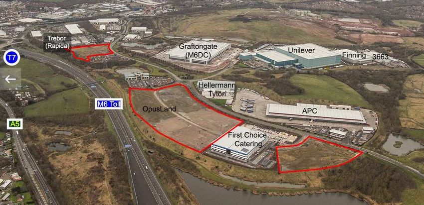
Strategic Rail Freight Interchange

Introduction

This evidence has been prepared by a local community group opposed to the West
Midlands Interchange proposed at Gailey, Four Ashes and Calf Heath in South
Staffordshire. The community group was set up to represent the views of local residents.
The group comprises of professional experts and local residents. It also has local political
support from Gavin Williamson (South Staffordshire MP) and Jeremy Lefroy (Stafford
MP).

‘Stop The West Midlands Interchange’ currently has over 2500 members from the
neighbouring communities that will be directly or indirectly affected by the proposed
development, these include the communities of Gailey, Four Ashes, Calf Heath,
Hatherton, Penkridge, Brewood & Coven.

We do not propose to repeat the objections made by the professional bodies, local
authorities and political leaders we are merely seeking to offer a local perspective
and provide our own views on this proposal, which is supported by evidence and
professional experts.

This report focuses on the Location of this development.

This report should be read in conjunction with the other reports prepared by the group on
the following matters:

• Planning and Green Belt

• Railway Infrastructure

• Highways – including Independent Highways Consultants Traffic Examination

• Health

• Environment & ecological issues

• Tourism / recreational issues

• Agriculture

• Supporting Information and

• Answers to the Inspector’s Questions.
                                            2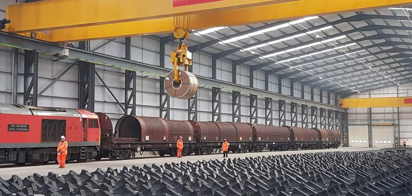
Strategic Rail Freight Interchange

SUMMARY OF OUR OBJECTIONS

This report examines reasons why this Location for an SRFI would be wrong.
It links in to the other reports prepared by the community group.

It considers the wrong choice of location from the viewpoint of legislation, regulation and
good practice. From Parish level through National policy to EU Directives and UN
recommendations.

It considers the physical and environmental constraints that make the projects location both
unsuitable and damaging. Road, Rail, Topography and Demographics.

It spells out the socio-economic ramifications of such a project and their negative impact on
the community. Jobs, Infrastructure, Community Facilities, Traffic.

It looks at how changes in conditions, business practice and other projects have rendered
the proposal out of date.

                                               3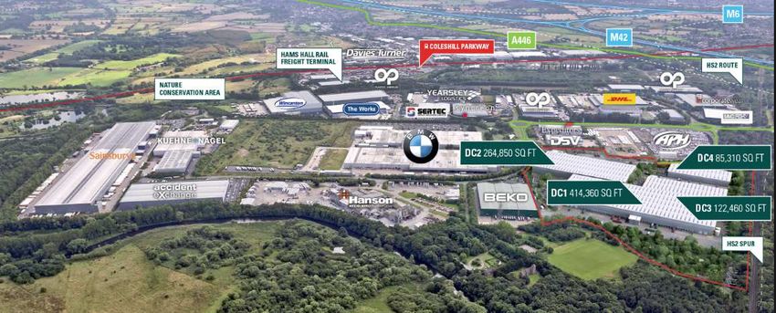
Strategic Rail Freight Interchange

WRONG LOCATION
This Proof of Evidence presents reasons why the choice of location is wrong; considerations
that may overlap with and elements that don't fit neatly into, our other report chapters.

1.       Application History
The WMI project history has Kilbride's Peter Frost exploring his way up the M6 until he found
a railway and a convenient few acres of farmland - probably helped by one of the frequent
traffic jams on this part of the M6.
In reality the site appears on various maps & databases and has been land owner driven.
The Monckton family own large swathes of land in South Staffordshire and have a particular
interest in changing the usage of their outlying lands into something that generates a quicker
and better profit than agriculture.
City trader Piers Monckton, chair of the Country Landowners Association, is desperately
trying to change a substantial area of his farmland & pheasant shoot into Logistics use.
Paradoxically he is an outspoken critic of HS2 cutting through the countryside¹
Commenting on the challenges faced by Staffordshire CLA members Piers said:
“Staffordshire has been the sacrificial lamb of HS2. The scheme adversely impacts broad
swathes of the county but brings precious little in the way of benefits""..”

The positioning of SRFIs is not based on government research and planning, which would
be much more logical (the Germans have a Rail Freight Masterplan2 for that sort of thing: Six
major Rail Hubs at six major cities: Hamburg, Cologne, Frankfurt, Heidelberg, Munich,
Hanover and many small RFIs).
Or like France’s Regional Master Plans; there the tendency is for large hubs on the outskirts
or dual usage facilities within city centres (three currently within Paris city)
In the UK, positioning has been left to private finance using a list of minimum guidelines (due
to lack of government funds or was the legislation influenced by vested interests?).
Thus it becomes one person or company’s choice of location against the wishes of
thousands of the local community. Money versus people.
If one was needed in this locale, Cannock is building a raft of distribution centres and other
big shed businesses with an RFI adjacent. Put them together.
                                      ------------------------------

2.    The unsuitability of WMI’s location is considered first through the hierarchy of
      political regulatory bodies:

Parish Councils
The Local Parish Councils that bound the application site strongly object to the proposal
They have also formed a Collective to strengthen that objection.
All have registered as interested parties to voice their objections.

South Staffordshire District Council (Host Authority / LPA)
The LPA strongly opposes the application.
South Staffordshire’s Site Allocation Document (SAD) has been approved by the Secretary
of State and was formally adopted in 2018. It does not contain reference to the site but
contains other land referred to as more suitable, such as the former Royal Ordnance Facility
(ROF) land close the i54 development.

                                               4
Strategic Rail Freight Interchange
The Black Country and Southern Staffordshire Regional Logistics Site Study4 was
commissioned to investigate potential sites and set policy. The WMI site was rejected.

Staffordshire County Council (Host Authority)
and Stoke & Staffs Enterprise Partnership
At County Level there has been considerable input relating to HS2 and its ancillary works.
Whereas Stoke-on-Trent is deemed to be the County’s economic core town and in greatest
need of employment opportunity, the proposed HS2 route has circumnavigated the city
because of engineering/cost issues; choosing instead, Crewe, as its major hub.

So given the dire need for a high employment project for Stoke (an SRFI possibly), their
reaction has been muted.
When our opposition group met Staffordshire CC’s economic growth leader Councillor Mark
Winnington, we were told that the County Council would take a neutral position.
Mr. Winnington, whilst Staffs & Stoke representative at the MIPIM 2018 in Cannes (as was
co-applicant Kilbride), actively promoted the WMI project.
MIPIM is advertised as the world’s leading property market.
Staffs CC’s Mark Winnington, & Wolverhampton City Council Director, Tim Johnson, jointly
presented the previously unheard of "M54 High Growth Zone" including the WMI project
and portrayed it as a "done-deal". The Inspectorate is referred to the YouTube recording:
https://www.youtube.com/watch?v=bLE_mFKNWOYf
Both West Midlands Interchange and Grosvenor Properties are portrayed as partners.
Towards the end of the clip we are told that:
Piers Monckton & the others “were about to receive Ministerial DCO consent later this year";
ending with a promise to potential investors "Tell us what you want and we'll give it to you..."

Black Country Core Group
Black Country definitions are likely to start fisticuffs, but the Black Country Core group is a
collection of adjoining Local Authorities with some shared industrial past: Dudley, Sandwell,
Walsall and Wolverhampton (not Staffordshire). The latter two (nearest) have expressed an
interest in proceedings. All are railway towns and contain considerable areas of current &
former rail land; including the large Bescot site straddling the M6 on the Walsall / Sandwell
boundary. Paradoxically they do not have rail intercommunication and road transport
between each is via heavily congested roads.
Wolverhampton is just setting up The National Brownfield Institute at the former Springfield
Brewery site - adjacent to large reclaimed rail areas used by the University. This will
become a national centre to support brownfield redevelopment.
Also at Wolverhampton, rail freight giant DB Cargo has just opened its ‘state of the art’
logistics centre - one of the largest investments in rail freight in the past five years10

                                               5
Strategic Rail Freight Interchange
Specialising in steel imports it is brought to the Knowles Road facility by trains from the ports
at Immingham, Hull and Boston.

Fig. DB Cargo Freight Terminal, Wolverhampton

The Black Country & Southern Staffordshire published a comprehensive Logistics report in
2013 -The Regional Logistics Site Study.
The Inspector is directed to its important content below or ref4:
http://www.wolverhampton.gov.uk/CHttpHandler.ashx?id=1638&p=0
It concluded that a comprehensive Midlands comparison should be made for sites; that the
Highways Agency advised against large Logistics developments near the busiest parts of the
M6. The WMI site in Greenbelt was deemed an unsuitable use.
A number of other potential sites were examined. The former Rugeley Power Station site
(opposite to the giant lorry-served Amazon warehouse) would have been perfect. However
with no interest shown in the last six years, the site owners are looking at housing options.
Also Pentalver’s RFI approved site at Cannock was amongst those recommended (below).

West Midlands Combined Authority (a grouping of the Midlands Authorities)
Although WMI have used the West Midlands title for strategic effect, it should be noted that
most of the site is in Staffordshire - to the north of the midlands conurbation.
Whereas older West Midlands residents get free train travel – Staffs residents have to pay!
Transport for West Midlands is the acting transport body for WMCA (bus/train/tram)
Midlands Connect and Midlands Engine are recently formed Quangos to facilitate
business and transport within the area. Their studies and transport policy do not incorporate
the WMI project but raise questions about WCML capacity.5

Transport for the North and the Northern Powerhouse are the equivalent quangos to the
midlands ones mentioned above. They also do not incorporate the WMI project in their
strategy. Despite the proximity of Manchester & Liverpool to our location, the northern
logistics strategy, their port and SRFIs have been completely ignored in the WMI
documentation.
The Inspector is directed to those northern freight policies6 with consideration for the SRFIs,
HUBs, Ports and airports already in place or under construction as part of the UK network
(particularly Liverpool, Manchester and Doncaster).

Telford, Shropshire and The Marches7

                                                6
Strategic Rail Freight Interchange
With limitations on their road and rail connections, those rural areas should not be
discounted from local transport planning. The Marches & Mid Wales freight report is very
detailed. Telford is the core economic township of Shropshire and regional growth point. All
freight is routed via or through that location.
The three areas cite Telford International Rail Freight Park (TIRFT) at Donnington as their
intermodal hub. It has been run by freight giant DB Cargo since 2012 (who has facilities at
Wolverhampton, Birmingham and Tamworth and DIRFT) and is also used by Freightliner for
Tarmac road stone transport from Telford to Hayes, Essex. The rail gauge is slightly limited
for high top containers but easily upgradable (certainly a better gauge than that approved by
the Secretary of State at Radlett SRFI). It is currently shortlisted for Heathrow Third
Runways offsite fabrication facility and there is a planning application pending for mass car
storage & transporting.8

2018 housing growth in Telford in particular, matches Cambridge as UKs highest housing
growth area7 as well as some significant industrial and commercial projects. Of course,
without the M54 northern link and better utilisation of TIRFT, much of that additional traffic
will head down the A5 Watling Street to the M6.
Approval of WMI would cause even more road traffic to head in this direction.

Figure: Telford’s Proximity to major Terminals

Cannock Chase District Council and the Area of Outstanding Natural Beauty
Cannock is a nearby town. Cannock Chase (AONB) is an ancient heathland and forest area
that has special protection and that of its surrounding views. The WMI proposal would harm
the vista. This is described in detail in our Environment Report and in the Cannock Council
and CPRE submissions.
Cannock is just clearing land for the McArthurGlen designer outlet village13 generating one
thousand new jobs.
A similar format to Clarks Village Outlets at Street, Chester and Ellesmere.

                                                 7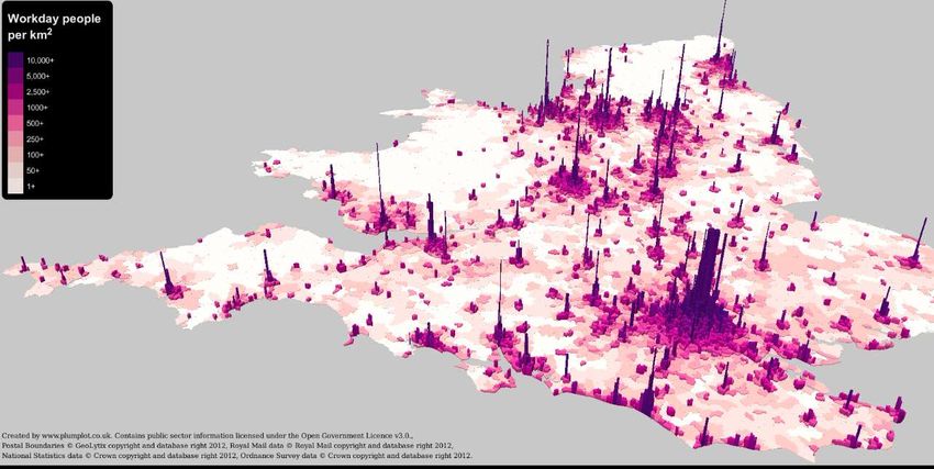
Strategic Rail Freight Interchange
Cannock / Staffs County has recently developed huge areas of former colliery land for
distribution centres (Kingswood Lakeside Employment Park and others).
Freightliner has an intermodal RFI at Cannock within 5 miles of the proposal.
Network Rail has re-signalled and electrified that line and was been testing it in late 2018.
Highways England raised clearance for the Strategic A5 at that location also. The facility has
been operating as a road based container hub for the last decade (Pentalver).
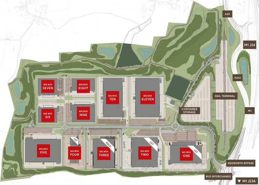
Fig. Cannock Kingswood Lakeside Employment Park with Freightliner RFI at the top left of
the picture.
One wonders why this group of buildings were not deemed an SRFI?
THE GOVERNMENT & NATIONAL BODIES
Parliament has debated and commented on rail freight issues numerous times in the last few
decades. The results are written into the framework of planning law.
The Government actively supports the transfer of freight to rail for the dual purpose of
assisting the rail freight network (decimated by the loss of coal transport – in contrast to
Germany who still utilise coal) and secondly to help reduce our carbon footprints under the
Paris Agreement for limiting climate change.
8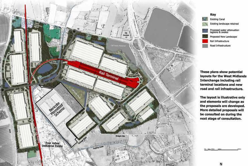
Strategic Rail Freight Interchange
Whereas the simple and laudable policy of moving freight from road to rail will undoubtedly
improve emissions and reduce congestion over a comparable journey; logistics must
consider the whole journey – most of which is not possible by rail. It cannot complete first
mile, last mile, or transport wide loads, long loads, high loads, or our local canal boats.

PLANNING LEGISLATION
Planning Act 2008 (PA 2008) introduced the concept and basic requirements for SRFIs
National Planning Policy Framework 2019 (NPPF 2019) Does not address SRFIs directly
but deals with Strategic considerations, Green Belt protection and Minerals protection.
National Policy Statement for National Networks ( NPSNN ) details the need for road,
The Strategic Rail Freight Interchange Policy Guidance ( SRFI PG ) – provided further
guidance and advice but has been superseded by theS..
National Networks National Policy Statement (Dec 2014) This indicates the importance of
the strategic road and rail networks and suggests priority work to improve them. SRFIs have
several pages describing their usage and importance. The NPSNN comments about the
Midlands being well served and London and the South not.
This is also echoed within European transport legislation and Transport for London reports.
Some of the figures & quotes tend to contradict its purpose such as: If freight carried by rail
was to increase by 50% (in terms of tonne kilometres) this would only be equivalent to a
reduction of around 7% in goods carried by road.

The National Infrastructure Commission stated in its Dec 2018 Future of Freight report:14
"Failing to plan and protect land for freight can result in logistics operators ‘sprawling’ further
from the centres of towns and cities, moving further from their end customers and increasing
delivery mileage, emissions and congestion. Although the issue lies mostly at the local level,
solutions through national frameworks could help head off future problems".
The Inspector is directed towards this current and very sensible report14

Network Rail
They are the final arbitrator of new rail connections and rail paths.
Network Rail's decisions are key to any rail related application via an eight stage process of
acceptance known as GRIP (Guide to Rail Investment Process)9
It is noted that whereas WMI originally quoted they were at GRIP stage 3.
It is now stated as only at GRIP 2.
Since GRIP 1 only involves registering a description; the WMI is still at the beginning of the
multi-year GRIP approval process.
This WMI is proposed for a deep cutting on a busy section of two track loop line with a
significant number of rail traffic pressure points. The likelihood of getting approval for a
connection and gaining sufficient freight paths is dependent upon Royal Assent for HS2;
then the latter being built before paths could be released on the West Coast lines; and who
else is bidding for paths.
Note that this is a heavily used passenger loop line not the West Coast main line.
Network Rail has collaborated with the WMI applicants to produce a Statement of Common
Ground (on the PINS application website). That document confirms the low level GRIP Stage
achieved; confirms the importance of HS2 being built to release freight paths and lists a
considerable number of caveats relating to time, duration and destination of freight paths -
together with critical requirements for access, maintenance and the importance of train
speed and acceleration to avoid the 125mph trains that already populate the loop lines’
timetable.

                                                 9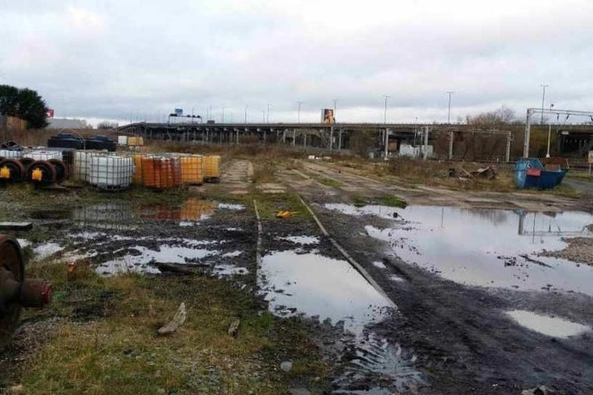
Strategic Rail Freight Interchange
There should be no possibility of approval for a project of this size below GRIP stage 5
otherwise there is no safeguard for design suitability and availability of paths.

            Overview of West Coast Main Line features above (not our West Coast Loop Line)

Below is an extract from material sent in reply from Network Rail after a request about WCML
capacity:

                                                 10
Strategic Rail Freight Interchange
Highways England
Highways England is a consultant and facilitator and does not tend to give general advice.
However in the Regional Logistics Site Study4 referred to earlier, the agency does advise
against locating sites within the busiest parts of the Strategic Networks due to over capacity.
Despite being classified as a Rural Motorway, the M6 at Gailey (j12) is also one of Europe’s
busiest sections of motorway and part of the Ten-T euro-strategic network.
Additionally our opposition group has engaged with them independently and at recent
consultations for a nearby link proposal with the M54 to M6 north. (Also generating traffic
problems and drawing on limited employees).
In its PINS submission the Agency explains the legislative and engineering impossibility of a
direct M6 connection and takes issue with attempts by the Four Ashes Group to control part
of the Strategic Road Network via its DCO wish list.
Highways England has also raised concerns about the WMI wanting a rail-less first phase of
just warehouses SS. without mitigation!!!
Are there any safeguards to prevent excuses such as: world economic downturn, Brexit,
HS2 delays, lack of rail paths, engineering problems or lack of money; allowing phase 1 to
be the cheap and cheerful final result and a nice little earner?
European Union
Prior to Brexit in March/April/May 2019? The UK has been the subject of a raft of European
legislation for transport. Much has been incorporated into our planning controls.
The Combined Transport Directive (92/106/EEC)15 is currently the EU legal instrument for
multimodal transport. Its aim is to increase the competitiveness of combined transport.
“Combined transport” means carriage of goods by a transport operation, consisting of an
initial or final road leg of the journey, or both, as well as a non-road leg of the journey.
(Otherwise known as Intermodal or Multimodal or Transhipment)
Since Neil Kinnock’s days in the EU transport office (1998) there has been progress towards
a pan-European transport network.
Today the requirements are under the umbrella regulations known as Ten-T.
Technical standards and key road, rail and waterway routes are identified together with ports
and airports within all EU Countries. There are also specific regions - of which we are in the
North Sea Mediterranean corridor and there are also considerations of congestion
(Birmingham is noted thus)
The order of importance is quoted as London-Paris-Brussels-Amsterdam forming the central
area of our corridor.16
A key requirement is for the nodes of the core network to have adequate road and rail
connections. Birmingham, Manchester and East Midlands airports are also required to have
dedicated road & rail connections. (Ten-T, Article 41 Part 2 Annex II ).
The UK is quoted as heavily dependent on the North Sea routing and is urged to develop
additional east-west routes. Liverpool Port is especially singled out for that. The
recommendation would open up the north of the country, however take up of the
recommendation has been slow.
11Strategic Rail Freight Interchange
Fig: EU Core Network Corridors (UK is in North Sea Mediterranean Corridor)
In the UK, rail upgrade requirements have been identified for Felixstowe-Nuneaton and
Southampton-Birmingham lines, the larger UK container ports and West Coast Main Line.
The Northern Hub project, centred on Manchester would involve major upgrades in terms of
capacity and electrification.
Development of Stations in Birmingham, Coventry and Wolverhampton are cited.
In Ireland, the major rail projects are centred on Dublin as their hub.
Ireland is a special case since almost all freight travels via England and there are traffic
implications if not loaded on to rail at Liverpool.
Nowhere in the Ten-T regulations is an intermodal hub mentioned or recommended
for our area and their critical hub positioning is based on multimodal hubs involving
road/rail/air/water16 - hence mainly port and airport related nodes.
Global Imperatives
Whereas Britain’s Planning Policy, the Ten-T and Combined Transport Regulations were
originally framed around mobility and trade; a growing understanding of man-made
environmental changes have altered the relative importance of some of those policies.
In 2016 the European Clean Energy Package was proposed to enact the Paris Agreement
(Paris Accord). That was refined into politically acceptable (but still voluntary) legislation at
the 2018 COP24 symposium held in Poland’s coal capital, Katowice.
Those agreements are being incorporated into policy, to control the escape of carbon dioxide
and other emissions. For the transport sector it basically spells the demise of the internal
combustion engine in favour of electric motors (or hydrogen).
Whereas road and rail can have identical propulsion systems, rail’s less interrupted journey,
greater capacity and low friction movement will always generate lower emissions on a
comparable journey.
12Strategic Rail Freight Interchange
Of course, when double handling, last & first mile distribution and diesel trains are factored
in, the calculation tends to even out.
Not only that, but pollution hotspots would be generated by the proposal.
But there are many dubious assumptions made with all such green calculations. Airport
pollution calculations only use the first 1000 metres of aeroplane movement; rail trips don’t
include fuel type, final destinations, train lengths, capacity and freight handling; road
journeys are usually just convenient guesses as to distance - with traffic queues not
appearing in analyses.
Even more frightening, is the little-regulated shipping sector.
It has been calculated that the 15 largest container ships in the world emit as much nitrogen
dioxide & sulphur oxide as the world’s total 760 million cars!17 .
Since so much of the UKs imports are from China there is little option other than to consume
less imported goods.
Whereas China’s impressive Belt & Road policy has created several rail paths from its
industrial heartland to Europe (including UK), analysts point out that it cannot compete with
shipping on volume or air freight for speed but has an intermediate level & cost but most
importantly a political networking purpose.18
------------------------------
PHYSICAL & ENVIRONMENTAL CONSTRAINTS
The unsuitability of the WMI location is considered below through the hierarchy of physical
constraints:
The Quarry Ploy
The Local Planning Authority rejected the Moncktons previous attempts for a Logistics
change of use and the family moved on to more elaborate approaches to bypass them.
Archaic Manorial rights were utilised to gain County level permission to commence stripping
the Grade 2 agricultural land for mineral extraction. Opposition was low because it was
promoted as a resource of strategic national importance.
CBI 2016 “The entire economy of the UK relies on minerals”.
But the mineral extraction at Gailey (on the WMI application site) has been in breach of its
planning conditions for some months.
Permission was granted based on phased re-instatement back to agricultural use.
Local knowledge indicates that even backfilling was abandoned several months ago.
The County Council has not taken any legal action - although they have been informed.
We would ask the Inspectorate to examine this situation (refer to earlier County concerns)
Minerals extraction is classed as, of National Importance and was consented on that basis.
That importance has been underlined in NPPF 2019 and The UK Minerals Strategy 201819
Using that partially stripped land as preparation for WMI would imply either a known outcome
(refer to earlier concerns about County) - or its a very arrogant assumption.
Equally shocking is the application statement that all mineral extraction would be abandoned
immediately if consent was granted!
To sterilise the minerals would surely be contrary to legislation that was used for granting
permission in the first place.
What is the primacy of three strategic calls on the land? Agriculture, Minerals, Logistics.
Minerals are irreplaceable & finite; Food is essential to life; Logistics pits companies against
each other to deliver cheap Chinese products, that we didn’t know we wanted.
13Strategic Rail Freight Interchange
Worryingly the Archaeological report states that two medieval earth barrows disappeared
after the quarry started. The A5 is of course a Roman Road, the confluence of Watling Street
& Via Devana (military Road XI) with Roman settlement Pennocrucium at the west end of the
site. The famed Anglo Saxon Staffordshire Hoard was discovered a few miles away.
A large area of woodland (mainly hardwoods including black poplar) has also been felled
without permission, adjacent to Four Ashes. The Forestry Commission has taken some
punitive action.
Refer to our Environment Report for additional coverage.
14Strategic Rail Freight Interchange
MISCELLANEOUS OBSERVATIONS:
The provision of Strategic Rail Freight Interchanges has come about via a hierarchy of
legislation and European & Global Imperatives
1. The proposal does not create a viable rail interchange let alone a Strategic one .
NPSNN states: It is not essential for all buildings on the site to be rail connected from the
outset, but a significant element should be.
When the local community was first informed of the huge project they were shown two very
different layouts and asked which option would you prefer - hoping the public would "vote"
for the only workable one?
The "frightener" version showed true rail connectability (on plan) .... but was a red herring -
that could not be built due to the large level differences and obstacles (such as a canal).
The current design is merely a collection of road-served warehouses nudging a minor 2 track
loop line railway.
Only two small sheds are shown as rail served - to desperately try and justify the SRFI title.
Large level differences compromise this site.
Fig. This early plan for WMI showed improved rail connectivity
2. The proposed site is in an area of low population and low unemployment, but next to
some extremely busy strategic roads - that would be completely gridlocked if the WMIs
predicted traffic surcharge were allowed.
15Strategic Rail Freight Interchange
Fig. Worker Population of UK – showing our quiet location © Plumplot Royal Mail Data 2012
3. The WMI proposal is in an area with a small consumer base and minimal production
facilities. At best it could only act as an intermediate staging post in a supply chain thus
generating huge last-mile traffic (not shown in the WMI traffic data).
Intermodal facilities need to be at ports; in or near large cities or massive users to operate
efficiently and without causing disruption.
NPSNN Table 4 It is important that SRFIs are located near the business markets they will
serve – major urban centres
NPSNN 4.13 .... and so the location of development will usually be determined by
economic activity and population and the location of existing transport
Networks.
Fig. Heat Map of Warehousing&Industry in England (Stowga)
- showing the lack of activity in our quiet area.
16Strategic Rail Freight Interchange
Fig. An Ordnance Survey Map showing Light Pollution ". and lack of, in our area
4. Bulk freight and long distances are where the real economies of rail freight lie.
There is no bulk freight potential for this site.
The staple bulk rail freight in UK has been coal, which is almost phased out in UK.
Viewers of TV programme Australia Railroad will not see any multi-day journeys; 1000m+
long, double decker freight trains here.
Regarding distance, the UK is very compact and most experts consider rail freight transport
to be uneconomical and/or unviable with journeys of less than 100 miles.
The EU Commission stipulates that the minimum distance for multimodal trips should be
300 kms / 186 miles, below which transhipment costs & time render it unviable.
Of this they recommend the maximum road distance to be 150km – with tolerance to use a
specific terminal/ node / destination.
Those distances need to be considered with regard to our location and that of ports, existing
SRFIs & nodes and potential end users.
5. Other than bulk freight, domestic intermodal freight is stated in the NPSNN to be the only
area of rail freight that will increase, other than Ports traffic and specialisations.
Domestic Intermodal is basically shipping container traffic swapped between train and lorry.
The containers "origin" may be domestic or from Ports, eg. imported goods.
Whereas most HGVs seen on our roads and motorways are 40 or 44 tonne curtain siders;
shipping & rail freight demand modular steel containers with a hardwood ply floor. The slow
growing tropical species used for the floors are being decimated by excessive demand.20
Containers are carried on a type of flatbed type trucks with a quick release swap system
allowing the (40ft) containers to be easily removed. Ships bring in 5000 to 9000 each trip.
The fuel burned by container ships exceeds that used by all diesel trucks and trains in UK.17
6. With reference to the catchment areas of established and proposed SRFIs, there seems
to be more than adequate coverage for the Midlands in general and most definitely sufficient
for this area, without the WMI.
Golden Triangle Map and Catchment Area Map below were produced by Northampton
Gateway.
17Strategic Rail Freight Interchange
Policy documents all refer to the lack of SRFIs serving the London and the south and surfeit
in the midlands. The only two southern "approvals" are likely to be used by Heathrow 3rd
runway (Colnbrook) and (Radlett) blocked by local community, District & County Council –
possibly now earmarked for housing.
Most other SRFIs are placed (logically) in or adjacent to very large conurbations, ports or
within the logistics industry's preferred location - the Golden Triangle - the logistics
industry’s perfect siting for national access to business, road & rail transport links and ports.
18Strategic Rail Freight Interchange
The Department for Transport (DfT) states in its Market review and Modal Shift Assessment
that the Midlands is well served for Intermodal Terminals.
Similarly the NPSNN states:
Para 2.56 It is important that SRFIs are located near the business markets they will serve –
major urban centres.
2.57 Existing operational SRFIs and other intermodal RFIs are situated predominantly in the
Midlands and the North.
2.58 There is a particular challenge in expanding rail freight interchanges serving London
and the South East.
Refer to data sheets describing other SRFI in the Appendix.
7. It is noted in the WMI application that the alternative sites / sequential test has not
generated as many suitable sites as similar rail hub applications; eg. Rail Central. 25
The latter scored WMI reasonably (as it did a number of alternative sites) on the PA2008
basic requirements, but it was sieved out of the assessment due to being in Green Belt.
Similarly DIRFT III raises the point that one of the critical Green Belt tests is that the very
special circumstances must show the inability for the proposal to be accommodated
at an alternative location. This does not hold true for the WMI site.
Whereas a developer’s true answer would be "we don't own the other land so are not
interested in rating it well". It is essential that alternative sites are fully investigated.
We ask the Inspector to question this. To include the nearby ROF site and others at Stoke,
Burton, Rugeley and Telford. As Network Rail state:
“There are hundreds of freight sites with connections to the rail network, as well as land in
railway industry ownership with the potential for a new connection”
Many intermodal locations are owned by other logistics interests. The rail freight industry is
carved up between foreign rail freight companies: German Deutsche Bahne Cargo, US
Gennings Wyoming Freightliner, French Colas, Swedish GB Railfreight, and sole British
player Direct Rail Services (formerly British Nuclear Fuels Freight).
There are secondary users & facilitators such as DHL, Malcolm Freight and Stobarts who
also have land or operational interests. EU legislation seeks to open access to all sites.
Of particular concern is that freight paths are considered valuable assets and are bid for and
retained even if not used. Network Rail has been unsuccessful in preventing the practice.
8. Network Rail’s map below from their freight policy document indicates how intermodal
freight might flow in 2030 from the major Ports. Channel Tunnel omitted?
Whilst showing only rail regions the Midlands & South Midlands takes the lion’s share of
container traffic. Transport for the North has more detailed data.6
The map does not show any receiving centre for London and the South S.. this would be a
failure of policy.
19Strategic Rail Freight Interchange
Worryingly this is in accord with analysis of Freight for London by London Reconnections:
“The first thing to know about rail freight in London is that most of it goes through, even if
some of it goes up to distribution centres in the Midlands and comes back in lorries.”
The Inspector is directed to their series of three very informative reports, which although
south-centric, contain useful information for further up the tracks.22
Fig. The DfT 2031 Rail Freight Routing Projection examines paths in more detail:
9. There are several viable RFIs that could serve our local area. Telford and Cannock are
particularly relevant (as mentioned in the local political section) and there are other potential
20Strategic Rail Freight Interchange
sites where employment is desperately needed (Stoke: Etruria & Other), that have not been
investigated thoroughly. Also the ROF site with Hilton Park in South Staffordshire.
Wolverhampton has not been thoroughly investigated for potential rail connected sites.
10. Traffic Flow Calculations. The applicant’s calculations do not appear to have taken into
account the physical size of the trucks (2.5 x car units) on the short lengths of road. eg. the
A5 is proposed to be split between Gailey Island and M6 j12.
The overspill generated will quickly compromise the M6 and adjacent Strategic roads.
The long daily queues of traffic at peak times do not appear in the applicant’s VISSIM
calculations. As locals, we are aware of them as a twice daily occurrence.
The definition of a traffic queue as used in those calculations must be defined.
11. The internal flow of traffic, especially from the "necessary" internal site distribution of rail
freight arrivals via the proposed link road has not been allowed for in traffic flow calculations
– nor has the 30mph limit on the link road (versus 50 for the existing roads).
12. The effects of other large on-stream projects at Cannock, Featherstone, Rugeley and i54
and the M54 link have not been considered with regard to traffic flow, resources and
employment. Neither has the recently built Four Ashes factory of Spanish metal pressings
producer Gestamp (relocating itself and its traffic from Cannock).
13. The proposal would generate huge construction traffic movements at the same time as:
M6 Smart Motorways works are continuing, ROF site works commence, Cannock Designer
Village being built; Rugeley Power Station re-development; the new M54 to M6 & Toll Road
links being built and the nearby building of HS2 and its related facilities at Stone.
The whole region would be compromised.
Yet the GRIP stage of the proposal is at level 2 of 8 (Option Selection) - suggesting that
approval of a new freight connection and rail paths is nowhere near guaranteed and may
take years to progress. So no rail assistance only HGV traffic.
21Strategic Rail Freight Interchange
14. If the proposed employment levels were accepted as accurate, there is insufficient
information as to where those employees would come from and how?
NPSNN 4.87: SFRIs can provide many benefits for the local economy. For example because
many of the on-site functions of major distribution operations are relatively labour
intensive,this can create many new job opportunities. The existence of an available and
economic local workforce will therefore be an important consideration for the applicant.
(Locally impossible – a small population & very low unemployment therefore no benefit)
15. If the proposed employment levels were accepted as accurate predictions, there is
insufficient provision for public transport, sewage and other infrastructure and facilities for the
numbers shown in the application.
16. If the proposed employment levels were considered to be overestimated (the profitability
of the logistics industry hinges on minimum employment and maximum automation ) - then
where would the socio-economic benefits to the area come from?
Viewers of Inside the Factory and Secrets of the Factory are made aware of how few people
are actually employed in Britains manufacturing facilities.
A waste incinerator was located at Four Ashes industrial site some two years ago and is
operated by French company Veolia. A substantial facility - but it only requires a dozen staff,
ie. negligible contribution to local employment. Note that waste is being brought from Walsall
and Wolverhampton and burned at this South Staffordshire facility, increasing local pollution
again with no visible community benefit.
17. If the proposal is for a rail connected SRFI (the only way to get it into the Green Belt),
then why does it show a "first phase" of non-rail connected warehousing as ribbon
development along the A5 ..... without rail connection .... or any railway facilitation works.
If rail intermodal transfer is the desired purpose then that would surely be the essential (and
required) first phase. Otherwise what safeguard would there ever be for an intermodal facility
to follow? Imagine what excuses could appear!
NPSNN 4.88 The initial stages of the development must provide an operational rail network
connection and areas for intermodal handling and container storage. It is not essential for all
buildings on the site to be rail connected from the outset, but a significant element should be.
18. Whereas severe planning blight stemming from such a large speculative & phased
application is not an allowable planning objection; we would still direct the officer's attention
to the declared socio-economic benefits and to those DCO boundary red lines forming
"islands" isolating dwellings and communities in a permanently depressed state.
HS2 addressed that from the outset.
19. The provision of SRFIs as promoted by the government originally stated that due their
size and nature it may be necessary to site these in countryside or greenbelt. This was been
revised in the NPSNN to "it may be that countryside locations are required for SRFIs"
indicating that the use of greenbelt is much less reasonable.
22Strategic Rail Freight Interchange
NPSNN 4.84 and 5.172 Promoters of strategic rail freight interchanges may find that the only
viable sites for meeting the need for regional strategic rail freight interchanges are on Green
Belt land.
Promoters need to recognise the special protection given to Green Belt land. The Secretary
of State would have to be convinced, and promoters would need to demonstrate, very
special circumstances to justify planning consent for inappropriate development in the Green
Belt (see 5.178). The 2019 NPPF reinforces this also.
20. The definition of an SRFI requires that logistics should be alongside major rail routes (not
2 track loop lines) and near to the conurbations that consume the goods (which would not be
the case) NPSNN p2.45
Fig. The West Coast Main Line requires regular night time maintenance
usually closing two tracks. We only have two!
21. It is often thought by those that don't see or hear them, that the M6 or Rail lines are quiet
during the night. As the picture above shows, rail maintenance is normally carried out at
night, as are (slow) freight movements. The M6 never sleeps; a slight lull at 10pm is followed
by a surge of newly filled HGVs at 11pm from distribution centres. The next few hours
consists of mainly commercial traffic - sometimes flowing, sometimes overflowing back on to
the A5 and A449 as motorway roadwork’s (also carried out at night) and accidents (no hard
shoulder here) compromise that flow.
By 5am both the commuter surge and the early start HGVs begin again.
Only the M6 Toll is quiet at night.
22. Community Impact
NPSNN 2.51 The environmental advantages of rail freight have already been noted at
paragraph 2.40 and 2.41 Nevertheless, for developments such as SRFIs, it is likely that
there will be local impacts in terms of land use and increased road and rail movements, and
it is important for the environmental impacts at these locations to be minimised.
The location of the WMI is where the M6 and A5 are running significantly over designed
levels for all traffic. The M6 is one of Europe's busiest roads.
Similarly the Birmingham Loop Line Railway Track is also at its limits without major
assistance and path re-structuring.
So, there is already no scope for a major increase in traffic in either mode, let alone the
gigantic increases presented by the proposal.
23Strategic Rail Freight Interchange
As a consequence of the size of the project and the previous observations, environmental
overload would certainly occur if the project were to gain consent.
Devastating gridlock would be inevitable.
The fragility of the system is quite obvious when a HGV stops and turns into the fuel station
on the A5 - causing an immediate traffic jam. Previously, (2 years ago) the fuel station did
not accept HGVs. Now most large Council vehicles have an account there.
Its position would work in opposition to the link road. Below is a familiar traffic map:
23. Our area is rural, even our section of the M6 is classed as a rural motorway by Highways
England. However the traffic in the last decade has increased significantly due
developments at Cannock and Telford and the inadequacy of the M6 and its frequent road
works and accidents.
Much of our area does not have gas supply and much of the electricity supply is from
overhead lines.
There is little public transport. Whilst Penkridge is a busy village hosting a twice-weekly
market, the big banks have closed their rural branches following the last financial scandal.
There is a rudimentary bus service between Stafford - Penkridge - Wolverhampton, but
personal transport is virtually essential.
There are two Co-op supermarkets, a Sainsbury mini-mart and a Farm Store.
Those stores require about one container-load of deliveries a day between them.
The huge predicted increase in commuting workers required for construction, then the
operation of the proposal, would swamp local infrastructure: police, ambulance, fire, doctors,
dentists schools and infrastructure as well as compromise those already commuting through
the area.
24. The proposal (to mitigate the loss of surrounding fields, trees and landscape) has
proposed two "community parks". Let’s call these: Pylon Park and Pollution Park.
Pollution Park would be that shown on the A5 near Croft Lane, subject to the greatest
increase from vehicle emissions and brake dust.
(Four Ashes Ltd, to release more space for warehousing, propose removing electricity
pylons and burying the high voltage cables).
Pylon Park near Calf Heath, would be positioned exactly where the HV cables transition
between underground and over ground. ie. Which would not be commercially acceptable?
24Strategic Rail Freight Interchange
25. It is noted that adjacent Local Authorities Walsall and Wolverhampton have expressed
an interest in the WMI project, despite the objections of the specific LPA (South Staffordshire
District Council).
Officers should note that both towns are historically Railway towns and both still have
significant (disused) rail yards but have also actively compromised some of their rail yards,
allowing housing or commercial development on them.
Wolverhampton has a large rail freight terminal for steel run by DB Cargo.
Walsall, at its border with Sandwell, contains the very large brownfield site of Bescot (picture
below) comprising derelict railway sidings and marshalling yards.
Network Rail is hoping to use a small part of the site for making concrete railway sleepers -
surprisingly specifying HGV only movements to bring in materials, presumably because it is
impractical and unviable to use rail for short distances, last-mile trips and specialised uses.
26. The Last Mile or Final Mile Conundrum. (Or First Mile!)
A logistics term for the last part of the trip from interchange to end user (or vice versa). Likely
to be the most inefficient and pollution generating part of the article's journey.
NPSNN 2.49 Indicates that the Government has accepted the figures in Table 3 (rail freight
usage) as robust and suitable for planning purposes. Those figures indicate that the only
non-port growth in rail freight will be the domestic intermodal category (all other sectors are
static or declining eg. coal).
Domestic intermodal is basically shipping containers (of consumer or commercial items).
Without a nearby large user/consumer base (or major producer) the facility simply becomes
a temporary store or staging point that generates traffic chaos and inevitable carbon
generation as it travels its final mile(s).
There is no close consumer base here requiring (or producing) such large quantities of
deliveries. And regardless each full train load is supposed to be the equivalent 76 HGV
loads. Part loads are neither viable nor desirable.
25Strategic Rail Freight Interchange
So each train would require at least 76 empty HGVs to arrive (from?), to be loaded and 76
laden HGVs to depart to (miscellaneous destinations?) via the busiest section of the
motorway.
Or perhaps 200+ vans could be used.
At least 4 trains are required by legislation with 10 per day quoted by WMI as possible.
This is conveniently omitted from carbon calculations.
Of course if the loads and destinations were not matched then the vehicle number would
increase and viability would be lost.
26. The principle of fully laden 775m freight trains transporting containers or bulk products
from Southampton up to the north of England and Scotland or shuttles from London
Gateway Port to an eventual London SRFI, is what the system and hopefully the aim of the
legislation is all about.
Not the abuse of the word "strategic" to bypass LPAs and shoe horn warehousing into green
field and green belt sites via legislation written by the parties involved in the business,
profiteering under the guise of preventing climate change.
27. Britain does not have a good track record with vehicles and transport. Virtually all road
vehicles are produced by foreign companies. The history of our own industry is one of inept
or greedy mismanagement. The last debacle was the diesel vehicle promotion of 2001 and
before that the Toll Road scandal.
Even the Bloodhound land speed record vehicle was scrapped due to lack of funds.
Since the Dr. Beeching cuts and the privatisation of railways, almost all rail freight
companies are foreign owned.
There are many older railway engines still running with 30 year old polluting diesels and
virtually all modern locomotion is foreign produced. See para 30.
There are even a number of railway engines currently being retrofitted with new diesel lorry
engines. Network Rail to explain.
It is a sad & embarrassing history that should have lessons to be learned.
Let’s not make further mistakes for short term gain, in an economy with little underpinning.
28. Also consider that any new industry foisted upon our area is unlikely to be new. It would
almost inevitably be shifted from another location. Tempted by financial incentives, the need
for bigger premises, modernisation, change in business patterns, etc.
26Strategic Rail Freight Interchange
Even leviathans like Amazon usually only rent on a 10 year basis and then re-assess.
(interestingly their massive base at nearby Rugeley has made no move to connect to rail
despite the long-time availability of the disused power station track adjacent. They have
found it necessary to bus-in most of their work force from as far away as Birmingham.
So some other area would lose 1000's of their jobs in order to re-locate to our area...... an
area with very low unemployment ........ or it becomes necessary to bus those 1000s in (as
Amazon does from Birmingham).24 Or automation could remove the employee problem but
demolish any socio-economic benefits.
29. Can lessons be learned from the EU? Europe’s largest rail freight market, Germany, has
a Rail Freight Masterplan. It states for the positioning of their "strategic" rail hubs:
Today, the six major rail hubs (Hamburg, Cologne, Frankfurt, Mannheim, Munich, Hanover)
are already at virtually full capacity. Upgrading these hubs will remove bottlenecks, thereby
reducing service disruption and making it possible to ensure that additional movements can
be handled as planned.
The rail hubs in most first world locations are located in cities (where the population requires
them). In USA, last mile distribution is causing serious problems. Under consideration are
using empty town centre shops & offices as distribution and collection facilities and severe
delivery restrictions..
30. Diesel versus electric traction. Extract from Network Rail Nov 2017 Freight Forecast:
“No assumptions have been made in terms of a possible switch towards more electric
traction, and our cost models are based on the use of diesel locomotives. This can
be interpreted as an assumption that electric traction will not offer significantly lower
costs when all its limitations are taken into account. The market would appear to
bear this out in the short term, given that new diesel locomotives are still being bought
by the commercial freight operating companies.
However it is unlikely that by 2023/24, bimode or electric-only locomotives will have
made significant inroads into the predominantly-diesel locomotive fleet.”
So Diesel it is and no mention is made of environmental impact.
https://cdn.networkrail.co.uk/wp-content/uploads/2018/10/Rail-freight-forecasts-final-
report.pdf
31. The Daventry International Rail Freight Terminal DIRFT is mentioned numerous times in
the WMI application - modelling itself on the project and quoting its traffic and transport
figures. Developer ProLogis in their planning submission to PINS for DIRFT 3 (proposal
statement p.03) suggests they are wanting to create an expansion of the existing facility to
avoid the disruption of a new site like WMI propose:
“The team believes there are clear benefits of expanding DIRFT compared to the
development of a new site which would create greater disturbance and environmental and
social impacts.” We agree.
It is also critical of sites attempting to use Green Belt for inappropriate development.
32. Referred to in our Environmental Report, it is of concern that there is substantial ground
contamination (especially Phenols) recorded in the western section of the proposal26. It is
further noted by Network Rail in the Common Ground document.
32. It is clear from the applicants trip figures that the facility would generate considerable
CO2, CO, NO2, SO2 & lung damaging particulates (obviously much more than if the facility
wasn’t built). The applicants will resolutely argue that parliament has stated that more SRFIs
27Strategic Rail Freight Interchange
should be built therefore it is fulfilling national need - and just as worryingly, the box ticking
nature of carbon reduction targets also favours such simple acceptance.
So the test is:
• whether the proposal at this location, with 85% of its warehousing unconnected to
rail and sited on greenbelt farmland, can be deemed an SRFI and does it demonstrate
any special circumstances whatsoever and show any national, financial or
environmental benefit over & above the dozens of other road based warehouses in
the region that are not on greenbelt farmland;
• whether the proposal at this location would provide any socio-economic benefit to the
small local community - we see none;
• whether the proposal at this location, could demonstrate a national improvement in air
quality or economy; when the uneconomical rail distance from major conurbations or
ports, the indisputable "final mile" problem and the transhipment double handling are
factored into carbon and air quality calculations.
• whether the proposal at this location, (on a busy passenger line with limited freight
paths), would compromise (increasing) passenger train operations and would
jeopardise other nodes correctly situated near to large conurbations and areas that
cry out for jobs (eg. Stoke).
• whether HS2 will go ahead with the current economic downturn.
• Whether the A5 and M6 would be hopelessly compromised by the HGV overburden if
WMI went ahead.
--------------------------
5. FUTURE CONSIDERATIONS
1. Our farmland is as strategic (if not more so) as our transport. Mineral extraction has been
allowed on part of it under the argument of being of great national importance.
So are intermodal freight hubs now being touted as being of still greater strategic
importance? What of Agriculture? What of Green Belt?
Under that hierarchy, basic human needs should be re-appraised!
Considering that road – rail modal change is directly or indirectly climate change driven; then
agricultural resilience, the protection and preservation of our farmland and food source must
surely be more important. Should climate change effect warming sufficient for sea levels to
rise there would be considerable land loss on the east coast thereby ranking central and
western farm land as an even more important resource.
28Strategic Rail Freight Interchange
Leaving the EU and having to find new sources for food produce, whilst global production
becomes more stressed, is surely demanding of increased protection for already established
farmland. The 2019 NPPF reaffirms the point.
2. In consideration of other SRFI projects in position, being built or entering the planning
system, is the facility is needed anyway? Do on-going national and global changes render its
purpose un-necessary or unsuitable?
The network of SRFIs already built or in progress, will fulfil the logistical requirements of all
but the most populous locations in UK. Only Greater London is badly served. So the benefits
of a further scattering of huge SRFIs will have already passed its sell-by date like out-of-town
supermarkets.
3. The WMI proposal quotes a building programme in excess of 15 years (running alongside
all the other major building programmes in the region). (Any first phases or initial buildings
has no SRFI status – so zero or negative impact or benefit.
By then priorities, policies, solutions, Europe and indeed the world, will have changed.
The European Directive that created the requirements will shortly be revoked when Britain
leaves the EU in March/April/May/JuneS
The (voluntary) Paris Accord plan can only be achieved through considering population, food
production, consumption and active carbon capture. Improvements in transport are already
in the pipeline they will achieve much more benefit than new warehouses can.
4. There is already a marked global downturn and the commercial part of sub-prime bank
dealings is just about to bite.
China’s economy has slowed down considerably and is turning inwards now its own
consumer base has reached a certain socio-economic critical mass. They have the main
parts of their Belt & Road strategy in place and their own resilience is therefore guaranteed.
29You can also read