PROVIDING TRAIL INFORMATION TO PEOPLE WITH DISABILITIES - GUIDELINES FOR - October 2013 - Access ...
←
→
Page content transcription
If your browser does not render page correctly, please read the page content below
This is a picture of Georgena at
the trail map kiosk at the Tualatin
River Wildlife Refuge with other
people looking on.
                                      GUIDELINES FOR
                                      PROVIDING TRAIL
                                      INFORMATION TO
                                      PEOPLE WITH DISABILITIES

                                      October 2013
                                      Revived and refreshed April 2020, but not revised.
Cover Contents Summary Primary Secondary Examples More topics Glossary Resources
Back to cover Next page
This is a picture of Georgena at
the trail map kiosk at the Tualatin
River Wildlife Refuge with other
people looking on.
GUIDELINES FOR
PROVIDING TRAIL
INFORMATION TO
PEOPLE WITH DISABILITIES
A project of the
Access Recreation Committee and
Independent Living Resources
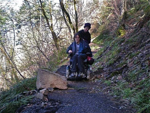
This is a picture of Georgena
trying to get around a large rock
obstruction along a trail.
Funded through a generous grant from the
Recreational Trails Program of the
Oregon Parks and Recreation Department
October 2013
Revived and refreshed April 2020, but not revised.
ⓒ 2011 - 2020 Access Recreation Website by Architectural Webdesign Powered by Rage EverWeb
Back to cover Next page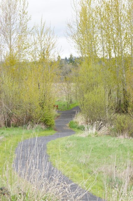
Cover    Contents     Summary     Primary   Secondary        Examples   More topics   Glossary   Resources

   Previous page                                                                               Next page
                                  AR logo Access Recreation; this page is Credits and acknowledgements

                                  Georgena Moran, Access Recreation project coordinator, for
        Credits and
                                  providing the original vision of what would enable people with
 acknowledgements                 disabilities to enjoy outdoor recreation in the Pacific Northwest.

      As with any complex         The Access Recreation Committee of public agencies and non-
    document, this project        profit entities that have supported this effort from the start.
    represents the effort of      A generous Grant, in 2011, from the Recreational Trails Program
        many people and           of the Oregon Parks and Recreation Department.
      entities, a short list of
       whom and which is          Independent Living Resources for its support and guidance.
            provided here.        The core subcommittee that developed the structure and the
                                  text of these Guidelines, consisting of:
                                  • Danielle Bailey, Oregon Health Sciences University
                                  • Richard Bosch Architect, accessible design specialist
                                  • Angela Butsch, US Fish and Wildlife Service
“It's been a long time coming     • Nickole Cheron, City of Portland
but there should be no            • Chuck Frayer, US Forest Service
remaining reason not to           • Greg Hawley, Portland Parks and Recreation, Hoyt Arboretum
implement such a simple and       • Erin Hesby, Access Recreation project facilitator [emeritus]
elegant solution to               • Patricia Kepler, Independent Living Resources
information sharing!”             • Sharon Mitchell, Access Recreation project facilitator
                                  • Georgena Moran, Access Recreation project coordinator
“Excellent presentation and       • Dana Perez, US Fish and Wildlife Service
such a huge asset to our          • Eric Rosewall, The Intertwine
field. Thank you!”                • Debbie Timmins, Portland Parks and Recreation [emeritus]
                                  • Richard Walkoski, Oregon Parks and Recreation Department
“...very informative              Tualatin River National Wildlife Refuge, Tryon Creek State Park,
presentation/appreciate           Metro, Independent Living Resources, and the City of Portland
methodical organized              for providing meeting space and presentation facilities.
thinking that was presented”
                                  Richard Bosch and Eric Rosewall for their hard work to further
“As a local park agency           develop these Guidelines and their expertise to publish these
manager, who has followed         Guidelines as a web-document.
this work from the beginning,     Additional support from:
I find the information from       • Barry Fox-Quamme, Independent Living Resources, director, for
this document to be                 his indefatigable energy to administer the Grant
embarrassingly simple!“           • May Altman, Independent Living Resources, project liaison
                                  • Bret Westwood, Oregon Vocational Rehabilitation Services,
recent comments from ORPA           past director
        and WSTC attendees        • Roslyn Farrington, All About Community, project consultant

   ACCESS RECREATION GUIDELINES FOR COMMUNICATING TRAIL INFORMATION TO PEOPLE WITH DISABILITIES

   Previous page                               Page i of vii                                   Next page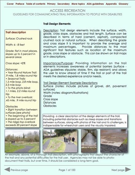
Cover   Contents   Summary    Primary   Secondary      Examples   More topics   Glossary   Resources

 Previous page                                                                          Next page

 AR logo Access Recreation; this page is the foreword by Georgena Moran
 A message from Georgena Moran, Access Recreation Project Coordinator

 Living in Portland, Oregon, I feel fortunate to be surrounded by so much natural beauty
 and to have such great hiking and outdoor resources all around me. But, as a wheelchair
 user, I also feel the frustration of not having access to reliable and meaningful information
 about those hiking opportunities. I feel that printed materials and online resources vary
 greatly in the information provided and often are offered with little understanding of what
 is most useful to people with different types of disabilities.

 My belief is that there are actually many trails that could be used by people with
 disabilities, but what is lacking is the information to make an informed decision. The
 concept is simple and empowering – people can make their own determinations if they
 are just provided the right information. Conversely, it is frustrating to make the effort to visit
 a site only to discover that it is unusable and perhaps for the most inconsequential reason.

 Several years ago, I decided to improve that situation and convened a team that
 included representatives from federal, state and local parks departments to develop
 common standards for providing information that would better inform people with
 disabilities.  This Access Recreation Committee developed Guidelines based on its
 collective experience and with the expectation that public agencies in the region would
 strive for a common standard of trail description and information sharing.

 A generous grant in 2011 from the Recreational Trails Program of the Oregon Parks and
 Recreation Department has now made it possible to further develop these Guidelines and
 to publish this web-document. These Guidelines do not propose to alter existing trails as
 much as to improve the quality of information that is provided about them. The team is
 sensitive to the difficulty public agencies have to implement many new programs, so the
 underlying premise was to divide the Guidelines into two phases: 1) primary information
 that can be provided readily and at no cost to the respective agency; and, 2) additional
 information that can be added over time as funding becomes available.

 I hope you will find as much benefit from our effort as the enthusiasm we have felt in
 assembling this document for you.

 Sincerely,

 Georgena Moran
 Georgena Moran
 Access Recreation Project Coordinator

 ACCESS RECREATION GUIDELINES FOR COMMUNICATING TRAIL INFORMATION TO PEOPLE WITH DISABILITIES

 Previous page                            Page ii of vii                                Next page
Cover   Contents   Summary     Primary    Secondary       Examples      More topics   Glossary   Resources

 Previous page                                                                               Next page

                             This is the Table of Contents with every page linked
                             Cover page
 Table of Contents
                             Credits and acknowledgments
                             Foreword
                             Table of contents
                             Summary       Purpose, methodology, organization of content
                             Section 1     Primary trail information - overview
                                           Contact information
                                           Location
                                           Use of symbols
                                           Rating systems for ease and difficulty of use
                                           Describing amenities along a trail
                                           How to describe the character of the trail itself
                                           Trail design elements
                             Section 2     Secondary trail information - overview
                                           Keeping information current with user feedback
                                           Providing photos and graphics
                                           Providing trail maps
                                           Interactive maps
                                           The use of global positioning GPS
                                           Distance markers
                                           Signage and wayfinding
                                           People who are blind or visually impaired
                                           Operational and maintenance issues
                                           General advice and reminders
                             Example webpage of these Guidelines in practice
                             Section 3     More topics related to people with disabilities
                                           Considerations about language and semantics
                                           Additional information about wayfinding
                                           Federal trail design guidelines compared
                                           Accessible website considerations
                                           How a computer reader works
                                           Self-evaluation checklists
                             Glossary of terms
                             Additional resources

 ACCESS RECREATION GUIDELINES FOR COMMUNICATING TRAIL INFORMATION TO PEOPLE WITH DISABILITIES

 Previous page                              Page iii of vii                                  Next page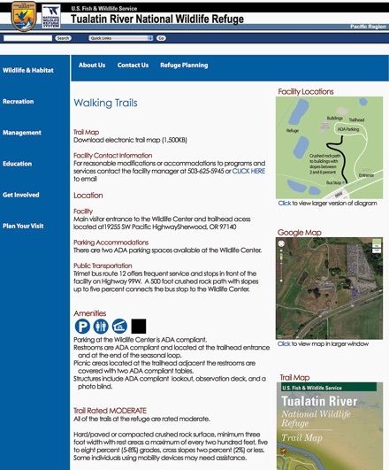
Cover    Contents      Summary           Primary   Secondary     Examples    More topics   Glossary   Resources

 Previous page                                                                                    Next page
This is the first page of the preface.
                                    This is the first page of the preface.
                                    What is this document all about?
          Summary 1
                                    This web-document provides guidelines and additional
                                    information that public agencies and other non-profit entities
                                    should follow to share information about the use of their trail
                                    systems and recreational facilities, and information that should
                                    be considered during the design of new trails and features.

                                    These Guidelines do not propose to define the terms “ADA
                                    accessible” or “inaccessible” as they apply to trails, but to share
                                    information about trails and amenities so that potential trail users
                                    can make their own informed decisions.

                                    Who is Access Recreation?
                                    Access Recreation is a Portland, Oregon based, non-profit
                                    committee that has been working for several years to develop
                                    these uniform informational guidelines.

                                    When put in place, these guidelines will provide the public with
                                    easy access to better information on the accessibility of parks
                                    and recreation trails in the states of Oregon and Washington
                                    and beyond. This information will increase opportunities and
                                    safety by allowing trail users to make a more-informed decision
                                    as to which trails may best suit their needs and ability levels
                                    without being limited solely to designated ADA accessible trails.

                                    Who are its committee members?
                                    The Access Recreation Committee is comprised of
                                    representatives from federal, state and local park agencies and
                                    other organizations involved in public recreation and
                                    accessibility. A list of Access Recreation Committee members
                                    and their websites is available by clicking here.

                                    How is this document organized?
                                    Before this Executive Summary, there is a Table of Contents
                                    which provides links to all the sections that follow. They are
                                    divided into Primary topics that are essential and common to all
                                    trail descriptions; Secondary topics that may be useful over time
                                    as budgets allow; a prototypical webpage; a series of special
                                    topics, such as Interacting with Persons with Disabilities; excerpts
                                    from the ADA Standards for Accessible Design 2010 and
                                    Guidelines for Outdoor Developed Areas; an extensive Glossary
                                    of terms; and a list of additional Resources.

 ACCESS RECREATION GUIDELINES FOR COMMUNICATING TRAIL INFORMATION TO PEOPLE WITH DISABILITIES

 Previous page                                      Page iv of vii                                Next page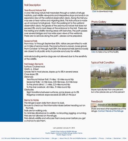
Cover   Contents   Summary     Primary    Secondary       Examples     More topics   Glossary   Resources

 Previous page                                                                              Next page

                             This is the second page of the preface.
                             Methodology - how did we develop these guidelines?
        Summary 2            The topic of disability can be overwhelming and intimidating,
                             even to people with disabilities, because the very nature of
                             disability is so diverse and the needs of the individual are so
                             personal.       Therefore, even though the Committee is
                             comprised both of people with disabilities and people who
                             are able-bodied, it determined that it was imperative to solicit
                             additional input to its proposed guidelines to validate or
                             challenge its conclusions and to gain further understanding in
                             how people use trails.

                             Proposed guidelines which had been developed by the
                             Committee were presented in a public forum and trail walk-
                             through on June 10, 2011 at the Tualatin River Wildlife Refuge.

                             A substantial number of comments was received which were
                             sorted into their respective topics and which suggested new
                             topics altogether.     By assimilating those comments, this
                             document is now the final draft version of those guidelines
                             and will be presented to public agencies and other non-profit
                             entities during two other forums to be held during 2012.

                             Comments from previous presentations
                             • Comments from June 10, 2011, and how they were sorted
                               into similar categories, can be viewed as a separate
                               webpage. [No longer available.]
                             • Comments from the May 10, 2012 presentation, can be
                               viewed as a separate webpage. [No longer available.]

                             Why did we choose this format for this document?
                             When this project was first considered, it was envisioned to
                             create a printed document - a book of guidelines. With the
                             prevalence of web-based publication and the realization that
                             most people who are blind or visually impaired now use
                             computers to read, the Committee opted to focus on a web-
                             based publication and one that is computer-reader aware.

                             This single-page format was chosen, so that anyone wishing to
                             print this document could do so on a conventional home
                             printer using Letter-size paper.

                             Need a five-minute, three-page tour of this document?
                             Just click Primary topics; Secondary topics; and More topics.

 ACCESS RECREATION GUIDELINES FOR COMMUNICATING TRAIL INFORMATION TO PEOPLE WITH DISABILITIES

 Previous page                              Page v of vii                                   Next page
Cover    Contents    Summary      Primary     Secondary       Examples       More topics   Glossary   Resources

  Previous page                                                                                   Next page

                                This is the third and final page of the preface.
                                How did we conserve resources?
                                All committee meetings were conducted without dependence
                                on paper by using a central display and web-based access to
                                meeting materials and by sharing of meeting minutes and
                                communications via the AccessRecreation.org website.

                                How are the pages organized?

Hidden text provides a brief
description of the page for
people using a computer
webpage reader

This area contains the
primary text from Guidelines
that were developed by the
Access Recreation
committee and augmented
by comments and input
from the June 10, 2011
workshop and site visit

This section contains
hypothetical text and
descriptions intended as an
example to be used on
future webpages and
printed materials

This section contains
additional insights into and
clarification about the topic
of the respective page

Photos are used for two
reasons: to help illustrate
the Guidelines text, and to
suggest illustrations that
could be used on future
webpages and printed
materials

  ACCESS RECREATION GUIDELINES FOR COMMUNICATING TRAIL INFORMATION TO PEOPLE WITH DISABILITIES

  Previous page                                 Page vi of vii                                    Next page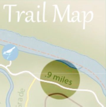
Cover   Contents   Summary     Primary    Secondary       Examples     More topics   Glossary   Resources

 Previous page                                                                              Next page

                             This is the fourth page of the summary.
                             Recent and upcoming presentations
        Summary 4
                             May 10, 2012
                             This document, in its Final Draft form, was presented at an event
                             held at the City of Portland on May 10, 2012. Whereas last-year’s
                             event of June 10, 2011 was directed primarily at people with
                             various types of disabilities, to determine if these Guidelines were
                             considered beneficial, the May 10 event was attended mostly
                             by representatives from various public agencies, at all levels of
                             government, and included a number of their web masters -
                             those responsible for creating agency websites and
                             disseminating public information.
                             We were pleased at how well received this document was at
                             the presentation. Conversely, many attendees were surprised at
                             how basic and simple the information was and offered that they
                             could easily adjust their current webpage content to
                             accommodate these recommendations at little or no cost.
                             We were reminded, yet again, to consider people with visual
                             impairments and not to focus solely on mobility impairments,
                             especially in the section on Ratings - an easy trail for wheelchair
                             users may be difficult for those with limited vision or vice versa.
                             Similarly, we were reminded that agencies need to clarify their
                             policies on the use of service animals - true all the more with
                             wilderness area trails where concern about safety of the service
                             animals and interacting with wildlife needs to be considered.
                             Finally, we reminded attendees that these Guidelines do not
                             propose to define the terms “ADA accessible” or “inaccessible”,
                             but to share information about trails and amenities so that trail
                             users can make their own informed decisions.
                             Additional presentations
                             • September 10, 2012: ORPA Annual Conference, Medford, OR
                             • October 26, 2012: WSTC 2012 Washington State Trails
                               Conference, Vancouver, WA
                             • November 2, 2012: Access Recreation is Celebrating
                               Completion of the Guidelines City of Portland, Portland, OR
                             • April 15, 2013: American Trails International Trails Symposium,
                               Fort McDowell Yavapai Nation, AZ
                             • May 4, 2013: Blinded Veterans Association, Newport, Oregon
                             • September 17, 2013: ORPA Annual Conference, Welches, OR

 ACCESS RECREATION GUIDELINES FOR COMMUNICATING TRAIL INFORMATION TO PEOPLE WITH DISABILITIES

 Previous page                              Page vii of vii                                 Next page
Cover   Contents   Summary     Primary    Secondary      Examples     More topics     Glossary     Resources

 Previous page                                                                                 Next page

                             This is a blank separator between the summary section and section1.

                                                                                     Section 1
                                                                            Primary Guidelines

 ACCESS RECREATION GUIDELINES FOR COMMUNICATING TRAIL INFORMATION TO PEOPLE WITH DISABILITIES

 Previous page                                                                                 Next page
Cover Contents Summary Primary Secondary Examples More topics Glossary Resources
Previous page Page 1 of 42 Next page
This page provides an overview of highest priority topics. Live links in the text take
one directly to each topic.
Section 1 Primary Information about trails – overview
This first part of the Guidelines identifies information that is
See Examples 1 and 2 for a considered minimal and mandatory for all information sharing
prototype webpage where whether on a webpage, on published materials or at the site
all these topics have been itself. This information is descriptive of the existing conditions and
assimilated. therefore is obtainable and can be applied without cost. The
categories described in greater detail include:
Contact information - whom does one contact to find out the
latest condition of the trail or recreational features; whom does
one contact to arrange for assistance; whom does one contact
in case of an emergency.
Location information - where is the trail or recreational feature;
where are parking and other amenities available; where are
Graphic 1 trailheads or points of arrival.
Basic location information
Considerations about the use of symbols on a webpage, on
starts with the point of arrival
published materials or on signage at the site itself, taking into
account that differences of color may not be suitable for all users.
A combination of color, shape and readily comprehensible
symbol design will provide the most universal application.
Graphic 2
An example of 3 accessible
A rating system that presents relative levels of difficulty and the
feature symbols degree of exertion that may be required, applicable primarily for
people with mobility impairments.
Identifying the amenities along a trail or recreational feature
that may be useful in deciding whether to pick a particular trail
or not, such as special views, benches or resting areas, *toilets, a
*visitor center and available water. *Built facilities such as toilets
and visitor centers need to conform to the ADA Accessibility
Guidelines, and in the case of visitors centers, should incorporate
the Smithsonian Guidelines for Accessible Exhibition Design.
Graphic 3
An example of a moderate A description of the overall trail itself as a continuous experience
to difficult wooded trail - a virtual tour - so that the potential user can decide whether to
pick a particular trail or not.
A discussion about specific design elements and constraints
such as typical and extreme slopes, cross slope and seasonal
obstacles in the path.
ACCESS RECREATION GUIDELINES FOR COMMUNICATING TRAIL INFORMATION TO PEOPLE WITH DISABILITIES
Previous page Page 1 of 42 Next pageCover Contents Summary Primary Secondary Examples More topics Glossary Resources
Previous page Page 2 of 42 Next page
Contact Information
Summary – It is essential to provide contact information – how to
reach the facility manager and staff and emergency phone
numbers – both on published materials and at appropriate
locations at the facility. These Guidelines place this requirement
first because it is so crucial to persons with a disability and yet it is
so easy to achieve.
Graphic 1
An example of contact Importance/Purpose – Users with disabilities have many ways of
information presented in the obtaining information, and what works for some may not work
upper lefthand corner of a for others. Therefore, information should be provided in a variety
document of formats to accommodate the greatest number of users
possible. Section 508 Standards, the federal standards for
accessible technology and website design, address many of
these needs, but an important example of what is not covered is
placement of contact information on a webpage. If that
information is located at the bottom of a very extensive
webpage a person using a reader will have difficulty finding it.
Location – Contact information should be provided at the top,
left-hand corner of webpages, and in a prominent location on
printed publications and trail signage. This information should
make clear how to contact the facility manager and/or staff for
additional information and to check for the latest conditions.
Another type of contact information essential to trail users is how
to reach emergency services if something were to occur along
the trail. Emergency contact information may be even more
important on trail signage than on published materials.
Contact information may already be provided but may be hard
to find, especially for web users with vision impairments using a
reader. Location is the key factor in satisfying this requirement,
making sure this information is easily accessible to all users. Users
with vision impairments need a way to get information such as
Braille. For information provided on site the use of new
technology may be helpful, such as the use of QR [quick
Graphic 2 response] codes to provide information directly to smart phones.
An example of trail signage
with QR code that can be Example
read by a smartphone • ‘For up-to-date facility and trail information, please contact...’
ACCESS RECREATION GUIDELINES FOR COMMUNICATING TRAIL INFORMATION TO PEOPLE WITH DISABILITIES
Previous page Page 2 of 42 Next pageCover Contents Summary Primary Secondary Examples More topics Glossary Resources
Previous page Page 3 of 42 Next page
Location
Summary – Provide locational and context information including:
facility address, the location of trailheads, parking facilities, and
public transportation routes.
Description – Describe the path of travel in its entirety, to and from
point-of-arrival to the facility, including information about
trailheads and restrooms at the site, and considering the various
ways a visitor might arrive at the site, such as pedestrian access,
Photo 1
The bus stop including bus
public transportation, and/or automobile.
number, in this case #12
Importance/Purpose – Information on facilities often does not
include a description of the relationship of the various parts of the
facility to one another. For users with disabilities this information is
essential to determine if the overall site is usable to them. For
example, if a restroom and the primary view area are not
connected by an accessible route, that information needs to be
provided. When describing location of facilities, one most often
assumes visitors will arrive by car. Many sites do offer pedestrian
access, so a description of that access is important. If users can
arrive at the site in other ways, a description of those alternatives
is also important.
Examples – If there is a drop-off area near a facility that
Photo 2 information is crucial to disabled users. If parking is provided, a
The sloped pathway from description of what kind of parking is available and what its
the bus stop to the entry relationship to the facilities at the overall site is important. Maps
can be a key way to satisfy this requirement, although they do
not work well for users with vision impairments.
The three images to the left present essential information about
Location and point-of-arrival. Other information might describe:
Parking Accommodations, for instance:
• There are two ADA accessible parking spaces available at the
Wildlife Center.
Public Transportation, for instance:
• Trimet bus #12 offers frequent service, and stops in front of the
facility on highway 99W. A 500 foot crushed rock path, with slopes
up to 5 percent, connects the bus stop with the Wildlife Center.
Graphic 3
Map showing point of
arrival and path to entry
ACCESS RECREATION GUIDELINES FOR COMMUNICATING TRAIL INFORMATION TO PEOPLE WITH DISABILITIES
Previous page Page 3 of 42 Next pageCover Contents Summary Primary Secondary Examples More topics Glossary Resources
Previous page Page 4 of 42 Next page
Symbols
Summary – Use international symbols as a simple way of
identifying the different amenities available at a site. Code
accessible facilities and trail features with a blue circle.
Graphic 1
The example above is all too Description – When providing information graphically the use of
common - amenity symbols, standard symbols, such as the NPS Standard Cartographic
without differentiation of
Symbols, can provide an easy way to communicate
shape or color to denote
accessibility information. By using both color and different
accessibility and without
descriptions.
shapes to denote accessible facilities, this information can easily
be added to existing maps.
Graphic 2 Importance/Purpose – Complex webpages often have
The example below uses accessibility information included, but it may be difficult to
color and shape to locate. By giving visual clues, such as shape and color, it is easy
differentiate accessible to focus on accessibility without compromising content. The use
features from those that are of color alone does not satisfy all purposes, as for people who
inaccessible and adds useful are color blind, so shape and color in combination is the key.
descriptions.
Examples – Converting a standard brown square restroom
symbol into a blue circular restroom symbol is an example of
how this can be readily achieved.
Parking at the Wildlife The examples to the left compare the common practice of using
Center is ADA compliant. one shape and color to denote amenities at a site, versus the
recommended practice of using both shape and color and to
Restrooms are ADA further explain the meaning of each symbol for each location.
compliant and located at Symbols that denote an accessible amenity should be clearly
the trailhead entrance and differentiated from those that denote inaccessible amenities.
inside the Wildlife Center.
Color provides an immediate cue, but a different shape is useful to
Picnic areas located at the people who are color blind. Pairing useful symbols with clear
trailhead adjacent to the descriptions of their specific location is also helpful. For example, not
restrooms are covered, every parking lot may be accessible to the same degree, even
with two accessible tables. though technically they are ADA compliant.
Although not a requirement, Use a key to differentiate the meaning of symbols, for instance:
these Guidelines propose
using blue circles to Accessible feature
designate accessible
features, which is becoming Non-accessible feature
universally accepted.
ACCESS RECREATION GUIDELINES FOR COMMUNICATING TRAIL INFORMATION TO PEOPLE WITH DISABILITIES
Previous page Page 4 of 42 Next pageCover Contents Summary Primary Secondary Examples More topics Glossary Resources
Previous page Page 5 of 42 Next page
Rating Systems - for people with mobility impairments
Summary – A rating system is an easy way to provide users with
mobility impairments a method to select a route that may be
safe and usable by them. [See People who are blind or have
visual impairments for insights into other forms of disability.]
Photo 1 Description – A rating system is determined by the primary
Easy - a shared flat bikeway elements that affect the ability to use a trail, including: type of
surface, grade, cross-slope, and distance between features.
Each rating is first defined using these base definitions, but may
need to be adjusted to reflect unusual conditions.
Examples of Rating Descriptions
• Easy – Hard/paved surface, minimum 5 feet wide, grades 5
percent or less, cross slopes 2 percent or less. Individuals using
mobility devices should be able to use this trail with little or no
assistance.
Photo 2 • Moderate – Hard/paved or compacted, crushed-rock surface,
Moderate - a paved path minimum 3 feet wide, grades 5 to 8 percent, cross slopes 2
but steep with handrail percent or less, with resting areas a maximum of every 200 feet.
Some individuals using mobility devices may require assistance.
• Difficult – Compacted, crushed-rock or natural surface,
minimum 3 feet wide, grades sustained at 8 to 10 percent,
cross slopes 3 percent or less, with resting areas a maximum of
every 100 feet. Constructed or natural barriers exist. Most
individuals using mobility devices may need assistance.
• Most difficult – Natural surface, 3 feet minimum wide path, no
resting areas, uneven rocky or natural barriers exist, sustained
grades 10 percent and greater, cross slopes 3 to 5 percent.
Moderate to difficult -
Most individuals using mobility devices will need assistance.
crushed rock but steep
Photo 4 Photo 5 Photo 6
Moderate to more difficult - Difficult - loose dirt and with rock Impossible - railroad tie steps
loose rock and steep obstruction
ACCESS RECREATION GUIDELINES FOR COMMUNICATING TRAIL INFORMATION TO PEOPLE WITH DISABILITIES
Previous page Page 5 of 42 Next pageCover Contents Summary Primary Secondary Examples More topics Glossary Resources
Previous page Page 6 of 42 Next page
Amenities at the outdoor facility
Summary – Briefly describe the availability and usability of facility
amenities, perhaps as a bulleted list, keeping in mind that, for
people with disabilities, most amenities are actually necessities.
Description – In describing the available amenities use
descriptors on location and accessibility. In addition, location
and travel distance to the available amenities can easily be
added to existing maps.
Importance/Purpose – Knowing about available amenities,
where they are located, the travel distance to and between
them will provide users with basic information about what is
Pictures 1 and 2 available at the park site and enabling them to make informed
decisions about whether the trails and site meet their needs.
Two good bench solutions
Examples – Amenities, starting from the highest priority, include:
• parking - where and how much; if none, indicate that, too
• restrooms - where; if none, indicate that, too
• drinking water - how reliable; if none, indicate that, too
• a visitor center - how accessible; if none, indicate that, too
• benches and resting areas - where and how accessible
• covered shelters and other structures - where
• open picnic areas - where and how accessible
• viewpoints - where and relative merit
Picture 3 • interpretive opportunities - what kind and relative merit
• availability of guides [human or printed] or published materials
A forlorn bench - unusable • other special services, such as mobility devices available to
and unused loan out, or shuttle transportation within the site
For people with disabilities most “amenities” are actually
“necessities”. Water may be crucial for all people, but for people
with disabilities it is essential to plan an excursion around the
availability of water, since dehydration is a constant danger. If no
water is available that is equally important to share.
If water is one prime concern, then, obviously, the availability and
reliability of restrooms, is the other prime need. Simply knowing that
Picture 4 a restroom is “accessible” may not be descriptive enough. Many
people with disabilities travel with attendants, suggesting that
A water fountain as reminder larger, private toilets might be more useful than toilet stalls.
of the need for water
ACCESS RECREATION GUIDELINES FOR COMMUNICATING TRAIL INFORMATION TO PEOPLE WITH DISABILITIES
Previous page Page 6 of 42 Next pageCover Contents Summary Primary Secondary Examples More topics Glossary Resources
Previous page Page 7 of 42 Next page
Below, a good example of Trail Description 1 – describing the experience of the trail
a trail description
Summary – Provide potential users with the information to help
Year-Round Nature Trail
them decide if a particular trail would meet their expectations.
A one-mile long nature
trail meanders through a Description – A description of the trail would start with the overall
variety of refuge habitats, experience, but include some physical descriptions such as trail
past wildlife viewpoints and surface, width and grade. Provide the trail length and distances
interpretive stops and ends between points of interest. Challenging aspects of the trail, points
in an expansive view at of interest and features such as places to rest and shaded areas
the wetland observation can be included in the description and located on a map.
deck.
Along the trail one may see Importance/Purpose – Providing a trail description that includes
or hear native and aspects of the trail experience as well as its physical condition
migrating birds. This trail allows users to make a more informed and safe decision as to
surface is made up of whether the experience would meet their individual expectations.
compacted small gravel. This knowledge is of great importance to those who use wheeled
devices and those with walking, visual or hearing impairments.
From the parking lot to the
wetland observation
deck, the grade of the
Examples
year-round nature trail • Describe the experience of what one might hear along the trail
does not exceed 5%, and is (useful for people with visual impairments) and other features one
steep only at the entrance will find (bridges, views, places to rest, water, wildlife, etc).
to the trail. • Highlight the most difficult aspects of the hiking trail in the
description and on maps.
There are five resting and • Describe obstacles and where they are located on the trail.
wildlife viewing areas with • Provide distances between features, to the trailhead and points
benches along the path.
of interest, including benches, shaded and covered areas,
The path passes over
viewpoints and interpretive displays along the trail.
several bridges and has
wide open views of the
• Provide details about other uses - dogs, horses, and multi-use.
wetlands. There are no • Indicate what interpretive opportunities are available and in
services along the path. what format.
A comprehensive overview of the
experience along the trail will help prepare
visitors of all abilities. Providing photos of
the trail, especially the challenging
sections, is an easy way to help inform
people.
Click on the sample photo albums to the
left, borrowed from the AccessTrails project,
to view a good method for displaying and
Audubon - Location and Arrival Champoeg - Trail characteristics describing photos on a webpage.
ACCESS RECREATION GUIDELINES FOR COMMUNICATING TRAIL INFORMATION TO PEOPLE WITH DISABILITIES
Page 7 of 42Cover Contents Summary Primary Secondary Examples More topics Glossary Resources
Previous page Page 8 of 42 Next page
Trail Description 2 – its physical characteristics
Summary – Now that a trail has been selected, provide users with
Trail description
information to help them plan better for its challenges.
Surface: Crushed rock
Description – Trail design elements include the surface, width,
Width: 6 - 8 feet grade, cross slope, obstacles and trail length. Surface can be
described in terms of hard (concrete, asphalt, wood),
Grade: flat in most places, compacted crushed rock or natural surface. When describing
slopes up to 5 percent in the grade and cross slope it is important to provide the average
several areas and maximum percentages. Provide distances to the most
significant trail features including locations of maximum grade,
Cross slope:Cover Contents Summary Primary Secondary Examples More topics Glossary Resources
Previous page Next page
This is a blank separator between section 1 and section 2.
Section 2
Secondary Guidelines
ACCESS RECREATION GUIDELINES FOR COMMUNICATING TRAIL INFORMATION TO PEOPLE WITH DISABILITIES
Previous page Next pageCover Contents Summary Primary Secondary Examples More topics Glossary Resources
Previous page Page 9 of 42 Next page
This page provides an overview of second priority topics. Live links in the text
take one directly to the topic.
Secondary Information about trails – overview
Section 2
See Examples 1 and 2 for a If the first part of the Guidelines provides information that is
prototype webpage where considered minimal and mandatory, then it follows that this second
all these topics have been part of the Guidelines proposes information that is considered
assimilated. additional and discretionary, and which can be assimilated when
opportunity and budget allow. The categories include:
Keeping information current and indicating to the prospective user
when that information was last updated. Get help to keep
information current by taking advantage of user feedback through
devices such as blogs and wikis.
The use of site photos and other illustrations that can augment
descriptive text and give the prospective trail user a better sense of
what may be experienced.
The creation of trail maps, both for online use and for possible
printing or for posting at trailheads. The development of interactive
or enhanced maps may add to the map experience by providing
features such as aerial photos, street views and other features that
may help better to understand basic map information. Those
features may be contributed live by trail users.
The incorporation of global positioning system [GPS] data to locate
specific points along the trail or at the recreational facility. The
inclusion of markers, such as distance markers, both located on
printed and web materials as well as along the trail itself, so that
users that have limitations - such as knowing how far an electric
wheelchair can travel on one charge - may plan better and
monitor their progress.
Considerations about how people who are blind or visually
impaired benefit from certain types of information. That topic leads
logically to issues of signage and wayfinding, which although
important for all users, is particularly of concern to those who have
visual impairments.
Considerations about how Operational and maintenance issues
can impact the quality and usability of a trail. And finally some
general Reminders about how to consider one’s role in this process.
ACCESS RECREATION GUIDELINES FOR COMMUNICATING TRAIL INFORMATION TO PEOPLE WITH DISABILITIES
Previous page Page 9 of 42 Next pageCover Contents Summary Primary Secondary Examples More topics Glossary Resources
Previous page Page 10 of 42 Next page
Use trail-user feedback to keep information current
Summary – Although it may be cost-prohibitive for agencies to
constantly visit and monitor their trail systems, it is essential to keep
information current and updated. Trail users can provide that
valuable information if there is a method of reporting back.
Description – Way too much information is posted on the internet
without indicating its date, undermining the credibility and
relevance of the information. Especially, for people with
disabilities, it is essential to understand the current condition of
published materials and the facilities themselves. To receive
Caption valuable information directly from the site, there is great potential
and benefit of receiving and assimilating user feedback from trail
users. Therefore, encourage feedback by installing comment
opportunities on the website.
Importance/Purpose – Updated and current information lets the
user know when the information was posted and whether that
information reflects current conditions. Current conditions could
be influenced by weather, natural disasters, or other unforeseen
influences that could impact or prevent usability, such as fallen
trees, flooding, ice and snow, and trail washout.
Examples
• Indicate when the publication or webpage was last updated or
signage was posted. The placement of this information, is less
crucial than contact information and therefore can be located
on published materials, at the discretion of the webpage
designer or the facility provider.
• Utilize community input through on-line feedback mechanisms
to provide user reviews: social networks, wikis, “Friends of” type
groups, etc.
• Link a website to other websites with more current conditions on
Graphics 1 and 2 trails or make this statement “for latest conditions contact ….”
The two linked images above • Link to accessibility information (“accessible programs, activities
are examples of how other and facilities" or it can say "trails" and have the international
trail users can provide live symbol of accessibility next to the ones that are accessible).
feedback on the condition of • When a site links to another, care should be taken to ensure the
trails and other insights quality of information remains true.
ACCESS RECREATION GUIDELINES FOR COMMUNICATING TRAIL INFORMATION TO PEOPLE WITH DISABILITIES
Previous page Page 10 of 42 Next pageCover Contents Summary Primary Secondary Examples More topics Glossary Resources
Previous page Page 11 of 42 Next page
Photos 1 through 6
Here we have attached 6
random photos that Site photos
demonstrate what site photos
might try to convey
Summary – Generic trail descriptions are not as beneficial to
people with disabilities as actual images of what can be
expected. As shown in the examples, the photos should depict
both the character and amenities of the trail and the worst-case
conditions, to help the potential user to determine if the trail is
suitable, or not.
Description – Site photos should reflect the overall character,
unique areas and the difficult sections of the trail. Site photos
need to be accompanied by a caption informing the user of
what is presented in the photo, otherwise computer reading
programs, for people who are blind, will simply call out “image”.
Importance/Purpose – Choosing the right photo can increase
public interest and use of the trail. Selecting photos that reflect
the character and unique features of the trail lets users know
what kind of experience they can expect. Photos depicting the
difficult sections of the trail will let users know if the trail is suitable
for their use. Marking locations on the trail map where the
photos were taken can also enhance interest in the trail.
Examples
• Photos of accessible features of the trail.
• Photos depicting overall character of the trail.
• Photos of the trailhead and destination.
• Photos of unique features of the trail.
• Photos highlighting difficult sections of the trail.
• Photos depicting accessibility concerns along the trail, such as
the transition from trail to bridge, will confirm for the user
whether the trail meets their ability levels.
ACCESS RECREATION GUIDELINES FOR COMMUNICATING TRAIL INFORMATION TO PEOPLE WITH DISABILITIES
Previous page Page 11 of 42 Next pageCover Contents Summary Primary Secondary Examples More topics Glossary Resources
Previous page Page 12 of 42 Next page
Trail maps
Summary – Trail maps, whether posted on the web, available as
printed materials, or available on site, are indispensable for
people with disabilities to better plan for, and anticipate the hike.
Description – Trail maps can be used to convey information in a
variety of ways. They can be used to pinpoint features, obstacles
and amenities along the trail. While maps generally provide a
Photo 1 visual reference, alternative formats, such as tactile maps should
The photo above shows a be considered; even then, mapping alone will not satisfy all users.
trail map, at a trail head, that
includes flora and fauna Importance/Purpose – The disabled community is made up of a
variety of sub-groups; each group receives and processes
information in different ways. It is important to show maps in a
variety of formats and provide enough information about the trail
to allow users to choose trails that meet their needs and abilities.
Providing access to trail maps/information along the trail as well
as at the trailhead gives users basic information as they are
experiencing the trail. Knowing potential challenges in advance
enables users to determine whether the trail meets their needs
and desired experience. Maps provide a way to convey to users
the distance between points, such as the trailhead and an
obstacle. Incorporating elevation changes or trail profiles into
the map is extremely useful.
Examples
• Accessible amenities such as restrooms, picnic areas, parking
lots and viewpoints can be indicated on a trail map with the
universal blue (accessible) symbol. Amenities should not be
considered accessible if they are not linked by an accessible
Graphic 2
route. The universal blue symbol would not be used in this case.
The example above is a part
• Distances between amenities or significant features should be
of a well-developed trail
map - click to see full map
indicated on a trail map.
• Trail elevation and degree of difficulty can be shown using a
variety of methods such as color coded trail segments,
elevation profiles or tactile maps.
• Color coding can be used effectively in mapping, but it should
Graphic 3 not be relied on as the only means of communicating
A trail profile may be as useful information, as some users, for instance, people who are color-
as the trail map itself blind, will not be able to differentiate the colors.
ACCESS RECREATION GUIDELINES FOR COMMUNICATING TRAIL INFORMATION TO PEOPLE WITH DISABILITIES
Previous page Page 12 of 42 Next pageCover Contents Summary Primary Secondary Examples More topics Glossary Resources
Previous page Page 13 of 42 Next page
Interactive or enhanced maps
Summary – For people with disabilities, interactive or enhanced
trail maps, that would be posted on line, may be even more
useful than regular trail maps, to better prepare for, and
anticipate the conditions of the hike. As a benefit, some
interactive maps are easier to prepare than conventional
maps and could save low-budget entities staff time and cost
and yet provide more useful and current resources.
Graphic 1 Description – Interactive or enhanced mapping can be
Example of GPS coordinates achieved through the utilization of online mapping resources,
for downtown Portland such as Google Maps and MapQuest, that provide a variety of
views which include street views and aerial photos. They also
can create custom-made trail maps by incorporating GPS or
smartphone tracking methods, by which the trail and its
specific features can be highlighted. User-contributed photos
and video can be added, and, if appropriate, even audio can
be inserted.
Graphic 2 Importance/Purpose – People planning hikes will often look at
Google map in aerial view websites for information. The type of information that can be
with user photo as a pop-up presented on websites is substantially more diverse and
interactive than printed material. In addition, the disabled
community may use one of several assistive devices that would
benefit from the use of mapping enhancements such as GPS
coordinates and smartphone tracking. Either way, the
additional perspective gained by the use of interactive maps
provides the user with another source of information about the
trail. Diversity is important since some users may find one type
of map easier to understand than another.
Examples
• An aerial view with interactive components may be more
beneficial to some users than a conventional trail map.
• Allowing users to contribute their comments and perspective
to maps can provide a way to update conditions and
Graphics 3 and 4 provide a variety of insights on the usability of a trail.
Enhanced maps showing • Mapping applications allow user contributed photos, videos
facility location [upper] and and descriptions of the trail experience.
trail as custom overlay [lower] • Mapping applications allow overlay of trails and features.
ACCESS RECREATION GUIDELINES FOR COMMUNICATING TRAIL INFORMATION TO PEOPLE WITH DISABILITIES
Previous page Page 13 of 42 Next pageCover Contents Summary Primary Secondary Examples More topics Glossary Resources
Previous page Page 14 of 42 Next page
Navigation using GPS or “smartphone” technology
Summary – In recent years, navigation systems, using GPS [global
positioning system], and more recently, “smartphone” technology,
have emerged as a reliable and inexpensive way for hikers to
determine their precise location. This is particularly useful to people
who enjoy outdoor recreation where more conventional
navigation, such as street names or building landmarks, would be
unavailable.
Graphic 1
A GPS device, such as this Description – Up to only a few years ago GPS was the best and only
Garmin, receives signals from way to determine one’s location. More recently with the rapid
up to 24 satellites and uses popularizaton of smartphone technology, such as the iPhone and
the data to establish a 3- iPad, another form of navigation has emerged that is even easier
dimensional position on earth to use, when it is available. Both types of navigation presuppose
access to their respective service: a GPS device needs to
communicate with at least four [of 24] satellites to obtain its
positioning data. Smartphone navigation requires access to a
cellphone data service. Therefore GPS may be more appropriate
for remote areas where cellphone data service is not available.
In more developed areas, with reliable cellphone data service,
GPS may be avoided, which is of benefit both to the trail map
producer and the hiker. Where GPS is the only option, coordinates
can be provided locating primary facilities, such as trailheads and
intersections, significant features, and amenities. This information
should be added to websites, printed materials and trail signage.
Importance/Purpose – More people are using navigational tools
such as GPS or smartphone technology. These are particularly
useful to people with visual impairments. At remote trails, adding
GPS coordinates to the trailhead and significant features or
amenities provides users with essential information.
Examples – apply to GPS locations, only
Graphic 2 and 3 • Provide GPS coordinates for beginning and end of a trail.
Devices, such as the iPad • Provide GPS coordinates for amenities such as restrooms, picnic
[upper] and iPhone [lower], areas, visitor center, water, etc.
receive signals from • Provide GPS coordinates to indicate where there are significant
cellphone data towers and features of the trail such as surface changes, changes to trail
require no coordinates width, stairs, steep grades, etc.
ACCESS RECREATION GUIDELINES FOR COMMUNICATING TRAIL INFORMATION TO PEOPLE WITH DISABILITIES
Previous page Page 14 of 42 Next pageCover Contents Summary Primary Secondary Examples More topics Glossary Resources
Previous page Page 15 of 42 Next page
Photos 1 through 3
Here we have attached 3
images that demonstrate Distance markers
trailside markers and how
they might be indicated on a
Summary – Knowing the total length of a trail, the distance to
trail map
crucial services, and being able to determine how far one has
come along a trail, are crucial information for people with
disabilities to participate in outdoor recreation.
Description – Providing information about where a person is on
the trail is essential to some users. Clear and legible distance
markers can indicate points along the trail and on trail maps.
When providing information on distance, markers are most
effective every quarter mile along the trail. Markers can be used
to designate trailheads, loops and dead-end trails.
They can be used also to indicate direction and distance to
parking, restrooms, picnic areas and other amenities. For
complex trail systems, providing maps at major trail junctions is
helpful. When markers are used along the trail, their location
should also be indicated on the trail map.
Importance/Purpose – Distance markers provide helpful
information for everyone, but especially for those who use
mobility devices and those with limited physical stamina. Well-
placed distance markers can help users determine how far they
can go on a trail before it is necessary to turn back to conserve
energy or to preserve battery life in mobility devices.
Distance is also a factor in the battery life of power wheelchairs.
Knowing the distance between the trailhead and segments of
the trail provides valuable information for power-chair users.
Examples
• Provide distances and distance markers both along trails and
published materials such as web-based and printed maps.
• Provide distances and distance markers every quarter mile.
• Provide distances and distance markers between significant
points such as parking, trailheads and features of the trail.
These distance markers show a diversity of height and style so that
they can integrate with the outdoor environment. It is important that
they are low enough to be seen by wheelchair users and that regular
maintenance prevents their becoming overgrown with vegetation.
ACCESS RECREATION GUIDELINES FOR COMMUNICATING TRAIL INFORMATION TO PEOPLE WITH DISABILITIES
Previous page Page 15 of 42 Next pageCover Contents Summary Primary Secondary Examples More topics Glossary Resources
Previous page Page 16 of 42 Next page
Signage and wayfinding
Wayfinding encompasses all Summary – Signage is useful to all trail users to provide essential
of the ways in which people information about distance, location and amenities; it is essential,
orient themselves in physical also, to all users to avoid getting lost in the outdoor environment.
space and navigate from For people with disabilities predictable signage is indispensable to
place to place. better monitor their hike and resource consumption and thereby
maintain their level of confidence.
Description – Trail signage comes in all kinds of types and levels of
sophistication, from the simplest color swatch on a tree to mark the
trail, to mileage markers, to informational kiosks at trail heads and
major intersections. It is useful for the potential hiker to understand
beforehand the quality of signage that can be expected and its
frequency. Ironically, too much signage may detract from the
outdoor experience and may dissuade a potential user from
choosing a particular site, therefore finding a balance is important.
Importance/Purpose – For a person with a disability to venture into
an outdoor environment requires a certain amount of knowledge
beforehand, as discussed under Trail Maps, to better plan for their
hike and to determine if a particular trail is of interest. Knowledge
about the quality and availability of signage will provide the user a
comfort level that they can succeed at their hike and safely.
Signage has many of the same concerns as the topic of Trail Maps:
don’t rely on color alone; wherever possible include a tactile
equivalent; make sure the information is low enough to be visible
with people in wheelchairs, but not so low that signs are readily
hidden by plant materials, snow or covered with mud.
Examples
• If using color coding to identify trails, provide trail numbers as well,
especially at intersections where two color-coded trails cross.
• On trail signs, don’t rely on color alone to identify the trail or
accessible features – use shapes, as well. See the Symbols page.
• Place signage along the trail low enough that it can be read by
people using mobility devices, for instance between 30” and 36”
for signage with text, but different heights for various markers.
• Indicate on the website if an audio guide or a smart phone app is
available and from where, to provide a possible substitute.
• See Section 3, More topics, for information about wayfinding.
ACCESS RECREATION GUIDELINES FOR COMMUNICATING TRAIL INFORMATION TO PEOPLE WITH DISABILITIES
Previous page Page 16 of 42 Next pageCover Contents Summary Primary Secondary Examples More topics Glossary Resources
Previous page Page 17 of 42 Next page
People who are blind or have limited sight
Summary – The predominance of accessibility guidelines is focused
on mobility impairments. Hikers who are blind will have different
concerns and needs from wheelchair users. Therefore, be
descriptive; describe trail features and their surroundings, especially
obstacles and hazards. Make graphic materials comprehensible.
Description – Hikers who are blind rely on various techniques to
orient themselves, generally referred to as wayfinding. Wayfinding
encompasses all of the ways in which people and animals orient
themselves in physical space and navigate from place to place.
For people who are blind, a common method of wayfinding relies
on using a “long cane” to locate the edge of a trail and to identify
Using a cane to negotiate a obstacles. Therefore, describing the quality of the path and
path and identify obstacles. identifying prominent landmarks is extremely beneficial. Other
considerations that may benefit the hiker who is blind, include
sensory experiences such as sound, shade or sun, and even smell.
People who are blind are quick to point out that they are good at
wayfinding – just remove the obstacles, we can figure out the rest...
– but anxious about obstacles that are outside the sweep zone of
the cane, and other hazards, such as twigs and branches.
Examples
• Consider implications of trail use for people with low vision or who
are blind. How does one find a trailhead or a major intersection?
• Explain what is the nature and condition of the trail edge and
Definition of edges is essential
what is done to maintain the edges.
for people who are blind.
• Explain what is the policy about service animals.
• What is the likelihood to find obstacles and/or branches that
hang over the path. What is done to prevent those problems?
• Provide information on the website and printed materials about
the availability [or lack] of tactile maps or audio descriptions.
• On published materials, don’t rely on color alone to identify
accessible features – use shapes, as well. See the Symbols page.
• Many people who are blind rely on reader programs on a
personal computer that are capable of reading text, but not
graphic images. When designing a webpage make sure that
graphics are identified with a caption or other explanation.
Branches across a path can • See Section 3, More topics, for information about wayfinding,
be hazardous. accessible website considerations and how a reader works.
ACCESS RECREATION GUIDELINES FOR COMMUNICATING TRAIL INFORMATION TO PEOPLE WITH DISABILITIES
Previous page Page 17 of 42 Next pageYou can also read