Quaternary geoarchaeology of South Asia - Oxford Abstracts
←
→
Page content transcription
If your browser does not render page correctly, please read the page content below
Quaternary geoarchaeology of South Asia
Terrestrial Processes, Deposits and History
Time: 9:00 - 10:45
Date: 27th July 2019
Location: Wicklow Meeting Room 1 (Level 2)

Posters will be on display on Saturday 27th July in Liffey Hall A and B and the
abstracts are available to download in the poster session for Saturday.

Chairperson: Nupur Tiwari

O-2064

Spatial distribution of Palaeolithic sites in relation to raw material
sources in the central Narmada valley, India

Vivek Singh
Indian Institute of Science Education & Research, Mohali, India

Abstract
The spatial distribution of archaeological sites in a particular area represents the land use
patterns of hominin population adaptations in accordance to raw material and water resources.
Understanding these distribution patterns also suggests their adaptations to different
conditions which provide insights on understanding their behaviour. Landscape adaptation in
central India is quite exceptional as more than 300 Lower Palaeolithic sites/occurrences have
been reported in different contexts. The present work specifically deals with these assemblages
and associated raw material sources in the central Narmada valley. The central Narmada valley
is rich in various rock types (sedimentary, metamorphic, igneous and volcanic) which also
served as raw material for various Pleistocene hominin populations. The Narmada River divides
the region into northern and southern parts. In the northern part of Narmada Valley, there are
mainly the Vindhyan Supergroup (sedimentary and metamorphic rocks) and Deccan Trap
(volcanic rocks), whereas in the southern part of Narmada Valley, there are mainly the
Gondwana Supergroup (sedimentary rocks), Deccan Trap and the Mahakoshal Group. Along the
river, there are a few exposures of the Vindhyan Supergroup and thick deposits of Quaternary
alluvium. Due to this varied geology, the quartzite and sandstone from the Vindhyan
Supergroup are prominently utilized, whereas, in the south of Narmada, the main raw materials
came from quartzite of the Mohakoshal Group in the form of pebbles, cobbles and boulders, and
chert from Gondwana Supergroup in the form of in situ exposures. Acheulean sites are mostly
found along the foothills of Vindhyans as well as along the banks of the Narmada River and its
tributaries. As pebbles and cobbles dominate the southern parts of the valley, the majority of
the Palaeolithic assemblages there comprise flake and chopper industries, which makes it
difficult to assign them to a particular lithic cultural phase. For now, no sites have been
reported or found on basalt (Deccan Trap) although stray artefacts have been observed. In this
paper, the author has tried to link these raw material sources with the occurrences of
Palaeolithic sites to have a better understanding of past hominin land use patterns and
ecological adaptations.
O-2065

Absence does not mean absence: Modern day land-use and the
visibility of the archaeological record (Kibbanahalli Palaeolithic
Complex, southern India)

Akash Srinivas
Department of Humanities and Social Sciences, Indian Institute of Science Education and
Research (IISER), Mohali, India

Abstract
Kibbanahalli is an important Lower Palaeolithic site-complex in southern Karnataka, a state in
the southern region of Peninsular India. This region is important as it is somewhat centrally
located between regions to the north, east and south, where decades of systematic Palaeolithic
research has led to the establishment of firm cultural stratigraphy(s), and even, in cases, of
chronology(s). However, in stark contrast to these regions, southern Karnataka is often ignored
in prehistoric research. Over 90 years of (intermittent) Palaeolithic investigations at this site-
complex have set the foundation of our understanding of the Palaeolithic occupation of this
vital region. It is of utmost importance to continue Palaeolithic research in this area as it is one
of the fastest industrialising and urbanising zones of the world, with large population centres
such as Bangalore (Bengaluru), Mysore (Mysuru) and others located here. Documenting the rich
Palaeolithic heritage in this region, before its eventual surrender to the forces of ‘development’
is thus a priority. Further, it is also necessary, if possible, to qualify and quantify the impact of
these developmental processes on the visibility and preservation of the archaeological record,
in general, and the Palaeolithic record, in particular, which might serve as a model for future
research in other similar regions. It is with this objective that the present author has initiated
field investigations into the rich Palaeolithic record of this region. These recent investigations
have led to a secure identification of the technological attribution of the lithic assemblages
here, as well as the identification of many new Palaeolithic localities. The presence of a uniform
stratigraphical association of the archaeological horizon and similarities in the lithic
assemblages have led to the reclassification of the many sites/localities at Kibbanahalli and its
vicinity, into a site-complex. This paper reports on a series of field observations and remotely-
sensed data collected to understand the distribution pattern of the various Palaeolithic localities
of this site-complex. Results of this study highlight the important role played by modern day
land-use patterns in the region on the observed distribution of the archaeological record as well
as on the visibility of the archaeological record itself. This challenges previous interpretations
regarding the settlement patterns and strategies suggested for the Palaeolithic occupation of
this region. Further, this study draws attention to the need and necessity to understand the role
of various site formation processes, especially modern day land-use activities, on the observed
and observable patterns in the archaeological record as well as the visibility, or lack thereof, of
the archaeological record.
O-2066

Stretching Boundaries: A geo-archaeological re-examination of
District Damoh and adjacent areas of Madhya Pradesh, from river
channels to peripheral landforms.

Yezad Pardiwalla
Indian Institute of Science Education and Research, Mohali, India

Abstract
Since the publication of R.V. Joshi’s work over half a century ago on the Palaeolithic record of
Damoh, this area of Madhya Pradesh in central India has received little interest compared to its
neighbours, the Narmada Basin in the south and the Son Valley to the northeast. This is not
surprising since a well-developed Quaternary stratigraphy is preserved along the Narmada and
Son. Though R.V. Joshi speaks about two tool-bearing gravel horizons and Sali (1990) puts forth
a general stratigraphy for the area, in comparison, the Sonar and Bearma, and their tributaries,
flowing through the district of Damoh and adjacent areas have far less extensive river sections
with Quaternary deposits, with the underlying Vindhyan bedrock exposed at regular intervals.
However this Vindhyan geology, made up primarily of shale and sandstone with quartzite
outcrops, and dominating the lithology of these basins, offers an opportunity to understand the
development of cultural surfaces/horizons, not limited to the outcome of fluvial processes. A
recent pilot survey in the area was undertaken with the objective to better understand the
landscape by expanding the focus to include the pediments and escarpments on the northwest
and east of the district while also surveying the various river and stream channels. Several
geomorphic processes including deposition by river action but also erosion, in-situ weathering
of bedrock and mass wasting seemed to have contributed uniquely to the distribution and
exposure of Palaeolithic sites across the region. The variety of available raw materials which
was seen to increase towards the fringes of the Sonar-Bearma basins warranted widening the
survey area to include parts of districts Panna and Satna, and the breccia formations of
Chhatarpur and understand any corresponding variability in lithic assemblages. By stretching
boundaries beyond fluvial environments, the most commonly worked upon archaeological
context in South Asian Palaeolithic studies, the present work aims to fill a lacuna in our
understanding of this potentially interesting study area straddled by some of the richest
prehistoric sites in the Indian subcontinent. Owing to the preliminary nature of the research
currently undertaken, no cultural or chronological categorisation of Palaeolithic sites from the
area has been attempted. However by revisiting localities mentioned in the published literature
and several previously unexplored ones, the various geomorphological processes and proximity
to a range of different fine quality raw material sources seem to have resulted in a rich
archaeological record spanning much of the Palaeolithic.
O-2067

Late Pleistocene palaeoenvironments in South Asia and associated
palaeoanthropological implications

Shashi Mehra, Parth Chauhan
Indian Institute of Science Education and Research, Mohali, India

Abstract
Climate change is prominently considered as a causal mechanism for hominin dispersals,
expansions and technological innovations/transitions in the Old World. Being in the centre of
the Old World and ecologically diverse, the Indian subcontinent must have played a prominent
role in hominin dispersals and adaptations across Asia during the Late Pleistocene. Despite
available palaeoenvironmental proxies and ample archaeological evidence, very few detailed
multidisciplinary studies have been carried out to investigate environment-human interactions
in prehistoric South Asia. This presentation focuses on the status of younger
palaeoenvironmental studies in South Asia and associated debates regarding hominin
behaviour and faunal extinctions. It synthesises current palaeoclimatic data and prehistoric
evidence at regional levels and proposes testable hypotheses regarding dispersal routes,
technological diversity (especially after ~100Ka) and associated adaptive strategies (e.g. Toba
issue, seasonal monsoon). Broad inferences are drawn from ~ 100 studies, carried out on
individual proxies including carbonates (7), sediments (34), pollen (16), ostrich eggshell
fragments (2), fossil enamel/wood/seed (4), speleothem (1) and multi-proxies (30). The records
show that the period from125 – 80 ka is predominantly characterised by humid environments. It
was followed by varied results/changes in climatic conditions at 79-70 ka and arid environments
at 69-60 ka. Between 59-30 ka, South Asia’s environment was again generally humid. The
period from 29-20 (LGM) again represent varied results which were later followed by the arid
conditions from 19-11 ka. Typo-technological transitions from the Middle Palaeolithic to the
early Mesolithic are also addressed, including interpretative issues with the Upper Palaeolithic.
Palaeoenvironmental reconstructions carried out thus far have lacunae regarding geographical,
temporal and methodological aspects. Finally, this paper highlights the importance of
investigating unexplored regions and focused time periods and attempts to link the South Asian
palaeoenvironmental records with regional Asian counterparts about hominin adaptations and
population movements.
O-2068

New techno-chronological data on select terminal Pleistocene-late
Holocene microlithic occurrences in the central Narmada basin,
Madhya Pradesh, India

Nupur Tiwari1, Morthekai P2, K Krishnan3, Parth R. Chauhan1
1Indian  Institute of Science Education and Research, Mohali, Punjab, India. 2Birbal Sahni
Institute of Palaeosciences, Lucknow, Uttar Pradesh, India. 3M. S. University of Baroda,
Vadodara, Gujarat , India

Abstract
The earliest occurrences of microliths in South Asia date back to the Late Pleistocene at
Mehtakheri in central India (48-45ka), Jwalapuram in southern India (38ka), Batadomba-Lena in
Sri Lanka (35-36 ka)and Kana and Mahadebbara in northeastern India (38-35 ka). Microlithic
technology is distributed almost across the entire Indian Subcontinent and chronologically
continues up to the Iron Age. This paper discusses new data acquired from the author’s ongoing
doctoral research in the two districts of central Narmada Basin, Madhya Pradesh (Hoshangabad
and Sehore) in central India.

The surveys were carried out in the Vindhyan and Gondwana foothills and in the surrounding
Narmada floodplains. Over 30 microlithic occurrences were identified and documented through
the four seasons of fieldwork (2015-2018). The assemblages were collected to study the
technological aspects of the microliths and locational data was recorded to understand land use
patterns. Few sites with abundant lithic assemblages in exposed sediments were selected for
optical dating, samples for which were processed between 2016-2018. We present here the
preliminary dates from key sites namely Pilikarar, Morpani, and Gurla-Sukkarwada. The dates
range between 12.4 ka and 2.2 ka. The luminescence measurements were carried out using
Risoe TL/OSL Reader at the Birbal Sahni Institute of Palaeosciences, Lucknow. The SAR (single
aliquot regeneration) protocol was applied to all the samples. The samples were processed
with basic chemical treatments to remove any substantial organic material and carbonates. The
fine-grained (4-11 mm) methodology was used to process the samples by preparing fifty
aliquots per sample. The ages were calculated from the DRAC using the central age model.

Technology during the terminal Pleistocene and early Holocene transitions from non-
geometrical to geometrical shapes, however, the assemblages are still being analysed for a
more comprehensive picture. The dates are varied between terminal Pleistocene to Holocene,
which can propose a change in the technology of the microlithic production. However, major
factors such as continuation of hunter-gatherer populations co-existing with the other
technologically developed populations by the proto-Historic and Historical periods cannot be
ruled out. This research confirms the existence of hunter-gatherer populations over a prolonged
time in the central Narmada basin since at least the late Pleistocene and possibly much earlier,
based on published data.
O-2069

Understanding Geo-archaeology in Trans-Himalaya: A Case study
based on Lithic assemblages from Dzamathang, Spiti Valley,
Himachal Pradesh, India

EKTA SINGH, Raman Patel, Pradeep Saklani
HNB Garhwal University, Srinagar Garhwal, India

Abstract
The Trans- Himalayan region is generally seen as a barrier during prehistoric times due to its
topographic and intense climatic features. Spiti Valley is located in the trans-Himalayan terrain
of India, from where non-geometric microliths, were recently discovered in this part of
Himalaya. While the Siwalik Hills have been subject to extensive prehistoric surveys, this is the
first evidence of lithic tools discovered in the trans-Himalayan region of Himachal Pradesh,
India. This suggests that this Himalayan zone may have also acted as a corridor instead of a
barrier during human migration. In fact, in the adjoining area of western Tibet, other
researchers have reported lithics from several sites and assigned to the Middle Palaeolithic. This
paper is based on artefacts which were collected from surface contexts. Large numbers of
lithics and debitage were found in the Dzamathang area of Spiti Valley. These assemblages
consist of assorted artefacts including a unifacial chopper, microlithic core, blade flakes, backed
blades, burins and a large amount of debitage. The majority of artefacts are on quartzite or
quartzarenite. The quartzite is the most common rock in the Spiti valley, from Neoproterozoic to
Permian age. The quartzite is mainly found in the Chandpur, Nagthat, Batal, Katarigali,
Chambaghat, Kauriyala formations (Neoproterozoic); Koti, Kunzam La formations (Cambrian);
Thango Formation (Ordovician); Muth quartzite Formation (Devonian) and Po Formation
(Carboniferous) in Spiti valley. The future surveys will be targeted at recovering primary context
sites for excavations and absolute dating.
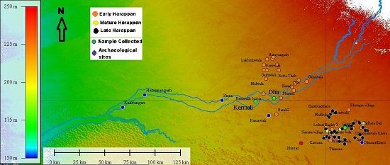
O-2070

A geo-archaeological study on mounds using multi proxy to
reconstruct past climate and drainage affecting Harappan
population near Rakhigarhi, India.

Apurva Alok1, Naresh. C. Pant1, Hari.S. Saini2, Yukiyasu Tsutsumi3, Kaushik Das4, Ravish Lal5
1University of Delhi, Delhi, India. 2Ex- director, Geological Survey of India, Noida, India. 3Natural
Museum of Nature and Sciences, Tokyo, Japan. 4Hiroshima University, Hiroshima, Japan. 5IISER ,
Mohali, India

Abstract
The age old of problem of the demise of Harappan Civilization, is conflicted because of
uncertainty related to the existence of a perennial river, also known as the Saraswati River. On
the basis of zircon dating, Clift et al. (2012), has suggested that the flow to the river was
perennial before 30ka and the river became ephemeral sometimes between around 30 and
15ka. Giosan (2012) observed that the absence of late Painted Grey Ware Harappan sites in the
lower reaches of the present day Ghagghar River (former Saraswati River), suggests that
Harappans moved out of the area due to lack of perennial source of water or due to weakening
of monsoon. However the migration of population, and the drainage disorganization of the river
(Clift et al. 2012) do not coincide. Few archaeological sites in Rakhigarhi, when observed from
the present proposed course of the river, lie very far away from any perennial river channel
(Singh et al. 2010), for any early civilization, hence Mehdi et al. (2016), on the basis of remote
sensing, identified two more tributaries which supported the presence of archaeological sites
away from the river.

Singh et al., 2010 and 2011, suggested the migration and expansion of Harappan population on
the basis of distribution of archaeological sites during different phases of Harappan timeline,
whereas Giosan et al. 2012, highlighted the role of climate and rainfall on the societal evolution
of the civilization. Numerous studies suggests that earlier river was perennial which turned
ephemeral before onset of Harappan Civilization (Singh et al. 2016)

Fig: Distribution of archaeological sites representing different phases of Harappan period.

However, our preliminary studies on sediments obtained from multiple archaeological mounds
near Rakhigarhi suggests a new story. Presence of burnt charcoal and ash collected from
different sedimentary layers within mounds suggests a series of occupation and abandonment
of these sites. C-14 ages of charcoal have helped in constraining these activities from early to
Mature Harappan phase. The presence of thick massive deposits of mud interlayered with ash
deposits suggests that during Harappan period, Rakhigarhi was in the vicinity of an active river
which frequently flooded the entire region forcing people to migrate. Similar studies have been
conducted on geological cum archaeological mound in the main paleochannel which also
represents age between early and late Harappan phases. At least three events of flood has
been recorded and have been analyzed. In this amalgamation of geology and archaeology, we
have attempted to create a relatively high resolution climate record and fluvial activities in the
region based on multiple proxies which affected the Harappan population to the extent that it
forced them to abandon these sites.
You can also read