RADAR REMOTE SENSING APPLICATIONS IN LANDSLIDE MONITORING WITH MULTI-PLATFORM INSAR OBSERVATIONS: A CASE STUDY FROM CHINA - ISPRS Archives
←
→
Page content transcription
If your browser does not render page correctly, please read the page content below
The International Archives of the Photogrammetry, Remote Sensing and Spatial Information Sciences, Volume XLII-2/W13, 2019
                              ISPRS Geospatial Week 2019, 10–14 June 2019, Enschede, The Netherlands

     RADAR REMOTE SENSING APPLICATIONS IN LANDSLIDE MONITORING WITH
       MULTI-PLATFORM INSAR OBSERVATIONS: A CASE STUDY FROM CHINA

                                      T. Qu 1, 2, Q. Xu2, C. Liu3, *, Z. Li 4, B. Chen 1, K. Dai 2
       1
        College of Engineering, Peking University, 100871 Beijing, China - (tengteng.qu, pkuchenbo, yangmk)@pku.edu.cn
 2
   State Key Laboratory of Geohazard Prevention and Geoenvironment Protection, Chengdu University of Technology, Chengdu
                                         610059, China – (xq, daikeren17)@cdut.edu.cn
         3
           College of Surveying and Geo-Informatics, Tongji University, Shanghai 200092, China - liuchun@tongji.edu.cn
 4
   COMET, School of Engineering, Newcastle University, Newcastle Upon Tyne NE1 7RU, UK - zhenhong.li@newcastle.ac.uk

                                                    Commission III, WG III/3

KEY WORDS: Radar Remote Sensing, InSAR, Multi-platform, TerraSAR-X, Sentinel-1, Landslide Monitoring

ABSTRACT:

In China, landslides are widely distributed in the mountainous areas of western regions. Especially after the Wenchuan
Earthquake in 2008, a large number of landslides were triggered. This work focuses on the deformation monitoring of Xishancun
Landslide based on multi-platform spaceborne radar remote sensing techniques. The spatio-temporal deformation characteristics
of landslide could be retrieved from time series InSAR processing with joint use of Sentinel-1 and TerraSAR-X datasets.
Eventually, the deformation and evolution histories are cultivated thoroughly to realize an effective and comprehensive
monitoring and research of Xishancun Landslide. This work concludes that spaceborne radar remote sensing applications could
demonstrate great potentials to identify the spatio-temporal characteristics and investigate the kinematics for hazardous
landslides, especially combined with in situ measurements and other remote sensing observations.

                     1. INTRODUCTION                                  research achievements have been demonstrated in landslide
                                                                      monitoring. In 2016, Dai et al. used Sentinel-1 images to
Landslide is one of the major and most frequently occurring           monitoring the activities of Daguangbao mega-landslide using
geo-hazards around the world. After the 2008 Wenchuan                 time series interferometry (Dai et al., 2016). In 2017, Barra et
Earthquake in China, a series of large-scale landslides were          al. used Sentinel-1 images and differential interferometry
triggered (Yin, 2009). Unexpectedness and concealed nature            technique to map and monitor the deformation activity in La
of the landslides significantly increase the destruction degree       Gomera, Tenerife and Gran Cananria islands (Barra et al.
and difficulty to prevent, exposing people’s livelihoods and          2017). Intrieri et al. used Sentinel-1 images for time series
infrastructure at risk (Huang et al., 2009; Liu et al., 2013).        InSAR processing to obtain the pre-disaster deformation of
                                                                      Maoxian Landslide in Sichuan, China (Intrieri et al., 2018).
The acquisition and long-term monitoring of surface                   Fiaschi et al. used Sentinel-1A datasets to detect and monitor
deformation information of large-scale landslides is an               landslides in the Veneto region of Italy (Fiaschi et al., 2017).
important basis for early warning and prediction of landslides        Czikhardt et al. used Sentinel-1 images and time series InSAR
(Xu et al., 2008). Especially, spaceborne radar remote sensing        technique to monitor ground stability in landslide-prone areas
could realize macro dynamic monitoring of large-scale                 of Slovenia (Czikhardt et al., 2017). In 2018, Kyriou et al.
landslide hazards and provide an efficient way to obtain              assessed the applicability of Sentinel-1 data in landslide
landslide     surface   deformation     and    spatio-temporal        mapping using three different processing methods, that is,
characteristics, hence contribute to early detection and early        interferogram map generation, DSM comparisons before and
warning for local disaster risk management (Ye et al., 2004;          after landslide, and offset tracking analysis (Kyriou and
Zhao et al., 2012).                                                   Nikolakopoulos, 2018). Liu et al. deployed Sentienl-1 datasets
                                                                      as well as other radar satellite observations for mutli-temporal
As an important part of ESA Copernicus program, ESA                   loess landslide inventory mapping (Liu et al., 2018).
launched Sentinel-1A on April 3, 2014 and Sentinel-1B on
April 16, 2016, opening a new era of radar satellite                  This work shares radar remote sensing applications in
observations. Sentinel-1 has a maximum resolution of 5                landslide monitoring case study in Sichuan Province of China
meters and a single-satellite re-visit cycle of 12 days, with         since 2014. Long deformation evolutions of landslide area
Sentinel-1B and Sentinel-1A in the same orbit (Torres et al.,         were retrieved from time series InSAR processing with joint
2012). Because of the precise orbital cube of Sentinel-1, the         use of multi-platform InSAR observations using TerraSAR-X
spatial baselines could be always kept within a certain range,        StripMap datasets and Sentinel-1A/B TOPS datasets.
which greatly improves the coherence of radar image
acquisitions, and provides an important support for landslide
monitoring and emergency response. Since its launch, many

* Corresponding author

                                                This contribution has been peer-reviewed.
                  https://doi.org/10.5194/isprs-archives-XLII-2-W13-1939-2019 | © Authors 2019. CC BY 4.0 License.              1939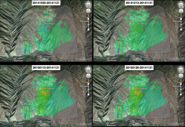
The International Archives of the Photogrammetry, Remote Sensing and Spatial Information Sciences, Volume XLII-2/W13, 2019
ISPRS Geospatial Week 2019, 10–14 June 2019, Enschede, The Netherlands
2. GEOLOGICAL SETTING OF XISHANCUN
LANDSLIDE
The Xishancun Landslide (Figure 1) is located in Li County,
Sichuan Province, southwest of China and only 20km away
from Wenchuan County. This large-scale landslide is seriously
affected by the “5.12” Wenchuan Earthquake in 2008. Its rear
edge is bounded by near-vertical cliffs, and the front edge of
the landslide is bounded by Zagunaohe River. There are
gullies on both sides of the landslide. The plane shape of the
landslide body is generally circular chair-like, with the leading
edge elevation of 1510m, the trailing edge elevation of 3300m
and the height difference of 1790m. The length of landslide is
about 3800m, the minimum width is 680m and the maximum
is 980m. The average thickness of the sliding body is 55m,
and the scale of the sliding body is 1.7×10⁸m³.
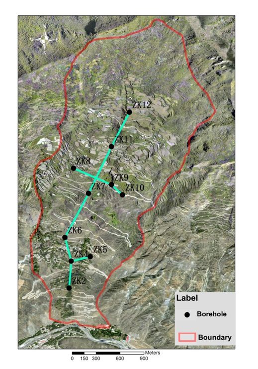
Figure 2. Spatial distributions of diverse boreholes on
Xishancun Landslide
Figure 1. The overview of Xishancun Landslide 3. MULTI-PLATFORM TIME SERIES INSAR
PROCESSING
The whole vegetation in the landslide area is scarce, with a
typical arid landscape.The middle and lower parts of the In this study, TerraSAR-X StripMap descending datasets
landslide are rich in water catchment and domestic water, acquired from Oct. 2014 to April. 2015 and Sentinel-1A/B
groundwater is relatively rich, vegetation is developed, fruit TOPS descending datasets acquired from Oct. 2014 to Feb.
trees are numerous, and crops are flourishing. Due to the 2017 are utilized for Time Series InSAR processing. As
construction of mountain-village highway, the cutting slope at mountainous western China has undulating terrains and
the foot of the front slope of the landslide is serious, which abundant water vapor on valley slopes, which resulted in the
has formed a steep slope of 3-15m, and part of the area has severe problems of atmospheric disturbance in time series
collapsed. The complexity of topographic conditions and slope InSAR processing, TSInSAR-AEM method (Li et al., 2009)
gradient are the main factors controlling the occurrence of proposed by Zhenhong Li is deployed with integration of
geological hazards, which are further deteriorated under the atmospheric phase estimation, which accurately separated the
damage of the "5.12" Wenchuan earthquake. A Spatial Sensor atmospheric disturbance and improved the reliability of time
Network (Figure 2) is also deployed on Xishancun Landslide series deformation results.
with multiple boreholes and in-situ sensors since 2014 (Qu et
al., 2016; Liu et al., 2018). Sentinel-1 uses the most advanced precise orbit determination
technology, and its orbit accuracy is more precise than any
previous radar satellite. It can be seen from Figure 3 that the
perpendicular baselines of Sentinel-1 interferometric pairs are
significantly shorter than those of TerraSAR-X pairs. The
longest Sentinel-1 baseline is 212 meters, while the
interferometric pairs with baselines under 100 meters account
for 80%. Short baseline greatly guarantees the coherence
quality of interferometric pairs, and provides a reliable data
basis for subsequent differential processing.
Figure 3. Spatial (vertical axis) and temporal (horizontal axis)
baselines of TerraSAR-X (a) and Sentinel-1 (b) datasets
during the TSInSAR-AEM processing
This contribution has been peer-reviewed.
https://doi.org/10.5194/isprs-archives-XLII-2-W13-1939-2019 | © Authors 2019. CC BY 4.0 License. 1940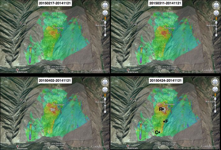
The International Archives of the Photogrammetry, Remote Sensing and Spatial Information Sciences, Volume XLII-2/W13, 2019
ISPRS Geospatial Week 2019, 10–14 June 2019, Enschede, The Netherlands
The displacement rate maps computed using TerraSAR-X
datasets is demonstrated in image a of Figure 4. The middle
part of the landslide accounted for largest deformation with a
rate of 13.2cm/yr. The eastern boundary of the deformation
slope is quite clear with the displacement rate being 10cm/yr.
The upper part of the slope is relatively stable, with no
obvious deformation signals. The lower part of the slope
deformed significantly with a rate of 8cm/yr. A small region
quite close to the river bank demonstrated a displacement rate
of 11cm/yr.
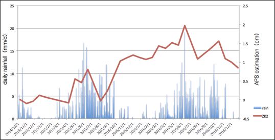
Figure 5. The relationship of rainfall and accumulative
The displacement rate map computed using Sentinel-1
descending datasets is demonstrated in image b of Figure 4. atmospheric phase corrections achieved by time series
As a whole, the deformation patterns of Xishancun landslide processing on Borehole ZK2
using Sentinel-1 datasets are quite similar to the patterns
acquired from TerraSAR-X processing. However, the overall The radar images acquired during the rainy season will cause
displacement rate is relatively lower than the result shown serious atmospheric artifacts, while the contribution of the
above. The largest deformation area is still the middle part of atmospheric phase screen for the radar images acquired during
the slope, with a rate of 12.4cm/yr. The eastern boundary of the dry seasons is relatively small. Therefore, the application
the deformation slope shows a displacement rate being 8cm/yr. of space-borne radar remote sensing in landslide deformation
The lower part of the landslide demonstrated a creeping monitoring needs to focus on the estimation and removal of
displacement rate of only 4cm/yr. atmospheric artifacts. The TSInSAR-AEM model used in this
paper effectively avoids introducing atmospheric artefacts into
time series deformation signals, thus facilitating the
interpretation and analysis of the final deformation evolution
results.
4. TIME SERIES EVOLUTIONS OF XISHANCUN
LANDSLIDE ACQUIRED FROM MULTI-PLATFORM
OBSERVATIONS
Figure 6 and Figure 7 shows the time series deformation
evolutions of Xishancun landslide using TerraSAR-X and
Sentinel-1 datasets since 2014. Especially, as Sentinel-1
datasets cover a long time span, the evolution of Xishancun
Landslide has been fully demonstrated.
Figure 4. Deformation displacement rate maps derived from
TerraSAR-X (a) and Sentinel-1 (b) datasets
Disparities between TerraSAR-X and Sentinel-1 time series
results could be caused by: 1) Limited time span for
TerraSAR-X results in its overestimate of annual velocity. 2)
Different temporal samplings. 3) Different observation
geometries. 4) DEM-induced uncertainties.
Daily rainfall data from 2014 to 2016 can be obtained due to
the installation of rainfall gauges on landslides. In order to
evaluate the reliability of the atmospheric phase estimation
results, it is necessary to analyze the influence of the
atmospheric phase screen on the deformation monitoring
results of Xishancun Landslide. As Xishancun Landslide is
near Zagunao River and located in the mountainous area with
large relief, the phase delay caused by the atmospheric phase
screen is very significant. Figure 5 shows the cumulative
atmospheric phase correction of ZK2, the borehole closest to
Zagunao River in the front of landslide body. It can be seen
from the chart that the time series atmospheric phase
corrections of ZK2 and daily rainfall produce almost
synchronous trough peaks during the flood seasons in 2015
and 2016, hence it can be inferred that the atmospheric phase
values and rainfall have a high correlation.
This contribution has been peer-reviewed.
https://doi.org/10.5194/isprs-archives-XLII-2-W13-1939-2019 | © Authors 2019. CC BY 4.0 License. 1941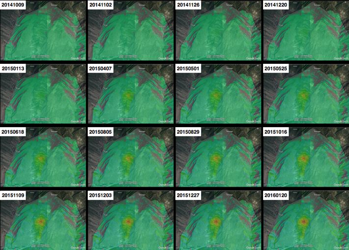
The International Archives of the Photogrammetry, Remote Sensing and Spatial Information Sciences, Volume XLII-2/W13, 2019
ISPRS Geospatial Week 2019, 10–14 June 2019, Enschede, The Netherlands
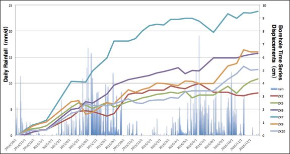
monitoring time series on Borehole 2, 5, 6, 7, 9 and 10. It can
be seen from the image that the rainfall of Xishancun
Landslide region is large from June to October every year,
which is basically consistent with local weather forecast.
Borehole surface time series displacements showed to be
gentle and approximately linear trend in dry seasons, however
became fluctuating and accelerating in rainy seasons. The
deformation acceleration trend of most boreholes influenced
by seasonal rainfall has an obvious hysteresis effect.
Figure 6. Time series evolutions of Xishancun Landslide
acquired from TerraSAR-X datasets
From the time series results from multi-platform radar
observations, it can be concluded that the middle and eastern
parts of the landslide body deformed for two and a half years,
but the overall deformation range did not expand significantly.
The front edge and rear edge of the landslide body did not Figure 8. Borehole time series displacements against the daily
have obvious deformations, and the whole landslide was still rainfall measurements
in the creeping stage.
5. CONCLUSIONS
To fully investigate and validate the great potential of
Sentinel-1 on landslide monitoring in complex terrain
mountainous areas, and integrate the radar datasets from
Sentinel-1 and TerraSAR-X, this work realized the landslide
surface deformation acquisition with multi scales, short time
intervals, and long time series, which also verify the great
advantage of multi-platform spaceborne radar remote sensing
on landslide monitoring. Combined with in situ measurements,
landslide spatial temporal evolutions are further cultivated.
This work concludes that spaceborne radar remote sensing
applications could demonstrate great potentials to monitor
landslide deformations, identify the spatio-temporal
characteristics and recognize landslide kinematics.
ACKNOWLEDGEMENTS
This work was supported by the 973 National Basic Research
Program (No. 2013CB733204), National Key R&D Program
of China (No. 2018YFB0505300), Opening fund of State Key
Laboratory of Geohazard Prevention and Geoenvironment
Protection (Chengdu University of Technology)
(SKLGP2019K022) and supported by State Key Laboratory of
Geodesy and Earth’s Dynamics (Institute of Geodesy and
Geophysics, CAS) (SKLGED2019-5-1-E). The TerraSAR-X
Stripmap datasets are copyrighted by DLR/Infoterra GmbH.
The Sentinel-1 datasets are copyrighted by ESA. Some
geocoded maps were generated by the General Mapping Tools
(GMT).
REFERENCES
Figure 7. Time series evolutions of Xishancun Landslide
acquired from Sentinel-1 datasets Barra, A.; Monserrat, O.; Crosetto, M., et al., 2017. In
Sentinel-1 data analysis for landslide detection and mapping:
In order to analyze the relationships between deformation First experiences in italy and spain, Workshop on World
evolution of borehole and rainfall, Figure 8 overlaps the data Landslide Forum; Springer: pp 201-208.
of daily rainfall measured by rain gauges with Sentinel-1
This contribution has been peer-reviewed.
https://doi.org/10.5194/isprs-archives-XLII-2-W13-1939-2019 | © Authors 2019. CC BY 4.0 License. 1942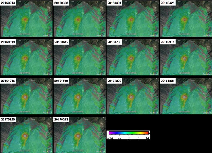
The International Archives of the Photogrammetry, Remote Sensing and Spatial Information Sciences, Volume XLII-2/W13, 2019
                            ISPRS Geospatial Week 2019, 10–14 June 2019, Enschede, The Netherlands

Czikhardt, R.; Papco, J.; Bakon, M., et al., 2017. Ground          Yin, Y., 2009. Features of landslides triggered by the
stability monitoring of undermined and landslide prone areas       wenchuan earthquake. Journal of Engineering Geology, 1, 29-
by means of sentinel-1 multi-temporal insar, case study from       38.
slovakia. Geosciences, 7, 87.
                                                                   Zhao, C.; Lu, Z.; Zhang, Q.; de La Fuente, J., 2012. Large-
Dai, K.; Li, Z.; Tomás, R., et al., 2016. Monitoring activity at   area landslide detection and monitoring with ALOS/PALSAR
the daguangbao mega-landslide (china) using sentinel-1 tops        imagery data over Northern California and Southern Oregon,
time series interferometry. Remote Sensing of Environment,         USA. Remote Sens. Environ., 124, 348–359.
186, 501-513.

Fiaschi, S.; Mantovani, M.; Frigerio, S., et al., 2017. Testing
the potential of sentinel-1a tops interferometry for the
detection and monitoring of landslides at local scale (veneto
region, italy). Environmental Earth Sciences, 76, 492.

Huang, R.; Li, W.L., 2009. Analysis of the geo-hazards
triggered by the 12 May 2008 Wenchuan Earthquake, China.
Bull. Eng. Geol. Environ., 68, 363–371.

Intrieri, E.; Raspini, F.; Fumagalli, A., et al., 2018. The
maoxian landslide as seen from space: Detecting precursors of
failure with sentinel-1 data. Landslides, 15, 123-133.

Kyriou, A.; Nikolakopoulos, K., 2018. Assessing the
suitability of sentinel-1 data for landslide mapping. European
Journal of Remote Sensing, 51, 402-411.

Li, Z.; Fielding, E.J.; Cross, P., 2009. Integration of insar
time-series analysis and water-vapor correction for mapping
postseismic motion after the 2003 bam (iran) earthquake.
IEEE Transactions on Geoscience and Remote Sensing, 47,
3220-3230.

Liu, C.; Li, W.; Wu, H.; Lu, P.; Sang, K.; Sun, W.; Chen, W.;
Hong, Y.; Li, R., 2013. Susceptibility evaluation and mapping
of China’s landslides based on multi-source data. Nat. Hazards,
69, 1477–1495.

Liu C, Shao X, Wu H, et al., 2018. Giant landslide
displacement analysis using a point cloud set conflict
technique: a case in Xishancun landslide, Sichuan, China.
International Journal of Remote Sensing: 1-20.

Liu X, Zhao C, Zhang Q, et al., 2018. Multi-Temporal Loess
Landslide Inventory Mapping with C-, X-and L-Band SAR
Datasets—A Case Study of Heifangtai Loess Landslides,
China. Remote Sensing, 10(11): 1756.

Qu, T.; Lu, P.; Liu, C., et al., 2016. Hybrid-sar technique:
Joint analysis using phase-based and amplitude-based methods
for the xishancun giant landslide monitoring. Remote Sensing,
8, 874.

Torres, R.; Snoeij, P.; Geudtner, D., et al., 2012. Gmes
sentinel-1 mission. Remote Sensing of Environment, 120, 9-
24.

Xu, Q.; Tang, M.; Xu, K., et al., 2008. Research on space-time
evolution laws and early warning-prediction of landslides.
Chinese Journal of Rock Mechanics and Engineering, 6, 005.

Ye, X.; Kaufmann, H.; Guo, X., 2004. Landslide monitoring
in the Three Gorges area using D-InSAR and corner reflectors.
Photogram. Eng. Remote Sens., 70, 1167–1172.

                                               This contribution has been peer-reviewed.
                 https://doi.org/10.5194/isprs-archives-XLII-2-W13-1939-2019 | © Authors 2019. CC BY 4.0 License.          1943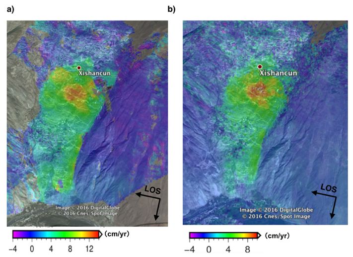
You can also read