Received June 1 2020 Town of Erin Building & Planning Dept.
←
→
Page content transcription
If your browser does not render page correctly, please read the page content below
OPA 11
June 1 2020                June 1 2020
                            5-06802
x                          June 30 2020
                           5-06802

                   Received
                  June 1 2020
              _________________
              Town of Erin Building
                & Planning Dept.
RECEIVED
    TOWN OF ERIN
     Jun 01, 2020
BUILDING DEPARTMENT
PEOPLE | ENGINEERING | ENVIRONMENTS
RECEIVED
June 19, 2020 TOWN OF ERIN
Our File: 120062
Jun 19, 2020
BUILDING DEPARTMENT
JL Cox Planning Consultants Inc.
ATTN: John Cox
17 Spencer Crescent
Guelph ON N1L 1N1
Via E-mail
Re: Preliminary Hydrogeological Feasibility
Assessment for Private Servicing of Lot
Severance: Part 1, 61R-20684, Town of Erin
Dear Mr. Cox,
GM BluePlan Engineering Limited (GMBP) have been retained by JL Cox Planning Consultants Inc. (the “Client”) to
provide hydrogeological services to support the arrangement of municipal approvals for a potential rural residential lot
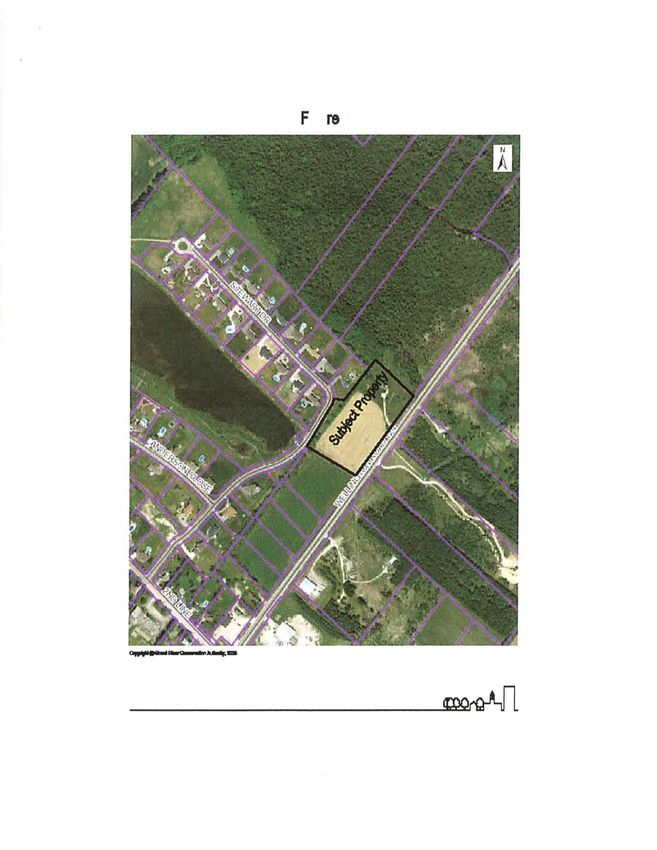
severance in the Town of Erin. The lands under consideration (i.e. the “Site”) are located on the north side of Wellington
Country Road 124, approximately 500 m northwest of Ospringe corner. It is further defined as part of Lot 13, Concession
3, Geographic Township of Erin, and Part 1 of Plan 61R-20684. It bears property index number 71148-0425(LT).
The proposed severance of the Site will ultimately result in four lots on the lands under consideration, each sized as
follows:
• Severed Lot 1: 0.59 ha
• Severed Lot 2: 0.52 ha
• Severed Lot 3: 0.54 ha
• Retained Lot: 1.27 ha (which hosts the existing residence on-Site).
This preliminary hydrogeological feasibility assessment is intended to establish whether it will be feasible to develop this
lot for residential use (i.e. detached house) with private servicing as described above.
GEOLOGICAL SETTING
Physiographic mapping indicates that the Site lies upon a spillway landform (2007b). These landforms originated from
the rapid flow of glacial meltwater eroding the landscape and are usually characterized by low-lying lands and gravelly-
sandy soil materials.
According to map sets available from the Ontario Ministry of Northern Development and Mines (2006, 2007a), the
geological materials underlying the Site are briefly summarized as follows:
• Wentworth Till (silty-sandy texture) overlying
• Gasport Formation (dolostone) bedrock.
Nearby water well records indicate that the depth to bedrock is in the range of 4.3 to 13.5 m below ground surface.
GUELPH | OW EN SOUND | LISTOWEL | KITCHENER | LONDON | HAMILTON | GTA
650 W OODLAW N RD. W ., BLOCK C, UNIT 2, GUELPH ON N1K 1B8 P: 519-824-8150 F: 519-824-8089 WWW.GMBLUEPLAN.CAPAGE 2 OF 5
OUR FILE: 120062
The Wentworth Till that makes up the surficial materials are generally relatively dense and of fine texture (i.e. high
proportion of silt) and as a result tend to have low hydraulic conductivity. A well record attributed to the Site (Well ID
6703459) indicates a layer of sand and gravel 2.1-m thick at surface, underlain by “light grey clay” (i.e. till). It is expected
that the surficial sand and gravel material becomes more prevalent with proximity to Eramosa River.
The Site is located approximately 500 m southwest of the location where Wellington County Road 124 crosses the
Eramosa River. Based on topographic mapping, it appears that there is a topographic divide running that separates the
northeastern quarter of the Site from the southwestern three-quarters of the Site (GRCA 2019). The larger part of the
Site drains southwestward toward a tributary of the Eramosa River that passes along the southwestern Site boundary,
while the smaller northeastern part appears to drain more directly toward the Eramosa River via the roadway ditches or
via the associated wetland area that lies just beyond the northeastern property line (GRCA 2020).
Groundwater levels on the Site may vary due to the apparent variability of the surficial materials. Where till materials are
found at surface, groundwater levels may rise near the surface in the winter and spring. However, given the fairly steep
slope and the presence of coarse surficial materials to the northeast of the Site, it may be that water levels in that part of
the Site remain somewhat deeper due to the improved drainage provided by these conditions.
SERVICING CONSIDERATIONS
On-Site Sewage Systems
The primary concern related to on-site sewage systems for residential development is the effect that these systems may
have on the concentration of nitrate in local groundwater. The proposed development must ensure that its sewage
management does not negatively impact groundwater quality and preclude its use for other purposes or by other (i.e.
off-site) users. The most prevalent use for groundwater use is domestic consumption and so typically this means that a
given development must not result in nitrate concentrations of 10 mg/L (per Ontario Drinking Water Standards) in the
groundwater going off-Site.
Due to the size of the proposed lots, the potential for nitrate impacts due to sewage usage are expected to be low.
Nitrogen attenuation calculations for the proposed development have been computed as per the method given in MOE
Procedure D-5-4 (1996) and are summarized in Table 1.
Table 1: Nitrogen Attenuation Calculations for Small Lot Created by Severance
Line Item Value Source
1 Average Annual Precipitation (mm/yr) 798 Environment Canada (Shand Dam)
2 Average Annual Evapotransporation (mm/yr) 550 MNR (1984)
3 Runoff Coefficient 0.25 Estimated, typical for rural residential usage
4 Estimated Recharge Rate (mm/yr) 186 (Line 1 – Line 2) * (1 – Line 3)
5 Site Area (m2) 29,200 From Conceptual Plan (see Enclosure A)
6 Hydrologic Input (L/yr) 5,431,000 Line 4 * Line 5, units converted
7 Number of Lots 4 From Conceptual Plan (see Enclosure A)
8 Sewage Effluent Input Rate (L/lot/day) 1,000 Specified by Procedure D-5-4
9 Annual Sewage Effluent Input (L/yr) 1,460,000 Line 7 * Line 8, units converted
10 Total Water Input (L/yr) 6,891,000 Line 6 + Line 9, units converted
11 Nitrate Output (g/lot/day) 40 Specified by Procedure D-5-4
12 Annual Nitrogen Loading (g/yr) 58,400 Line 7 * Line 11, units converted
13 Attenuated Nitrate Concentration (mg/L) 8.5 Line 12 / Line 10, units converted
GUELPH | OW EN SOUND | LISTOWEL | KITCHENER | LONDON | HAMILTON | GTAPAGE 3 OF 5
OUR FILE: 120062
The attenuated nitrate concentration for the Site is estimated to be 8.5 mg/L, which is less than the maximum allowable
10 mg/L. As such, it is anticipated that the Site will be sufficiently serviced using conventional Class 4 sewage systems
per the Ontario Building Code (i.e. septic tank and tile bed).
Due to the potential for high seasonal groundwater levels, the leaching bed for the on-site sewage system may need to
be a raised or “fill-based” bed in order to comply with Ontario Building Code requirements for separation from the
groundwater table. A detailed soil survey (ideally conducted in February, March or April) or seasonal groundwater
monitoring program may be used to identify seasonal high groundwater levels for the proposed new leaching bed.
Assuming the tile bed is constructed as fill-based absorption trenches serving a 5-bedroom dwelling and is raised 0.5 m
above the surrounding ground (assuming level ground), the size of the bed will be approximately 34 m by 37 m. The
smallest dimension of any of the Sites is 40 m in width, and so it is anticipated that there will be adequate space available
to construct a tile bed for the on-site sewage system.
Private Well and Water Supply
The local Gasport Formation (bedrock) aquifer has been well-studied and is understood to generally be a reliable source
of groundwater for domestic consumption. The local overburden is a silty-sandy till and is not recommended for use as
a source of water for domestic consumption. Though sand and gravel materials may be found in parts of the Site and
though those materials may in some cases be shown to provide adequate water supply to support domestic usage,
shallow overburden wells are more susceptible to groundwater impacts. It is therefore recommended that groundwater
supply wells be installed in the bedrock aquifer.
According to nearby water well records, the subcrop of the Gasport Formation may lie between 4 and 14 m below ground
surface. This formation typically has high transmissivity and so is usually highly capable of meeting typical domestic
demands for water supply. The water quality from the Gasport Formation generally meets the Ontario Drinking Water
Standards, with the exception of certain aesthetic parameters such as hardness. Due to the relatively thin layer of
overburden in this area, it is recommended that the water wells be installed such that the annular seal and watertight
casing extend from ground surface to bedrock or to a depth of 6 m, whichever is greatest, to provide increased protection
from water quality impacts from surface activities.
It is recommended that the new water wells be installed (in respect of the separation requirements set forth in the Ontario
Building Code) at least 15 m away from existing or proposed sewage treatment systems, including those on neighbouring
properties.
This preliminary assessment has not included review of the condition, type of construction, supply or water quality of any
existing well on-Site.
CONCLUSION
A preliminary hydrogeological assessment of a proposed lot severance for a 2.92-ha Site located within Lot 13,
Concession 3, Geographic Township of Erin, has been conducted to assess the feasibility for the Site to support four
residential lots, each serviced by private water wells and private on-site sewage.
The findings of the assessment indicate that:
• on-site sewage systems would be sufficient to provide sewage servicing for the proposed development;
• on-site sewage systems may be conventional Class 4 systems (i.e. septic tank and tile bed);
• the tile bed may need to be constructed as a raised bed depending on the soils and groundwater elevations;
• sufficient groundwater supply is likely available from the bedrock (Gasport Formation) aquifer below the Site;
• the hydrogeological conditions generally support the proposed and servicing scheme; and
• the proposed severance is feasible from a hydrogeological perspective.
GUELPH | OW EN SOUND | LISTOWEL | KITCHENER | LONDON | HAMILTON | GTAPAGE 4 OF 5
OUR FILE: 120062
It is further recommended that
• new water supply wells for the Site be
o constructed so as to draw from the bedrock aquifer;
o installed with a watertight casing and annular seal that extends from surface to bedrock or to a depth of
6 m below ground surface, whichever is deepest;
o placed in a location at least 15 m away from existing or proposed on-site sewage systems, including
those on neighbouring properties.
• the new on-site sewage systems be constructed per the Ontario Building Code and in respect of all offsets from
any existing or proposed well as specified therein.
Additional hydrogeological study may be requested by the municipality in order to meet site plan approval requirements.
It is recommended that pre-consultation be conducted to determine the details of these requirements.
Yours truly,
GM BLUEPLAN ENGINEERING LIMITED
Per:
Matthew Long, M.Eng., P.Eng.
ML/ml
Enclosures:
A: Conceptual Site Plan
GUELPH | OW EN SOUND | LISTOWEL | KITCHENER | LONDON | HAMILTON | GTAPAGE 5 OF 5
OUR FILE: 120062
References
Environment Canada. 2020. Canadian Climate Normals 1981-2010 Station Data: Fergus Shand Dam. Accessible at
https://climate.weather.gc.ca/climate_normals/results_1981_2010_e.html?searchType=stnName&txtStationName=sha
nd+dam&searchMethod=contains&txtCentralLatMin=0&txtCentralLatSec=0&txtCentralLongMin=0&txtCentralLongSec=
0&stnID=4760&dispBack=1
Grand River Conservation Authority. 2019. Contour 2017-2018. Accessible at GRCA Web Map
https://maps.grandriver.ca/web-gis/public/?theme=General
Grand River Conservation Authority. 2020. Wetland: GIS Map. Accessible at GRCA Web Map
https://maps.grandriver.ca/web-gis/public/?theme=General
Ontario Ministry of the Environment, Conservation and Parks. 2020. Map: Well Records. Accessible at
https://www.ontario.ca/environment-and-energy/map-well-records
Ontario Ministry of the Environment and Energy. 1996. Procedure D-5-4 -Technical Guideline for Individual On-Site
Sewage Systems: Water Quality Impact Risk Assessment.
Ontario Ministry of the Environment and Energy. 1996. Procedure D-5-5 – Technical Guideline for Private Wells Water
Supply Assessment.
Ontario Ministry of Natural Resources. 1984. Water Quantity Resources of Ontario.
Ontario Ministry of Northern Development and Mines. 2006. Surficial Geology of Southern Ontario: GIS Map. Accessible
at GRCA Web Map https://maps.grandriver.ca/web-gis/public/?theme=General
Ontario Ministry of Northern Development and Mines. 2007a. Paleozoic Geology: GIS Map. Accessible at GRCA Web
Map https://maps.grandriver.ca/web-gis/public/?theme=General
Ontario Ministry of Northern Development and Mines. 2007b. Physiography of Southern Ontario: GIS Map. Accessible
at GRCA Web Map https://maps.grandriver.ca/web-gis/public/?theme=General
GUELPH | OW EN SOUND | LISTOWEL | KITCHENER | LONDON | HAMILTON | GTAENCLOSURE A: CONCEPTUAL SITE PLAN
You can also read