Recent and Upcoming Developments at ECMWF - Tim Hewson
←
→
Page content transcription
If your browser does not render page correctly, please read the page content below
Recent and Upcoming Developments at ECMWF

   Tim Hewson

   tim.hewson@ecmwf.int

                             © ECMWF November 20, 2018
Structure

• Recent Model Performance
• Recent Events - the last 12 months
   – Model upgrades
   – New ECMWF tools
   – Other

• Upcoming Developments - the next 12 months, and beyond
   – Next model cycle
   – Other

• Longer Term…

                      EUROPEAN CENTRE FOR MEDIUM-RANGE WEATHER FORECASTS   2
Recent ECMWF Model Performance

    EUROPEAN CENTRE FOR MEDIUM-RANGE WEATHER FORECASTS   3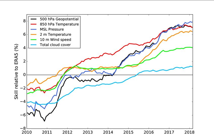
Anomaly correlation of 500 hPa geopotential reaching 80%

                                                                   2019?
                                                                    FV3

                                        Northern Extratropics

                                                October 29, 2014
T850 hPa ENS performance

                                              CRPSS=25%

                                              CRPSS=50%

                           October 29, 2014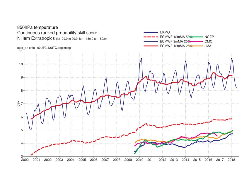
HRES skill relative to ERA5 – Nhem Extratropics
         Day 5                                          MSLP
                                                        T850
                                                        Z500
                                                        2 m temperature

                                                        10 m wind speed

                                                        Total cloud cover

                                           Score=SDEV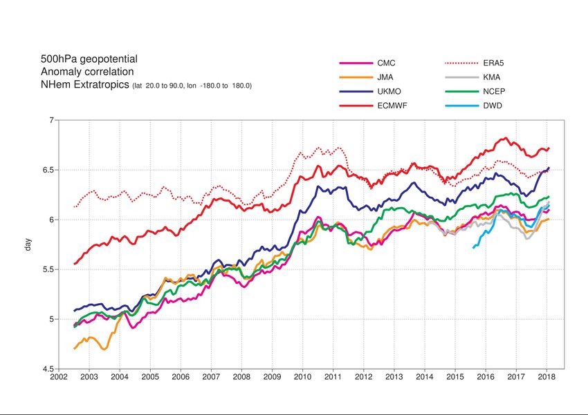
Recent Events - the last 12 months
  - Model      Upgrades:
    SEAS5 (Nov 2017)
    45r1 (June 2018)

     EUROPEAN CENTRE FOR MEDIUM-RANGE WEATHER FORECASTS   7
SEAS 5 Seasonal Forecast System Introduced

          JJA 2m temperature                               “Climate Change” in JJA 2m temperature in Israel
  May forecast verification comparison
 Red means SEAS5 better than System 4

                          EUROPEAN CENTRE FOR MEDIUM-RANGE WEATHER FORECASTS                             8
45r1: Improvements in precipitation along coast lines/lakes and over orography
from warm-rain microphysics numerics upgrade

          Example case study 14 May 2017 00Z 48hr forecast accumulated precipitation (mm)
                                   New warm-rain microphysics numerics
          E-suite (43r3)                         (45r1)                       UK radar (different colour scale!)

     4-8 mm                                                  20-24 mm                                     20-24 mm

         In warm-rain dominated situations the precipitation is no longer off the coast, but inland
               with maxima over orography, in much better agreement with the observations
New output parameter: Total lightning flash rate density

             Example of 15h ENS global forecasts (31 members) from 9 Aug 2015 at 00Z.

              ENS mean fT (over all members)                   Obs: ATDnet

               Prob (fT > 1 flash/100 km2/h)                   Obs: GLD360
Summary of some new developments in 45r1 Improved forecast aspects: • Precipitation at coastal interface • Short-wave radiation in the extratropics • Tropical circulation including tropical cyclones (HRES depths better – coupling) • Model error physical consistency & flow dependency • New model outputs for lightning and precipitation In general skill scores very slightly better.
Recent Events - the last 12 months
  - New    ECMWF Tools

     EUROPEAN CENTRE FOR MEDIUM-RANGE WEATHER FORECASTS   12
ecCharts
• New Profiles tool – positive feedback
• New Precipitation Type Meteograms – very positive feedback
• New Most Probable Precipitation type maps
• Some facilities not known about…!
Regional Boundaries
EUROPEAN CENTRE FOR MEDIUM-RANGE WEATHER FORECASTS 13Recent Events - the last 12 months
- Other
EUROPEAN CENTRE FOR MEDIUM-RANGE WEATHER FORECASTS 14eLearning @ECMWF- Please use!
https://www.ecmwf.int/en/learning/education-material/elearning-online-resources
Self-contained modules to be used either stand-
alone or as part of blended courses (eLearning Monthly
combined with face to face) forecast
Seasonal
Freely available Convection
forecasting
Learner-tailored approach to allow for different Ensemble
Parametrisation
forecasts
knowledge levels and learning styles
MARS ecCodes
Computing
ecFlow Metview
topics
Stochastic forecast Single column
Physics jumpiness model
EUROPEAN CENTRE FOR MEDIUM-RANGE WEATHER FORECASTS October 29, 2014 15WORKSHOPS in 2018 – please check out 2019 schedule and sign up!
• Workshop on shedding light on the greyzone
• Workshop on developing Python frameworks for earth system
sciences
• ECMWF/ESA workshop on using low frequency passive microwave
measurements in research and operational applications
• Workshop on observations and analysis of sea-surface temperature
and sea ice for NWP and climate applications
• Workshop: Hydrological services for business
• Workshop: Radiation in the next generation of weather forecast
models
• Workshop on Member and Co-operating State requirements for
ECMWF outputs in support of multi-hazard Early Warning
Systems
• Using ECMWF's forecasts (UEF2018)
• Hackathon: "Innovate with Open Climate Data"
• Workshop on physics-dynamics coupling 2018 (PDC18)
• Radio-Frequency Interference (RFI) workshop
• Annual Seminar: Earth system assimilation
• 18th Workshop on high performance computing in meteorology
• EGOWS – Operational Meteorological Workstations
EUROPEAN CENTRE FOR MEDIUM-RANGE WEATHER FORECASTS October 29, 2014 16Google:
“Forecast User Guide”
• A new a vastly updated web-based
version of this document was released
to MS/CS and other users in May
2018, in the forecast_user portal
• It provides helpful information, for
forecasters in particular, on these and
other topics:
– how the model formulations
work (in relatively simple terms)
– what ECMWF products are and
how to make best use of them
– where and when user
expectations, regarding
forecast accuracy, can be
elevated or lowered
Please Use! (try out search)
• This is a live document, undergoing
frequent updating, as and when
models and products change and our
understanding of them improves
EUROPEAN CENTRE FOR MEDIUM-RANGE WEATHER FORECASTS 17Upcoming Developments - the next 12 months
- Next Model Cycle:
46r1 – June 2019? – includes:
Continuous data assimilation
50 EDA members (instead of 25)
1h radiation time step in ENS
EUROPEAN CENTRE FOR MEDIUM-RANGE WEATHER FORECASTS 18Continuous data assimilation
OBS
cutoff
1 2 3 Current
cutoff
Effective cut-off time
1 2 3 Extra obs
is 30 minutes later
n-3 n-2 n-1 n Extra obs, start earlier
• Key point: Start running data assimilation before all of the observations have arrived
• Most of the assimilation is removed from the time critical path
• Configurations which were previously unaffordable can now be considered.
• Opens up the possibility of a fully continuous assimilation system.
EUROPEAN CENTRE FOR MEDIUM-RANGE WEATHER FORECASTS October 29, 2014 19Impact of 1 hourly radiation on ENS
Experiments: TCo639, 50 members, 91 levels, June-August, 44 inidates
z500 CRPS 2t CRPS
vs Analysis
vs Obs
• clear improvement in scores! 3% cost increase (~ 2 minutes runtime)
• additional benefit: consistency with HRES, good for future developmentUpcoming Developments - the next 12 months
- Other
EUROPEAN CENTRE FOR MEDIUM-RANGE WEATHER FORECASTS 22ecPoint products in ecCharts
• Point-wise rainfall predictions
• Account for sub-grid variability and gridscale bias (both vary with gridbox weather type)
• New collaborative project, MISTRAL, with Italian partners, just started:
– blending ecPoint output with post-processed LAM ENS output
Jerusalem Forecast for
06 to 18UTC
on Wed
EUROPEAN CENTRE FOR MEDIUM-RANGE WEATHER FORECASTS 23Long Term Verification: April 2016 – March 2017
Brier Score Reliability (smaller values correspond to better forecasts, perfect forecast = 0)
TP>0 mm/12h TP>10 mm/12h TP>50 mm/12h
Area under the ROC curve (bigger values correspond to better forecasts, perfect forecast = 1)
TP>0 mm/12h TP>10 mm/12h TP>50 mm/12h
Concept System VerificationecCharts – Improving the user experience
Actual status
• 95% of ecCharts layers are generated in less that 3s.
• Each new request is cached to optimise the response time
• New layers and products are requested by users and added
regularly
• But complaints about slow speed continue
Plan to improve
• Improve the user experience by using a ’google
tile' mechanism (zoom and pan will immediately be more fluid)
• Improve the cache-ability of the requests (the use of tiles will
help)
• Improve the 5% of slower requests.
• Improve the deployment procedure to take advantage of cloud
technology and new infrastructure.
25New Test Product Initiative – on Confluence Platform
• About to be Introduced
• Real Time
• User Feedback invited
• Products for:
– Weather Regimes, including Phase Space diagrams
– SSWs (because extended range may have more “skill” when SSW present at T0)
EUROPEAN CENTRE FOR MEDIUM-RANGE WEATHER FORECASTS 26Addressing Recent User Requests…
• More Turbine-related wind levels (renewables sector) ✔
• Indices for: drought, heat stress, icing (shipping) ?
• Smoother mean sea level pressure fields ?
• More convective indices
• Cross sections (3 types) ?
• Point rainfall ✔
• Revised CAPE computation ? ECMWF agrees to
do an internal review
landscape
• 6Z/18Z runs, hourly data ✔
is changing…
Prob (%)
>15mm
• Miscellaneous ecCharts-related ?
EUROPEAN CENTRE FOR MEDIUM-RANGE WEATHER FORECASTS 27Re-Analysis – ERA5 – 31km – Soon to Complete back to 1978
Ensemble spread included as a measure of uncertainty:
1971 CERA- 1971 ERA5: 1980 ERA5: 2018 ERA5:
20C: Upper-air data Early-satellite era Current observing
Surface pressure, systemLonger Term Developments at ECMWF:
Addressing model errors
EUROPEAN CENTRE FOR MEDIUM-RANGE WEATHER FORECASTS 292m temperature errors in the IFS
• Most LAMs are performing slightly better than HRES (smaller biases / RMS errors)
• HRES has slight cold bias (0.5-1C)
• HRES has a larger cold bias on hot days (~2C) ✪
• Finland is a performance ‘blackspot’ for HRES in winter ✪
✪: ECMWF task
team investigating
these issues
EUROPEAN CENTRE FOR MEDIUM-RANGE WEATHER FORECASTS 3010m Wind
• LAMs mostly better than HRES, though picture does vary
• HRES biases vary by country, but over-prediction of speeds seems common – e.g. by 1m/s, largest at night
• Conversely there remain strong signals of under-prediction over mountains (notably Iceland, Norway)
• ENS Spread-skill very poor over Scandinavia
RMSE
BIAS
2013 2017
T+48, HARMONIE-AROME vs HRES T+0 T+48
EUROPEAN CENTRE FOR MEDIUM-RANGE WEATHER FORECASTS 31Precipitation
• Summer convection in “arid climates” – degradation may have been introduced in 45r1, under investigation
• Unrealistic ‘precipitation bullseyes’, mainly in tropics – bug recently identified !
EUROPEAN CENTRE FOR MEDIUM-RANGE WEATHER FORECASTS 32Observed distributions
Using observations to constrain the of rain flux profiles
parametrization of evaporating rain
2 km
Example of rain rate retrievals from drizzling stratocumulus cloud at the ARM site, Graciosa, east N Atlantic, 18 months
1 km
Surface
IFS model Improved microphysics, 1-moment Improved microphysics, 2-moment
90%
80%
• no numerical thresholds
• 80% RH threshold dominates • removed numerical threshold
• realistic drop sizes and fallspeeds
• drizzle overestimated • more realistic fallspeeds
• predicted rain mass and number concentration
• drizzle flux drops too slow, then too fast
→ much closer to observed profilesConditional Verification – Linking Parameters
• Growth area for ECMWF, helps with physics understanding
• Example from Hungary, 2m temperatures stratified by (actual) cloud cover:
Mostly Clear days Mostly Cloudy days
RMSE HRES
RMSE
ALADIN
AROME
BIAS BIAS
• Follow up question – are the 2m temperature errors caused by cloud forecast errors ?
• Need “dual conditional verification”
EUROPEAN CENTRE FOR MEDIUM-RANGE WEATHER FORECASTS 34Other Miscellaneous Issues to Address….
• Wind Gusts: positive bias inland? Over-prediction bias increases with lead time? More results please!
• Lake Temperatures: Lakes Geneva and Constance poorly modelled
– Issue relates to deep water and initialisation using SST – can be improved.
• SST: interpolation issue near to coastlines – unrealistic discontinuous behaviour
– Known problem of MARS storage mechanism. Using nearest gridpoint interpolation can help.
• Near-coast Sea Ice: Issues reported in-year; 45r1 coupled HRES more resilient against OSTIA issues.
• Waves: French model performance impressive; ECMWF will incorporate related physics in cycle 46r1.
• Snow cover on ground:
– Spurious accumulation of snow when sleet falling. Bug-fix in-year helped, but more to do.
– Melting too slow. New snow scheme to come after 46r1.
EUROPEAN CENTRE FOR MEDIUM-RANGE WEATHER FORECASTS 35ECMWF 2019-2022
2019 – 2022

                                                                                                    Re-assessment of
                                                                                                    Bologna
                                                                                                     role of SV in the
     Decision office                                                                                    ensemble
     accommodation
                                                           Bologna
                Handover
                                                                        Copernicus
                of building
                                                                         renewal

                                HPC
                               delivery

         2019                             2020                           2021                   2022
          BREXIT
                                Strategy development
                                                              Council
                                     Member &
                       Staff
                                     Co-operating States
                                                                                                                          2030
                                                                                                                         Strategy

                                                                                       2025
                                                                                     Strategy

              EUROPEAN CENTRE FOR MEDIUM-RANGE WEATHER FORECASTS                                 October 29, 2014
Windstorm “Ana” Windstorm “Johanne”
• Limited potential to improve upon forecasts in situations like the “Ana” storm, without better observations
EUROPEAN CENTRE FOR MEDIUM-RANGE WEATHER FORECASTS 38You can also read