Recent developments in Portable Pilot Units and e-navigation Mariners' Workshop 2017, Vancouver
←
→
Page content transcription
If your browser does not render page correctly, please read the page content below
Recent developments in Portable
  Pilot Units and e-navigation
   Mariners’ Workshop 2017,
          Vancouver
Mariners’ Workshop 2017

  Regional presentations

  •PPU systems and e-nav tools used in
  Canada by pilots
  •Regional developments in PPUs;
      What is on the workbench
  •Challenges and wish lists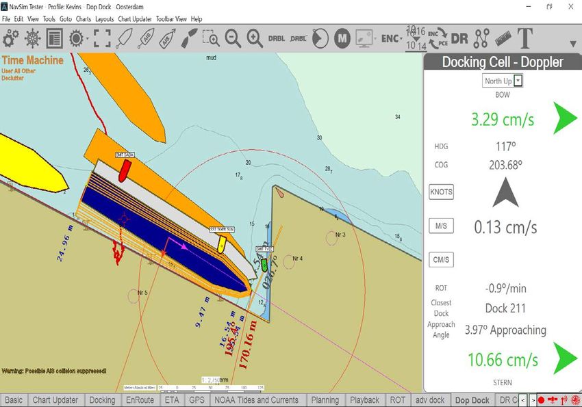
Great Lakes Pilots PPU
  Marimatec CAT1                                 Marimatec CAT ROT
  Independent positioning                        Auto-correct for wrong polarity
  GNSS receiver; GPS\Glonass\                    AIS Info and independent ROT
  WAAS enabled

                                  Wi-FI

                                                         Used as a router to connect
                                                         CAT1, CAT ROT, I PAd

                                                 Transas Pilot Pro App
                           Apple 12,9’’ Ipad Pro with SIM card
PPU New system features

  • Easy system setup – plug and play
  • Software easy to operate
  • Wi-fi network between CAT1/CAT ROT/ I Pad
    easy to configure and connect
  • Different « panels » available (settings,
    monitoring, planning tools, docking)
  • 12,9’’ Ipad Pro provides very good day and
    night picture
  • Routes and route monitoring
  • Possibility to record and playback tracks
  • Possibility to import and export routes, objects
    and tracks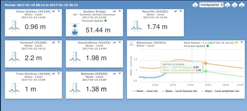
PPU system features - Cont
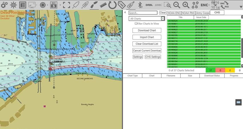
• Navigational charts:
- TX97Chart folio for Pilots produced from
the official S-57 data or paper charts with
monthly correction service
• Internet AIS service
• Navigational Alarms: colour indication and
sound signals.(XTE, low accuracy, etc)
• Docking and Mooring operation mode:
- Use of fore and aft motion vectors
- Use of predictors
- Use of fenderlines for limits and docklines
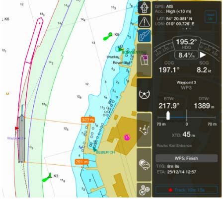
Transas Pilot Pro screenshots
Monitoring panel using predictors and docking
panel
Training and roll-out period

  • Training for GLPA pilots will start in
    March
  • 3 day course on pro pilot software, CAT
    1 and CAT ROT and I Pad fonctionalities
    along with electronic pilot forms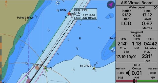
Wishlist 2017 – Great Lakes Pilots

  From last year’s list:
  •Obtain water levels info from chart
  datum instead of above sea level
  •Obtain more info via AIS such as buoys
  removal and deployment
  •Having a web portal similar to MARINFO
  on the Great Lakes; a web-based
  resource, combining information from
  USCG, CCG and Seaway Authority.
Atlantic Pilots PPU
  Marimatec CAT1                                 Marimatec CAT ROT
  Independent positioning                        Auto-correct for wrong polarity
  GNSS receiver; GPS\Glonass\                    AIS Info and independent ROT
  WAAS enabled

                                  Wi-FI

                                                         Used as a router to connect
                                                         CAT1, CAT ROT, I PAd

                                                 SEAiq Pilot software
                                                 Primar update Tracker for
                                                 chart corrections
                           Apple iPad Pro 12,9’’ Wi-Fi with SIM card
2016 • All Halifax Pilots and South East NFLD have received personal I Pad and training on SEA iq • 6 kits per district (CAT 1 + CAT ROT) shared by pilots on roster
2017 – Roll out schedule

  In 2017 the APA has placed an order for
  24 complete Marimatech units (Cat ROT &
  Cat 1)
  • This will complete the kitting out the SE
    Newfoundland and Halifax Pilots
  • Cape Breton Pilots will receive the
    SeaIQ training during Q2 and will be
    provided with their PPU's (Cat ROT &
    Cat 1 plus iPad) from the balance of the
    Marimatech order.
2018 – Roll-out schedule (Cont)
• In 2018, the APA will provide training
and I Pad with marimatecCAT1 and CAT
ROT for Saint John Pilots and West/East
Coast Newfoundland Pilots
• By the end of 2018, all APA employee
pilots will have a complete PPU
equipment.Wishlist 2017 – Atlantic pilots
• Secure funding, maintenance fees and
development of smartATLANTIC buoys
network – Chedabucto Bay in progress
• Development of a RTK GNSS package
for a pilot boat that can be used to
measure Wave and Tide heightsCorporation Pilotes du Bas St-Laurent PPU
Marimatec CAT1 Marimatec CAT ROT
Independent positioning Auto-correct for wrong polarity
GNSS receiver; GPS\Glonass\ AIS Info and independent ROT
WAAS enabled
Wi-FI
Used as a router to connect
CAT1, CAT ROT, I PAd
SEAiq Pilot software
Primar update Tracker for
chart corrections
Apple iPad Air 2 Wi-Fi with SIM cardLatest developments
• 1. Presets - allows for the quick and easy
display of preset locations
• 2. Own Ship Data Alarm - fires when data
source degrades from GPS external antenna to
ship’s AIS
• 3. Integration of SPINE to SEAiq in Traverse du
Nord area to obtain real-time water level at any
red buoysDevelopments - Cont
.Developments - Cont
Data uncertainty
Graphic display of data uncertainty valueDevelopments - Cont
CHS tide
Prediction and Recording of CHS tide
forecast data for forecasts aimed at tide
Smartphones case re-enactment in
improved UKC training.Corporation Pilotes St-Laurent Central PPU
BluetoothSystems under evaluation - CPSLC
Argus software SEAiq software
EOS Arrow 100 GNSS Geneq SX Blue II GPS
ROT Radian ROT ADQ2
Safe Pilot Marimatec software Qastor software
CAT ROT X Geneq SX Blue II
CAT ROT X ROT ADQ2
Whenever compatible, different tablets/computers/GPS and ROT will be tested on softwaresPPU Evaluation Score Sheet - CPSLC
New tools of the trade

 Connecting to OGSL via internet and creating a user profile allows to have real-time
 Water levels in desired pilotage area…
…and allows to obtain updated predictions
of any given tide station
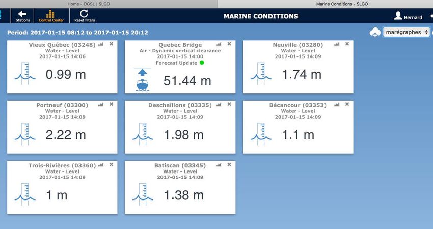
The « Smart » in Smartphones

 Tapping in OGSL website
 Using smartphone to obtain water levels (above)
 And water level predictions at tide stations.
 The format has been improved to become smartphone friendly
Wishlist 2017 – Laurentian Pilot groups

  • Apart from ongoing developments in
    both pilotage districts in e-nav, a
    general comment would be to ensure to
    maintain existing tools operational.
  • In Mid St.Lawrence district,
    considerations should be given to
    increase AIS info beyond VHF range.
BC Coast and Fraser River PPU
EOS Arrow 100 DGNSS
Sub meter accuracy ROTG5
Position Integrity monitoring (RAIM) Provides ROT and AIS info
1km bluetooth Increased Bluetooth range
Ready for new satellite constelations More accurate (providing
docking quality ROT)
integrity monitoring of the
heading
Lighter with increased battery
life
Panasonic FG-Z1 Mark 1 Tablet
Class 1 Bluetooth
Brilliant Sunlight viewing/ Good night
viewing
SD Card reader
4G / LTE modem
Battery life
Processing powerDevelopments 2016
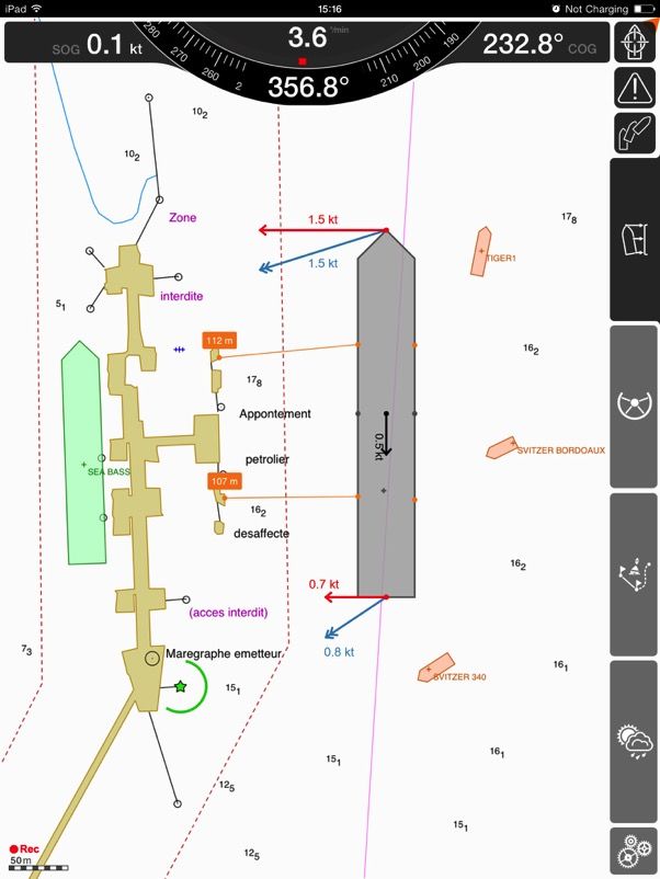
corridorsDocking Velocities
allow for Safer
berthing operations
Knowing the fender
ratings
COSCO
ROTTERDAM
280m x 39.5m
(90K disp)Harbour Berthin Scale g Scale 1:6000 1:1000
Wishlist 2017 – BCCP and Fraser River pilots

  • The following projects are currently
    either underway or being discussed
    – Berthing scale charts
    – Real time bridge height for 1st narrows
    – More access to Real Time met/hydro datas
    Ongoing – see Pacific e-nav report
    – Recommendations of Smart buoys at some
      pilot stations
Reminder of Mariners’ Workshop 2016
• AIS POSITION
- The quality of the AIS as a
position greatly varies from
one ship to the other.Reminder of Mariners’ Workshop 2016 - Cont
• The quality of the AIS position depends
– On the quality of GPS/DGPS feeding
the equipment
On the smoothing (“averaging”) of
the position
On the accuracy of the “AIS”
antenna position on the
vesselReminder of Mariners’ Workshop 2016 - Cont
• There must be a fix for this!!
Should it be legal to broadcast a false
position?
Shouldn’t the AIS position of a ship
(antenna position) be part of some
inspection?
Shouldn’t the AIS antenna position be
verified and displayed on the bridge?
“This is 2015”- Worse! 2016!This is 2017…
Mariners’ Workshop 2016

  Questions?
  Comments?

  Capt Bernard Boissonneault
  Chairman, CMPA Technical Committee
  vpl@apmc-cmpa.ca
  www.marinepilots.ca
Questions?
You can also read