Refining the priority river habitat map for England - Natural England Joint Publication JP012 - Natural ...
←
→
Page content transcription
If your browser does not render page correctly, please read the page content below
Natural England Joint Publication JP012

 Refining the priority river
 habitat map for England

First published 16 November 2015

www.gov.uk/natural-england
This report is published by Natural England under the Open Government Licence - OGLv3.0 for public sector
   information. You are encouraged to use, and reuse, information subject to certain conditions. For details of the
licence visit Copyright. Natural England photographs are only available for non commercial purposes. If any other
       information such as maps or data cannot be used commercially this will be made clear within the report.
                                              ISBN 978-1-78354-249-9
                                     © Natural England and other parties 2015
Refining the priority river habitat map for England

A report on initial revisions and proposals for on-going refinement

Chris Mainstone and Mark Rogers (Natural England), Ann Skinner and Steve Peters
(Environment Agency)

Executive summary

•   Initial refinements have been made to the priority river habitat map for England produced in
    2014, based on local quality assurance from EA and NE staff and limited contributions from
    other stakeholders.

•   Some rivers have been deleted from the map where the nationally available data used to
    construct the original version did not adequately reflect impacts.

•   Rivers and streams have been added to the map where local knowledge is sufficient, but there
    is a general lack of information on the headwater stream network to make such refinements.

•   The refined GIS layer is being made available for operational decision-making (Countryside
    Stewardship, land use planning, and Environment Agency permitting processes) and will be
    available to stakeholders shortly.

•   A strategic process is needed to make further incremental refinements to the map over a
    number of years, so that a comprehensive map can be generated including headwater
    streams.

•   Similar work is needed to refine the associated map of restoration priorities that was produced
    in the original 2014 mapping exercise.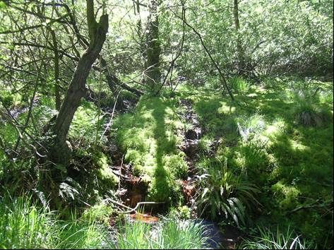
Contents

1. Introduction .................................................................................................................................................. 1

2. Description of the local refinement exercise ............................................................................................ 3

3. The refined map ........................................................................................................................................... 5

4. Making the refined layer available ........................................................................................................... 12

5. Proposals for on-going refinement of the priority habitat map ............................................................ 12

6. Other recommendations ........................................................................................................................... 13

6.1 Refining the restoration priorities map ................................................................................................. 13

6.2 Integrated development and interpretation of habitat and species mapping ................................... 13

6.3 Integration with Local Wildlife Site designations for rivers ................................................................ 13

References ..................................................................................................................................................... 14

Acknowledgements ....................................................................................................................................... 14

Annex 1 Priority river maps – frequently asked questions ....................................................................... 15

What is the priority river habitat map? ........................................................................................................ 15

What is the associated map of restoration priorities? .............................................................................. 15

Why are these maps needed? ...................................................................................................................... 15

How does this relate to the UK BAP definition of priority river habitat? ................................................. 15

How was the PHM developed? What is “naturalness”? ............................................................................ 15

What are the limitations of the maps? ......................................................................................................... 16

How will the maps be used? ......................................................................................................................... 16

Why are rivers on the priority habitat map worth conserving? ................................................................ 17

Why does the priority habitat map need refining? ..................................................................................... 17

Some of the rivers on the original priority habitat map are not very natural at all – how can that be? 17

Some rivers that I would expect to see on the original priority habitat map are not there – why? ...... 17

Does the local refinement process only consider whole WFD waterbodies?......................................... 17

What criteria have been used in the local refinement process to decide which rivers should be on the
map and which shouldn’t? ........................................................................................................................... 17

How does the identification of small rivers and streams dotted over the landscape promote
catchment-based management? .................................................................................................................. 17
None of the rivers in my area seem to be sufficiently natural to be included on the priority habitat
map – does that mean rivers aren’t a priority in my area? ........................................................................ 18

A river SSSI in my area isn’t on the priority habitat map – why? ............................................................. 18

Why are so many examples of river types that are included in the UK BAP priority river habitat
definition not included in the priority habitat map? .................................................................................. 18

How will priority habitat condition be assessed and reported? ............................................................... 18

What percentage of rivers are a priority? ................................................................................................... 18

Shouldn’t biodiversity hotspots be included on the priority habitat map? ............................................. 19

What is the relationship with other designations? .................................................................................... 19

What additional protection does the PHM afford a river? ......................................................................... 19
1. Introduction
A map of priority river habitat for England, based on the expanded UK definition of 2008, was
generated for the first time last year (Figure 1, Mainstone et al. 2014).This sought to capture the
most naturally functioning remaining examples of river habitat in England. A range of readily
available data sets were analysed within GIS to generate that version of the map.

The mapping exercise sought to identify watercourses that are sufficiently natural to be close to the
concept of high ecological status under the Water Framework Directive (WFD), considering the key
components of habitat integrity (physical, hydrological, chemical and biological). The selection
process adopted allowed one component to be slightly modified, but by no more than the concept
of good ecological status might allow. For smaller streams with no available data, naturalness of
land cover was used as a proxy to identify areas that are most likely to contain the most
natural/least modified watercourses.

A series of Frequently Asked Questions is provided at the end of the report to help people
understand the rationale used for mapping priority river habitat. Further information can be found in
the original mapping report (Mainstone et al. 2014) and in a broader narrative on freshwater habitat
conservation (Mainstone, et al. in draft).

Owing to the limitations of England-level data (in terms of spatial resolution, coverage of different
aspects of natural function, data patchiness etc.), the report on the original mapping exercise
highlighted the need for further consultation and refinement to capture local knowledge.

A refinement exercise has now been undertaken to remove the most significant anomalies from the
original map and add other suitable rivers and streams that were not originally included. This report
documents the work involved, and outlines a process by which the map can be progressively
refined over the longer term.

                                                                                                        1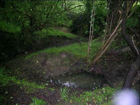
© Crown copyright. Natural England and CEH. 100022021. 2014

Figure 1. The original version of the priority river habitat map (from Mainstone et al. 2014)

The original mapping exercise also generated a map of restoration priorities (Figure 2). This was
an initial attempt to highlight rivers and streams that are not currently sufficiently natural to be
included on the priority habitat map, but which should be a priority for restoring natural habitat
function. No refinement work has been attempted on this map, but the proposals outlined at the
end of this report include suggestions for improving this map.

                                                                                                       2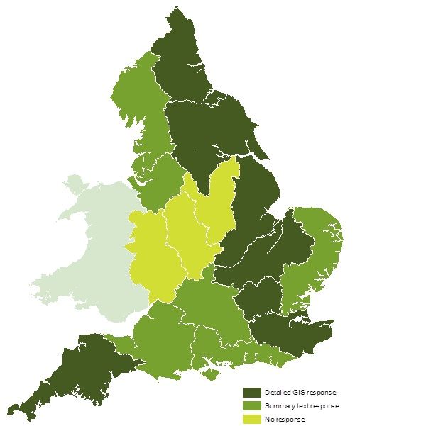
2. Description of the local refinement exercise
Refinements needed to be made relatively quickly so that a locally relevant map could be provided
for use in a number of operational activities, including the new Countryside Stewardship scheme,
land use planning and various permitting processes within the Environment Agency. Local
feedback on the map was primarily sought from local Environment Agency biodiversity leads,
working in collaboration with local Natural England and Wildlife Trust colleagues where possible.
There was insufficient time and resource for wider consultation during this initial exercise, but
proposals for further refinement at the end of this report are based on wider engagement with
stakeholders.

The starting point for the refinement exercise was the GIS version of the map that was created by
converting the original shapefile (generated by the Centre for Ecology and Hydrology) into a layer
based on the Detailed River Network (http://data.gov.uk/dataset/detailed-river-network2).

                       © Crown copyright. Natural England and CEH. 100022021. 2014

Figure 2. Priorities for restoration generated by the original mapping exercise (Mainstone et
al. 2014)

                                                                                                     3
The most important task was to remove from the map watercourses known to be significantly
modified. These may have appeared on the map because of inadequate information on a specific
aspect of natural habitat function, or because of spatial variations in the level of modification within
a WFD water body (the spatial unit used for the original GIS analysis).
The second task was to identify watercourses not on the original map but which should be added,
because they are known to be highly natural. Such watercourses are most likely to be absent from
the original map because they are too small to be highlighted by available England-level data sets,
particularly WFD data. Whilst the original map highlighted headwater areas where highly natural
streams are more likely to be found, the streams themselves were not generally selected because
of lack of data.
This secondary task was by far the most challenging. Environment Agency information on the river
network is largely restricted to sizeable watercourses where monitoring and permitting processes
are focused. Natural England staff may have knowledge of the naturalness of smaller streams, but
mainly within the protected site network where casework is focused. Wildlife Trusts may equally
have some knowledge of smaller streams, but this is most likely to be patchy.
Local Environment Agency biodiversity leads were asked to make returns either directly within the
original GIS layer, by annotating high resolution local print-outs of the GIS layer, or by spreadsheet
with precise National Grid References of the start and end points of watercourses to be excluded
or included. The exercise was deliberately based on subjective judgement, but using the same
naturalness principles outlined in the original GIS analysis (see Section 1). This approach was
adopted because available local knowledge is not available in the form of quantitative datasets, or
at least not in data that are easily comparable across sites in a quantitative way.
The consultation process was made more protracted by the considerable operational pressures on
local staff, which placed limitations on pro-active engagement. We are grateful to all those who
managed to find the time to respond (see the Acknowledgements at the end of the report). In all,
13 out of 16 areas provided a response of some description (see Figure 3). National specialists
also provided some input to the refinement process, particularly on the location of highly natural
streams. Valuable input was also made by external stakeholders in some areas where knowledge
was particularly lacking and opportunities for engagement arose.
4© Crown copyright. All rights reserved Environment Agency. 100026380. 2015.
Figure 3. Responses from Environment Agency lead contacts
3. The refined map
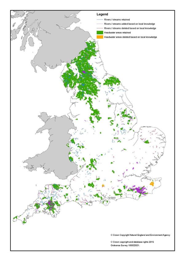
Deletions and additions to the original map are shown in Figure 4 – a separate high resolution
version of this is provided with this report. In some areas, there have been a considerable number
of deletions, where the England-level data and associated analysis did not reflect the levels of
modification observed on the ground. This includes both watercourses and headwater areas, the
latter where local staff felt they could confidently say no natural streams occur (for instance, where
built development or the permeability of the soils and underlying geology mean that no natural
streams exist).Deletions are most evident in East Anglia, where artificial modifications are
ubiquitous in rivers of any size. The numbers of additions vary widely between areas, depending
on how much time local contacts could devote to the task and the existing level of knowledge of
the headwater stream network where most additions are located.
5Figure 4. Refinements made to the priority habitat map
6Where specific small streams have been highlighted by responses, these have been added as
lines to the priority habitat map. Where these occur within the headwater areas most likely to
contain highly natural streams, this does not necessarily mean that other streams in those areas
are not suitable for inclusion. They may be, but there is currently no local knowledge of their
naturalness.
The greatest numbers of additions of headwater streams are in lowland areas, where there is
reasonable local knowledge of at least some of the stream network and it is known that some
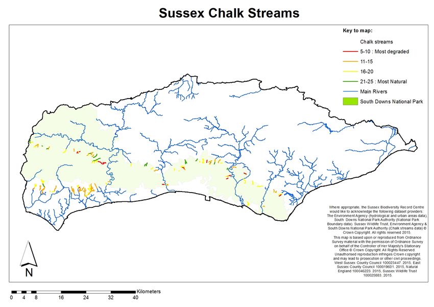
streams have escaped widespread impacts on the headwater network. Key areas are the South
Downs, the High Weald, and the South Cotswolds in Gloucestershire. For the South Downs, the
Sussex Wildlife Trust (SWT) has undertaken ground-breaking work to identify natural and impacted
streams, and was able to provide a GIS layer indicating the naturalness of all the streams running
off the Downs based on bespoke survey work (Figure 5). For the High Weald, bespoke information
was not available but streams were added based on their presence within certain SSSIs or ancient
woodland. For the South Cotswolds, specific streams were identified by Stroud District Council
from site inspections resulting from the need to deliver more sustainable flood management -
stream restoration is seen as an important flood control measure in their catchments.
7Figure 5. Survey-based assessment of streams running off the South Downs (copyright Sussex Wildlife Trust) (High scores indicate high
naturalness)
8This exercise has highlighted highly natural headwater streams connected to intact valley head
mires, springs and flushes in parts of lowland England that are not generally known for such
natural headwater habitat. Some of these streams are located in SSSIs notified for terrestrial
habitat, mainly ancient woodland (particularly the High Weald), but a good deal have no protection
(particularly those running off the South Cotswolds and South Downs). Examples of the streams
added to the map from these areas are shown in Figures 6 to 10.
Figure 6. The Shard stream near Minchinhampton, Gloucestershire
One of many natural tufa-forming streams running off the South Cotswolds limestone plateau
through incised wooded valleys. Large woody debris is a major feature, creating scour pools,
riffles and lateral channel movement to form a complex habitat mosaic for characteristic species
assemblages. Like many of these streams it has had no protection status, but is now on the priority
river habitat map.
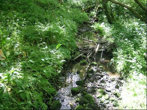
9Figure 7. The Harting Stream near East Harting, West Sussex
A highly energetic winterbourne running off the South Downs over greensand., with extreme
sinuosity and abundant riparian trees and woody material. One of a number of similar streams
which have had no protection status but are now on the priority river habitat map.
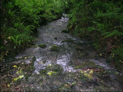
Figure 8. Botany Bay stream near Duncton, West Sussex
A highly energetic perennial chalk stream running off the South Downs through an incised valley.
The strong flows and steep channel gradient create a habitat that is very different from classic
chalkstreams. Rare mosses grow on exposed boulders and the coarse substrates host a diverse
invertebrate assemblage. It has had no protection status but is now on the priority river habitat
map.
10Figure 9. Intact mire-stream transition in Ashdown Forest, High Weald, Kent
The mire-stream systems of the forest are highly natural, generating a diverse habitat mosaic for
characteristic assemblages which include rare mosses and a range of stonefly species. The
streams fall within Ashdown Forest SSSI but will receive greater recognition by their inclusion on
the priority river habitat map.
Figure 10. A headwater of the Bartley Mill stream, running off the High Weald near Frant,
East Sussex
One of many ghyll streams running through the abundant ancient woodland of the High Weald.
Fallen trees, debris dams and leaf litter are major features of these streams, forming a complex
habitat mosaic that is strongly connected to intact Sphagnum-rich flushes. This stream has had no
11protection status but like all such streams in the High Weald it is now on the priority river habitat
map.
We are confident this consultation exercise has identified most of the deletions that needed to be
made. However, the exercise has only scratched the surface of the additions that are required
within the headwater stream network. Our knowledge of the headwater stream resource is
extremely patchy, and even this existing knowledge is not easy to assemble into an England-level
map. Most local refinements so far have been focused on identifying the relatively few natural
headwater streams in lowland areas, where much of the stream resource has been heavily
degraded by intensive agriculture. In upland areas, whilst some pressures can be intense (such as
moorland gripping and atmospheric pollution), the headwater stream resource is generally much
more natural considering all key components of habitat integrity, so identifying all suitable
watercourses for the priority habitat map will be a much larger undertaking.
4. Making the refined layer available
The refined GIS layer will be incorporated into the Countryside Stewardship targeting engine and
the Environment Agency’s Easimap system for informing permitting decisions. It will also be made
available as part of Natural England’s Single Habitat Layer. Further options for easy stakeholder
access to the GIS layer are being considered.
5. Proposals for on-going refinement of the priority habitat map
The map is, as with all habitat inventories, still very much a work-in-progress. Establishing and
maintaining a robust map requires much better understanding of the headwater stream resource in
particular. This is a long-term undertaking that is discussed in the next section.
Further refinements to the priority river habitat map need to be planned in the style of a typical
habitat inventory project, focused on the headwater stream resource but also capable of better
reflecting our local understanding of the naturalness of larger watercourses. This process needs to
be open and inclusive, allowing all partners (Wildlife Trusts, Rivers Trusts, national NGOs,
academics etc.) to contribute to the improved knowledge base and share in its benefits.
It is proposed that a national project be established to:
1. co-ordinate strategic screening/survey of headwater areas so that further highly natural
streams can be identified and added to the priority habitat map;
2. develop a meta-database of information on the headwater stream resource;
3. collate accessible and emerging information on highly natural headwater streams, including
site surveys and a photographic library;
4. make on-going refinements to the priority habitat map and provide regular GIS updates for
inclusion in key operational decision-making frameworks and circulation to stakeholders;
5. provide a focal point for the conservation of headwater streams and their associated mires,
flushes and springs, promoting better understanding of the importance of the headwater stream
resource for wildlife and vital ecosystem services;
6. foster local stakeholder stewardship of headwater streams, promoting coordinated and
concerted action on local stream networks (e.g. the High Weald stream network); and
127. provide a vehicle for disseminating key messages about the management of different types of
headwater stream.
Given their broad remit for advancing understanding of freshwater and sustainable management of
fresh waters, and their track record in managing information in the public interest, it is proposed
that the Freshwater Biological Association would be an appropriate focal point for this activity.
The work of the Sussex Wildlife Trust on South Downs headwater streams is an example of best
practice in undertaking local screening and survey work, which should be used as a model within a
national co-ordinating project.
6. Other recommendations
6.1 Refining the restoration priorities map
This map currently depicts all rivers classed as chalk river (from the original UK BAP chalk river
habitat map) or active shingle river (using information on relevant habitat features from River
Habitat Survey) that are not included on the priority river habitat map. Over time this should be
refined to reflect agreed local priorities for restoring natural habitat function to rivers, based on
what is achievable where. This is likely to require a different refinement process to the one outlined
above for the priority habitat map.
6.2 Integrated development and interpretation of habitat and species mapping
Mapping work on priority river habitat should be developed in tandem with any work to map
biodiversity hotspots associated with river and other freshwater habitats. Our ambition should be to
conserve species in naturally functioning habitats wherever possible (Mainstone et al. In draft). The
overlaying of the mapped habitat and species outputs is important, so that we can understand
where biodiversity hotspots are generated by natural habitat function and where they are
dependent on artificial modification of freshwater habitats. Biodiversity hotspots supported by
natural habitat function should be our highest priority for protection and extension. Hotspots that
are generated by artificial habitat modification need careful consideration in relation to the
restoration of natural habitat function, based on a clear vision for how priority species are
conserved within a more naturally functioning ecosystem.
The priority habitat map can be used, as it develops, to encourage species recording effort to be
focused on remaining naturally functioning habitat, to help address mis-matches in data that are
solely due to patchy species records.
6.3 Integration with Local Wildlife Site designations for rivers
Some local areas are actively seeking to notify rivers as Local Wildlife Sites, and other areas are
likely to undertake similar work in the future. It would be useful to harmonise the approach to
selecting riverine LWS with priority river habitat mapping work.
13References
MAINSTONE, C.P., HALL, R., AND DIACK, I. (In draft) A narrative for conserving freshwater and
wetland ecosystems in England. To be published as a Natural England report.
MAINSTONE, C.P., LAIZE, C., WEBB, G. AND SKINNER, A. (2014) Priority river habitat in
England – mapping and targeting measures
Acknowledgements
We are indebted to the following local Environment Agency staff for the responses that made these
refinements possible:
Erica Adamson Peter Mischenko
Amanda Best Matthew Parr
Gail Butterill Tom Reid
Adam Cave Duncan Revell
Tom Cook Lesley Saint
Rob Dryden Graham Scholey
Jo Heisse Sarah Jane Scott
Richard Knott Fiona Steele
Ian Marshall Pete Turner
Rachael McFarlane Amy Wilson
Also to Fran Southgate (Sussex Wildlife Trust) for use of the comprehensive data collected on the
headwater streams of the South Downs, and Chris Uttley of Stroud District Council for imparting
his knowledge of south Cotswolds headwater streams. Finally to local Natural England staff who
managed to engage with local Environment Agency contacts over their returns.
14Annex 1 Priority river maps – frequently asked questions
What is the priority river habitat map?
In England, rivers with high levels of naturalness that support characteristic species assemblages
are now rare because so many have been modified or subjected to physical, hydrological, water
quality or biological (e.g. non-native species) pressures. The priority river habitat map (PHM) is
intended to capture those watercourses judged to remain in a highly natural condition, based on
the hydrological regime, water quality, physical morphology and biology stressors (particularly non-
native species and fisheries management).
What is the associated map of restoration priorities?
This map shows rivers that are not sufficiently natural to include on the PHM, but are of particular
priority for restoration because they are examples of certain river types (chalk rivers and active
shingle rivers) that are of particular conservation interest and limited spatial extent.
Why are these maps needed?
Government recognises ‘habitats and species of principal importance’ for the conservation of
biological diversity under Section 41 of the Natural Environment and Rural Communities Act 2006.
Section 40 states that "Every public authority must, in exercising its functions, have regard, so far
as is consistent with the proper exercise of those functions, to the purpose of conserving
biodiversity". Section 3 places a duty on the Secretary of State to “take such steps as appear to …
be reasonably practicable to further the conservation of the ….types of habitat included in any list
published under this section, or promote the taking by others of such steps”.
Efforts have been made to identify and map “priority habitats and species” in England, but this
exercise was never completed for rivers, until now. The original mapping exercise was undertaken
in 2014 by the Centre for Hydrology and Ecology (CEH), Natural England (NE) and the
Environment Agency (EA) on behalf of Defra and the Terrestrial Biodiversity Group which oversees
the implementation of England’s Biodiversity Strategy, currently named Biodiversity 2020. The
maps will be used to prevent the deterioration of our most natural remaining rivers, and to focus
work to restore natural processes where possible.
How does this relate to the UK BAP definition of priority river habitat?
The formal UK BAP definition encompasses headwater streams, chalk and active shingle rivers,
and rivers with Ranunculion/Batrachion vegetation (EU Habitats Directive Annex I river habitat
type), as well as rivers with certain priority species. In England, a new analysis has been
undertaken, focussing on naturalness in recognition of the importance of natural processes in
delivering sustainable river habitats that support characteristic assemblages of species. This is
intended to provide much better alignment with the principles of the Water Framework Directive
and the SSSI notification process, both of which are based on protecting natural river habitat
function as far as possible. This new approach was agreed by the Rivers Biodiversity Integration
Group and endorsed by the Terrestrial Biodiversity Group as part of Biodiversity 2020 delivery.
How was the PHM developed? What is “naturalness”?
Highly natural rivers have natural flow, nutrient and sediment delivery regimes; minimal physical
modifications to the channel, banks and riparian zone; longitudinal and lateral hydrological and
biological connectivity; an absence of non-native species and low intensity fishery activities. Such
rivers are now rare in the UK, with lowland rivers subject to a far greater range of pressures than
those in the uplands.
15The maps were developed through a national GIS analysis undertaken by CEH using data from NE
and EA on the main components of habitat integrity:
• hydrology (deviations from “natural” flow regime);
• physical modifications (using the Habitat Modification Score from RHS, the number of in-
channel structures and Flood Defence Assets);
• chemistry (DO, ammonia, phosphate levels and pH); and
• and biology (absence of non-native species).
WFD waterbody status assessment was also considered. The 3 high ecological status and 11 high
morphological status waterbodies in England were included, whilst artificial or heavily modified
waterbodies were excluded from the maps.
The PHM also includes those headwater areas with the highest proportion of semi-natural land
cover, as a proxy measure for naturalness because we lack direct data on such streams. As semi-
natural land use is much more prevalent in the uplands, this has given a geographical bias in the
results. This bias is somewhat misleading, as many upland streams have been degraded by
moorland gripping and burning which generates heavy loads of organic particulates, whilst some
upland areas suffer from a legacy of acid pollution and metal ore mining. Evaluation of the
naturalness of headwater streams needs much more work, covering all types including rarities
such as streams fed by tufa-forming springs.
What are the limitations of the maps?
The original maps are necessarily relatively crude as they were developed using nationally
available England-level datasets. Whilst the GIS layer of the priority habitat map is of high spatial
resolution to match the Environment Agency’s Easimap system and Natural England’s Single
Habitat Layer, the national analysis on which the PHM is based cannot discriminate differences in
naturalness within a WFD waterbody. Even at waterbody-scale, data are patchy so there is
considerable risk of anomalous judgements in the original PHM. A process of refinement using
expert judgement has been undertaken, and the maps will be periodically reviewed and revised to
take account of new information.
How will the maps be used?
The new priority river habitat map will help us to protect and enhance the most natural examples of
England’s rivers and streams from further impacts on natural habitat function, and will provide
impetus to tackle whatever impacts on natural function these watercourses might suffer from. Use
of this map relates to achieving Outcome 1A of England’s Biodiversity 2020 strategy. The
restoration priorities map will help us focus efforts to restore natural river habitat function in the
wider river network, to help meet Outcome 1B of Biodiversity 2020.
The maps will be used to help target agri-environment funding through the new Countryside
Stewardship Scheme. The Environment Agency will use the maps in River Basin and Catchment
Flood Risk management plans and strategies, when planning capital schemes and maintenance
programmes, and when determining applications for environmental permits. The maps will be vital
for screening environmental permit applications to ensure the best rivers are protected from
damaging activities, and when determining priorities for restoration action to meet WFD objectives.
Other Biodiversity partners are encouraged to use the maps to highlight where special attention
should be focused to protect or restore natural river habitat function.
16Why are rivers on the priority habitat map worth conserving?
Natural river habitat function provides the best and most sustainable expression of characteristic
biological communities associated with rivers, and generates conditions that provide greatest
resilience to climate change. There are very few remaining near-natural rivers and streams in
England; the majority are within the headwater stream resource which is not well-protected by
either the Water Framework Directive or the designated site network. The PHM will help us to
protect and enhance these watercourses beyond what could be achieved through measures to
achieve ecological status objectives under the WFD.
Why does the priority habitat map need refining?
If the map is to be effective in influencing decision-making over new developments and restoration
activities, it must reflect local knowledge of where our most natural remaining watercourses are.
We know inadequate data led to considerable limitations in the original version of the map; if left
unrefined it would not be sophisticated enough to inform local operational decision-making.
Some of the rivers on the original priority habitat map are not very natural at all – how can
that be?
The national analysis used a structured approach to the available data and tried to select WFD
waterbodies that were close to what might be considered high ecological status, but falling short on
one component of habitat integrity (e.g. physical habitat, hydrology, water quality) by no more than
what might be considered good ecological status. If a poor quality waterbody is currently on the
PHM it is either an artefact of the nationally available data or the way in which the data have been
aggregated. Data for an attribute that would otherwise downgrade the waterbody may have been
missing. Alternatively, a degraded river may be part of a waterbody that is otherwise quite natural,
in which case it would be allocated the naturalness of the wider waterbody.
Some rivers that I would expect to see on the original priority habitat map are not there –
why?
This is probably because of missing data – if there were no data to score a key component of
naturalness, the waterbody wouldn’t have received an overall naturalness score and therefore
could not go on the map. It may also be because a quite natural tributary is a part of a wider
waterbody that is otherwise not sufficiently natural to be included on the map.
Does the local refinement process only consider whole WFD waterbodies?
No. There may be very natural tributaries within a waterbody that is otherwise not sufficiently
natural to be included on the priority habitat map – these should be identified and included
wherever possible. We recognise that there are serious limitations around what we know of smaller
rivers and streams that are not subject to WFD monitoring.
What criteria have been used in the local refinement process to decide which rivers should
be on the map and which shouldn’t?
There has been no rigorous numerical analysis because the data are not available. Best
professional judgement has been used, based on local knowledge and the principles used in the
national mapping exercise. A general absence of pressures is sufficient to justify the inclusion of a
watercourse at the local level.
How does the identification of small rivers and streams dotted over the landscape promote
catchment-based management?
Catchment management has to be built up from an understanding of the detailed needs of
watercourses within a catchment. Developing a priority river habitat map in this way is no different
17to understanding the ecological status of different WFD waterbodies or of different protected sites
in a catchment. Catchment management planning is about integrating such information and
building the best management framework possible for protecting remaining interests and restoring
biological diversity where possible.
None of the rivers in my area seem to be sufficiently natural to be included on the priority
habitat map – does that mean rivers aren’t a priority in my area?
Some areas of England have very little in the way of natural rivers and streams left, and that’s just
a fact of life. However, there may be headwater streams tucked away that have escaped notice,
particularly those within terrestrial SSSIs or other semi-natural habitat (particularly ancient
woodland). If the larger rivers of your area are not sufficiently natural, there may well be hidden
gems in the stream network. In areas where they have been looked for, they have generally been
found – even in unlikely parts of lowland England.
A river SSSI in my area isn’t on the priority habitat map – why?
River SSSIs would only be suitable for inclusion if they meet the level of naturalness that we would
expect from any other river or stream. River SSSIs are dealt with through a separate Biodiversity
2020 target within Outcome 1A so there is no need to worry about their priority level – they are
already a priority for protection and restoration where necessary. The focus of the priority river
habitat work is on non-SSSI river habitat.
Why are so many examples of river types that are included in the UK BAP priority river
habitat definition not included in the priority habitat map?
If all the examples of all river types included in the UK BAP priority habitat definition were shown
on the priority habitat map, nearly all rivers and streams in England would be on the map. We
needed a way of working with the UK BAP definition and coming up with a subset of the river and
stream resource that comprised our most ecologically important sites. The only rational basis for
doing this was to use naturalness and natural habitat function. This approach has generated a
common language between the main drivers for river habitat conservation – the Water Framework
Directive, SAC/SSSI notification, and priority habitat (see Mainstone and Hall, in draft). Rivers and
streams not included on the priority habitat map are not forgotten - many are on the associated
restoration priorities map. Restoration of natural habitat function on any river and stream is
considered to count towards priority river habitat objectives through the different outcomes under
Biodiversity 2020 (1A, 1B and 1D).
How will priority habitat condition be assessed and reported?
CEH, NE and the EA are currently engaged in a collaborative project to develop proposals for a
monitoring and assessment regime for priority river habitat objectives (as well as priority lake and
pond habitat objectives). This will build on the foundation of WFD and protected site monitoring
and add in other monitoring programmes (such as Countryside Survey) to build a representative
picture of natural river habitat function across the river network, Habitat function attributes (such
as lateral and longitudinal connectivity) and assessment of neglected habitats (such as the riparian
zone) will be included to provide a more holistic picture of habitat condition than is possible through
WFD assessment, extended into the headwater stream resource where information is so lacking.
What percentage of rivers are a priority?
This is not an easy question to answer, not least because it depends on the spatial resolution of
observation (i.e. which map scale is being considered). The PHM contains relatively few rivers and
streams, comprising a low percentage of the river habitat resource –this is appropriate for the high
level of priority given to the map. However, the PHM also includes a larger number of headwater
18areas, and the specific watercourses that are worthy of being on the PHM within these areas is
often unknown. There is a considerably greater proportion of the river network on the restoration
priorities map, reflecting the degree of modification to which England’s rivers have been subjected.
We will work on refining this map so that it better reflects local priorities for restoration based on
what is feasible.
Shouldn’t biodiversity hotspots be included on the priority habitat map?
We want to conserve all native riverine species (including priority species) within naturally
functioning river ecosystems wherever possible. Natural river habitat function provides suitable
conditions for supporting all of our native riverine flora and fauna within a dynamic and complex
habitat mosaic. Individual species may be present at a location, or found in abnormally high
abundance, because of artificial modifications to river habitat (e.g. impoundment, eutrophication,
flow modification). We need to ensure that we do not create conflicts between conserving species
where they are currently located and conserving natural ecosystem function. The PHM and
biodiversity hotspots are therefore different but linked perspectives on river conservation. Where
they coincide the two are compatible and we can protect and restore natural ecosystem function
with confidence – where they do not coincide careful planning is needed for any measures to
restore natural ecosystem function, to ensure that we have a strategy for accommodating existing
species.
What is the relationship with other designations?
The 2014 report provides maps showing the spatial relationship of priority rivers with existing river
SSSIs, chalk rivers, active shingle rivers and headwaters. These can be summarised as follows:
• There is a reasonable association with river SSSIs, although the PHM is generally skewed
towards smaller rivers and streams and the river SSSI series is skewed towards main stem
rivers (the PHM often includes non-SSSI tributaries of main rivers that are SSSI).
• There is relatively little association with chalk rivers, mainly because chalk rivers have been
extensively modified.
• The level of association with active shingle rivers is highly variable, with the best
associations in upland areas.
• The headwater stream resource is huge, comprising around 50% of total river length at
1:50,000 map scale – the PHM selects the most natural parts of this resource.
There are also local initiatives to establish Local Wildlife Sites for rivers. There is no national
picture of how far this work has progressed, so it is not possible to characterise the relationship
with the PHM. However, it is hoped that a common rationale can be agreed that will ensure the
work can work in harmony with priority river habitat mapping.
What additional protection does the PHM afford a river?
The priority river map adds value to the WFD and the designated site series by providing additional
recognition for our most natural rivers. For planning, consenting and permitting purposes,
preventative measures will be needed to help protect priority rivers from further losses of
naturalness and cumulative pressures.
19You can also read