REMOTE SENSING IN SUPPORT OF PUBLIC SERVICE OF WALLONIA ACTIVITIES
←
→
Page content transcription
If your browser does not render page correctly, please read the page content below
Belgian Earth Observation Day 2014
                              Thursday 20 November

          REMOTE SENSING IN SUPPORT OF

PUBLIC SERVICE OF WALLONIA ACTIVITIES

                               Service public de Wallonie
                                  Secrétariat général
                             Département de la Géomatique
SECRÉTARIAT GÉNÉRAL
Département de la Géomatique
                     Dominique
Direction de l’Intégration         Buffet – Christophe Schenke – Catherine Meunier
                           des géodonnées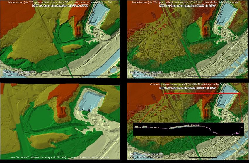
Context of public sector
• The use of geographical information is growing continuouslys:
   – Considering the evolution of regional, national and EU policies
   – Responsibility for making a broad range of management decisions daily
   – To achieve our missions of public services

• In order to satisfy this demand, geo-databases must be:
   – Exhaustive for mapping and analysis of all the territory
   – Frequently updated with the highest possible metric and thematic
      accuracy

• Sources of updates:
   – Must be operational, reliable, highly recurrent and mutualisable to
     remain cost effective
   – Must provide accurate, affordable and accessible geospatial
     information that can be used alone or in combination with other type
     of data and information (i.e: from statistical and administrative data)
       SECRÉTARIAT GÉNÉRAL
       Département de la Géomatique
       Direction de l’Intégration des géodonnées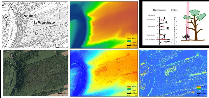
Aerial images
• Context:
   – The mainstay of remote sensing application => orthoimages
   – VHR images georeferenced and orthorectified (50cm - 25 cm)
   – 3-4 spectral bands (VIS+NIR)
   – Time-series : 1994-2000; 2006-2007; 2009-2010; 2012-2013; 2014; 2015
     ...

  1994-2000                             2006-2007   2009-2010         2012-2013

                                                                NIR           NIR

       SECRÉTARIAT GÉNÉRAL
       Département de la Géomatique
       Direction de l’Intégration des géodonnées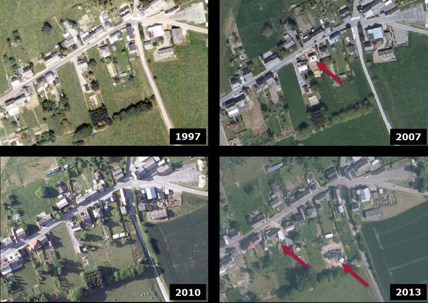
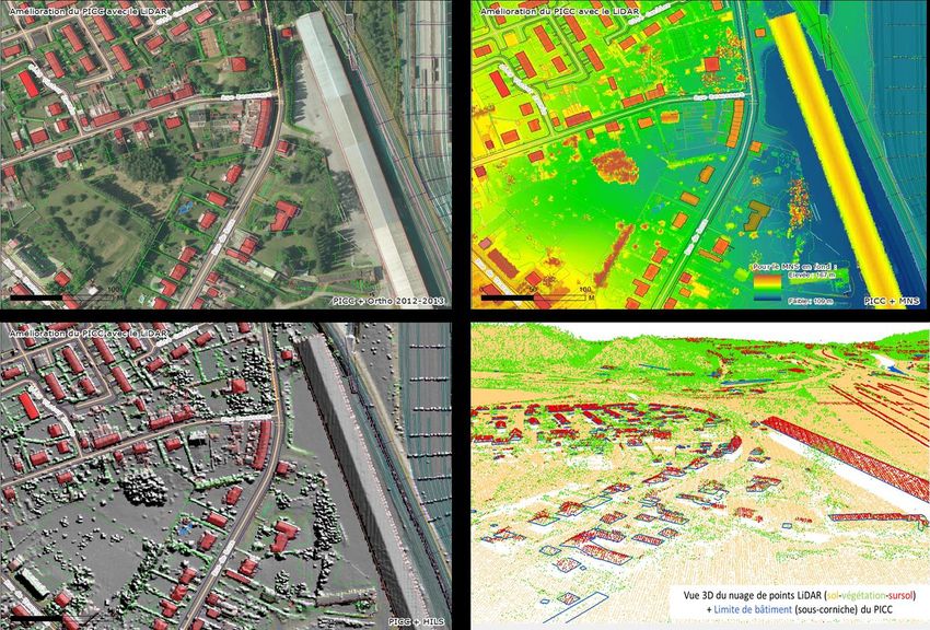
Aerial images
• Feature identification & extraction (PICC)

       SECRÉTARIAT GÉNÉRAL
       Département de la Géomatique
       Direction de l’Intégration des géodonnées
Aerial images
   • Common Agricultural Policy (CAP) :                           Area declaration and aid application
                                                                  Land Parcel Identification System
                                                                  Control of direct payments

                                                          Declaration:                  Control:
                                                          Location in aid application   Boundary stored in GIS
                                                          Area claimed by farmer        Prevents double declaration
                                                          Use declared by farmer        Official area
Source: http://agriculture.wallonie.be/ds/

              SECRÉTARIAT GÉNÉRAL
              Département de la Géomatique
              Direction de l’Intégration des géodonnées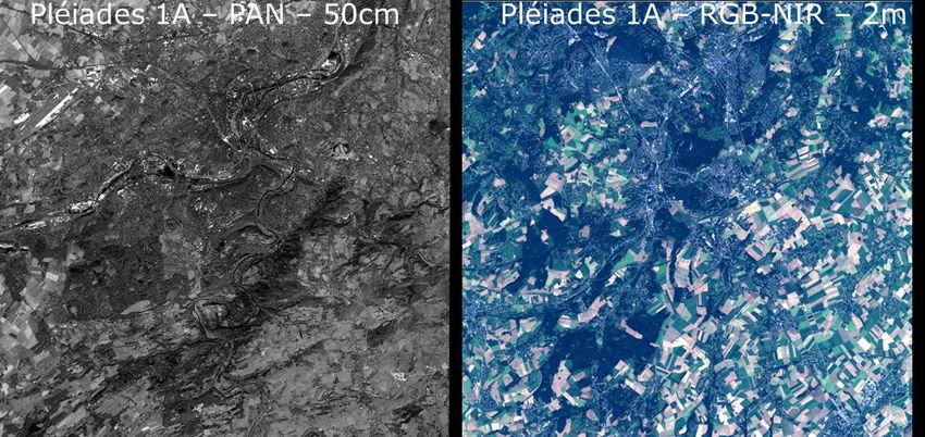
Aerial images
• Change detection:

      SECRÉTARIAT GÉNÉRAL
      Département de la Géomatique
      Direction de l’Intégration des géodonnées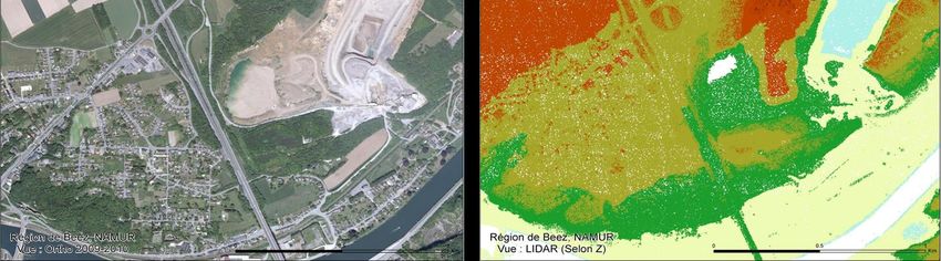
Airborne LiDAR
• Context:
   LiDAR products provide representations of the 3-dimensional landscape in
   several common GIS data structures: raster, point, and TIN surface.
    – Derivate product as digital elevation models (DEM's), digital terrain
      models (DTM's), digital surface models (DSM's), and triangulated
      irregular networks (TIN's).
    – Provide intensity information => feature extraction and object-based
      classification using descriptive features relatives to the object (spectral,
      texture, shape, height…)

       SECRÉTARIAT GÉNÉRAL
       Département de la Géomatique
       Direction de l’Intégration des géodonnées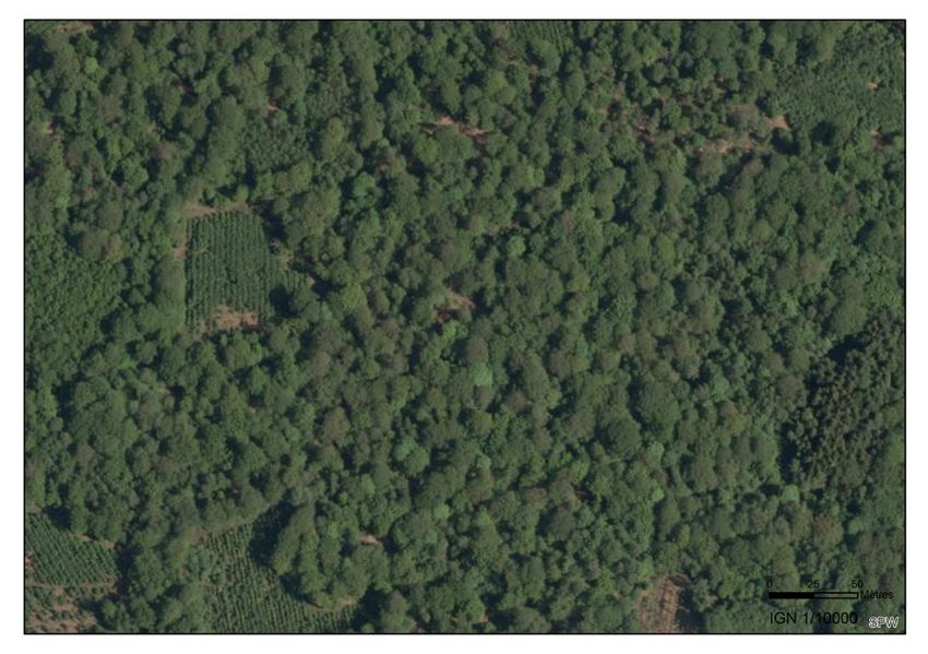
Airborne LiDAR
• Applications: Altimetry 0.4cm - Planimetry 1m - Density : 0.8 pt/m²
   – Topographic Mapping
        • Accurate DTM on all the walloon territory to obtain ortho-images from
          aérial images,
        • Improvement of elevation information available in PICC geo-datasets
    – Mapping and Cartography
    – Feature extraction and object-based classification
    – Change detection

       SECRÉTARIAT GÉNÉRAL
       Département de la Géomatique
       Direction de l’Intégration des géodonnées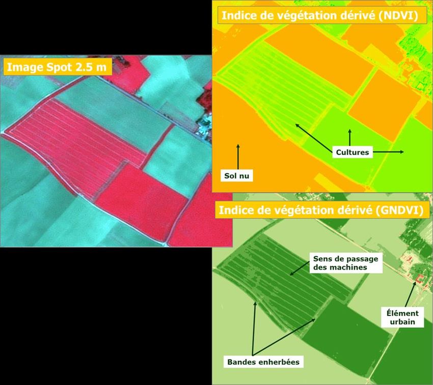
Airborne LiDAR applications
• Topographic Mapping:

     SECRÉTARIAT GÉNÉRAL
     Département de la Géomatique
     Direction de l’Intégration des géodonnées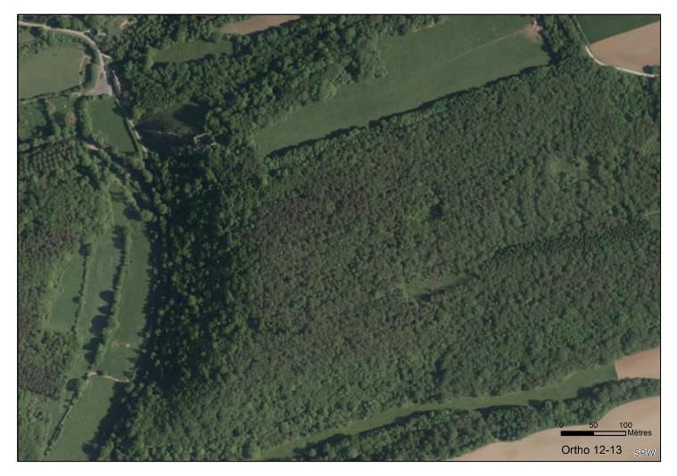
Airborne LiDAR applications
• Topographic Mapping & LCLU classification:

     SECRÉTARIAT GÉNÉRAL
     Département de la Géomatique
     Direction de l’Intégration des géodonnées
Airborne LiDAR applications
• Topographic Mapping: Slope, Aspect and Hillshade
SECRÉTARIAT GÉNÉRAL
Département de la Géomatique
Direction de l’Intégration des géodonnéesAirborne LiDAR applications
• Feature extraction in 3D
SECRÉTARIAT GÉNÉRAL
Département de la Géomatique
Direction de l’Intégration des géodonnéesAirborne LiDAR applications
• Mapping and Cartography : Underlying features appear with LiDAR
SECRÉTARIAT GÉNÉRAL
Département de la Géomatique
Direction de l’Intégration des géodonnéesAirborne LiDAR applications
SECRÉTARIAT GÉNÉRAL
Département de la Géomatique
Direction de l’Intégration des géodonnéesSatellite data
• Context:
– Potentially a complementary source of information to periodically
renew the orthoimage coverage.
– Possibility of cross-boundary acquisition => phenomenon are not
limited at regional boundaries.
– High level of accessibility (“return visit”) and flexibility
With the Sentinel, some images should be available 3 hours after the
acquisition, allowing almost time tracking / near real phenomenon.
– Mosaic and archive images with constant characteristics.
However for an annual regional coverage, we must accept a resolution
less constant (angle of view, cloud problems, dates of acquisition…)
SECRÉTARIAT GÉNÉRAL
Département de la Géomatique
Direction de l’Intégration des géodonnéesSatellite data
• Pléiades coverage:
– Thanks to Belspo (ORFEO Programme & recent test of a complete
national acquisition)
– First results: Pléiades is well suited for specific target areas and the
coverage of large areas is more sensible/uncertain
ORFEO Programme © CNES 2013, Distribution Astrium Services / Spot Image S.A., France, tous droits réservés,
Usage commercial interdit
SECRÉTARIAT GÉNÉRAL
Département de la Géomatique
Direction de l’Intégration des géodonnéesSatellite data
• EO data to support CAP:
• Control with Remote Sensing => operational
• Performed using Satellite Remote Sensing.
• Very High Resolution (VHR) Satellite Remote Sensing data are used for parcel
measurements.
• High Resolution (HR) SRS data are used to support the checks of land cover type or
checks of Cross Compliance
– Research : B-CGMS & SAGRIWATEL Projects
SECRÉTARIAT GÉNÉRAL
Département de la Géomatique
Direction de l’Intégration des géodonnéesSatellite data
• New opportunities
• Possible broad use cases:
‐ Detection / change detection
‐ LC & LU
‐ Crisis management / calamities
• SPW = « End users » of satellite applications and services, in main case
not a direct-end-user of satellite data.
‐ Belspo initiatives and research programs
‐ COPERNICUS & SPW-DGO6-SKYWIN
• Awareness of users and policy makers on the utility of satellite remote
sensing in public missions.
‐ Belspo research programs
‐ Strategic Plan for geomatics in Wallonia (PSGW 8/5/2014) POGW
SECRÉTARIAT GÉNÉRAL
Département de la Géomatique
Direction de l’Intégration des géodonnéesYou can also read