Residential Housing & Apartment Development on Zoned Lands at Crodaun, Celbridge, Co Kildare - ABP- 307100-20 - Celbridge Community Council
←
→
Page content transcription
If your browser does not render page correctly, please read the page content below
Residential Housing & Apartment
       Development on Zoned Lands at
        Crodaun, Celbridge, Co Kildare
               ABP- 307100-20

     Traffic & Transport Submission to
              An Bord Pleanála

Rev.         Status            Author(s)          Issue Date

 0            Draft             J. Walsh          12/06/2020

 1         Revised Draft        J. Walsh          17/062020

 2             Final       J. Walsh, T. Stronge   23/06/2020
Contents
1     INTRODUCTION                                                 1

2     TRAFFIC & TRANSPORT ISSUES                                   2

    2.1 Provision of Road and Transport Improvements               2
    2.2 Walking and Cycling Distances                              3
    2.3 Transport Management Plan and Public Transport Strategy    7
    2.4 Requirements of Traffic Impact Assessment                  8
    2.5 Traffic Survey Data                                        9
    2.6 Development Traffic Trip Distribution                      9
    2.7 Traffic Analysis                                          10
    2.8 Impact on Aghards Road Signalised Junction                12
    2.9 Pedestrian & Cycle Route along the R405 Maynooth Road     13
    2.10 Provision of Pedestrian/Cycle Route                      15
    2.11 Conformance with DMURS Design Standard                   15
    2.12 Road Safety Audit                                        16
    2.13 Permeability                                             17
    2.14 Western Link Road                                        18
3     CONCLUSION                                                  19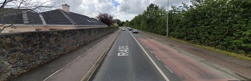
1       INTRODUCTION
This report has been prepared as part of a submission to An Bord Pleanála with regard to Residential
Housing & Apartment Development SHD application on Zoned Lands at Crodaun, Celbridge, Co Kildare
by Crodaun Development Company Ltd., ABP Reference: ABP- 307100-20.

Jason Walsh BE (Hons) CEng MIEI compiled this submission with support from members of Celbridge
Community Council’s Planning, Development & Transport Sub-Committee. Jason is a traffic and
transport engineer with 18 years’ experience in the industry. Jason is involved with the street design and
traffic related aspects of a number of SHD planning applications. Jason is also an TII approved Road
Safety Audit Team Leader and has experience in auditing development schemes.

A digital survey of residents was carried out by Celbridge Community Council to capture their views
about existing infrastructure and understand their views of the infrastructure impacts of a large scale
development such as this development. Data recorded in this survey has been interrogated and utilised
in the appropriate sections.

                                                  1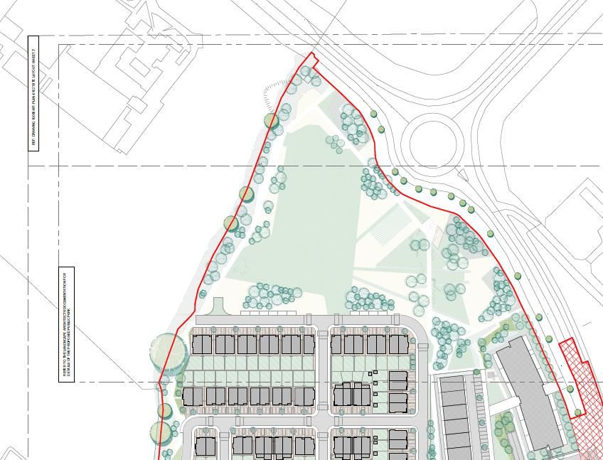
2        TRAFFIC & TRANSPORT ISSUES
The sections below highlights traffic and transport issues associated with the development.

2.1 Provision of Road and Transport Improvements

Development of Key Development Areas should be provided in tandem with road and transport
infrastructure improvements as noted in LAP Objective CSO1.2.

         CSO1.2: Support new residential developments in Key Development Areas (KDAs) in tandem with
         the delivery of supporting physical and social infrastructure.

The subject development site sits within Key Development Area 4 and is reliant on these infrastructure
improvements.

In relation to delivery of the road infrastructure improvements the most recent improvement to the
road network in Celbridge provided by Kildare County Council was the Upgrade of R405-Maynooth Rd /
Aghards Road junction in 2012.

In terms of public transport four additional 67X bus services were added to the timetable from Monday
25th November 2019.

The survey of residents in Celbridge has shown outstanding issues with the bus services on the
Maynooth Road even with the provision of the additional services noted above as shown. Figure 2.1
shows that bus service improvements will be required to support additional development in Celbridge.

Figure 2.1 – Main Issues encountered by Bus Users on Maynooth Road

Survey responses indicated overwhelmingly that traffic congestion is a serious issue for them as bus
users. This was closely followed by capacity and reliability issues. Survey respondents were able to
specify other issues and recurring themes relating to excessive journey lengths and inadequate
frequency of services are noted.

                                                        2                                        Rev 2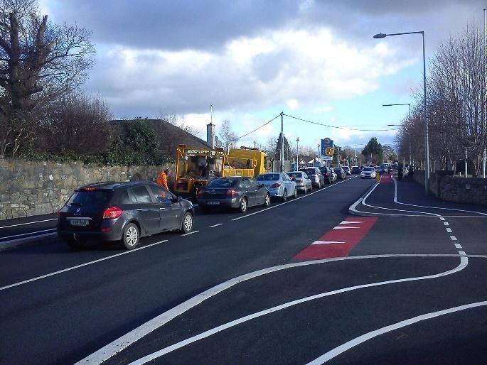
It is worth noting that the route of 67 bus service through Celbridge has no bus lanes and the service
shares the traffic lanes with the other vehicles, this means that the 67 bus service is highly susceptible to
congestion on the R405 Maynooth Road resulting in reliability issues.

Overall there is a lack of delivery of significant roads and transport infrastructure improvements in the
Celbridge area to support the addition of new large scale residential developments in Key Development
Area 4 and other the Key Development Areas in Celbridge.

2.2 Walking and Cycling Distances

New development should be focused in locations within walking and cycling distances of key locations as
noted in LAP Objective RDO1.4.

         RDO1.4: To focus the majority of new housing in Celbridge within walking or cycling distance of a
         school cluster, the town centre, neighbourhood centre or transport routes.

The distance from the proposed development to key locations within Celbridge is detailed in Table 2.1
below.
Table 2.1 – Key Location Distances

 Key Location                                                                 Icon          Distance
 Town Centre (Main Street)                                                                  2.1km
 Neighbourhood Centre (Castle Village)                                                      0.6km
 Supermarkets / Food stores                                                                 0.6-2.8km
 Bus Stops (to Dublin)                                                                      0.1km
 Bus Stops (from Dublin)                                                                    0.2km
 Rail Station – Leixlip Louisa Bridge                                                       4.1km
 Rail Station – Hazelhatch and Celbridge                                                    4.6km
 Salesian College - Secondary School                                                        500m
 Celbridge Community School - Secondary School – Temporary Location                         500m
 Celbridge Community School - Secondary School – Future Location                            2.9km
 St. Wolstan's Community School - Secondary School                                          3.0km
 Scoil Mochua - Primary School                                                              1.0km
 Scoil na Mainistreach - Primary School                                                     2.1km
 St Brigid’s Girls National School - Primary School                                         2.1km
 North Kildare Educate Together School - Primary School                                     3.5km
 Primrose Hill National School - Primary School                                             2.5km
 St. Patrick’s National School - Primary School – Temporary Location                        4.0km
 St. Patrick’s National School - Primary School – Future Location                           3.0km
 Sports Facilities / Playing Fields                                                         2.8-5.2km

The key locations listed in Table 2.1 are mapped in relation to the 5-minute interval walking and cycling
isochrones maps as detailed in Figure 2.2 & 2.3, respectively. (Journey times as per colour code below)

                                                    3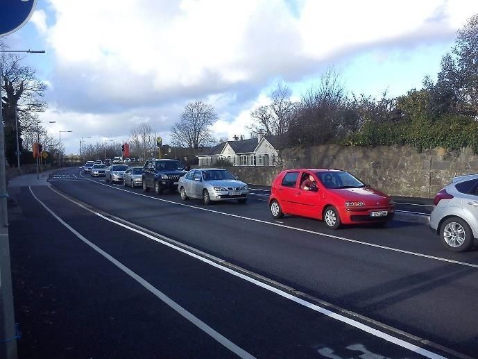
Figure 2.2 - Walking Isochrones – 5-minute intervals

One primary school, Scoil Mochua, is located within this distance and has traditionally been
oversubscribed. The other primary schools will have to cater to the development, and these are located
between 2.1-3.5km from the development.

Two secondary schools, Salesian College & Celbridge Community School, are located within this distance
however Celbridge Community School will be relocating to a permanent location 2.9km from the
development. The other secondary school, St. Wolstan's Community School, will have to cater to the
Development and is located 2.9km from the development. All female students will need to travel to
schools located at least 2.9km from the development after Celbridge Community School relocates.

The recommended comfortable walking distance to schools is 1km, a 15-minute walk; travel distance
above this will require other modes of transport, i.e. cycling or driving, to travel to the school locations.

The recommended walking distance to public transport is 500m, two bus stops are located inside this
range however the two train stations are 4.1km & 4.6km from the development and outside the
recommended walking distance and will require other modes of transport, i.e. cycling or driving, to
travel to their locations.

                                                       4                                              Rev 2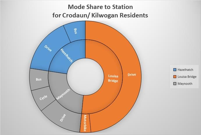
Figure 2.3 - Cycling Isochrones – 5-minute intervals

The majority of key locations are within a 15-minute cycle from the development. This cycle time is
acceptable for cycling to school, however not all schools are located on routes with safe cycle
infrastructure; routes to schools have only partial provision of cycle infrastructure and this provision is
often substandard (inadequate width, unsafe road crossings, etc). This lack of safe cycling infrastructure
will encourage driving as the transport mode to the school locations.

The two rail stations are marginally outside the 15-minute cycle time. The route to Leixlip Louisa Bridge
Rail Station from the development has cycling infrastructure. The route to Hazelhatch and Celbridge Rail
Station from the development has only partial provision of cycling infrastructure. The lack of safe cycling
infrastructure coupled with an unreliable shuttle bus service to Hazelhatch train station and the absence
of a shuttle bus service to Louisa Bridge train station will encourage driving as the transport mode.

Some details in relation to the Celbridge-Hazelhatch shuttle bus service are provided below:

    ●    6 shuttle bus services take passengers from Celbridge to the train station on weekdays - these
         feed 40% of the weekday trains leaving Hazelhatch for Dublin
    ●    9 shuttle bus services collect passengers from the train station on weekdays - these meet 34% of
         the weekday trains arriving at Hazelhatch from Dublin
    ●    No shuttle bus service runs at the weekend

The current mode share to the train stations taken from the survey of residents is detailed in Figure 2.4.
This shows that nearly 74% of rail users drive to the rail stations.

                                                       5
Figure 2.4 - Mode Share to Train Stations

Further, the mode share to train stations from only the Crodaun area taken from the survey of residents
is detailed in Figure 2.5.
Figure 2.5 - Mode Share to Train Stations from the Crodaun Area

This highlights that over half of all journeys to a train station from Crodaun are to Leixlip Louisa Bridge
and that the remainder are evenly split between Hazelhatch and Maynooth. Despite the applicant’s
belief that the “dedicated pedestrian route and cycle track” from the site to Louisa Bridge Train station
would be an attractive option for commuters, existing patterns of travel from the Crodaun area fail to
support this - no residents from this area of town walk to the train station and the only station to which
anyone cycles is Maynooth. The predominant mode of transport is by private car.

                                                          6                                         Rev 2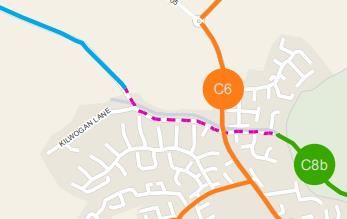
2.3 Transport Management Plan and Public Transport Strategy

A Transport Management Plan and Public Transport Strategy were supposed to be prepared within 12
months of the adoption of the Celbridge LAP as noted in LAP Objective MTO3.1.

          LAP Objective MTO3.1: To seek to prepare, within 12 months of the date of the adoption of the
          Celbridge Local Area Plan, a Transport Management Plan and Public Transport Strategy for
          Celbridge to support the sustainable growth and development of the town.

These documents were not generated within the 12 months period of the adoption of the LAP in 2017
and will most likely not be generated prior to the 2023 expiry of the LAP.

Lack of a transport plan with key timelines to provide key infrastructure and public transport
improvements impacts on the sustainable growth and development of the town. Approval of large-scale
developments in Celbridge without knowing these key timelines will have a detrimental impact on the
existing transport infrastructure and public transport service of the town.

An example of a location lacking an appropriate improvement plan is the narrow Liffey Bridge where all
of Main Street, English Row, the Dublin Road, the Hazelhatch Road and the Ardclough/ Newtown Road
converge. This bridge has poor footpath facilities and constrained carriageway widths leading to regular
occurrences of collisions between large vehicles as shown in Figure 2.6 below.

Figure 2.6 – Traffic Issue on Liffey Bridge

The statement outlined below by TII from their submission on the LAP is relevant in relation to the lack
of a Transport Management Plan.

          “While the TII acknowledges the requirement for a Traffic and Transport Assessment for all
          applications within the KDAs and the associated phasing requirements, they also state that this
          approach should not be taken as a substitute for undertaking a more strategic assessment of the
          capacity of the road network and its capacity to accommodate the extent of development
          proposed in the plan, which, the submission states, appears to be absent. The TII recommends
          that an evidence based transport assessment be undertaken to support development proposals
          and phasing set out for the KDAs.”

                                                   7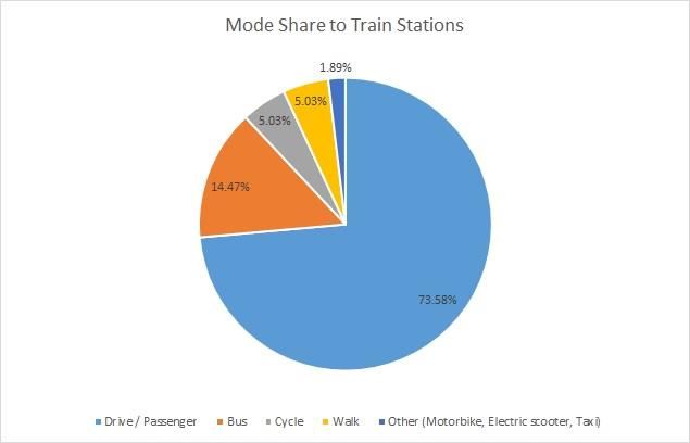
2.4 Requirements of Traffic Impact Assessment

The requirements of the Traffic Impact Assessment should be agreed with the Planning Authority,
Kildare County Council, as noted in LAP Objective MTO3.6

         LAP Objective MTO3.6: To ensure that all significant development proposals for the KDAs are
         subject to a Traffic Impact Assessment (TIA), to be carried out in accordance with the Traffic and
         Transport Assessment Guidelines, NRA (2014). The requirement for TIA will be determined, by
         the Planning Authority, on a case-by-case basis.

A review of the NRB Transportation Assessment Report hasn’t detailed any agreement of the
requirements of the Traffic Impact Assessment with Kildare County Council. As noted within the Traffic
and Transport Assessment Guidelines, NRA 2014 these requirements should form an agreed scoping
study document. This scoping study document would normally be provided as an appendix to the Traffic
Impact Assessment report.

Appropriate scoping of the Traffic Impact Assessment would most likely have included additional
junctions within the assessment, the Aghards Road signalised junction and Shackleton Road signalised
junction are two keys junctions that should have been included. The Aghards Road signalised junction
and Shackleton Road signalised junction are significant junctions in Celbridge Town and the lack of
inclusion of these junctions fails to detail the development traffic impacts on these junctions.

The Celbridge River Crossing Feasibility Report carried out in May 2015 included an assessment of the
Shackleton Road signalised junction, this analysis showed two arms of this junction operating close to
capacity in 2019. Additional development traffic would most likely push this junction over capacity.

The survey of residents provided information on driver delay in minutes experienced by drivers at
Aghard’s Road and Shackleton Road signalised junctions. Figures 2.7 & 2.8 show the average delay
experienced at these junctions in the mornings.

Figure 2.7 – Delay at Aghard’s Road Signalised Junction (AM)

                                                           8                                       Rev 2
Figure 2.8 – Delay at Shackleton Road Signalised Junction (AM)
These delays confirm that these junctions are operating close to capacity at peak times which will be
further exacerbated with the addition of development traffic.
2.5 Traffic Survey Data
No details are provided for the day and date of the 2019 traffic survey data used in the NRB
Transportation Assessment Report submitted as part of the application. Traffic surveys should be carried
out as recommended by Traffic & Transport Assessment Guidelines, NRA 2014 and will need to identify
the development trip impacts during the peak periods for the local network. In general terms the peak
periods for the local network are;
● Midweek – Tuesday to Thursdays
● Outside of School Holiday Periods
It is difficult to ascertain if the 2019 traffic survey data used in the NRB Transportation Assessment
report complied with the above requirements.
The use of traffic survey data carried out during an inappropriate period would lead to flawed analysis of
the traffic impacts of the development.
2.6 Development Traffic Trip Distribution
Appendix C of the NRB Transportation Assessment report shows that the development traffic has been
assigned to the surrounding road network based on the percentages below:
● AM Departure – 71% to Maynooth Road (North) & 29% to Maynooth Road (South)
● AM Arrival – 75% from Maynooth Road (North) & 25% from Maynooth Road (South)
● PM Departure – 65% to Maynooth Road (North) & 35% to Maynooth Road (South)
● PM Arrival – 75% from Maynooth Road (North) & 25% from Maynooth Road (South)
To determine a more accurate trip distribution for a residential development in the Crodaun area the
traffic counts at the Crodaun Forest Park Phase 1 access junction, provided within the NRB
Transportation Assessment report, have been reviewed to determine the traffic distribution below:
● AM Departure – 53% to Maynooth Road (North) & 47% to Maynooth Road (South)
9● AM Arrival – 50% from Maynooth Road (North) & 50% from Maynooth Road (South)
● PM Departure – 38% to Maynooth Road (North) & 62% to Maynooth Road (South)
● PM Arrival – 42% from Maynooth Road (North) & 58% from Maynooth Road (South)
If the trip distribution above was assigned to the development, it would have provided a more accurate
assessment of the distribution of the traffic to and from the proposed development. The distribution
detailed above also shows a clear attraction of traffic to/from the Maynooth Road (South) direction
towards Celbridge town. This attraction of traffic towards Celbridge town is in line with the position of
key locations to the south of the development as detailed in Section 2.2.
The NRB Transportation Assessment is lacking a robust and accurate trip distribution assessment for the
proposed development and fails to account for the attraction of development traffic to/from the
Maynooth Road (South).
2.7 Traffic Analysis
The NRB Transportation Assessment report failed to address the development traffic impacts of the
Crodaun Forest Park Phase 2 access junction and only checked the impact on the Crodaun Forest Park
Phase 1 & Kilwogan Lane junction. Crodaun Forest Phase 2 is the larger of the two development phases
with 229 houses as compared to 69 houses in Phase 1.
The survey of residents in Celbridge provided the delays experienced at the main access junctions onto
the R405 Maynooth Road. The average delay experienced at these junctions in the mornings is provided
in Figure 2.9 with the delays experienced at the neighbouring residential junction, Crodaun Forest Phase
1 and Crodaun Forest Phase 2 detailed in Figures 2.10 & 2.11
Figure 2.9 - Average Delay at Junctions (AM)
10 Rev 2Figure 2.10 - Crodaun Forest Phase 1 Delay at Junctions (AM)
Figure 2.11 - Crodaun Forest Phase 2 Delay at Junctions (AM)
It is clear from the figures above that residents in both the Crodaun Forest Phase 1 and Phase 2
developments are suffering significant delays when accessing the R405 Maynooth during peak times.
Figure 2.12 shows the mainline traffic on the R405 Maynooth Road in the afternoon in the vicinity of the
Crodaun Forest development.
Figure 2.12 - Traffic on R405 Maynooth Road
11The NRB Transportation Assessment report fails to account for these existing delays in the traffic
assessment of the Crodaun Forest Park (Phase 1) access junction, the analysis carried out with
development traffic applied doesn’t accurately model the impact on this junction and the increased
delays due to the development traffic.
The traffic modelling NRB Transportation Assessment hasn’t been accurately set up to account for
exiting traffic situations and hasn’t provided an accurate assessment of development traffic impacts.
2.8 Impact on Aghards Road Signalised Junction
As noted in Section 2.4, the Aghards Road Signalised Junction is a key junction in Celbridge. Based on the
revised development traffic trip distribution detailed in Section 2.8, the Aghards Road Signalised
Junction should have been assessed for development traffic impacts.
In order to determine the development traffic impacts on the Aghards Road Signalised Junction, a high-
level assessment of the development traffic impacts was completed using the traffic count data from
the granted Castlewellan Park Development, Planning reference 16260. This traffic count was carried
out in 2016 and is recent enough for the purpose of a high-level assessment.
This assessment is detailed in Tables 2.3 and 2.4. Table 2.3 details the impact of development traffic
from this SHD application, ABP- 307100-20 (Crodaun). Table 2.4 details the combined impact of
development traffic from the two adjacent SDH applications, ABP- 307100-20 (Crodaun) & ABP-306504-
20 (Ardstone).
Table 2.3 - ABP- 307100-20 Development Traffic Impacts
Southbound Northbound Traffic Southbound Northbound Traffic
Traffic from from Junction to Traffic from from Junction to
Development to Development - AM Development to Development - PM
Junction - AM Junction - PM
Mainline Traffic 584 1002 864 560
(R405 Maynooth
Road)
Development Traffic 74 38 58 93
(ABP- 307100-20)
Percentage Increase 13% 4% 7% 17%
Table 2.4 - ABP- 307100-20 & ABP-306504-20 Development Traffic Impacts
Southbound Northbound Traffic Southbound Northbound Traffic
Traffic from from Junction to Traffic from from Junction to
Development to Development - AM Development to Development - PM
Junction - AM Junction - PM
Mainline Traffic 584 1002 864 560
(R405 Maynooth
Road)
Development Traffic 132 58 98 166
(ABP- 307100-20 &
ABP-306504-20)
Percentage Increase 23% 6% 11% 30%
12 Rev 2The Traffic & Transport Assessment Guidelines, NRA 2014 note that the threshold for sensitive locations
is 5%, the Aghards Road Signalised Junction would be considered a sensitive junction in relation to traffic
for the town of Celbridge.
From Table 2.3 and Table 2.4, the average percentage increase is 11% for this application’s development
traffic and 18% for the development traffic for the combined development traffic from the two
applications.
The percentage increase is well above the 5% threshold and demonstrates that the Aghards Road
Signalised Junction should have been included in the traffic assessment for this application.
A similar analysis if carried out on the Shackleton road Signalised Junction would most likely show
similar impacts.
2.9 Pedestrian & Cycle Route along the R405 Maynooth Road
The R405 Maynooth Road fronting the development is heavily used as a pedestrian and cyclist route for
students of the two secondary schools, Salesian College and Celbridge Community School, both situated
to the north of the R405-R449 roundabout. The combined number of students enrolled between the
secondary schools in 2020-21 is expected to be 1455, 705 for Salesian College & 750 for Celbridge
Community School.
Figure 2.13 provides information on mode share for education trips in Kildare towns including Celbridge
from the Leixlip LAP Strategic Transport Assessment.
Figure 2.13 - Leixlip LAP Education Mode Share
This figure shows Celbridge having the highest mode share for students cycling to school compared to
the other towns. This is backed up by the Census 2016 data which shows Celbridge is 3rd for primary
school students cycling to school and 1st for secondary students cycling to school. This is detailed in
Figure 2.14 below.
13Figure 2.14 – Census 2016 Cycling Data
The Kildare Bicycle Account carried out by Kildare County Council in 2013 showed Salesians College
standing out with a cycling percentage of 21.6%. Celbridge Community School wasn’t in place when this
report was undertaken but based on observations, the cycling percentage for Celbridge Community
School is also high.
At peak times, the number of students cycling along the R405 Maynooth Road is close to 300 and the
number of students walking along the R405 is significantly more. The recommended width for this level
of cyclists based on advice in the National Cycle Manual would be 2.0 to 2.5m.
The footpath and cycle facilities along this route are substandard for this level of peak time activity,
existing footpaths are 1.5m wide and existing cycle paths are 1.5m wide for one-way paths and 3.0m
wide for two-way paths. No segregation exists between the footpath and cycle path leading to
pedestrian and cyclist conflicts along this route.
The development has not proposed any upgrade to these facilities. Figure 12.3 (Design Concept for KDA
4 Crodaun) from the LAP proposes a segregated pedestrian and cycle route to be provided in an open
space landscaped buffer to the Maynooth Road. Due to the increased pedestrian and cyclists’ number
that the development would add to the existing road network, proposals to improve these facilities
should have been incorporated as part of the development.
It is worth noting that the Kildare Transport Report included in the Chief Executives report to An Bord
Pleanála for the adjacent SHD application, Ref ABP-306504-20, noted that the development should
include upgrade of the substandard footpath and cycle paths along the entire frontage of their
boundary.
The development should have included an upgrade of the footpath and cycle paths along the frontage
of the development, the widths of the footpath and cycle paths should be provided in line with the
recommended widths for the high level of activity. Segregation between the cycle path and footpath
should be incorporated to improve safety for the users.
14 Rev 22.10 Provision of Pedestrian/Cycle Route
In accordance with LAP Objective MTO1.2 noted below, the development should facilitate the provision
of routes identified in the Greater Dublin Area Cycle Network Plan.
LAP Objective MTO1.2: To facilitate and encourage cycle as a more convenient and safe method
of transport through the development of new or improved cycle facilities in Celbridge with a
particular focus on the routes identified in the National Transport Authority (NTA) Greater Dublin
Area Cycle Network Plan to link population, commercial, community facilities, schools and
transport nodes. Any new development to facilitate routes identified in the Greater Dublin Area
Cycle Network Plan shall be subject to the mitigation detailed in the environmental assessments
for that plan.
Sheet N16 of the Greater Dublin Area Cycle Network Plan details a feeder route along Kilwogan Lane,
this route is also highlighted on the Map 8.1 of the LAP. These are detailed in Figure 2.15 below.
Figure 2.15 - Proposed Western Link Road Alignment
Greater Dublin Area Cycle Network Plan Sheet N16 LAP Map 8.1
The An Bord Pleanála Inspector’s report on the 302887-18 Strategic Housing Development consultation
notes that Kildare County Council were seeking "Provision of pedestrian/cycle route along Kilwogan
Lane or within subject site as per Celbridge LAP and indicated on map 8.1 of same".
The proposed development has not facilitated the provision of this cycle route within the site or along
Kilwogan Lane.
2.11 Conformance with DMURS Design Standard
In accordance with LAP Objective MTO3.8 noted below the development should comply with the Design
Manual for Urban Roads and Streets (DMURS).
LAP Objective MTO3.8: To require all new developments to comply with the recommendations of
the Design Manual for Urban Roads and Streets (DMURS) and National Cycle Manual, or any
subsequent relevant publication.
The NRB DMURS Statement of Consistency submitted with the application details the provision of a
single street hierarchy, a local street with a 6.0m carriageway width.
15This street width is greater than the 5.0-5.5m recommended local street width noted in section 4.4.1 of
DMURS. The provision of local streets above the recommended width will promote higher traffic speeds
and be difficult to achieve a 30km/hr self-regulating development street network.
The NRB DMURS Statement of Consistency notes the provision of 6m junction radii, the engineering
drawings submitted as part of the application do not detail the junction radii at the individual junction
so it can only be assumed that 6m has been applied to all junctions within the development. DMURS
section 4.3.3 recommends 3-4.5m junction radii for local street junctions, this would apply to the
internal development junction. The provision of junction radii above the recommended radii for local
street junction will promote higher traffic speeds and be difficult to achieve a 30km/hr self-regulating
development street network.
DMURS Advice Note 4 (May 2019) looks for a DMURS Street Design Audit to be carried out on
developments of this scale. No Street Design Audit was submitted as part of the planning application. A
Street Design Audit if carried out would have picked up the issues outlined above and would have
assessed the full DMURS requirements.
The internal street layout of the development fails to provide a safe low speed environment for the safe
integration of vehicles, cyclists and pedestrians.
2.12 Road Safety Audit
The submitted Stage 1 Road Safety Audit (report ref 0704R01-Rev 3) carried out by Bruton Consulting
Engineers on behalf of NRB has noted just 1 item with respect to the proposed development. For a
development of this scale a larger number of safety issues would be expected to be raised. Notably the
audit has not raised any safety issues on the existing road network fronting the development.
Figure 2.16 R405 adjacent to Development Site. (Note the narrow cycle & foot path)
A safety review of the existing road network fronting the development has been carried out. The safety
issues below were noted as part of this review.
1. Footpath Width – the footpath width is too narrow for the high level of pedestrian numbers at
busy times. Inadequate footpath width forces pedestrians to walk in the adjacent cycle path in
conflict with cyclists. The footpath should be increased in width to cater for the pedestrian
demand at busy times. This is noted in the Kildare Transport Report included in the Chief
Executives report to An Bord Pleanála for the adjacent SHD application, Ref ABP-306504-20.
2. Cycle Path Width – the cycle path width is too narrow for the high level of cyclists’ numbers at
busy times, inadequate cycle path width forces cyclists to cycle in the adjacent footpath in
conflict with pedestrians. The cycle path should be increased in width to cater for the cyclist
16 Rev 2demand at busy times. This is noted in the Kildare Transport Report included in the Chief
Executives report to An Bord Pleanála for the adjacent SHD application, Ref ABP- 307100-20.
3. Segregation between Footpath and Cycle Path – no segregation is provided between the
footpath and cycle path to discourage cyclists from using the footpath and vice versa as noted
above. Segregation should be provided between the footpath and cycle path to improve safety
for the users.
4. Bus Stop Layout – buses pick up and drop off passengers directly on the cycle path, this places
passengers in conflict with cyclists. Passengers waiting for the bus will block the footpath path
forcing pedestrians onto the cycle path. The bus stop layout should be improved to remove the
conflict between passengers and pedestrians and cyclists. This is noted in the Kildare Transport
Report included in the Chief Executives report to An Bord Pleanála for the adjacent SHD
application, Ref ABP-306504-20.
5. Crossing Facility – the signalised toucan crossing on the R405 Maynooth Road has a poor layout
and prioritises cyclists, placing pedestrians in conflict with cyclists when accessing the crossing.
The crossing should be improved to provide a safer crossing for pedestrians and encourage safer
use by cyclists.
6. Development Access Junctions Layout – the development access junctions as proposed as
simple priority junctions, the level of traffic on the R405 Maynooth Road at peak times will
result in traffic turning right into the development having to wait for a gap to enter the
development and blocking traffic on the main line. Drivers may feel pressured to take hasty
manoeuvres resulting in vehicle collisions.
7. Junction Visibility at Kilwogan Lane – junction visibility to the right is obscured by an existing
boundary wall resulting in poor visibility for right turning vehicles. This wall should be setback to
improve visibility.
8. Cyclist Numbers at Peak Times – cyclists at peak times are observed to be cycling in the
footpath, this is due to narrow widths of the cycle path and the lack of segregation between the
footpath and cycle path. An appropriate width cycle path should be provided.
Given the number of safety issues noted above in relation to the existing road network it would be
appropriate that the Stage 1 Road Safety Audit submitted with the application is deemed flawed and
severely lacking.
2.13 Permeability
LAP Objective MTO1.8 notes the requirement to deliver or provide for filtered or full permeability as
detailed below.
LAP Objective MTO1.8: To require new housing developments to deliver filtered or full
permeability to adjoining development in so far as is possible and, in the case of adjoining
greenfield sites, to ensure the potential for such provision is addressed.
Drawing 19080-SIT-PLAN-0008 submitted as part of the planning application details proposed
connection points onto Kilwogan Lane and into the adjoining green field land. However, these
connections haven’t been provided to the site boundary which may lead to difficulty with making these
connections in the future.
The development should provide these connections to the site boundary to allow a future developer of
the adjoining land to make these connections and the council to provide the connection to Kilwogan
Lane.
172.14 Western Link Road
LAP Objective MTO3.11 notes the potential for a Western Link Road to the R405 Maynooth Road as
follows:
LAP Objective MTO3.11: To explore by way of Feasibility Study the potential to construct a
Western Link Road that will link Maynooth Road R405 with the Clane Road R403
Figure 12.3 of the LAP Design Concept for Key Development Area 4 details a route for the Western Link
Road, this route runs through Zone F zoned for Open Space and Amenity area. The development has
noted this area as a natural ecological park. It is unclear from the application if the natural ecological
park has been designed with the potential for the future road link to be provided through it.
The requirement for a western link road is a very probable outcome from the feasibility study to explore
the potential to construct a Western Link Road and from the delayed transport strategy for Celbridge.
The layout of the proposed development jeopardises the future delivery of a Western Link Road as the
provision for a park is squeezed further north west into land that would be needed for this road. The site
layout detailing the western link road alignment from LAP Figure 12.3 Design Concept for KDA 4 is
detailed below.
Figure 2.16 - Proposed Western Link Road Alignment
The design of the natural ecological park and the north-western corner of the housing development
should be evaluated in relation to the future provision of a link road and a potential design submitted
for its operation with the road link in place.
18 Rev 23 CONCLUSION
Based on the points noted above it is clear that the application is lacking in a number of areas chiefly,
traffic assessment, conformance with DMURS standards, compliance with LAP Objectives and road
safety.
It would be appropriate to refuse permission to this SHD application based on the items noted in Section
2 of this report as many of these are too significant to address in planning conditions alone and may
require significant redesign of the development to address them.
19You can also read