Residential Travel Plan Report Project: 20.133 Carriglea Residential Development Phase 2, Muirfield Drive, Naas Road, Dublin 12
←
→
Page content transcription
If your browser does not render page correctly, please read the page content below

Residential Travel Plan Report

                                  Project: 20.133

                                  Carriglea Residential
                                  Development Phase 2,
                                  Muirfield Drive, Naas
                                  Road, Dublin 12

SD06.RL/Rev0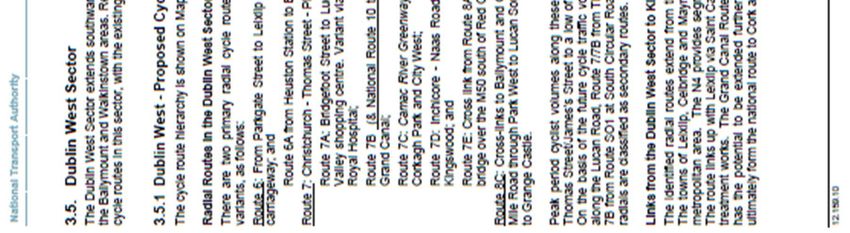
Document No.:           20.133-RTP-01                        Page   1    of   43

Document History

Project                  Carriglea Residential Development Phase 2

Project No.              20.133

Document Title           Residential Travel Plan Report

Document No.             20.133 - RTP – 01

  Issue        Date               Description         Orig.          PE             Issue Check

  PL 1    18.02.2021         Issued for Planning      MR             YM               JCu

  PL 2    03.03.2021         Issued for Planning      MR             YM               JCu

  PL 3    20.09.2021         Issued for Planning      MR             EH               JCu

  PL 4    23.09.2021         Issued for Planning      MR             EH               JCu

Contact Information
Barrett Mahony Consulting Engineers Ltd
52-54 Lower Sandwith Street, Dublin 2
D02 WR26

Telephone: 01 677 3200
Email: bmce@bmce.ie

www.bmce.ie

SD06.RL/Rev0
Document No.:           20.133-RTP-01                         Page    2   of   43

CONTENTS

1.     INTRODUCTION
       1.1        PROJECT OVERVIEW
       1.2        SCOPE OF THIS REPORT
2.   SUSTAINABILITY OF CAR PARKING PROVISION AT THE PROPOSED
DEVELOPMENT
       2.1        INTRODUCTION
       2.2        CAR AND CYCLE PARKING REQUIREMENTS AS PER DUBLIN CITY DEVELOPMENT
                  PLAN
       2.3        CAR AND CYCLE PARKING PROVISION
       2.4        CAR PARKING REQUIREMENTS FOR THE RESIDENTIAL DEVELOPMENT BASED ON
                  THE NEW APPARTMENT GUIDELINES
       2.5        PROJECTED CAR USAGE IN GENERAL PROXIMITY TO PROPOSED DEVELOPMENT
       2.6        MODAL SPLITS FOR THE PRIVATE CAR - 2017 CANAL CORDON COUNTS DOCUMENT
       2.7        MODAL SPLIT FOR THE PRIVATE CAR – 2016 CENSUS RESULTS FOR ELECTORAL
                  DISTRICTS IN THE VICINITY OF THE PROPOSED DEVELOPMENT
       2.8        CONCLUDING COMMENT
3.     GUIDANCE AND POLICY DOCUMENTS ON RESIDENTIAL TRAVEL PLANS
       3.1        INTRODUCTION
       3.2        NATIONAL / INTERNATIONAL / LOCAL POLICY ON SUSTAINABLE TRAVEL / TRAVEL
                  PLANS
             3.2.1 SMARTER TRAVEL, A SUSTAINABLE TRANSPORT FUTURE (STASTF) – A NEW
             TRANSPORT POLICY FOR IRELAND, 2009 – 2020
             3.2.2 GREATER DUBLIN AREA TRANSPORT STRATEGY, 2016-2023
             3.2.3 DUBLIN CITY COUNCIL DEVELOPMENT PLAN, 2016-2022
             3.2.4 MAKING RESIDENTIAL TRAVEL PLANS WORK: GUIDELINES FOR NEW DEVELOPMENT
             - UK DEPARTMENT OF TRANSPORT, 2005
4.    THE TRAVEL PLAN PYRAMID
5.    THE CONTENTS OF RESIDENTIAL TRAVEL PLAN
6.    ROAD NETWORK, AND EXISTING PUBLIC TRANSPORT AND CYCLING
FACILITIES
       6.1        SITE LOCATION
       6.2        EXISTING PUBLIC TRANSPORT INFRASTRUCTURE
       6.3        EXISTING CYCLING PROVISION

7.     PREDICTED POST-DEVELOPMENT TRAVEL PATTERNS
       7.1        INTRODUCTION
       7.2        FUTURE PLANNED PUBLIC TRANSPORT AND CYCLING NETWORK IMPROVEMENTS

SD06.RL/Rev0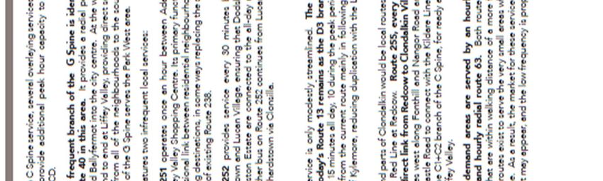
Document No.:           20.133-RTP-01                         Page   3   of   43

             7.2.1 BUS CONNECTS
             7.2.2 GDA CYCLE PLAN
8.     OBJECTIVES OF TRAVEL PLAN STRATEGY
       8.1        INTRODUCTION
       8.2        OBJECTIVE NO. 1 - MANAGE PRIVATE CAR AVAILABILITY FOR RESIDENTS (WORK
                  AND NON-WORK PURPOSES)
       8.3        OBJECTIVE NO. 2 - ENCOURAGING GREATER USE OF PUBLIC TRANSPORT FOR THE
                  JOURNEY TO WORK
             8.3.1 GENERAL
             8.3.2 PUBLIC TRANSPORT INFORMATION
       8.4        OBJECTIVE NO. 3 - ENCOURAGING MORE RESIDENTS TO CYCLE TO WORK
       8.5        OBJECTIVE NO. 4 - ENCOURAGING MORE RESIDENTS TO WALK TO WORK

9.   ROLE OF THE TRAVEL PLAN COORDINATOR FOR THE PROPOSED
RESIDENTIAL DEVELOPMENT
       9.1        APPOINTMENT OF TRAVEL PLAN COORDINATOR
       9.2        DUTIES OF THE TRAVEL PLAN CO-ORDINATOR
             9.2.1 PROMOTING THE ENVIRONMENTAL AND HEALTH BENEFITS OF THEIR TRAVEL
             CHOICES
             9.2.2 PROMOTING BIKE USE
             9.2.3 PROMOTING WALKING TO WORK
             9.2.4 PROMOTING RAIL AND BUS BASED TRAVEL
             9.2.5 MONITORING THE MODAL SPLITS FOR THE RESIDENTS’ JOURNEY TO WORK
10.    CONCLUDING COMMENT

SD06.RL/Rev0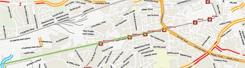
Document No.: 20.133-RTP-01 Page 4 of 43
1. INTRODUCTION
1.1 PROJECT OVERVIEW
Golden Port Estate Ltd has commissioned Barrett Mahony Consulting Engineers (BMCE) to prepare a
Residential Travel Plan Report for phase 2 of the proposed residential development at Carriglea
Industrial Estate, Muirfield Drive, Naas Road, Dublin 12.
The proposed development will consist of:
The construction of a residential development of 249 no. apartments (2 no. studios, 59 no.
one bedroom, 153 no. two bedroom; and 35 no. three bedroom) in eight 5 to 8 storey blocks
comprising:
o a total of 38 no. apartments (10 no. one bedroom, 21 no. two bedroom and 7 no. three
bedroom units in 8 storey Block D;
o a total of 46 no. apartments (13 no. one bedroom, 20 no. two bedroom and 13 no. three
bedroom) in 8 storey Block E;
o a total of 24 no. apartments (5 no. one bedroom and 11 no. two bedroom and 8 no. three
bedroom) in 5 storey Block F;
o a total of 25 no. apartments (10 no. one bedroom and 15 no. two bedroom) in 5 storey
Block G;
o a total of 24 no. apartments (1 no. studio, 7 no. one bedroom and 16 no. two bedroom)
in 5 storey Block H;
o a total of 24 no. apartments (1 no. studio, 7 no. one bedroom and 16 no. two bedroom)
in 5 storey Block J;
o a total of 22 no. apartments (6 no. one bedroom and 16 no. two bedroom) in 5 storey
Block K;
o a total of 46 no. apartments (1 no. one bedroom, 38 no. two bedroom and 7 no. three
bedroom) in 8 storey Block L;
The provision of ancillary on-site facilities including a 149 sq. m. meeting space and 173 sq.
m. community facility on the ground floor level of Block E; a 155 sq. m. café and 140 sq. m.
Digital Hub on the ground floor level of Block F; and a 92 sq. m. resident’s concierge facility
on the ground level of Block L;
The construction of a lower ground level car park providing 185 no. car parking spaces
including 10 no. universal access spaces and 10 no. club cars spaces, 20 no. electric car
charging spaces (note 2 no. accessible spaces are EV) 554 no. cycle parking spaces (including
18 no. electric bicycle charging spaces), service and plant areas, waste management areas
and storage areas.
The extension of the vehicular access on the site across a shared landscaped surface to access
the revised entrance point to the lower ground level car park, the provision of pedestrian and
cyclist route accesses to the adjacent residential developments to the east and north west,
to Lansdowne Gate to the south and Naas Road to the north
The provision of communal landscaped open space at podium level; a viewing area at the
northern end of the linear park incorporating a raised platform with seating areas and feature
SD06.RL/Rev0
Document No.: 20.133-RTP-01 Page 5 of 43
textile tensile structure with metal frame; and a play area with equipment in the south east
corner of the site; and
All other associated works required to facilitate the proposed development including the
paving of and landscaping of footpaths and internal roads; the provision of 2 no. set down car
spaces; 70 no. surface cycle parking spaces; and the provision of solar PV panels on the roofs
of the apartment blocks.
For the purposes of this residential travel plan report, we note that the overall development,
comprising both phase 1 and 2, will comprise 393 no. apartments, 185 no. car parking spaces, 6 set-
down spaces adjacent to the creche in phase 1, 2 visitor set-down spaces in phase 2 and a total of 781
no. bicycle parking spaces.
1.2 SCOPE OF THIS REPORT
The purpose of this report is as follows:
Propose the rationale for a reduced car parking provision for the residential development, and
demonstrate that the proposed provision is entirely sustainable given the current car ownership
and modal splits for the journey to work for existing residents living close to the subject site.
Given this reduced parking provision, demonstrate the sustainability in transportation terms of
residents utilizing non-car-based forms of travel by demonstrating the high level of service that
is provided by the transport infrastructure in place at the site with regards to, walking, cycling,
public bus services, DART, national rail, and other Services.
Identify both physical elements and strategies to be incorporated within the proposed new
development which will facilitate and create incentives for both residents of and visitors to the
development, to use the available modes of public transport, along with walking and cycling in
preference over private car use.
Provide a residential travel plan framework to help ensure projected modal splits for the
development are maintained / improved, with the appointment of a travel plan coordinator to
oversee the process.
We note that elements of the current application will have the effect of amending a number of
previous planning permissions granted for the residential development on the site – previous Dublin
City Council planning references 4244/15, 2438/17, 2875/17, 3940/17, 2176/18, 2203/18 and
2319/18. The changes relate to phase 2 of the development involving blocks D through to L. The
proposal is to omit the permitted underground basement carpark level and introduce parking and
some accommodation at a lower ground floor level, with the previously permitted courtyard and
accommodation moving from ground level to a proposed podium level.
The proposed residential units at ground level will result in an additional 22 no. units on the overall
site increasing the total from 371 no. to 393 no.
In terms of the traffic impact of the proposed submission relative to the permitted development, the
following alterations apply:
Increase in the number of residential units from 371 No. to 393 No.
Decrease in the number of car parking spaces for the residential component from 260 No. to
185 No. (145 no. basic spaces, 10 no. car club spaces and 10 no. universal spaces, 20 No.
electric vehicle charging spaces).
SD06.RL/Rev0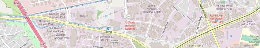
Document No.: 20.133-RTP-01 Page 6 of 43
Increase in cycle parking spaces from 594 No. to 781No.
Section 2 of this report will estimate the car and cycle parking requirement for the overall
development, proposing that, for the commercial component, full effective compliance with the car
and cycle parking requirements will be achieved. For the residential component, while the full cycle
parking requirements will be achieved, a restricted car parking provision will be proposed. The
sustainability of this level of car parking provision will be demonstrated using census and canal cordon
survey data.
Section 3 details the relevant guidance documents on mobility management planning in Ireland.
Sections 4 to 9 contain the residential travel plan for the proposed development, utilizing the modal
splits derived within Section 2.
Section 10 makes some overall concluding comments.
The site is located on the southern side of the Naas Road, within the Carriglea Industrial Estate,
approximately 450 metres east of the Naas Road / Kylemore Road / Walkinstown Avenue signalized
intersection. Figure 1-1 provides a location map for the proposed development.
The proposed development will consist of 393 no. dwelling units. It is proposed to provide 185 No. car
parking spaces, equating 0.47 No. car parking spaces per apartment, and 781 No. cycle parking spaces.
The development mix is as follows:
2No. Studios
97 No. 1-Bed Apartments
240 No. 2-Bed Apartments
54 No. 3-Bed Apartments
530 m2 GFA crèche
The report will justify the relatively limited on-site parking on the basis of:
Coherence with the parking requirements as stated within the New Apartment Guidelines;
The travel patterns for existing commuters in the area as detailed within the 2016 Census for
their journey to work;
The existence of significant non-car-based travel alternatives for residents at the proposed
development.
SD06.RL/Rev0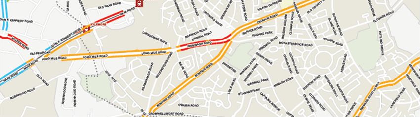
Document No.:                  20.133-RTP-01                        Page   7   of   43

Figure 1-1: Location of site within local road network

It will be assumed within this report that the proposed development will open in 2023.

Appendix 1 contains a site layout of the proposed development.

SD06.RL/Rev0
Document No.:                20.133-RTP-01                                      Page    8    of    43

2. SUSTAINABILITY OF CAR PARKING PROVISION AT THE PROPOSED DEVELOPMENT

2.1 INTRODUCTION

This section details the car and cycle parking requirements under the Dublin City Development Plan.
While the proposal will provide almost 200% of the required cycle parking, a car parking provision of
0.47 spaces per residential unit is proposed. The rationale for this reduced level of car parking
provision is based on the requirements of the New Apartment Guidelines and the analysis of census
information for the local area. It will be demonstrated that the proposed residential parking provision
is entirely sustainable given the current car ownership and modal splits for the journey to work /
college for existing residents living close to the subject site.

This reduced level of car parking provision is also seen as being completely consistent with the mobility
targets for the greater Dublin area as detailed within the Dublin City Transport Plan and also consistent
both with minimizing the traffic impact of the proposal and with maximizing patronage of the
extensive public transport and soft mode options (as detailed within this mobility plan).

2.2 CAR AND CYCLE PARKING REQUIREMENTS AS PER DUBLIN CITY DEVELOPMENT PLAN

Tables 2-1 and 2-2 below detail the maximum car and bicycle parking standards for Dublin City Council
based on the rates contained within their 2016 - 2022 Development Plan Written Statement for the
residential and crèche components of the proposed development respectively (located within Zone 2
of Map set J):

 Development type        Area /         Maximum car parking standards         Maximum parking required
                         units
 Apartments              393 No.        1.0 per unit                          393

                                        Bike parking standards                Parking required
 Apartments              393 No.        1 per unit                            393
Table 2-1: Parking required under Dublin City Council Development Plan Standards for residential component

 Development type        Area /         Maximum car parking standards           Maximum parking
                         units                                                  required
 Crèche                  530 m2         1 per 200 m2 plus 2 drop off            6

                                        Bike parking standards                  Parking required
 Creche                  530 m2         -                                       -
Table 2-2: Parking required under Dublin City Council Development Plan Standards for crèche component

2.3 CAR AND CYCLE PARKING PROVISION

In terms of car parking provision, it is proposed to provide 185 No. spaces for the residential
component, equating to 0.47 car spaces per residential unit and 47% of Dublin City Council maximum
requirements. It is proposed to provide 6 No. set-down spaces for the crèche, 100% of the DCC
requirement. Phase 2 will also provide 2 No. visitor set-down spaces.

In terms cycle parking provision, it is proposed to provide 781 No. parking spaces for the residential
component, 198% of the DCC requirement.

SD06.RL/Rev0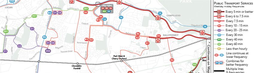
Document No.:             20.133-RTP-01                                Page   9    of   43

The National Cycle Manual’s onerous requirements for apartment developments involve 1 space per
bed plus 0.5 spaces per unit, equating to 937 No. cycle parking spaces. The proposed development
thus provides 83% of this very onerous requirement.

2.4 CAR PARKING REQUIREMENTS FOR THE RESIDENTIAL DEVELOPMENT BASED ON THE NEW
    APPARTMENT GUIDELINES

Sustainable Urban Housing: Design Standards for New Apartments (Guidelines for Planning
Authorities) was published by the Department of Housing, Planning and Local Government in March
2018. Chapter 4 of this report refers specifically to revised car parking requirements for new
apartment developments.

Its recommendations can be summarized as follows:
The quantum of car parking is dependent primarily on the location of the subject site. Three categories
of location are defined:

Central and/or Accessible Urban Locations:
Apartments in central locations that are well served by public transport, in which situation car parking
provision to be wholly eliminated or substantially reduced. These locations are most likely to be in
cities, within 15 minutes walking distance of city centres or centrally located employment locations.
These locations include sites within 10 minutes walking distance of DART, commuter rail or LUAS stops
or within 5 minutes walking distance of high frequency (min 10-minute peak hour frequency) bus
services.

Intermediate Urban Locations
This applies to apartments in suburban/urban locations served by public transport or close to town
centres or employment areas and particularly for housing schemes with more than 45 dwellings per
hectare. For this category, planning authorities may consider a reduced overall car parking standard.

Peripheral and/or Less Accessible Urban Locations
Apartments in relatively peripheral or less accessible urban locations will require one car parking space
per unit, together with an element of visitor parking, such as one space for every 3-4 apartments.

It is reasonable to assume that the subject site comes within the first category – a central area, within
less than 10 minutes’ walk from the LUAS Red Line.

On the basis of this classification, it was concluded that a provision of between zero and 0.5 parking
spaces in total would be appropriate for the proposed development.

The section immediately below uses mobility information from the 2016 Census to indicate the
sustainability of this level of car parking provision at the proposed development.

2.5 PROJECTED CAR USAGE IN GENERAL PROXIMITY TO PROPOSED DEVELOPMENT

Car ownership levels and modal split data from the 2016 Census for Electoral Districts close to the
subject site can assist in providing a case for the sustainability in transportation terms of only 41% of
residents having access to a car space.

Such evidence can help demonstrate that potential overspill onto the local road network will not occur
with the proposed level of car parking provision in place.

SD06.RL/Rev0
Document No.: 20.133-RTP-01 Page 10 of 43
In order to demonstrate that the proposed quantum of car parking is sustainable and will not result in
overspill, this report will assess existing demand for car ownership and car travel within the general
environs of the subject site using 2016 Census data.
This data enables the proportion of households in the general vicinity of the subject site who do not
own a car to be established as well as the proportion of commuters presently living in the area using
the private car for their journey to work.
Data from individual electoral districts, overall figures for Dublin City and Canal Cordon Counts are
utilized to support the proposed level of car parking provision.
Data has been obtained for the following 6 No. Electoral Districts in the general vicinity of the subject
site:
Walkinstown A (ED containing part of the Carriglea development)
Crumlin A
Crumlin B
Crumlin E
Inchicore A
Inchicore B (ED containing part of the Carriglea development)
Table 2-3 below indicates the percentage of households in each of these ED’s with no car.
Figure 2-1 contains a map showing the location of the 5 No. Electoral Districts close to the subject site.
Electoral District Total No. of No. of households % households with
households with no car no car
Walkinstown A 1043 299 30
Crumlin A 1439 471 33
Crumlin B 1183 395 33
Crumlin E 1070 382 36
Inchicore A 1025 337 33
Inchicore B 815 307 38
AVERAGE 33
Table 2-3: Car ownership levels in ED’s close to proposed development
SD06.RL/Rev0Document No.: 20.133-RTP-01 Page 11 of 43 Figure 2-1: Chosen Electoral Districts relative to location of proposed development Thus, the above figures demonstrate that more than one-third of the existing inhabitants of the area close to the proposed development do not own a car. Thus only 66% are in a position to make the journey to work by this mode of travel. In order to analyze in detail, the travel behavior of commuters in the vicinity of the proposed development, let us look first at modal splits for commuters within the Dublin city area. 2.6 MODAL SPLITS FOR THE PRIVATE CAR - 2017 CANAL CORDON COUNTS DOCUMENT The results within this document detail the volume of vehicles and people crossing the Canal Cordon into Dublin city center in the morning peak between 7am and 10am. The purpose of collecting this data is to track trends in the modes of travel people are using to travel to the city center. It indicates the degree of success of various transport management measures / policies in changing commuter travel behavior. A comprehensive picture of the modes of travel of commuters was compiled for the period 2006 to 2019. Table 2-4 below details the modal splits compiled for the 10-year period from 2010 to 2019: SD06.RL/Rev0
Document No.:                     20.133-RTP-01                                           Page   12       of   43

                            Percentage for each mode
 Mode                       2010        2011 2012 2013 2014 2015 2016 2017 2018                                 2019
 Private car users          39.8        38.0   37.0      35.4      33.3       32.6   31.8       29.2   28.3     26.7
 Pedestrians                8.3         7.9    9.2       9.1       10.2       9.4    10.5       11.8   11.2     11.4
 Cyclists                   3.3         3.7    4.3       4.7       5.4        5.4    5.9        5.9    5.7      6.0
 Public transport           45.9        47.5   46.4      47.9      48.4       49.8   49.1       50.7   52.6     53.5

Table 2-4: Modal share for commuters crossing canal cordon 2010 to 2019.

It can be seen that car usage has gradually reduced over the past 10 years, with the modal split for
private car usage now below 27%, with public transport at just above 53%.

2.7 MODAL SPLIT FOR THE PRIVATE CAR – 2016 CENSUS RESULTS FOR ELECTORAL DISTRICTS IN THE
    VICINITY OF THE PROPOSED DEVELOPMENT

Table 2-5 contains the modal splits for car, bus, and LUAS / Rail travel for the 6 No. Electoral Districts
close to the subject site whose car ownership levels have been detailed within Table 2.5:

                                                                                                    VAN /
                       CAR    CAR
                                                                         LUAS/TRAIN CYCLING WALKING HOME
 Mode                  DRIVER PASSENGER BUS (%)
                                                                         (%)        (%)     (%)     / NOT
                       (%)    (%)
                                                                                                    STATED
 Walkinstown
                       42           3                  17                8                 8           9              13
 A
 Crumlin A             41           2                  13                15                8           10             11
 Crumlin B             38           3                  13                10                11          14             11
 Crumlin E             38           3                  16                9                 9           13             12
 Inchicore A           32           3                  14                16                11          11             13
 Inchicore B           31           2                  8                 17                5           11             26
 Average               37           3                  14                13                9           11             13
 Excluding Van
 / stay at
                       43           3                  16                15                10          13             -
 home / not
 stated
Table 2-5: Modal splits for electoral districts in vicinity of subject site

Appendix 2 contains details of the 2016 Census data from the six Electoral Districts.

Thus, for the existing inhabitants in 6 No. Electoral Districts close to the subject site, as detailed within
the 2016 Census, excluding vans, workers staying at home and no preference stated, 43% commute
by private car (plus 3% as passengers) with 31% commuting by bus, train, or LUAS and 20% cycling or
walking.

These figures are critical in two respects. Firstly, it demonstrates that providing car parking spaces for
47% of occupants of the proposed development is entirely sustainable, given that the 2016 census
indicated a modal split for provide car use for the journey to work for the general area of 43%.
Secondly, as indicated by the year-on-year canal cordon counts, this figure has, in all probability,
reduced in the intervening two years to 2020.

SD06.RL/Rev0
Document No.: 20.133-RTP-01 Page 13 of 43 The 2016 census figures indicates a modal split for the private car in the region of 37% before correction, higher than the 2017 canal Cordon result of 29%. Given that the canal cordon indicates a further 2.5% reduction between 2017 and 2019, it would be reasonable to assume that the Census modal split has reduced further below 37%, and would continue to further reduce by 2023, the projected day of opening. 2.8 CONCLUDING COMMENT This section of the report demonstrates that, given existing travel patterns close to the subject site, and its assumed designation within the New Apartment Guidelines as an ‘intermediate area’ within close proximity to a high frequency major bus corridor, a car parking provision of 0.47 per residential unit (185 No. spaces for 393 No. apartment units) is entirely sustainable. However, providing a limited quantum of car parking spaces places an onus on the applicant to demonstrate that the site is configured in such a manner that enables all residents at the proposed development to commute to work modes of travel other than the private car. The remaining sections of this document seek to demonstrate that such is the case for the proposed development at Carriglea. SD06.RL/Rev0
Document No.:             20.133-RTP-01                               Page   14    of    43

3. GUIDANCE AND POLICY DOCUMENTS ON RESIDENTIAL TRAVEL PLANS

3.1 INTRODUCTION

The relevant documents at an international, national, and local level are detailed within this section.

3.2 NATIONAL / INTERNATIONAL / LOCAL POLICY ON SUSTAINABLE TRAVEL / TRAVEL PLANS

             SMARTER TRAVEL, A SUSTAINABLE TRANSPORT FUTURE (STASTF) – A NEW TRANSPORT
        POLICY FOR IRELAND, 2009 – 2020

This document plans for an integrated transport network that enables the efficient, effective, and
sustainable movement of people and goods, to contribute to economic, social, and cultural progress.

It recognizes that, without intervention, congestion will get worse, transport emissions will continue
to grow, economic competitiveness will suffer, and quality of life will decline. The key goals are to
Improve quality of life and accessibility to transport for all and for people with reduced mobility and
those who may experience isolation due to lack of transport; to Improve economic competitiveness
through maximizing the efficiency of the transport system and alleviating congestion and
infrastructural bottlenecks; to minimize the negative impacts of transport on the local and global
environment through reducing localized air pollutants and greenhouse gas emissions; to reduce
overall travel demand and commuting distances travelled by the private car and to Improve security
of energy supply by reducing dependency on imported fossil fuels.

Its implementation will help meet Ireland's international obligations towards tackling climate change,
enhancing existing legislative provisions to deliver deeper integration of travel and spatial planning
and to support the full integration and alignment of transport plans with the development plan
process and local area planning, and ensure better integration of land use planning and transport
policies in the relevant planning guidelines as part of their ongoing review and we will avail of policy
directives to give effect to specific measures needed to meet the vision for sustainable travel.

It details a requirement that developments above a certain scale have viable travel plans in place, that
significant housing development in all cities and towns must have good public transport connections
and safe routes for walking and cycling to access such connections and local amenities, and the
necessity for the integration of cycling and public transport with the proposal.

               GREATER DUBLIN AREA TRANSPORT STRATEGY, 2016-2023

The Greater Dublin Area (GDA) Transport Strategy has, as its central objective, the promotion of
efficient, effective, and sustainable movement of people and goods, thereby helping to reduce modal
share of car-based commuting to a maximum of 45%. To achieve these principles, future
developments must have transport as a key consideration in land use planning – integration of land
use and transport to reduce the need to travel, reduce the distance travelled, reduce the time taken
to travel, promote walking and cycling especially within development plans, protect the capacity of
the strategic road network, ensure a significant reduction in share of trips taken by car, especially
those trips which are shorter or commuter trips, and provide alternate transport modes in order to
reduce the strain on the M50 as current increase in traffic is unsustainable.

The mobility management plan demonstrates the proximity of site to improved public transport
provisions (such as the proposed Bus Connects Core Bus Corridor), which will improve overall levels
of public transport provision within the GDA, improving public transport options for residents.

SD06.RL/Rev0
Document No.: 20.133-RTP-01 Page 15 of 43
DUBLIN CITY COUNCIL DEVELOPMENT PLAN, 2016-2022
The Dublin City Development Plan (DCDP) provides an integrated framework for the development of
the city in an inclusive and sustainable manner which is resilient on social, economic, and
environmental fronts in the short and longer term. The plan emphasizes the need for Dublin to
become a low-carbon city and the role of compact, self-sustaining communities and neighborhoods,
urban form and movement has to play in achieving this goal.
The DCDP details a Core Strategy which includes housing, settlement, employment, retail, and public
transport strategies. The strategy translates into a number of broad strands which form the basis for
the policies and objectives outlined in the plan, including the creation of sustainable neighborhoods
and communities and the development of policies and objectives to achieve this.
Relevant policies include:
The promotion modal shift from private car use towards increased use of more sustainable
forms of transport such as cycling, walking and public transport;
The improvement of the city’s environment for walking and cycling through the
implementation of improvements to thoroughfares and junctions and also through the
development of new and safe route;
The improvement of the pedestrian environment;
The promotion of the development of a network of pedestrian routes which link residential
areas with recreational, educational and employment destinations to create a pedestrian
environment that is safe and accessible to all;
The promotion of best practice mobility management and travel planning to balance car use
to capacity and provide necessary mobility via sustainable transport modes;
The provision of sustainable levels of car parking and storage in residential schemes in
accordance with development plan car parking standards so as to promote city center living
and reduce the requirement for car parking; and
The encouragement of new ways of addressing the paring needs of residents (such as car
clubs) to reduce the requirement for car parking.
MAKING RESIDENTIAL TRAVEL PLANS WORK: GUIDELINES FOR NEW DEVELOPMENT -
UK DEPARTMENT OF TRANSPORT, 2005
This document details the policy context of an RTP, exploring the benefits they can offer and sets the
context in terms of related policy issues, outlines travel plan design and content, including objectives
and guiding principles, and the measures that can be secured as part of a residential travel plan. It
details the process of requiring a residential travel plan, covering the key stages in the residential
travel planning process, the management, monitoring and enforcement of the RTP, highlighting key
issues to be taken into account to ensure that the travel plan is effective and continues to be effective.
It also details a strategic framework which reviews the planning and transport framework
underpinning an effective residential travel plan.
The guidance within this document is used extensively within the RTP for Carriglea. It stated that travel
planning had, to date, largely focused on the development of destination travel plans, which are
generally designed to reduce car use to a specific destination - such as a workplace, school, or a visitor
attraction. Within such a plan, the office employer, the school, or the attraction itself, in partnership
with others such as the planning authority and public transport operators, destination travel plans
focus mainly on a particular journey purpose, e.g., the journey to work, school, etc.
SD06.RL/Rev0Document No.: 20.133-RTP-01 Page 16 of 43
The document states that, in contrast, a residential travel plan is concerned with journeys made from
a single origin multiple and changing destinations. This crucial difference raises a number of issues and
explains the need for specific good practice advice, though many aspects of good practice in
developing destination travel plans are likely to apply to residential travel plans.
It states that key differences between the origin-based residential travel plans and destination office
/ school travel plans are:
The pattern of journeys originating at home is more varied, with residents having multiple
destinations and different needs and travel choices over time. This is a crucial difference
compared with destination-based plans which normally only deal with a single journey
purpose e.g., access to work.;
An ongoing management organization and structure for the travel plan needs to be put in
place, as there is often no single company or institution to provide continuity and a common
point of interest for residents.
This guidance document looks at residential travel plans in the context of new development, where
the travel plan will normally be drawn up before the residents are in occupation. It is envisaged that
the measures included in a residential travel plan will include demand management and smart travel
tools, as well as improvements in services and facilities. As with destination travel plans, it would
generally combine the 'soft' measures of promotion and awareness raising with 'hard' measures and
improvements to design, infrastructure and services, both on-site and off-site. In addition, because of
the many purposes of journeys from home, the residential travel plan may need to incorporate a wider
range of measures to encourage more sustainable travel choices. It will need to be "fit for purpose"
given the substantial variety of scale, location, and type of residential development.
A residential travel plan should also include targets, monitoring and management arrangements to
ensure that the objectives of the travel plan are achieved and that it remains sustainable over the
longer term. It should be secured through the planning system as part of the assessment of the
planning application. As with other travel plans, residential travel plans should be a key requirement
on a par with highways improvements or instead of them. For any residential development likely to
generate significant levels of traffic. They should not, of course, be a reason for approving an
unacceptable development in the wrong location but, where practical, providing a means of solving
accessibility issues.
Travel planning for residential development is stated to have the potential to help achieve more
sustainable communities by improving their accessibility. New housing development is normally
characterized by high car trip generation. However, better choices about the location and density of
new housing, combined with the increased use of residential travel plans, should deliver a real impact
on travel patterns and aid progress towards sustainable transport and land use objectives.
If the travel plan is designed into the residential development from the beginning and supported by a
long-term commitment and mechanisms for implementation, potential local benefits.
Reducing the need for car use with benefits in terms of reduced traffic, congestion, air
pollution and accidents.
Improving accessibility and travel choice for reaching local facilities.
Improving public transport provision for people in nearby developments because of the
increased economies of scale.
Increasing scope for child-friendly housing layouts with fewer roads, vehicle movements and
parking areas; Complementing nearby travel plans, and possibly even assisting them in
achieving more ambitious initiatives.
SD06.RL/Rev0Document No.: 20.133-RTP-01 Page 17 of 43
Improving access by the wider community to the residential development by sustainable
modes of transport.
Representing good practice and providing an educational tool to help change perceptions
about the convenience and benefits of not using the car where alternatives exist.
Achieving more attractive environments that contribute to regeneration and renewal
initiatives.
Increasing marketability of the development as more households seek to change their travel
behavior.
The document thus clearly illustrates the benefits of a well thought out Residential Travel Plan to
achieving more environmentally sustainable communities.
SD06.RL/Rev0Document No.: 20.133-RTP-01 Page 18 of 43
4. THE TRAVEL PLAN PYRAMID
The UK document ‘Making Residential Travel Plans Work’ details the travel plan pyramid that helps
demonstrate how successful plans are built on the firm foundations of a good location and site design.
A Plan should also combine hard measures – such as new bus stops and cycle ways, and soft measures
– such as discounts on season tickets and help with individual journey planning. All measures should
be integrated into the design, marketing, and occupation of the site. In addition, parking restraint is
often crucial to the success of the plan in reducing car use.
An image of the pyramid is contained within Appendix 3.
The travel pyramid, as detailed within ‘Making Residential Travel Plans Work’, contains the following
five key concepts that are central to a good RTP:
Location - Residents need to be within easy reach of shops and services – so that walking or
cycling becomes the natural choice.
Built Environment – Low-density developments are hard work to get round by bike and foot.
Encouraging compact development that is walking and cycling friendly, with low parking
allowances, is crucial in encouraging sustainable travel choices.
Travel Plan Coordinator - Successful travel plans need people. The Coordinator plays a crucial
role in developing the plan and working with residents and management to ensure the plan
meets their needs for access and evolves over time.
Services and facilities - Good public transport and a car club can help reduce the need for on-
site parking. Other measures, such as broadband internet access and home deliveries can
reduce the need to travel off site.
Promotional strategy - Welcome packs, public transport discounts and cycling incentives can
all help introduce the travel plan to residents and build enthusiasm.
In terms of location and built environment, one can see the significant advantages of the subject site,
within easy access of bus facilities, with the layout of the proposed development making cycling and
walking safer and more efficient.
This report will demonstrate the central role that will be undertaken by the Travel Plan Coordinator in
setting targets, updating the Travel Plan, monitoring use of car club spaces, and maximizing the
circulation of promotional material among residents.
SD06.RL/Rev0Document No.: 20.133-RTP-01 Page 19 of 43 5. THE CONTENTS OF RESIDENTIAL TRAVEL PLAN Section 6 of this report will summarize the existing public transport and cycling facilities at the subject site. Section 7 takes the existing commuter travel patterns for the area and proposes year-of-opening modal splits for the proposed development. It also contains proposed future improvements public transport, cycling and walking facilities nearby which will assist in the attainment of the stated targets. Section 8 details the objectives of the Travel Plan Strategy and lists a suite of measures which is planned to be implemented to facilitate the achievement of these objectives. Section 9 details the central role of the Travel Plan Coordinator in the attainment of the objectives as set out within Section 8. Section 10 contains some concluding comments on the residential travel plan. SD06.RL/Rev0
Document No.:                  20.133-RTP-01                           Page   20    of   43

6. ROAD NETWORK, AND EXISTING PUBLIC TRANSPORT AND CYCLING FACILITIES

6.1 SITE LOCATION

The general location of the subject site in relation to the surrounding road network is illustrated in
Figure 1.1 previously.

6.2 EXISTING PUBLIC TRANSPORT INFRASTRUCTURE

Bus Services
The Naas Road area is currently connected by public transport services such as Dublin Bus and the
Luas Red Line. These services are predominantly radial in nature however, providing good links
between the city center and the west but not to other areas of the city.

The Dublin Bus services in the area provide direct linkage to the city, both Route 13 and 151. The
frequency of each bus can be seen in Table 6-1, with an approximate 12-minute waiting time between
buses.

 Route                          Origin           Destination            Frequency (07:00 – 08:00)
 Route 13                       Grange Castle    Harristown             5 per hour
 Route 151                      Foxborough Rd.   Docklands              5 per hour

Table 6-1– Dublin Bus Route Frequencies

Figure 6-1 details the routes taken by the 13 and 151 in close proximity to the site of the proposed
development.

Figure 6-1: Existing bus services

SD06.RL/Rev0
Document No.:                   20.133-RTP-01                       Page   21    of   43

Luas Service
The site is located between the Bluebell and Kylemore stops on the Red line, which gives significant
access to both north and south city suburbs, as detailed within Figure 6-2:

Figure 6-2: LUAS Network

Rail Transport Services
The rail connection to the site area is located 2.5 km to the north east at the Cherry Orchard & Park
West stop on the Kildare commuter service which can be seen in Figure 6-3.

                      Rail station

Figure 6-3: Location of Park West Station relative to subject site

SD06.RL/Rev0
Document No.: 20.133-RTP-01 Page 22 of 43 There is currently a dedicated shuttle service from the Kylemore Luas stop to Park West station. The “861 Express Bus” provides a limited number of trips from the Luas stop in the morning and a limited amount in the evening. 6.3 EXISTING CYCLING PROVISION Figure 6-4 details the existing cycle facilities close to the site: Figure 6-4: cycling facilities in proximity to Carriglea site One can see that there are limited cycle lanes in the vicinity of the development, with the main link being along the Long Mile Road within the bus lane. SD06.RL/Rev0
Document No.:                 20.133-RTP-01                            Page   23    of    43

7. PREDICTED POST-DEVELOPMENT TRAVEL PATTERNS

7.1 INTRODUCTION

Based on the modal split information within section 2 of this report for the Electoral Districts in the
general vicinity of the subject site, excluding not-stated modal preferences and stay-at-home workers,
Table 7-1 below indicates a target profile for the future residents at the Carriglea SHD on the projected
day of opening:

 Transport Mode          Commuter Usage (%) (day-of-
                         opening)
 Car driver                           43
 Car passenger                         3
 Public transport                     31
 Cycle                                10
 Walk                                 13
Table 7-1 - Future Target Modal Splits for Carriglea SHD

The section below details the improvements planned to the bus and cycle network which will help
ensure that the proposed day-of-opening modal splits for the development are maintained into the
future.

7.2 FUTURE PLANNED PUBLIC TRANSPORT AND CYCLING NETWORK IMPROVEMENTS

                 BUS CONNECTS

Figure 7-1 details the Bus Connects proposals, indicating that the D3 route on the high frequency D
spine replacing the 13.

The high frequency S4 orbital route, also running close to the site, will create a direct service from
Liffey Valley and Ballyfermot across the southern side of Dublin, including Crumlin, Terenure,
Milltown, and finally UCD.

SD06.RL/Rev0
Document No.: 20.133-RTP-01 Page 24 of 43
Figure 7-1: Bus Connects proposals
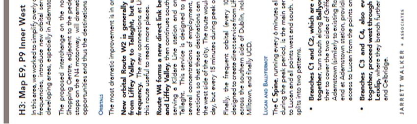
Appendix 4 provides more details of Bus Connects for the Inner West City area.
GDA CYCLE PLAN
Figure 7-2 details the network improvements proposed within the GDA cycle plan.
SD06.RL/Rev0Document No.: 20.133-RTP-01 Page 25 of 43 Figure 7-2: Cycle lane improvements detailed within the GDA Cycle Plan Providing easy access to this main cycle route into the city will allow residents of the development to use the route and cycle along the canal where they will not have to share their space with other road users such as cars, buses, or trucks. Residents of the proposed development can choose to gain access to this main cycle route via the “7D” route or alternatively along the River Carmac Greenway. Appendix 5 contains the text from the GDA Cycle Network Plan for the Dublin West Sector. SD06.RL/Rev0
Document No.: 20.133-RTP-01 Page 26 of 43
8. OBJECTIVES OF TRAVEL PLAN STRATEGY
8.1 INTRODUCTION
A Travel Plan Framework is a tool that brings together site management issues relating to transport in
a coordinated manner. This document puts in place the objectives of the mobility management
strategy for the subject site and the specific measures designed to achieve these objectives.
As the proposal includes no on-site car parking, this strategy aims to provide sustainable transport
choices for residents and visitors at the site, thus continuing to eliminate private car use for the trip
to and from the workplace. Specific measures for achieving effective modal shift away from the private
car will be detailed.
The aim of this strategy is thus to introduce measures which will maximize the chances that the modal
split targets for year of opening are met and maintained thereafter.
The objectives of the Travel Plan Strategy for the proposed development in order to meet the stated
targets for the subject site are as follows:
To manage the availability of the private car for residents (non-work purposes) (Objective No.
1);
To encourage residents to use public transport by providing information on the services
available as well financial incentives to use public transport. New public transport schemes
coming on stream will further aid the achievement of this objective (Objective No. 2);
To encourage residents to cycle to work, if appropriate, by providing safe parking and general
information on the health benefits of cycling (Objective No. 3);
To encourage to walk to work if appropriate, by providing all necessary information on this
mode of travel (Objective No. 4).
A number of the proposals listed to achieve and maintain the modal splits detailed within Table 7-1
above are easy and inexpensive to implement. Other measures require initial co-operation and co-
ordination both within and between organizations.
The general morale of residents will be, to an extent, dependent on their general state of health and
fitness, particularly where, for some, long periods are spent behind a desk working with computers
when they get to their workplace. The profile of their journey to work can be a significantly beneficial
factor in regard to increased fitness and wellbeing.
8.2 OBJECTIVE NO. 1 - MANAGE PRIVATE CAR AVAILABILITY FOR RESIDENTS (WORK AND NON-
WORK PURPOSES)
The promotion of car sharing among residents using the development website can help decrease the
car driver modal share and increase the car passenger percentage for work-related purposes.
Rather than all residents requiring access to a parking space in order to have a car available to make
non-work-related trips for shopping and leisure purposes, an alternative and more sustainable
approach is proposed involving the provision of information on car clubs to residents in order to cater
for the non-trip-to-work-related car demand.
It is proposed that the Travel Plan Co-Ordinator will provide information on the availability of car club
vehicles for residents within the development, with 10 No. spaces being provided initially.
SD06.RL/Rev0Document No.: 20.133-RTP-01 Page 27 of 43
Such actions will have the effect of reducing the modal split for car drivers below the opening day
projection of 43%.
8.3 OBJECTIVE NO. 2 - ENCOURAGING GREATER USE OF PUBLIC TRANSPORT FOR THE JOURNEY TO
WORK
GENERAL
Public transport will be a favored transport option for a predicted 31% of residents at the proposed
development on its day of opening.
The Bus Connects, in the longer term, will significantly improve public transport services at the subject
site.
PUBLIC TRANSPORT INFORMATION
It is vital that timetable information is available to residents in order to encourage maximum usage of
the public transport system. Dublin Bus and LUAS timetables should be posted on the notice board
within the apartment complex and / or the web site to be set up by on-site management.
8.4 OBJECTIVE NO. 3 - ENCOURAGING MORE RESIDENTS TO CYCLE TO WORK
Cycling will be a favored transport option for a predicted 10% of residents at the proposed
development on its day of opening.
The provision of 781 No. cycle parking spaces on site will help maintain and strengthen this modal
split. The proposed GDA cycle network improvements detailed within section 7 above will help
maintain the projected modal split for cycling at the subject site.
8.5 OBJECTIVE NO. 4 - ENCOURAGING MORE RESIDENTS TO WALK TO WORK
Walking will be a favored transport option for a predicted 13% of residents at the proposed
development on its day of opening.
Maintenance of this modal share will be facilitated by noticeboard and website information on
quickest routes to town, nearby districts and closest bus stops / LUAS stop.
SD06.RL/Rev0Document No.: 20.133-RTP-01 Page 28 of 43
9. ROLE OF THE TRAVEL PLAN COORDINATOR FOR THE PROPOSED RESIDENTIAL
DEVELOPMENT
9.1 APPOINTMENT OF TRAVEL PLAN COORDINATOR
It will be the intention of on-site management at the proposed development’ that a Travel Plan
Coordinator be appointed to administer, implement, monitor and review travel plan management
issues within the residential component of the proposed development. The coordinator will also liaise
with the local authority, public transport companies and facility managers on issues relevant to the
maximization by commuters of non-car-based journeys to work.
9.2 DUTIES OF THE TRAVEL PLAN CO-ORDINATOR
The application is founded on minimal use of the private car by all residents and the maximization of
travel by soft modes and public transport.
The coordinator will have a vital role in encouraging and enabling residents at the subject site to adopt
the measures listed within the document to achieve the objectives listed above within section 8. The
duties of the coordinator are detailed below under the following headings:
Promoting the environmental and health benefits of their travel choices
Promoting bike use
Promoting walking to work
Promoting rail and bus-based travel.
Monitoring the modal splits for residents’ journey to work
PROMOTING THE ENVIRONMENTAL AND HEALTH BENEFITS OF THEIR TRAVEL CHOICES
It will be the duty of the coordinator to make residents aware of the environmental and health
consequences of their travel choices. Various media should be employed in order to communicate this
message. These could include a newsletter and a mobility website and providing information on issues
such as available public transport services, where to buy a bike, and the health benefits of cycling /
walking.
PROMOTING BIKE USE
The coordinator can promote the use of this mode of travel using other measures such as the setting-
up of a cycle user group so that experienced cyclists within the development can help encourage
newcomers to the mode of travel. The coordinator can also help by keeping tool kits and spare parts
on site for cyclists to avail of. The web site and newsletter could also be an aid to encouraging the
mode of travel by encouraging the potential time savings involved. In addition, the coordinator can
keep in contact with the local authority to monitor the progress in implementation of the proposed
cycle track network in the locality.
It would also be possible for management at the proposed residential development to agree a group
bicycle insurance scheme for residents at preferential rates in order to maximize its use as a mode of
travel to work.
SD06.RL/Rev0Document No.: 20.133-RTP-01 Page 29 of 43
In addition, management might subsidize the cycling mode by purchasing an initial stock of bicycles
to loan to residents at preferential rates. Such a scheme would not be expensive and would have the
added benefit of raising awareness of it as a mode of travel and generally encouraging cycle use.
PROMOTING WALKING TO WORK
As with cycling, the coordinator should promote the health and fitness benefits of walking and its
general viability as a method of getting to work. The coordinator can also liaise with the local authority
on work being done near the candidate site to make the local road network more pedestrian friendly.
PROMOTING RAIL AND BUS BASED TRAVEL
The coordinator will promote a public transport culture among residents. The coordinator can use the
newsletter and website to provide information on public transport, in particular timetable
information, fares, bus and / DART stop location and route planning, together with information on
annual and monthly public transport tickets, carrying potential tax benefits for commuters.
MONITORING THE MODAL SPLITS FOR THE RESIDENTS’ JOURNEY TO WORK
To maximize the effectiveness of the Travel Plan, the coordinator should be responsible for the
ongoing monitoring of the modal splits within the plan, including the carrying out on a regular basis
of travel surveys of all on-site residents.
SD06.RL/Rev0Document No.: 20.133-RTP-01 Page 30 of 43 10. CONCLUDING COMMENT This Travel Plan is required to ensure the sustainability of the limited provision of car parking at the subject site, consistent with the New Apartment Guidelines but below the maximum provision as detailed by the planning authority. This report has demonstrated that the proposed reduced car parking provision for the residential development is entirely sustainable based on current car ownership and modal splits for the journey to work for existing residents living within Electoral Districts close to the subject site and is entirely in line with recommendations on parking provision set out in the ‘Sustainable Urban Housing: Design Standards for New Apartments (Guidelines for Planning Authorities): March 2018.’ A parking provision of 0.47 spaces per apartment unit is sustainable, given that car usage for the journey to work is in the region of 43% and public transport / soft mode usage for the journey to work in the region of 57%. The Residential Travel Plan within this report aims to achieve a sustainable travel culture for residents at the residential development by outlining a travel strategy, by listing measures to achieve its objectives and by committing to appoint a travel plan coordinator to oversee and monitor progress towards the target modal splits predicted for the site on its day of opening. SD06.RL/Rev0
Document No.:   20.133-RTP-01   Page31 of 43
                                    APPENDIX

                                    1
                                    SITE LAYOUT
                                    PLAN

SD06.RL/Rev0
Document No.: 20.133-RTP-01 Page 32 of 43 SD06.RL/Rev0
Document No.:   20.133-RTP-01     APPENDIX
                                     Page
                                        33 of 43

                                       2
                                       2016 CENSUS
                                       INFORMATION

APPENDIX

2
PLANS

    SD06.RL/Rev0
Document No.: 20.133-RTP-01 Page 34 of 43 WALKINSTOWN A INCHICORE A SD06.RL/Rev0
Document No.:   20.133-RTP-01   Page   35   of   43

INCHICORE B

CRUMLIN A

SD06.RL/Rev0
Document No.:   20.133-RTP-01   Page   36   of   43

CRUMLIN B

CRUMLIN E

SD06.RL/Rev0
Document No.:   20.133-RTP-01   Page   37   of   43
                                   APPENDIX

                                   3
                                   TRAVEL PLAN
                                   PYRAMID

SD06.RL/Rev0
Document No.: 20.133-RTP-01 Page 38 of 43 SD06.RL/Rev0
Document No.:   20.133-RTP-01   Page39 of 43
                                    APPENDIX

                                    4
                                    BUS CONNECTS
                                    – INNER WEST
                                    CITY AREA

SD06.RL/Rev0
Document No.: 20.133-RTP-01 Page 40 of 43 SD06.RL/Rev0
Document No.: 20.133-RTP-01 Page 41 of 43
APPENDIX
5
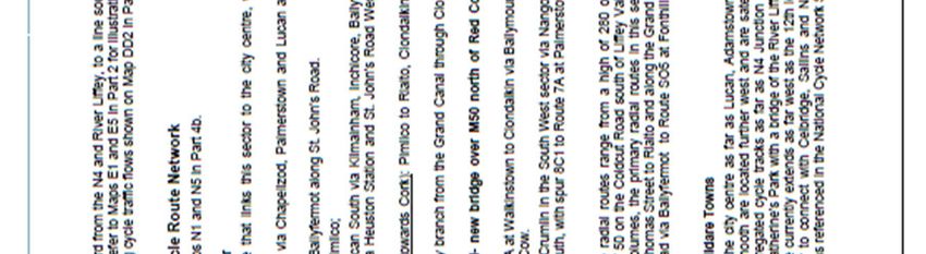
GDA CYCLE
PLAN – DUBLIN
WEST SECTOR
SD06.RL/Rev0Document No.: 20.133-RTP-01 Page 42 of 43 SD06.RL/Rev0
Document No.:   20.133-RTP-01   Page   43   of   43

SD06.RL/Rev0
You can also read