Rio Grande del Norte New Mexico - Taos Field Office Science Plan 2019 - National Monument - Bureau of Land ...
←
→
Page content transcription
If your browser does not render page correctly, please read the page content below
Rio Grande del Norte
    ‘ Monument
National

New Mexico – Taos Field Office
Science Plan 2019

U.S. Department of the Interior
Bureau of Land Management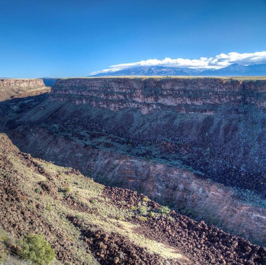
TABLE OF CONTENTS

SECTION 1: INTRODUCTION AND SCIENTIFIC MISSION                                       3
 1.1 Purpose of National Conservation Lands Science Plans                            3
 1.2. Unit and geographic area description                                           4
 1.3. Scientific Mission                                                             7
SECTION 2: SCIENTIFIC BACKGROUND OF THE NATIONAL CONSERVATION
LANDS UNIT                                                                           8
 2.1. Monument Objects and Scientific Understanding                                  8
   Cultural Resources                                                                8
     Río Grande Gorge Cultural Resources Project                                     10
     Nomadic Indian Presence in the Upper Rio Grande                                 10
   Ecological Diversity                                                              11
     Soil Maps and Ecological Site Descriptions                                      11
     Range Program and NRCS                                                          11
     Assessment, Inventory and Monitoring (AIM) Terrestrial Program                  11
     Riparian and Aquatic Habitat Assessment and Monitoring                          12
     ●    AIM National Aquatic Monitoring Framework                                  12
     ●    Proper Functioning Condition (PFC)                                         12
     Vegetation Treatment Monitoring as a part of the AIM Program (report last
     updated 2018; additional updates forthcoming).                                  12
     Rare Plant Monitoring                                                           13
     Weeds Mapping                                                                   13
     Tree-ring fire history of the Rio Grande del Norte Monument                     13
   Geology                                                                           14
     Geologic Quadrangle Mapping of Southern Taos County                             14
     Geologic Investigations of the Southern San Luis Basin                          14
     Geophysical Investigations of the San Luis Basin                                15
   Wildlife and Fisheries Resources                                                  15
     Bee Surveys                                                                     15
     Anasazi' Yuma Skipper (Ochlodes yuma anasazi) and Monarch Butterfly (Danaus
     plexippus) Studies at Wild Rivers                                        17
     Big Game Migration/Movement Corridors/Winter Range                              17
     Surveys for Nesting Pinyon Jays at Rio Grande del Norte National Monument 18

         Rio Grande del Norte National Monument Science Plan                     1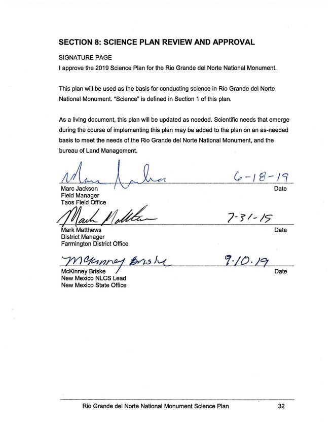
Bird Surveys at Rio Grande del Norte National Monument                     19
     Mule Deer Studies                                                          19
     Orilla Verde Riparian Recovery Study                                       20
     Aquatic macroinvertebrate assemblages of the RGDN National Monument:
     Environmental and Anthropogenic Effects                                    21
     Fisheries and Aquatic Resources                                            21
 3.1. Scientific Needs                                                          22
 3.2. Specific ongoing and future science needs                                 23
 3.3. Ranking of science needs                                                  24
SECTION 4: MEETING SCIENCE NEEDS                                                24
 4.1. Internal Organization                                                     24
 4.2. Collaboration and Partnerships                                            25
SECTION 5: SCIENCE PROTOCOLS                                                    26
 5.1. General Science Guidelines                                                26
 5.2. Authorization and tracking process                                        27
SECTION 6: ORGANIZATION AND COMMUNICATION OF COMPLETED SCIENCE 29
 6.1 Scientific Background Needed for Updates                                   29
 6.2. Internal Communications                                                   29
 6.3. Communication to the Broader BLM Organization                             30
 6.4. Communication of Scientific Results to the Public                         30
SECTION 7: INTEGRATING SCIENCE INTO MANAGEMENT                                  30
 7.1. Communications                                                            30
 7.2. Integration                                                               30
SECTION 8: SCIENCE PLAN REVIEW AND APPROVAL                                     32
SECTION 9: BIBLIOGRAPHY                                                         33
SECTION 10: UNIT’S LEGISLATION                                                  34
SECTION 11: SCIENCE COORDINATORS CONTACT INFORMATION                            39
SECTION 12: LIST OF CONTRIBUTORS                                                40
SECTION 13: TABLES 1 & 2                                                        42

        Rio Grande del Norte National Monument Science Plan                 2
SECTION 1: INTRODUCTION AND SCIENTIFIC MISSION
1.1 Purpose of National Conservation Lands Science Plans
● The National Conservation Lands was administratively established in 2000 and
legislatively codified in the Omnibus Public Land Management Act of 2009 (PL
111-11). This system encompasses nearly 900 units spread across
approximately 27 million acres of public lands managed by the Bureau of Land
Management (BLM). The BLM is mandated to conserve, protect and restore the
outstanding cultural, ecological, and scientific values of NLCS units.
● Scientific investigation can aid in the conservation, protection, and restoration of
these lands, and therefore, science is strategically planned and organized within
National Conservation Lands units. Within National Conservation Lands units
there is an expectation for ‘identifying science needed to address management
issues, communicating those needs to science providers, and incorporating the
results into the decision making process’ (BLM 2007).
● The objectives of National Conservation Lands units’ science plans are to:
○ Identify the scientific mission of the unit;
○ Summarize past scientific efforts in the unit, i.e. the scientific background
of the unit;
○ Identify the priority needs and management issues within the unit that can
be addressed by scientific inquiry;
○ Define a strategy for accomplishing the scientific goals of the unit;
○ Develop science protocols to, for example, ensure that scientific inquiry
does not negatively impact the long term sustainability of the unit and its
resources;
○ Create a system to organize scientific reports; and,
○ Help and promote the integration of science into management.
● The science plans of National Conservation Lands units are considered ‘living’
documents and should be revised and updated frequently (e.g. 3-5 years).
Scientific needs that emerge during the course of implementing a science plan
Rio Grande del Norte National Monument Science Plan 3may be added to the plan on an as-needed basis to meet the unit’s scientific
mission.
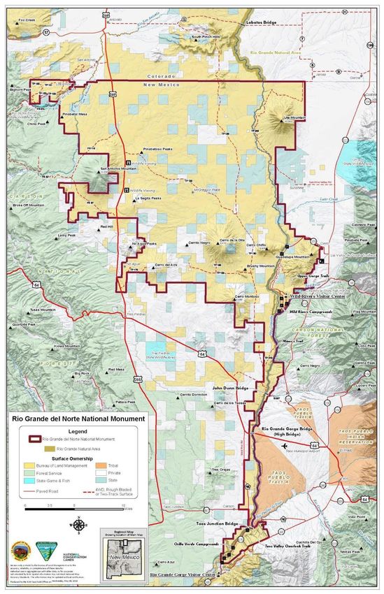
1.2. Unit and geographic area description
● Located in northern New Mexico, and including the Taos Plateau and the Rio
Grande, the Rio Grande del Norte National Monument (RGDN) was designated
by Presidential Proclamation owing to the area’s stunning geology and
“extraordinary array of scientific and historic resources.”
● Significant ecological diversity occurs within the boundary of the RGDN. Vast
sagebrush plains dominate the lower elevations of the southern portion of the
Monument. Winterfat, a subshrub which is very palatable to big game species,
dominates much of the northern portion of the Monument. A series of volcanic
cones rise from the plateau and are occupied by woodland communities, with
piñon-juniper woodlands occurring on the lower slopes and scattered ponderosa,
spruce, Douglas fir and aspen occupying higher elevations. Well-developed
riparian vegetation, including willows and cottonwoods, occurs along the Rio
Grande.
● These reserved federal lands and interests in lands encompass approximately
242,555 acres, which is the smallest area compatible with the proper care and
management of the objects to be protected; as described in Proclamation 8946
found in Section 10.
Rio Grande del Norte National Monument Science Plan 4Figure 1. Map of Rio Grande del Norte National Monument.
Rio Grande del Norte National Monument Science Plan 5● The RGDN was created on March 25, 2013 by Presidential Proclamation (#8946)
to preserve its cultural, prehistoric, and historic legacy and maintain its diverse
array of natural and scientific resources, ensuring that the historic and scientific
values of this area remain for the benefit of all Americans (see Section 10). This
includes the protection of “cultural resources, geologic resources, wildlife, and
ecological diversity” (BLM 2013).
● The Resource Management Plan (RMP) for RGDN is currently in draft by the
BLM Taos Field Office. It is anticipated that the draft alternative matrix will be
finalized and shared with the public for review within the 2019 calendar year. The
RMP for RGDN will seek to articulate the intent of the Proclamation and the
objects identified therein. The objects identified by the RMP are cultural,
geologic, wildlife, and ecological diversity (BLM, 2014, pg. 5):
○ CULTURAL RESOURCES
■ The vestiges of human use demonstrated by archeological sites
and artifacts are found in abundance in the Monument. It is a unique
cultural landscape that has remained minimally changed over time.
○ GEOLOGIC RESOURCES
■ Geologic resources include The Taos Plateau Volcanic Field
(upon which the Monument is almost entirely located), the Rio
Grande Gorge (which cut through the plateau), and the springs in
the gorge (which provide the majority of the river flow during low
flow periods).
○ WILDLIFE
■ The Monument provides habitat for a wide variety of fish and
wildlife species both seasonally and year-round
○ ECOLOGICAL DIVERSITY
■ Ecological Diversity can be understood to include the health,
resilience, and diversity of organisms and ecosystems. Within the
Monument a diversity of habitat types exists, including cottonwood
and willows along the Río Grande riparian corridor, expansive
Rio Grande del Norte National Monument Science Plan 6sagebrush plains above the gorge and the dominant piñon-juniper
woodlands throughout Taos Plateau; and interspersed ponderosa,
Douglas fir, aspen, and spruce, predominantly in higher
elevations.
1.3. Scientific Mission
Science in BLM’s National Conservation Lands units is defined broadly as ‘including
basic and applied research in natural and social science, as well as inventory and
monitoring initiatives’ (BLM 2007). In addition, within National Conservation Lands units
there is an expectation for ‘identifying science needed to address management issues,
communicating those needs to science providers, and incorporating the results into the
decision making process’ (BLM 2007).
Science has been defined within the BLM several times (e.g. BLM 2007), but is
essentially the study of natural and social phenomena using repeatable observations or
experiments. In the context of land management, scientific data are collected, analyzed,
or synthesized to increase knowledge and support decision-making.
This Science Plan will be used as the basis for conducting science in RGDN. Scientific
efforts within RGDN should support the objects and resources identified in the
designating language including: geology, ecological diversity, wildlife (while allowing for
traditional uses such as grazing permits and leases), annual traditional fuelwood
harvesting, and piñon nut collection; so long as those uses are consistent with the
purposes of the Proclamation of the Monument. RGDN is a special designation area to
be managed in accordance with NLCS guidance. Scientific studies on the RGDN can
provide information to managers and help ensure that the authorized uses do not
negatively impact RGDN’s conservation mission or the objects of value for which the
Monument was named.
● Specifically, it is the scientific mission of RGDN to:
○ Allow and encourage pertinent science that can:
Rio Grande del Norte National Monument Science Plan 7■ inform management decisions and evaluate management
methods within RGDN;
■ improve and maintain ecosystem resiliency, function, and land
health;
■ maintain diversity and viability of plant and animal populations;
and,
■ preserve and understand socio-cultural and paleontological sites.
○ Allow and encourage long term and short term investigations.
○ Allow scientific inquiry across diverse disciplines, as appropriate within
RGDN.
○ Serve as a model system for surrounding areas, so that scientific findings
can be exported to other federal and non-federal lands.
SECTION 2: SCIENTIFIC BACKGROUND OF THE NATIONAL
CONSERVATION LANDS UNIT
2.1. Monument Objects and Scientific Understanding
● Completed and ongoing research in the RGDN covers a diverse array of topics,
including cultural resources, soils, ecological diversity, geology, wildlife and
fisheries, and fire (see Table 1). Studies include site or species-specific analyses
to landscape-scale analyses. The following is a brief review of subjects, topics,
and areas of research that pertain to the RGDN. To date, there remains a lack of
scientific information specific to the RGDN. This plan seeks to summarize
existing research and in so doing help to identify where future scientific studies
are most needed.
Cultural Resources
Integrity of the Unit (see BLM-Argonne Labs 2016a; BLM-Argonne Labs 2016b;
Dicks et al. 2017)
The setting of the Unit is largely unencumbered or encroached upon by modern
human developments. Modern developments are largely restricted to the extant
Rio Grande del Norte National Monument Science Plan 8network of unimproved roads and range improvements. Cultural landscapes,
including those associated with the Prehistoric and Early Historic periods are
very well preserved, in contrast to surrounding areas within the valley where
modern alterations to viewsheds and direct physical effects have compromised
the setting and condition of cultural landscapes and individual cultural resources.
Individual cultural resources tend to be well-preserved because of the low
intensity of current uses within the area.
Threats to Cultural Resources (see BLM-Argonne Labs 2016a; BLM-Argonne
Labs 2016b; Dicks et al. 2017):
Site Specific:
a. Unauthorized removal or collection of artifacts and other archaeological
material remains.
b. Unauthorized off-road vehicle use.
c. Vandalism, such as tagging or otherwise altering petroglyphs, standing
historic structures, and ruins.
d. Alteration, in the form of modern developments or implementation of
landscape scale treatments, including the compartmentalization of the
landscape through the building of fences, roads, and other restrictive
features within the attendant setting of individual cultural resources that
detract from the extant condition of that setting relative to the resources
period of significance.
Cultural Landscape(s):
a. Modern developments in the form of view shed and auditory intrusions
that profoundly modify and detract from the natural setting and
appearance of the National Monument landscape where its present
condition is attendant to and compatible with the periods of significance
for specific or composite cultural landscapes.
Rio Grande del Norte National Monument Science Plan 9Río Grande Gorge Cultural Resources Project Principal Investigator: Dr. Severin Fowles, Department of Anthropology, Barnard College, Columbia University. This project is an ongoing investigation that began in 2007 and is permitted, but not directly funded, by the BLM. A National Science Foundation grant award funded the 2013 effort and carried into 2015. Field work is conducted annually by undergraduate and graduate students in areas that are now included within the Monument. The project is particularly focused on the identification, recording, evaluation, and analysis of archaeological remains located in the Río Grande Gorge environment. Moreover, the research is landscape-oriented regarding how the remains of different ethnic groups over time are manifested within the Gorge environment. A number of student research projects, professional papers, theses, and dissertations have been produced or are in progress as a component output of the project. The BLM benefits directly from this work in receiving data, as well as interpretative information on the cultural resources located within the Monument. Nomadic Indian Presence in the Upper Rio Grande Principal Investigator: Dr. Lindsay M. Montgomery, Stanford University. Dr. Montgomery, who began her research in the National Monument as an undergraduate under Dr. Fowles, just completed her own research and dissertation in 2015 and received her doctorate from Stanford University. Her topic was focused upon the nomadic Indian presence in the Upper Rio Grande during the Spanish Colonial Period. Much of her field work was conducted in the Rio Grande gorge and in playa lake settings within the National Monument. Dr. Fowles and Dr. Montgomery plan to continue their research and expand upon their previous work within the Monument in 2019. Rio Grande del Norte National Monument Science Plan 10
Ecological Diversity

Soil Maps and Ecological Site Descriptions
The NRCS is currently updating Soil Map Units for the RGDN. Field work for this
effort began in 2017 and is ongoing. The updated soil maps will form the basis
for development of Ecological Site Descriptions. The Ecological Site Descriptions
will incorporate both historical and current quantitative datasets, and local
stakeholder knowledge. This project is anticipated to be completed in 2021.

Range Program and NRCS
The range program has ongoing monitoring studies on grazing allotments that
date back to the 1950s. These studies consist of photo plots and vegetation
surveys that can be used in conjunction with AIM data to determine trends and
changes in ecological diversity in the Taos Field Office.

Assessment, Inventory and Monitoring (AIM) Terrestrial Program
The terrestrial AIM program has been conducting sampling on the Monument
since 2014. The AIM sampling program provides a standardized process for data
collection on the status, condition, trend, amount, location, and spatial pattern of
resources on BLM lands. The AIM protocol is based on a set of core and
supplementary methods implemented across a statistically valid sampling design.
In the Taos Field Office, methods include plot characterization, line-point
intercept, vegetation height, gap intercept, soil aggregate stability, species
richness, as well as a number of supplemental methods including belt transect,
tree density, shrub density, Describing/Interpreting Indicators of Rangeland
Health (D/IIRH), and pollinator habitat assessment. The AIM strategy is further
described in Herrick et al, 2009. AIM core methods can be used to analyze the
status and trend of the RGDN Resources, Objects, and Values (ROVs).

 Rio Grande del Norte National Monument Science Plan                             11
Riparian and Aquatic Habitat Assessment and Monitoring

   ● AIM National Aquatic Monitoring Framework
       The National Aquatic AIM strategy is designed to promote integrated
       cross-program resource inventory, assessment and monitoring at multiple
       scales of management. The Aquatic AIM strategy is used to collect
       consistent, comparable and quantitative monitoring data to understand
       conditions and trends of renewable resources. An introduction to the
       framework and indicators for lotic systems can be found in BLM Technical
       Reference 1735-1 (BLM 2015) and the field protocol is described in the
       AIM National Aquatic Monitoring Framework Field Protocol (BLM 2017).

   ● Proper Functioning Condition (PFC)
       The PFC assessment protocol or method (BLM Technical Reference
       1737-15 - 2015) refers to a consistent approach for considering
       hydrologic, vegetative, and geomorphic attributes and processes to
       assess the condition of riparian areas. A goal of BLM RMPs is to manage
       lotic systems at Proper Functioning Condition (PFC) or moving towards it
       (i.e. Functioning-at-Risk Upward Trend).

Vegetation Treatment Monitoring as a part of the AIM Program (report last
updated 2018; additional updates forthcoming).
Principal Investigator: Taos Field Office, BLM, NM
In 2014 an effort was initiated to monitor vegetation treatment projects carried out
by the Taos Field Office within the RGDN using the AIM program. AIM plots were
established within treatment areas with plots established outside of treatment
areas serving as a control. This monitoring effort is ongoing with additional plots
being established within vegetation treatment areas each year. Established plots
will be revisited allowing for long-term trends in data to emerge. Summary reports
are updated annually as new data is gathered. Results from the monitoring effort
are intended to help guide appropriate adaptive management strategies related
to vegetation treatments (i.e., thinning, Rx fire, discing, brush hogging, drill
seeding, etc.) on the Monument.

 Rio Grande del Norte National Monument Science Plan                               12
Rare Plant Monitoring Principal Investigator: Taos Field Office, BLM, NM. Demographic monitoring plots for two BLM Sensitive plant species found in the RGDN, Taos spring parsley (Cymopterus spellenbergii) and Ripley’s milkvetch (Astragalus ripleyi), were installed in 2017. Plots were primarily established on Guadalupe Mountain. Annual monitoring of these plots may provide information on overall population health and demographics. Monitoring may also investigate and record indicators where rare plant locations occur throughout the RGDN, to include precipitation and temperature regimes. Outside of the vegetation treatments, other demographic plots will inform overall population trends. The field office and partners will continue to document new individual occurrences of all special status plants. More information is needed for Rare Plant Monitoring within the RDNM. Weeds Mapping Principal Investigator: Taos Field Office, BLM, NM. In 2017, using a newly developed program in ArcGIS which is accessed on portable tablets, the locations and size of noxious weed infestations, as well as areas that have been treated for noxious weeds on the Monument, are captured in a digital format. The program was built to be compatible with National Invasive Inventory and Monitoring System (NISMS) and all data collected in the program is “pushed” to NISMS at the end of each fiscal year. The purpose of the weed mapping project is (1) track the presence and potential spread of noxious weeds on the Monument (as well as other areas within the Taos Field Office) (2) guide treatment efforts and planning (3) help to monitor the effectiveness of noxious weed treatments. Tree-ring fire history of the Rio Grande del Norte Monument Principal Investigator: E.Q. Margolis, USGS NM Landscapes Field Station. Rio Grande del Norte National Monument Science Plan 13
The goal of this study is to use tree rings to reconstruct a preliminary, multi-
century fire history at multiple sites within the RGDN. Fire regime reconstruction
includes fire frequency, seasonality, synchrony between sites (to infer fire
spread, or not), and fire-climate relationships. It was funded by the BLM NM
State Office in 2017 and the results are intended to inform fire and vegetation
management. Preliminary collections indicate historically frequent, low-severity
fire (as indicated by tree-ring fire scars) in the upper elevation ponderosa pine
forests of Cerro Montoso, Cerro de la Olla, Cerro del Aire, and the Guadalupe
Mountains.

Geology

Geologic Quadrangle Mapping of Southern Taos County
Principal Investigator: Dr. Paul Bauer, New Mexico Bureau of Geology and
Mineral Resources (NMBGMR) at New Mexico Tech.
This Project is an ongoing effort that began in 1997, and is funded by the
NMBGMR and the U.S. Geological Survey under the STATEMAP Program. The
first goal is to complete geologic maps of 7.5 minute quadrangles in the southern
half of Taos County along the Río Grande corridor. Field work for the following
quadrangles that contain Monument lands has been completed: Taos SW, Los
Cordovas, Arroyo Hondo, Guadalupe Mountain, and Questa. The second goal, in
cooperation with USGS colleagues, is to develop a seamless, ArcGIS-based
geologic map compilation of all of southern Taos County. This work will be
ongoing for at least one more year, and will ultimately provide the BLM and
others with a modern, detailed, digital geologic map of the southern half of the
Monument.

Geologic Investigations of the Southern San Luis Basin
Principal Investigator: Dr. Ren A. Thompson, USGS, Denver, CO.
This multi-year effort is part of a large interdisciplinary USGS project (Cenozoic
Landscape Evolution of the Southern Rocky Mountains – R. Thompson & S.

 Rio Grande del Norte National Monument Science Plan                           14
Minor, Project Chiefs) funded by the FEDMAP component of USGS National
Cooperative Geologic Mapping Program. This research includes geologic
mapping and regional geologic synthesis investigations of the Taos Plateau
region of the southern San Luis Basin area. Geologic mapping includes
1:24,000-scale mapping of northern Taos County. Mapping of the San Antonio
Mountain area was completed and ongoing work in on the Montoso, Petaca
Peak, Pinabetoso Peaks, La Segita Peaks NE, Cerro de la Olla, and La Segita
Peaks quadrangles was conducted. Integration of USGS and NMBGMR geologic
mapping will result in seamless 1:50,000 geologic map coverage of the
Monument (coordinated with Paul Bauer, NMBGMR).

Geophysical Investigations of the San Luis Basin
Principal Investigator: Dr. V.J.S. Grauch, USGS, Denver, CO.
This multi-year effort is part of a large interdisciplinary USGS project (Cenozoic
Landscape Evolution of the Southern Rocky Mountains - R. Thompson & S.
Minor, Project Chiefs) funded by the FEDMAP component of the USGS National
Cooperative Geologic Mapping Program. This research effort is focused on 1)
development of a regional scale gravity model for the San Luis Basin and
derivative basin depth and geometry determinations; and 2) aeromagnetic and
ground magnetic modeling studies of the Taos Plateau region for identification of
faults, stratigraphic correlations, and subsurface geologic characterizations.
Integrated geologic/geophysical studies of the Embudo fault zone at the southern
end of the monument have just been completed in collaboration with New Mexico
Bureau of Geology and Mineral Resources, with a 2017 publication in the journal
Geosphere and a NMBGMR open-file report.

Wildlife and Fisheries Resources

Bee Surveys
Principal Investigator: Olivia Messinger Carril, Institute for Applied Ecology.
New Mexico is estimated to harbor between 1,000 and 1,400 bee species, which,
astonishingly, represents about 1/4 of all bees found in the United States.

 Rio Grande del Norte National Monument Science Plan                              15
However, specific documentation remains extremely poor. For example, there
were only 28 species of bees recorded for Taos County. Limited collecting efforts
hamper the ability to assess the status of pollinator health, bee species richness,
and population dynamics in New Mexico as well as on the Monument. Funding
for a comprehensive survey of the bees on the RGDN was awarded in 2016.

Goals for the bee survey project include:
1) create a thorough inventory of this extremely understudied region, complete
with plant associations and phenological records, annotated to include what is
known from existing literature about nesting habits;
2) construct a robust protocol, and establish plot-locations, for long-term
monitoring of the Rio Grande del Norte’s bees;
3) contribute to the scant knowledge about the bees of New Mexico, through
publications in relevant scientific publications; and
4) institute a culture of pollinator appreciation among visitors, by involving them in
the collection, observation, and identification of the monument’s bee species.

Sampling began in the fall of 2016. During the 2016 field season, 45 specimens
were collected, representing only a handful of species. In 2017 collecting began
in earnest, and a total of 123 species in 27 genera were recorded in Taos and
Rio Arriba counties. Interestingly, owing to these collection efforts, the Halictidae
family, which was previously undocumented in Taos County, is now represented
by several species of Lasioglossum, Halictus, and Agapostemon. Additionally,
species of Melissodes and Exomalopsis, not previously known to Taos County,
were collected. During the 2018 season, an additional 17 species were recorded
in Rio Grande del Norte, for a current total of 140 species. This number will likely
grow as the remainder of the 2018 specimens are processed and identified. To
supplement net collections, pan traps were deployed throughout the monument
in 2017 and 2018 by the AIM Program, as well as in the standardized plots
collected monthly by bee scientists. Results of the 2017 surveys are currently
being completed and will be available January 2018.

The Rocky Mountain Youth Corps also spent a full week in August 2017 working
with the Taos Field Office botanist and the state bee specialist collecting bees on

 Rio Grande del Norte National Monument Science Plan                           16
the Monument in connection with bee survey project. Collections were made at
San Antonio Mountain as well as on the Rio Grande’s Orilla Verde area.
Students used nets and pan traps to capture bees, which they then brought back
to the Taos Field Office for pinning and labelling.

Anasazi' Yuma Skipper (Ochlodes yuma anasazi) and Monarch Butterfly
(Danaus plexippus) Studies at Wild Rivers
Principal Investigator: Steve Cary, Institute for Applied Ecology.
In 2017 the Natural Resource Institute, in collaborative planning with the Taos
Field Office, conducted its second year of field studies on 'Anasazi' Yuma
Skipper (Ochlodes yuma anasazi), a BLM Sensitive Species, and Monarch
Butterfly (Danaus plexippus), under review for listing by the USFWS, at the Wild
Rivers area of the Monument. Overarching goals were to document occurrences
of both species within the Monument at Wild Rivers and fill data gaps for New
Mexico. Mark/release/recapture studies were carried out on 'Anasazi' Yuma
Skipper to assess if females that visit the flowers/nectar sources around the Wild
Rivers camp loop are lost from the reproducing population or return to patches of
its host plant, common reed (Phragmites australis), in the Gorge to lay eggs.

Big Game Migration/Movement Corridors/Winter Range

Of the 310,729 acres of BLM, private and state lands, 218,962 acres is
designated critical winter range for big game. Along the New Mexico/Colorado
State border from the San Juan Mountain Range to the Taos Plateau, the
volcanic cones of Cerro de la Olla, Cerro del Aire, Cerro Montoso, Cerro Chiflo,
and Ute Mountain to the Sangre de Cristos, and the Rio Grande corridor from the
Colorado state line to the Lower Gorge recreation area, exist as big game
migration corridors. These corridors provide habitat connectivity from the first
heavy snowfall to spring green-up. The focus of these corridors is a landscape
scale approach that examines connected geographic areas to more fully
recognize natural resource conditions and trends, natural and human influences,
and greater opportunities for resource conservation and restoration. Although
movement corridors are largely unknown, research should focus on habitat

 Rio Grande del Norte National Monument Science Plan                          17
treatments and management actions that will keep big game movement corridors
intact. As outlined in The Department of Interior Secretarial Order 3362,
collaborate with the State of New Mexico and other partners to conserve or
restore habitat necessary to sustain local and regional big-game populations
through measures that may include one or more of the following:

   ●   restoring degraded winter range and migration corridors by removing
       encroaching trees from sagebrush ecosystems, rehabilitating areas
       damaged by fire, or treating exotic/invasive vegetation to improve the
       quality and value of these areas to big game and other wildlife;
   ●   working cooperatively with private landowners and State highway
       departments to achieve permissive fencing measures, including
       potentially modifying (via smooth wire), removing (if no longer necessary),
       or seasonally adapting (seasonal lay down) fencing if proven to impede
       movement of big game through migration corridors;
   ●   avoiding development in the most crucial winter range or migration
       corridors during sensitive seasons;
   ●   minimizing development that would fragment winter range and primary
       migration corridors;
   ●   limiting disturbance of big game on winter range; and
   ●   utilizing other proven actions necessary to conserve and/or restore the
       vital big-game winter range and migration corridors across the West.
   ●   Past and current projects focus on vegetation treatments across the
       landscape for the benefit of wildlife, forest and rangeland health, wildland
       fire resiliency, modification of fences (for safe passage of big game during
       winter migration), and habitat connectivity research to inform adaptive
       management decisions.

Surveys for Nesting Pinyon Jays at Rio Grande del Norte National
Monument

Principal Investigators: K. Johnson, N. Petersen, J. Smith, & G. Sadoti, University
of New Mexico, Natural Heritage New Mexico.
In 2017, the Natural Heritage New Mexico surveyed for breeding Pinyon Jays, a
BLM NM Sensitive Species, at the Rio Grande del Norte National Monument. In
2017 and 2018, surveys were conducted on North Guadalupe Mountain, Cerro

 Rio Grande del Norte National Monument Science Plan                         18
Chiflo, Cerro Montoso, Cerro de la Olla, North Guadalupe Mountain, South Guadalupe Mountain, and Ute Mountain. In 2018, 68 nests were documented at all sites: 22 new, 34 old, and 12 platforms that were called ‘nest starts’ or ‘courtship nests’. These nests represent six definite colonies on five different mountains; five colonies were newly detected in 2018. Bird Surveys at Rio Grande del Norte National Monument Principal Investigators: N. Petersen, K. Johnson, G. Sadoti, and J. Smith. University of New Mexico, Natural Heritage New Mexico. In 2018, Natural Heritage New Mexico conducted bird point count surveys at the Rio Grande del Norte National Monument along transects in mixed conifer, piñon-juniper, riparian, sagebrush shrubland, and grassland habitats. Highest bird species richness was detected on the Pilar riparian transect, followed by the Guadalupe Mountain piñon-juniper transect, the Ute Mountain piñon-juniper transect, the Ute Mountain mixed conifer transect, the Ute Mountain sagebrush transect, and the Ute Mountain grassland transect. Species’ densities were modeled using distance sampling. Pinyon Jay, Mountain Chickadee, Hermit Thrush, and American Robin dropped off the most-common list in at least one habitat in 2018, but several species appear to be maintaining their common status: Horned Lark in Ute grassland, Black-throated Gray Warbler in piñon- juniper and mixed conifer, Yellow-breasted Chat in riparian, Spotted Towhee in Ute piñon-juniper and sagebrush, Chipping Sparrow in Ute mixed conifer, Vesper Sparrow in Ute grassland, and Sagebrush Sparrow in Ute sagebrush. To allow assessment of changes in bird species richness, abundance, and populations, it was recommended that these monitoring surveys continue, preferably on an annual or biennial basis. These data are particularly important to assess potential and actual effects of climate change, vegetation treatments, and land use on native bird communities, including birds of conservation concern, and to inform planning. Mule Deer Studies Principal Investigator: Taos Field Office, BLM, NM. Mule deer is a Species of Greatest Conservation Need (SGCN) as identified by the New Mexico Department of Game & Fish in much of New Mexico. Recent monitoring efforts by the BLM Taos Field Office include investigating mule deer home ranges by studying translocated deer, dietary analysis and the use of remote sensing information to characterize areas of study. Future projects will focus on investigating how habitat use influences nutritional condition to assist Rio Grande del Norte National Monument Science Plan 19
management in identifying which resources are most important to mule deer in
the Taos Plateau during the spring and fall, as well as a future resident mule
deer capture/collaring effort to study migration routes.

Orilla Verde Riparian Recovery Study
Principal Investigator: Taos Field Office, BLM, NM.
Two transects were monitored in 2017, one for documenting occurrence of the
tamarisk beetle (Diorhabda spp.), and the other for post-treatment effects for
native riparian regeneration and non-native species occurrence. These transects
were last monitored in 2014. To date, no tamarisk beetle has been detected in
the study site. One year following removal of non-native species, the second
transect revealed an understory composed mostly of weedy, introduced species
such as perennial pepperweed (Lepidium latifolium), Canada thistle (Cirsium
arvense), and smooth brome (Bromus inermis); please see the following URLs
for more information:
http://www.nmda.nmsu.edu/wp-content/uploads/2016/11/Weed-List-memo-
and-weed-list-2016.pdf;
https://www.fs.fed.us/database/feis/plants/graminoid/broine/all.html.

Total cover of these species decreased in FY16, while native species slender
wheatgrass (Elymus trachycaulus) and triangle orache (Atriplex prostrata)
increased. This is a positive trend, although the noxious weeds will continue to
be monitored to determine if they spread, in which case control will be
implemented. There was a small percentage of saltcedar (Tamarix spp.) detected
in 2014, but this species was not found in plots in 2016. Presumably the removal
of saltcedar allowed for the return of coyote willow although no pretreatment data
is available to confirm that. The number of saltcedar re-sprouts was relatively
high in 2014 but decreased by about half in 2016 (from 83.0 to 42.5 percent),
another positive trend for the site.

 Rio Grande del Norte National Monument Science Plan                         20
Aquatic macroinvertebrate assemblages of the RGDN National
Monument: Environmental and Anthropogenic Effects
Principal Investigator: Taos Field Office, BLM, NM.
Playas are shallow, closed-basin wetlands which have dynamic hydrological
cycles consisting of periods of inundation from excessive snowmelt or heavy
monsoonal rains and periods of dryness, sometimes remaining dry for many
years. Ephemeral playa wetlands occur in many areas of New Mexico but have
received less attention than perennial wetlands. Although playa wetlands have
been examined in the eastern and southern parts of New Mexico, they have
been largely overlooked within the Taos Plateau of the San Luis Valley. The
purpose of this study is to (1) characterize invertebrate assemblages of playas
and earthen tanks, (2) determine if there are differences in macroinvertebrate
assemblages between four environmental and anthropogenic variables and (3)
determine if earthen tanks and playa lakes provide comparable functions related
to aquatic ecological communities and habitat (Besser 2018). 2017 was the third
year of the study and included adding 35 Hobo water level loggers at playas to
assess the inundation timing, hydroperiods, and water volume.

Fisheries and Aquatic Resources
The RGDN is home to diverse assemblages of aquatic organisms and includes
perennial, intermittent and ephemeral aquatic resources. The boundary of the
RGDN includes sections of the Rio Grande, Red River, Rio San Antonio, Los
Pinos River, Rio Pueblo de Taos, and Rio Hondo as well as many lentic and lotic
ephemeral wetlands.

The RGDN provides habitat for aquatic BLM Sensitive Species: Rio Grande
Cutthroat Trout (Onchorhynchus clarki virginalis), Rio Grande Sucker
(Catostomus plebeius), Rio Grande Chub (Gila pandora), and Northern Leopard
Frog (Lithobates pipiens). Species of Greatest Conservation Need (SGCN) in
the RGDN include Tiger Salamander (Ambystoma mavortium), American Beaver
(Castor canadensis), Common Muskrat (Ondatra zibethicus), North American
River Otter (Lontra canadensis), Beavertail Fairy Shrimp (Thamnocephalus
platyurus), Tadpole Shrimp (Triops longicaudatus), and Great Plains Fairy

 Rio Grande del Norte National Monument Science Plan                        21
Shrimp (Steptocephalus texanus), and Stonefly (Isoperla jewetti). Other aquatic
       species of concern include the Longnose Dace (Rhinichthys cataractae), New
       Mexico Spadefoot Toad (Spea multiplicata), and Canyon Tree Frog (Hyla
       arenicolor).

       Fish population surveys were conducted by the BLM Taos Fisheries and
       Aquatics Program in conjunction with the New Mexico Department of Game and
       Fish for the Red River (2002, 2004, 2006, 2009, 2015), Rio Hondo (2004, 2008,
       2012, 2017), Rio Pueblo de Taos (2004, 2009, 2012), Rio San Antonio (2009,
       2015), and rotating reaches of the Rio Grande (2003 to 2018). Data from the fish
       population surveys are available upon request.

       Baseline surveys for aquatic invertebrates were completed for the Rio Grande
       (15 sites), Rio Hondo (1 site), Rio Pueblo de Taos (1 site), Red River (2 sites),
       Rio San Antonio (2 sites), and Los Pinos River (1 site) in 2016 through 2017
       using the AIM National Aquatic Monitoring Framework protocol. Baseline surveys
       were completed for the playa lakes in 2015 and 2016. Monitoring should continue
       on a 5 year cycle. Crayfish surveys were conducted in 2008 and 2010 at 28 sites
       along the Rio Grande.

       Baseline amphibian surveys were conducted for the Rio San Antonio, Rio Pueblo
       de Taos, Rio Hondo, Red River, Rio Grande and the ephemeral Cerro de los
       Taoses using visual estimation surveys and net sweeps in 2009 and 2010
       (Besser and Gustina 2018, draft report available upon request). Baseline surveys
       for amphibians of the playa lakes were conducted in 2009 - 2017.

SECTION 3: MANAGEMENT DECISIONS AND SCIENCE NEEDS

3.1. Scientific Needs

   ●   In general, research will:
          ○   Inform land management decisions in RGDN;
          ○   Be designed around clearly articulated research/management questions;

        Rio Grande del Norte National Monument Science Plan                          22
○ Be responsive to the National Conservation Lands 15-year Strategy, New
Mexico BLM’s National Conservation Lands Strategy, the BLM and
National Conservation Lands Science Strategies, and RGDN’s Science
Plan and RMP.
● Management decisions RGDN expects to make in the next 5-10 years will
generally be related to the following issues:
○ How to best to manage and restore habitat on a landscape scale;
○ How to best to manage the sagebrush shrublands on the Monument;
○ How best to manage to preserve and protect ecological diversity within
the monument;
○ Livestock grazing management;
○ Updates to route designations (i.e. travel management);
○ Invasive species control;
○ Riparian area management;
○ Adjustments to recreation management (e.g., Special recreation permit
management, etc.);
○ Management and protection of wilderness characteristics; and
○ Other decisions related to the protection, conservation, and interpretation
of monument objects as needed (e.g., projects to improve wildlife habitat,
protect unique plant habitats, protect archaeological and historical
resources, interpreting geologic resources, etc.).
● As the management questions in RGDN continue to evolve, so do the science
needs. Thus, the scientific needs will remain fluid and opportunities for research
should remain open and inclusive.
● Science needs can be met with either primary research or by synthesizing
existing research, and will be connected to the baseline and existing information
identified in Section 2.
3.2. Specific ongoing and future science needs
● Specific ongoing and future science needs for RGDN are identified in two tables.
Table 1 identifies the scientific research from Section 2 that is on-going in RGDN.
Table 2 identifies potential future research. In general, scientific investigations
Rio Grande del Norte National Monument Science Plan 23are related to the protection, conservation, and interpretation of monument
objects.
3.3. Ranking of science needs
● Science needs are prioritized and ranked as 1-high, 2-medium, or 3-low. These
are pragmatic decisions: even low priority science needs are important
○ (1) Research that is critical to inform management decisions on NCL units
within 1-3 years;
○ (2) Research that is anticipated to be relevant to future management of
NCL units;
○ (3) Research that will advance the scientific understanding of NCL units,
but that is not immediately relevant for management decisions.
● Science needs are prioritized to reflect the following:
○ Level of threats and impacts to the integrity of monument objects;
○ Goals and objectives identified in the RGDN RMP;
○ Management and resource issues identified by BLM resource specialists,
managers, partners, and the general public; and,
○ Science that can be applied on a landscape level versus localized
research.
SECTION 4: MEETING SCIENCE NEEDS
4.1. Internal Organization
An effective internal organization is necessary to strategically identify and address
science needs in RGDN. The Field Manager will serve as the overarching manager of
scientific inquiries on the Monument. The Science Coordinator will work directly for the
Field Manager to assist in this process, collaborating with appropriate BLM staff in the
Taos Field Office, Farmington District, NM State Office (NMSO), and science partners.
The roles of the science coordinator in relation to scientific inquiries on RGDN are:
Rio Grande del Norte National Monument Science Plan 24● Serving as the point of contact for scientific inquiries, from both internal and
external sources. Scientific inquiry proposals will be submitted in writing directly
to the Field Manager with assistance from the Science Coordinator. Contact
information for the science coordinator is listed in Section 11.
● Coordinating the processing of research permits for the Monument, working with
resource specialists in the RGDN Taos Field Office, and NMSO to (if applicable):
identifying the issues in conducting the research; ensuring appropriate planning
and environmental reviews are in place; and appropriate mitigation measures
and research permit stipulations are implemented. The RGDN Science
Coordinator will also prepare the research permit for signature by the Taos Field
Manager.
● Coordinating internal/external scientific inquiries with the Taos Field Manager.
● Coordinating internal/external inquiries with Taos Assistant Field Manager(s).
● Coordinating the inquiry process with the applicant and other scientific partner, if
necessary.
● Coordinating all the inquiry process with the ID Team.
● When appropriate, coordinating the process of requesting, administering, and
utilizing BLM funds for proposed inquiries.
● The Field Manager will select the Science Coordinator.
4.2. Collaboration and Partnerships
● Collaboration and open communication with existing and potential science
partners is critical to the success of implementing of the Science Plan. This
collaboration will ensure that research on RGDN is pertinent to the protection of
Monument objects and future management decisions.
● Current Scientific Partnerships with RGDN:
○ Bureau of Reclamation
Rio Grande del Norte National Monument Science Plan 25○ Conservation Leaders for Tomorrow
○ Conservation Legacy
○ Hawks Aloft, Inc.
○ Institute for Applied Ecology
○ Jornada Long Term Ecological Research Station
○ Mule Deer Foundation
○ Mule Deer Working Group
○ Natural Heritage New Mexico
○ Natural Resource Conservation Service - Alamosa Service Station
○ National Wildlife Turkey Federation
○ New Mexico Department of Game & Fish
○ New Mexico Bureau of Geology and Mineral Resources (NMBGMR) at
New Mexico Institute of Mining and Technology
○ New Mexico State University
○ New Mexico Wildlife Federation
○ Rocky Mountain Elk Foundation
○ San Juan Wildlife Working Group
○ Southern Rockies LCC
○ Taos Pueblo
○ Trout Unlimited
○ Upper Rio Grande Wildlife Connectivity Collaborative Working Group
○ United States Geological Survey
○ U.S. Fish and Wildlife Service
SECTION 5: SCIENCE PROTOCOLS
5.1. General Science Guidelines
● Scientific inquiries will comply with current and relevant agency laws and
regulations per the Bureau of Land Management
Rio Grande del Norte National Monument Science Plan 26● Scientific research should not detrimentally impact the long term health or
sustainability of Monument objects or other resources of RGDN.
● Scientists initiating research projects within RGDN must be aware of existing
data within the BLM and should incorporate these data into projects whenever
possible.
● Proposed research within the RGDN should comply with appropriate laws and
regulations within local, state, and federal guidelines
● RGDN, when applicable, will encourage external science inquiries to adopt BLM
data management strategies.
● Proposed research will follow the guidelines in the Department of the Interior’s
“Integrity of Scientific and Scholarly Activities” policy established in Departmental
Manual Part 305 Chapter 3.
● External scientific projects, including UAV data collection, must apply for and
receive a research permit from the Taos Field Manager in order to proceed (see
section 5.2).
● All scientific proposals will be reviewed by the Interdisciplinary (ID) Team.
5.2. Authorization and tracking process
● Proposals will be submitted to the Field Manager with assistance from the
science coordinator.
o The proposal (not to exceed 3 pages) will include the following:
▪ Contact information of the principal investigator;
▪ Background information on the question being addressed
(including any existing research);
▪ Site locations, including any geospatial information;
▪ Rationale for research;
▪ Methods of conducting the research;
▪ Timeline for field work;
▪ Deliverables; and,
▪ Outline of public outreach effort, if appropriate.
● The Science Coordinator, Assistant Field Manager(s) and ID Team will review
the proposal for completeness and consult with the appropriate BLM resource
Rio Grande del Norte National Monument Science Plan 27specialist to determine the scientific validity and integrity of the proposal, and
potential impacts to resources and resource uses.
● The Science Coordinator will brief the Taos Field Manager upon receipt of
request to conduct research. The Field Manager will determine whether the
proposal:
o Is consistent with this Science Plan;
o Meets RGDN’s scientific mission;
o Conforms with RGDN’s RMP; and,
o Is consistent with other current and relevant agency laws and regulations.
o In addition, for proposals from the Research and Stewardship
Partnership, the Field Manager and Monument Manager will coordinate
with the partnership to ensure it meets the goals and objectives of the
partnership.
o The Field Manager may delegate this authority to the Science
Coordinator.
● If the proposal is not accepted, then the Field Manager will provide written
notification and justification to the applicant, within a timely manner.
● If the proposal is accepted:
o The Field Manager will determine what, if any, NEPA analysis is required
to carry out the inquiry.
o If a Categorical Exclusion or Environmental Assessment is needed, the
Field Manager will assign an Interdisciplinary Team (including a team
lead/project manager) comprised of appropriate resource specialists.
o Resource specialists will review the proposal to determine what mitigation
or stipulations need to be included in the authorization (i.e. research
permit).
o When appropriate, the Science Coordinator will prepare a research permit
for the applicant to be approved by the Field Manager.
o The research permit will be sent to the applicant for review and signature,
and then the permit will be returned to the Field Manager for final
signature and approval.
Rio Grande del Norte National Monument Science Plan 28o Reporting for all scientific investigations will require:
▪ Annual progress reports to be filed with the Monument Manager
and appropriate BLM resource specialist.
▪ A final report that includes an executive summary, research
background, methods, and results; discussion illustrating results’
relevance to RGDN management; and copies of published papers
resulting from the scientific inquiry.
● If permit stipulations are not adhered to, the research permit can be canceled, in
writing, by the Field Manager.
SECTION 6: ORGANIZATION AND COMMUNICATION OF
COMPLETED SCIENCE
6.1 Scientific Background Needed for Updates
● Section 2 of this report provides a brief summary of the scientific background of
the unit, and provides citations to the relevant reports in the bibliography (Section
9) of this science plan. At every revision of the science plan, these sections will
be updated.
6.2. Internal Communications
● All reports described in Section 5 will be stored, organized, and shared on a
share drive or sharepoint site, accessible to all staff in the Taos Field Office. The
Science Coordinator should strive to organize periodic presentations of scientific
results to Field Office staff, as well as keep NMSO updated on current and
ongoing efforts.
● All internal communications will be shared with the ID team.
Rio Grande del Norte National Monument Science Plan 296.3. Communication to the Broader BLM Organization
● The Field Manager will comply, in a timely manner, with all requests for
completed scientific investigations (e.g. reports, publications, etc.) from BLM
Field, District, State, and Washington offices.
● Ongoing studies will be documented in the Monument annual report.
6.4. Communication of Scientific Results to the Public
● The Field Manager, in coordination with the Public Affairs Specialist, FDO, and
Science Coordinator, will strive to make information on science projects within
RGDN accessible to the general public. This includes posting updates on
RGDN’s website in formats such as written descriptions of scientific inquiries or
citations of published research; press releases; using social media websites like
Facebook or Twitter; brown bag lunch presentations; leading field tours;
participating in community outreach events, etc. All public information will be
approved by the Field Manager.
SECTION 7: INTEGRATING SCIENCE INTO MANAGEMENT
7.1. Communications
● Direct communication is critical among the District Manager, Field Manager,
Science Coordinator, scientist, and ID Team.
● It is the responsibility of the Monument Manager to ensure that scientific findings
are communicated to the Field Manager and the District Manager via methods
outlined in Section 6. Subsequently, the managers will be able to use the
scientific information, as appropriate, in management decisions related to RGDN.
7.2. Integration
● Integrating scientific findings into management decisions should not end scientific
inquiry into a specific topic.
Rio Grande del Norte National Monument Science Plan 30● Using science in the decision making process should provide an opportunity to
identify future science needs to adaptively manage for certain objectives.
Rio Grande del Norte National Monument Science Plan 31SECTION 8: SCIENCE PLAN REVIEW AND APPROVAL
SIGNATURE PAGE
I approve the 2019 Science Plan for the Rio Grande del Norte National Monument.
This plan will be used as the basis for conducting science in Rio Grande del Norte
National Monument. "Science" is defined in Section 1 of this plan.
As a living document, this plan will be updated as needed. Scientific needs that emerge
during the course of implementing this plan may be added to the plan on an as-needed
basis to meet the needs of the Rio Grande del Norte National Monument, and the
bureau of Land Management.
AiL~ =-A_y
f
Marc Jackson
L
______
'---=-- M ___ G,_- /_6 ·_
- /_1
Date
Field Manager
Taos Field Office ~ -
Mark Matthews Date
District Manager
Farmington District Office
McKinney Brisk~ Date
New Mexico NLCS Lead
New Mexico State Office
Rio Grande del Norte National Monument Science Plan 32SECTION 9: BIBLIOGRAPHY
Besser R.M., and G. Gustina. 2018. [Draft] Amphibian Species Occurrence and Habitat
Use on Bureau of Land Management, Taos Field Office Lands, Northern New Mexico.
U.S. Department of the Interior, Bureau of Land Management, Taos Field Office, NM.
Besser, R.M. 2018. Macroinvertebrate assemblages of playa lakes and earthen tanks
in the Rio Grande del Norte National Monument, New Mexico: Environmental and
anthropogenic effects [master’s thesis]. [Hartford (CT)]: University of Saint Joseph. 96 p.
Bureau of Land Management. 2015. AIM National Aquatic Monitoring Framework:
Introducing the Framework and Indicators for Lotic Systems. Technical Reference
11735-1. U.S. Department of the Interior, Bureau of Land Management, National
Operations Center, Denver, CO.
Bureau of Land Management. 2017. AIM National Aquatic Monitoring Framework:
Field Protocol for Wadeable Lotic Systems. Tech Ref 1735-2. U.S. Department of the
Interior, Bureau of Land Management, National Operations Center, Denver, CO.
Bureau of Land Management, Argonne Labs. 2016a. San Luis Valley-Taos Plateau
Level IV Ecoregion Landscape Assessment. Report prepared for the Bureau of Land
Management by Argonne National Laboratory.
Bureau of Land Management, Argonne Labs. 2016b. San Luis Valley-Taos Plateau
Landscape-Level Cultural Heritage Values and Risk Assessment Study. Report
prepared for the Bureau of Land Management by Argonne National Laboratory.
Dicks, A.M., A.C. Anderson, J. Mrstik, P. Rogers, and T. Scarbourgh. 2017. Rio Grande
del Norte National Monument: Class III Cultural Resources Survey of the 16,992 acre
Cerro Montoso Project Area, Taos County, New Mexico, Volumes 1-VI. Bureau of Land
Management, Taos Field Office, Cultural Resources Report #2017-002 (NMCRIS
Activity #117233).
Herrick, J.E., J.W. Van Zee, K.M. Havstad, L.M. Burkett, and W.G. Whitford. 2009.
Monitoring Manual for Grassland, Shrubland and Savanna Ecosystems. Volume I: Quick
Start. Department of Agriculture, Agricultural Research Service, Jornada Experimental
Range, Las Cruces, NM.
Omnibus Public Land Management Act of 2009
National Landscape Conservation System Science Strategy 2007
Proclamation 8946 of March 25, 2013. Establishment of the Río Grande del Norte
National Monument.
Rio Grande del Norte National Monument Science Plan 33SECTION 10: UNIT’S LEGISLATION
Proclamations Proc. 8946
Proclamation 8946 of March 25, 2013
Establishment of the Río Grande del Norte National
Monument
By the President of the United States
of America A Proclamation
In far northern New Mexico, the Río Grande Wild and Scenic River
flows through a deep gorge at the edge of the stark and sweeping
expanse of the Taos Plateau. Volcanic cones, including the Cerro
de la Olla, Cerro San Antonio, and Cerro del Yuta, jut up from this
surrounding plateau. Canyons, volcanic cones, wild rivers, and
native grasslands harbor vital wildlife habitat, unique geologic
resources, and imprints of human passage through the
landscape over the past 10,000 years. This extraordinary
landscape of extreme beauty and daunting harshness is known as
the Río Grande del Norte, and its extraordinary array of scientific
and historic resources offer opportunities to develop our
understanding of the forces that shaped northern New Mexico,
including the diverse ecological systems and human cultures that
remain present today.
For millennia, humans have seasonally passed through the Río
Grande del Norte, gathering resources and finding spiritual
meaning in its dramatic geologic features. Although few have
attempted to live year-round in this harsh landscape, the images
carved into the gorge’s dark basalt cliffs and the artifacts scattered
across the forested slopes of the volcanic cones bear ample
testimony to the human use of the area.
The Río Grande gorge lies within the traditional area of the
nearby Taos and Picuris Pueblos, as well as the Jicarilla Apache
and Ute Tribes, and hosts a dazzling array of rock art. Carved
into the boulders and cliffs are hundreds of images ranging from
seemingly abstract swirls and dots to clear depictions of human
and animal figures. Dense collections of petroglyphs are found
near the hot springs that bubble up in the deep heart of the
gorge, with some dating back to the Archaic Period (ca.
7,500 B.C.–500 A.D.). In addition to petroglyphs, these lands
harbor small hunting blinds, pit houses, chipping stations,
potsherds, tools and projectile points, as well as large ceramic
vessels. The area is home to a rich array of archaeological
resources that represent diverse cultural traditions. Archeological
resources are found throughout the proposed monument, with its
rugged terrain serving as the focal point for ongoing
archaeological research. More recent artifacts and images mark
Rio Grande del Norte National Monument Science Plan 34You can also read