River Murray Flow Report and Water Resources Update
←
→
Page content transcription
If your browser does not render page correctly, please read the page content below
River Murray Flow Report and
Water Resources Update

Report #3/2020
Issued 10:00 am 17 January 2020
This supersedes the previous flow report issued by the Department for Environment and Water (DEW) on
10 January 2020. The next flow report will be provided on Friday 24 January 2020.
The next Water Resources Update will be provided on Friday 21 February 2020.
In this report, for ease of representation, large volumes of water are expressed in gigalitres (GL), while smaller volumes are
expressed in megalitres (ML). One GL is equal to 1 000 ML.

WATER RESOURCES UPDATE
During December 2019, the total River Murray System inflow was approximately 92 GL, which is approximately 20% of the
December long-term average of 458 GL. There was no inflow to Menindee Lakes (from the Darling System) during
December 2019, compared to the December long-term average of 121 GL.
The flow to South Australia during December 2019 was approximately 223 GL, which is about 32% of the December long-
term average of approximately 687 GL. The flow comprised of Entitlement Flow (includes environmental water on SA
licence), environmental water and trades. The low flows were due to an absence of rainfall and high river losses as a result
of the hot-dry climate conditions experienced during December 2019.
Some areas of the Upper River Murray catchments have been impacted by recent bushfires with around 30% of the Hume
Reservoir catchment burnt. The Murray-Darling Basin Authority is investigating the impacts of the bushfires on water
quality. More information about this issue can be found by accessing this link https://www.mdba.gov.au/managing-
water/water-quality/bushfires-water-quality.

CONSULTATION ON UPDATED CARRYOVER POLICY IN SOUTH AUSTRALIA
The 2019 Water Allocation Plan for the River Murray Prescribed Watercourse incorporated an updated private carryover policy
as a drought management measure. Changes are now proposed to the private carryover policy to enable carryover to be
rolled over from one year to the next in a series of dry years instead of being lost if allocations reach 100%.
The South Australian Murray-Darling Basin Natural Resources Management Board has released an updated draft Water
Allocation Plan for the River Murray Prescribed Watercourse (the draft plan), incorporating the proposed changes, for
comment.
Consultation is underway to ensure that any proposed changes can be approved by the Minister for Environment and Water
before mid-April 2020, when the first projected minimum opening water allocation announcement is due to be made.
The draft plan, supplementary material and information about how to make a submission are available from the Natural
Resources Centres in Berri and Murray Bridge, and online here. The closing date for written submissions is 5pm Tuesday
10 March 2020. Information sessions will be held at the following locations to discuss the proposed changes:
Loxton
Location: Loxton Research Centre, Bookpurnong Road, Loxton
Date: Tuesday 4 February 2020
Time: 11.00 am – 1.00 pm

Murray Bridge
Location: Murray Bridge Golf Club, 1 Ritter Road, Murray Bridge
Date: Thursday 6 February 2020
Time: 11.00 am – 1.00 pm

Separate information sessions are planned for March/April 2020 to discuss water resource availability and the water
outlook for the 2020-21 water use year.
WATER ALLOCATIONS
Water allocations for South Australian River Murray Class 3 water access entitlement holders are 100%.
For more information on South Australia’s water allocations visit the DEW website or email
DEWRiverMurrayOps@sa.gov.au.
For information on Victoria’s water allocations visit Victorian Water Allocations.
For information on NSW water allocations visit NSW Water Allocation Statements.
MANAGEMENT OF SOUTH AUSTRALIA’S DEFERRED WATER
The Murray-Darling Basin Authority confirmed that on 1 January 2020 South Australia had 340.4 GL of deferred water held
in storage in the Murray-Darling Basin. The table below identifies the storage in which it is held and the purpose. Volumes
stored are adjusted for net evaporation losses and spills until delivered to South Australia.
At 1 January 2020
Purpose Lake Victoria Hume Dartmouth Total
(GL) (GL) (GL) (GL)
*CHWN 0.0 0.0 238.6 238.6
Private Carryover 0.0 0.0 101.8 101.8
Total 0.0 0.0 340.4 340.4
*Critical Human Water Needs (CHWN)
RAINFALL AND TEMPERATURE OUTLOOK
The latest Bureau of Meteorology weather outlook for the Murray-Darling Basin from February to April 2020 indicates:
most of the area is expected to receive average rainfall, with small areas of below average rainfall and small areas of
above average rainfall; and
warmer than average temperatures.
The Indian Ocean Dipole, Southern Annular Mode and El Niño-Southern Oscillation are currently all neutral, which means
that none of them are influencing the Australian climate at the moment.
The latest Bureau of Meteorology outlook information can be accessed here.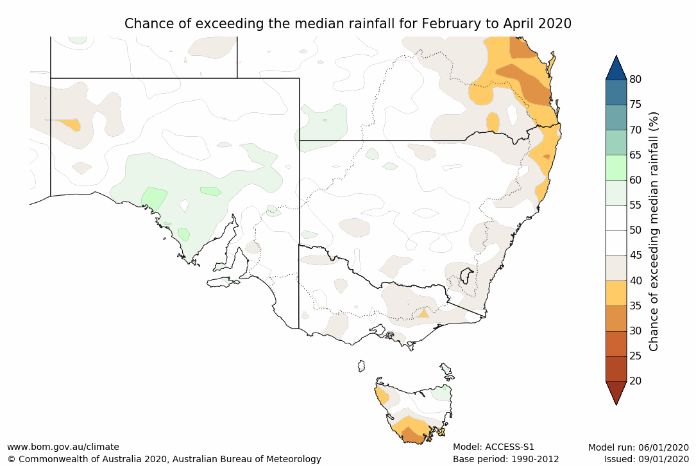
STORAGE VOLUMES
Murray-Darling Basin Storage Volumes
 Storage                    Full Supply Volume            15/1/2020               15/1/2019           Long-term
                                                                                                       average
                                    (GL)                     (GL)                    (GL)               (end of
                                                                                                       January)
                                                                                                          (GL)
 Dartmouth                                  3 856             1 965 (51%)             2 657 (69%)

 Hume                                       3 003               642 (21%)             1 056 (35%)

 Lake Victoria                                677               363 (54%)               475 (70%)

 Menindee Lakes                             *1 731                  7 (0%)                  54 (3%)

 TOTAL                                      9 267             2 977 (32%)             4 242 (46%)     6 343 (68%)
*Menindee Lakes can be surcharged to 2 015 GL

The below graph has been provided by the Murray-Darling Basin Authority. The graph shows the volume of water held in
the Murray-Darling Basin storages from June 2000 to now and the long-term average storage for the same period.

In December 2019, the Murray-Darling Basin Authority updated its River Murray System Annual Operating Outlook, which
provides comprehensive information on the system status and storage outlooks. The document can be accessed at
https://www.mdba.gov.au/publications/mdba-reports/river-murray-system-annual-operating-plan.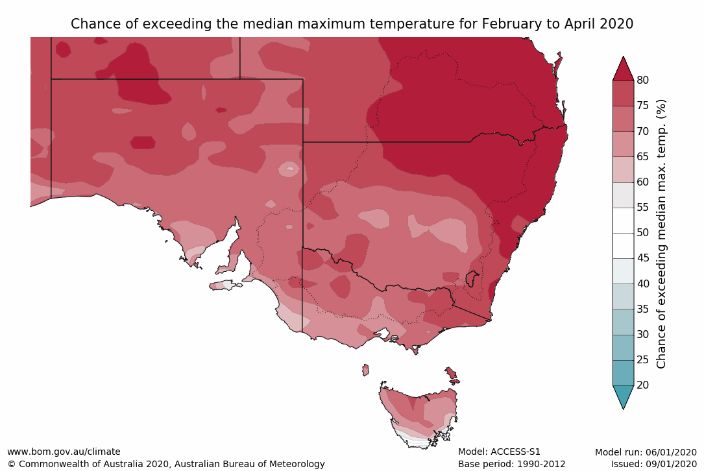
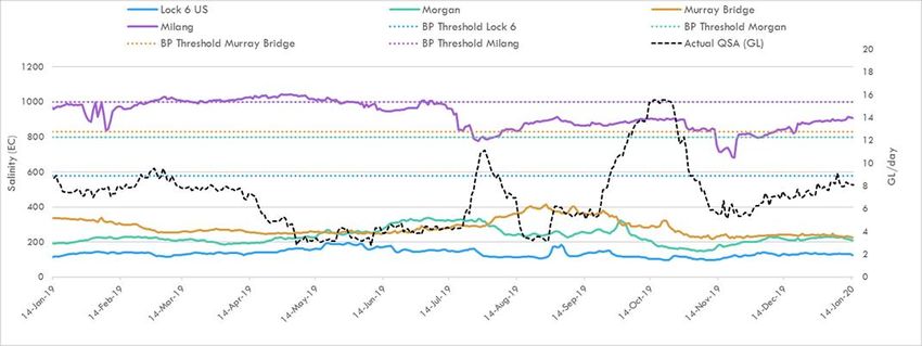
WATER QUALITY - Salinity
A number of targets are identified under the Murray-Darling Basin Plan, which all Basin jurisdictions must have regard to in
managing River Murray flows. The targets for real-time salinity are identified below. Salinity should not exceed these values
for 95% of the time:
580 EC at Lock 6
800 EC at Morgan
830 EC at Murray Bridge
1 000 EC at Milang.
The following graph shows the salinity at these locations and the flow to South Australia (QSA) from January 2019 to
January 2020. The dashed-lines identify the Basin Plan (BP) thresholds for the corresponding colour coded location.
SA River Murray Daily Average Salinity
FLOW OUTLOOK
It is likely that reduced Entitlement Flow will continue during the 2019-20 water year unless the water resource conditions
improve enough to provide South Australia with close to its full Entitlement Flow. In addition to the reduced Entitlement
Flow, South Australia will receive water for the environment.
The flow at the South Australian border is approximately 8.1 GL/day and will remain around this rate during the coming
week. It comprises:
January Entitlement Flow of 7 GL/day;
water for the environment (see below Water for the Environment); and
interstate trade adjustments.
The flow over Lock 1 is approximately 4 GL/day and will remain around this rate during the coming week, depending on
weather conditions and extractions.
It is important to note that flow forecasts in this advice are based on the information available at the time of preparation.
Advice may change as new gauging information becomes available or due to rainfall events or changed operations
upstream.
WATER FOR THE ENVIRONMENT
Water for the environment is currently being used to:
maintain connections through open fishways (at a minimum) between the Coorong, Lower Lakes and the River Murray
to enable fish movement;
maintain water quality and salinity levels below critical thresholds in the River Murray channel, Lower Lakes and
Coorong; and
deliver a range of outcomes to wetlands in the Riverland via arrangements with the South Australian Murray-Darling
Basin Natural Resources Management Board, Renmark Irrigation Trust, Banrock Station and the Nature Foundation
South Australia.MURRAY MOUTH Dredging operations at the Murray Mouth commenced on 9 January 2015 to maintain connectivity (exchange of water) between the Coorong and the Southern Ocean. At 12 January 2020, a total of approximately 5 217 534 cubic metres of sand had been removed by dredging operations. Two dredges are now operating between the Goolwa and Tauwitchere channels 24 hours a day, 7 days a week. Barrage releases combined with dredging have helped to maintain connectivity of the Murray Mouth. There are a number of shallow zones in and adjacent to the Murray Mouth. Mariners should use caution when traversing the mouth area, follow all directions, reduce speed and avoid travelling at low tide. Mariners equipped with echo sounders should check depths regularly. Navigation through the Murray Mouth is only permitted during daylight hours. Exclusion Zones established around the dredging operations are in place to ensure public safety. Refer to Notice to Mariners No 42 of 2016 Notice 42. There is a partial park closure in place for the northern tip of the Coorong National Park. For more information visit Coorong partial park closure notice. BARRAGE OPERATIONS AND WATER LEVELS IN THE LOWER LAKES The water level in Lake Alexandrina is approximately 0.57 m AHD and Lake Albert is approximately 0.55 m AHD. The difference in water level is due to wind effects. Water for the environment is enabling barrage releases (currently fishways only) to be undertaken for a longer period during summer. As of Tuesday 14 January 2020, the weekly releases were approximately 0.6 GL. During adverse weather conditions, SA Water will operate the barrages to minimise the risk of seawater entering Lake Alexandrina, therefore minimising any negative salinity impacts from reverse flow events. Water levels and barrage operations are monitored closely by the South Australian Government, Murray-Darling Basin Authority and Commonwealth Environmental Water Office. NAVIGATION ISSUES Sandbars in the vicinity of the Murray Mouth may cause navigation hazards. Mariners are advised to navigate with caution when operating in the area. Sandbars are also present along sections of the River Murray downstream of Locks 7 and 8 and in South Australia. All Mariners should be aware of the risk of submerged navigation hazards and should regularly check river depth. SOUTH AUSTRALIAN RIVERLAND FLOODPLAINS INTEGRATED INFRASTRUCTURE PROGRAM CONSTRUCTION WORKS Katarapko Construction works on the Katarapko Floodplain are underway and expected to be completed by mid-2020. Carparks Lagoon Regulator is the first structure at Katarapko to be completed. Other smaller structures at Piggy and Sawmill Creek are close to being completed. The blocking bank track is near completion with the park track rehabilitation and connections to the campsites underway. Work on the main regulator and fishway located at the Splash has progressed, with concrete slabs poured at the fishway and regulator piers, which hold up the structure. Some parts of the Murray River National Park are closed for camping and other recreational activities until approximately mid-2020. See the link for temporary park closure map Caring for Katarapko. For safety reasons, the following water access restrictions apply to river vessels and people (other than authorised personnel) until late March 2020: Sawmill Creek, the entire length between Katarapko Creek and Eckert’s Creek; and Eckert’s Creek, for 1.3 kilometres upstream of the confluence point with Katarapko Creek (ie The Splash). For more information or to receive regular updates about the Katarapko Floodplain Project please contact the Department for Environment and Water’s Engagement Officer, Ms Ellee Eleftheriadis on telephone: 8595 2148 or email: ellee.eleftheriadis2@sa.gov.au.
Pike
Although work on the regulating structures and blocking bank on the Pike Floodplain is now complete, other works
continue in this area. Vessels and persons other than those participating in the works are still prohibited from entering the
Pike River near the Rumpagunyah Creek and Tanyaca Creek junction, downstream of the Mundic Creek junction.

RIVER MURRAY WATER LEVELS
Below is a table of River Murray water levels at a number of locations from Lock 10 to Murray Bridge.

                                             River Murray Water Levels

         Location        River km        Normal          Current             1974               1993             2016
                                          Pool            Level             Flood              Flood          High Water
                                          Level        15/1/2020             Level              Level            Level
                                        (m AHD)         (m AHD)            (m AHD)            (m AHD)          (m AHD)
                           825.0          30.80           30.88              33.81              33.32            32.72
 Lock 10
                           764.8          27.40           27.41              30.03              29.44             28.85
 Lock 9 Kulnine
                           725.7          24.60           23.66              27.60              27.19             26.85
 Lock 8 Wangumma
                           696.6          22.10           21.65              25.70              25.24             24.97
 Lock 7 Rufus River
                           619.8          19.25           19.25              21.03              20.50             20.19
 Lock 6 Murtho
                           567.4            -             16.33              18.54              18.04             17.44
 Renmark
                           562.4          16.30           16.32              18.07              17.50             17.05
 Lock 5
                           537.8            -             13.28              16.85              16.26             15.80
 Lyrup
                           525.9            -             13.24              15.81              15.74             15.21
 Berri
                           516.2          13.20           13.23              15.65              15.08             14.73
 Lock 4
                           489.9            -             10.06              15.05              14.12             13.54
 Loxton
                           446.9            -              9.86              13.44              12.38             11.59
 Cobdogla
                           431.4           9.80            9.81              13.16              12.02             10.98
 Lock 3
                           425.9            -              6.25              12.73              11.58             10.41
 Overland Corner
 Waikerie                  383.6            -              6.23              11.26              10.24             9.20
                           362.1           6.10            6.13              10.28               9.30             8.32
 Lock 2
                           332.6            -              3.34               9.17               8.08             7.01
 Cadell
                           321.7            -              3.29               8.85               7.65             6.38
 Morgan
                           274.2           3.20            3.21               6.81               5.38             4.46
 Lock 1 Blanchetown
                           245.0           0.75            0.70               6.06               4.51             3.11
 Swan Reach
                           149.8           0.75            0.72               3.15               1.90             1.33
 Mannum PS
                           115.3           0.75            0.66               2.06               1.26             1.04
 Murray Bridge
                         Note that the above water levels may be affected by local wind conditions
FURTHER INFORMATION The WaterConnect website is South Australia’s comprehensive water information portal. For real-time data (like salinity, water levels) go to the following page: WaterConnect Real-time water data. Up-to-date River Murray salinity, flow and water level information can be accessed at the Department for Environment and Water, SA Water and Murray-Darling Basin Authority websites: Water allocation and carryover announcements River Murray real-time water data SA Water River Murray info - levels, flows etc. Murray-Darling Basin real-time water data The latest news, information and announcements about the River Murray and Basin Plan are available at River Murray Update. The Department for Environment and Water has published a series of inundation maps for the River Murray. They are available at River Murray Inundation Maps. Information on the management of acid drainage water in the Lower River Murray can be accessed at: Acid drainage water LMRIA Details of river height and rainfall information in the River Murray within Victoria and New South Wales are available at the Bureau of Meteorology website: Victoria rainfall and river conditions NSW rainfall and river conditions Information provided by the Commonwealth Environmental Water Office can be accessed at CEWH Environmental Watering. Information on The Living Murray can be accessed at MDBA TLM. Chowilla Floodplain Icon Site management Chowilla-floodplain. Department for Environment and Water Home page. Information provided by the Department of Planning, Transport and Infrastructure on boat licences, registering motor boats, owning and operating water craft, and boat and marine safety can be accessed at Boating and marine. ID RM-Flow-Report 20200117 Classification Public I2 A2 Issued 17 January 2020 Authority DEW Master Document Location R:\Water Group\RMO\WRO\04 Communications\Flow Advices\2019-20 Managed and Maintained by Water Infrastructure and Operations Branch Author Water Infrastructure and Operations Branch Reviewer Director, Water Infrastructure and Operations
You can also read