River Murray Weekly Report
←
→
Page content transcription
If your browser does not render page correctly, please read the page content below
River Murray Weekly Report
For the week ending Wednesday, 1 July 2020
Trim Ref: D20/21279
June 2020 summary
The Bureau of Meteorology (BoM) reports that June 2020, for Australia as a whole, was the third-warmest June on
record. For the Murray-Darling Basin, maximum temperatures were mostly average to above average, yet minimum
temperatures were mostly average to below average (Map 1 & 2).
For most of the Murray-Darling Basin, June rainfall was 34 per cent below the average (Map 3 & 4), and it was the
21st driest June on record. There was continued reasonable rain recorded across the southern and eastern ranges
and catchments, particularly through NSW and north-eastern Victoria. Elsewhere it was fairly dry, especially across
most of the western part of the basin. The central basin recorded between 10 and 25 mm for the month and the
southern ranges recorded near average rainfall.
River Murray system inflows for June 2020 (excluding environmental, IVT and Snowy scheme contributions) totalled
around 650 GL, which is 32% AEP (annual exceedance probability).

Map 1 & 2 – Minimum and maximum June 2020 temperature deciles for Australia. Source: Bureau of Meteorology.

Map 3 & 4 – Murray-Darling Basin rainfall and rainfall deciles for June 2020. Source: Bureau of Meteorology.

     Subscribe to the River Murray Weekly Report                      River Data website                       Water in Storages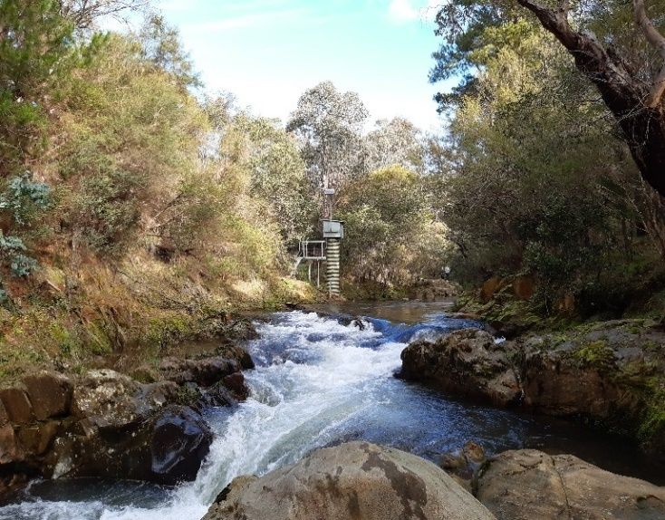
River Murray Weekly Report

Rainfall and inflows
There was only light rainfall across the southern Murray-Darling Basin this week, predominantly across Victoria
(Map 5). In upper northeast Victoria, Falls Creek and Mount Buller both recorded 7 mm while a little further west in
the same region, Jamieson recorded 6 mm. Elsewhere in the basin, conditions remained mostly dry.
Stream flows in the upper and mid-Murray tributaries continue to recede following the rainfall in the preceding
week, however tributary inflows from the Ovens and Kiewa Rivers remained sufficient to meet downstream flow
requirements this week. The Bureau of Meteorology (BoM) is currently forecasting light to moderate rainfall totals
over the southern Murray-Darling Basin in the coming 8 days that are expected to maintain reasonable tributary
inflows over the coming week.

Map 5 - Murray-Darling Basin rainfall totals for week ending 1 July (Source: Bureau of Meteorology)

Specific information about flows at key locations can be found at the MDBA’s River Murray data webpage. Up-to-
date river data for sites in the upper Murray can also be found on BoM’s website and in the Murray River Basin
Daily River Report at the WaterNSW website.

     Subscribe to the River Murray Weekly Report                     River Data website               Water in Storages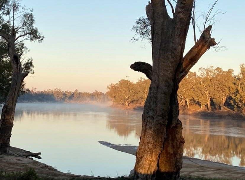
River Murray Weekly Report

System operations
Unregulated flow event
Despite releases from Hume Dam remaining at the minimum flow, recent inflows from the Ovens, Kiewa and
Goulburn Rivers have resulted in sustained elevated flows through the mid-Murray and the capture of around 200
GL in Lake Victoria since the beginning of June. Lake Victoria has now exceeded 89% capacity and the storage is
forecast to fill with sufficient surplus flow remaining to extend the period of unregulated flow that was declared on
26 June (and commenced on 27 June). For more information on the expected duration and the river reaches where
unregulated flow currently applies, refer to your local water authority.
In the Murrumbidgee system, this week WaterNSW announced an extension of access to supplementary water for
the Murrumbidgee River and Yanco/Billabong Creek Systems. For more information, please refer to the WaterNSW
website.

River operations
      •   Minimum releases from Hume Dam continue as tributary inflows exceed downstream
          requirements
      •   Lake Victoria continues to rise
      •   Unregulated flow event extended

River operations and the COVID-19 virus
The MDBA is continuing to work with government partners and stakeholders during this challenging time. In
response to the impact of COVID-19, the MDBA has enacted business continuity arrangements to ensure the
continued operation of our business functions. River operations have been identified as a priority in this time as
running the river is essential to supporting irrigation supply to agricultural industries.
We hope all our community members remain safe at this time. We encourage all river users to evaluate plans
against government advice, social distancing and travel, and to support actions to limit the spread of COVID-19.
Water quality impacts
A number of amber alerts for blue-green algae remain current in the River Murray system. It is important that
water users regularly keep up to date with algal alerts, notices and health warnings. This information is available
through Goulburn-Murray Water and WaterNSW.
River operations
Over the past week, MDBA total active storage (Dartmouth, Hume and Lake Victoria) increased by 148 GL to
3,570 GL (42% capacity).
At Dartmouth Reservoir, the storage increased by 19 GL to 2,008 GL (52% capacity). The release from Dartmouth,
measured at Colemans, targeted 1,200 ML/day until Saturday for the purposes of electricity generation. From
Saturday morning, the flow began to decrease to the minimum flow around 200 ML/day, which was reached on
Sunday morning, and continued at this rate for the remainder of the week. It is expected that the flow will continue
to target the minimum over the coming week.
At Hume Reservoir, the storage increased by 89 GL to 1,155 GL (38% capacity) and is expected to continue to rise in
response to light rainfall totals in the upper Murray catchment during the week building on elevated tributary
inflows from moderate to high rainfall totals in the preceding week. Downstream of Hume, elevated tributary
inflows following sustained light rainfall have been sufficient to meet and exceed downstream flow requirements,
and the release from Hume is continuing at the minimum requirement of 600 ML/day.

     Subscribe to the River Murray Weekly Report              River Data website                    Water in Storages
River Murray Weekly Report
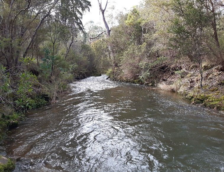
Photos 1 and 2: Gauging station on Morses Creek (left), and view downstream (right), Ovens Catchment
(Image courtesy Hugo Bowman, MDBA)
At Lake Mulwala, the pool level is currently 124.72 m AHD, which is within the normal operating range between
124.6 and 124.9 m AHD. At Yarrawonga Weir, flow increased at the start of the week from 10,000 ML/day to a peak
of around 11,000 ML/day to pass inflows arriving from the preceding week’s rain. On Monday the release began to
decrease and is currently at around 8,500 ML/day and expected to continue to reduce over the coming week.
As Yarrawonga releases remained above 9,000 ML/day (approximate downstream channel capacity) for most of the
week, some forest regulators in the Millewa Forest remained open to manage river levels. It is likely these
regulators will gradually be closed over the next week as river levels fall below channel capacity.
The gates at Edward and Gulpa Creek offtake regulators were previously raised clear of the water, allowing inflows
to the Edward River to vary with the Murray. This week, as Murray flows gradually increased, the gates have been
reinstated to manage flows near 1,550 ML/day and around 220 ML/day, respectively. At Stevens Weir, the
downstream flow averaged around 1,160 ML/day and is expected to remain at about this rate for the coming week.
Back on the River Murray, the flow at Barmah increased from around 5,800 ML/day to the current rate near
6,500 ML/day. Over the coming week, the flow is expected to gradually decrease. Inflows from the Broken Creek,
measured at Rice’s Weir, averaged around 30 ML/day this week.
On the Goulburn River, the flow measured at McCoys Bridge peaked during the week at around 8,500 ML/day and
has since eased to around 5,900 ML/day. With the Waranga Basin now at its winter target level, all Goulburn
tributary inflows entering the river downstream of Lake Eildon will flow through to the Murray. Variations in flow
will therefore reflect rainfall and streamflow responses in the Goulburn catchment.
Diversions to National Channel from the Torrumbarry Weir pool continued to remain steady this week, averaging
around 420 ML/day. Whilst diversions for irrigation have now ceased, water is expected to continue to be diverted
at around this rate over coming weeks to maintain baseflows in the Gunbower Creek. Having been lowered over the
past few weeks, the Torrumbarry Weir pool has reached its target level of around 30 cm below the Full Supply Level
(FSL). The pool will now be varied between 20-30 cm below FSL over the coming months as part of the weir pool
variability program. Varying pool levels assists with reducing the incidence of notching and can help improve bank
stability for riverbanks within the influence of the weir pool. The release from Torrumbarry Weir gradually increased
from near 11,000 ML/day to the current rate of around 14,300 ML/day, as peak inflows from the Goulburn River
combined with higher upstream Murray flows following rain in the preceding weeks passed. Flows are expected to
gradually decrease in the coming week.
Subscribe to the River Murray Weekly Report River Data website Water in StoragesRiver Murray Weekly Report
Inflow from the Murrumbidgee River, measured at Balranald, averaged around 1,050 ML/day this week. These
elevated flows at Balranald have resulted from rain and the drawing down of various weir pools in the
Murrumbidgee system for winter maintenance purposes. The Murrumbidgee IVT balance is open for trade from
both the Murrumbidgee to the Murray (51.5 GL), and from the Murray to the Murrumbidgee (48.5 GL).
At Euston Weir, the weir pool level is targeting around 30 cm below FSL as part of the weir pool variability program.
The downstream release averaged around 11,500 ML/day this week and is expected to gradually increase over the
coming week.
This week the Menindee Lakes storage decreased slightly by 2 GL to 479 GL (28% capacity) from the Lakes’ peak
level of just under 481 GL. WaterNSW has been providing regular updates on the streamflow response in the
Barwon-Darling system. Inflows into the Menindee Lakes have reduced to low levels. WaterNSW has ceased the
transfer of water from Lake Wetherell to Lake Pamamaroo (now storing around 330 GL) as the two lakes have
reached parity in level. The downstream release, measured at Weir 32, averaged around 240 ML/day over the past
week. Despite the rainfall and streamflow responses during recent months, in many parts of NSW drought
conditions persist with extensive water restrictions still in place. Links to drought services and assistance can be also
accessed via the MDBA drought webpage.
At Wentworth Weir, the weir pool level is being managed to a target level around FSL (30.80 m AHD) but is
expected to vary 10 cm above and below this level as part of normal operations. The downstream release decreased
gradually this week, from around 11,900 to 9,900 ML/day and is expected to gradually increase again over the
coming week.
Photo 3: The River Murray at Hattah National Park, Mallee Catchment (Image courtesy Janice Burgess)
Subscribe to the River Murray Weekly Report River Data website Water in StoragesRiver Murray Weekly Report
At Lock 9, the pool level remains surcharged to manage the inflow of water into Lake Victoria, but the pool may
return to FSL over the coming week as the rate of fill of the Lake continues to slow.
This week, the Lake Victoria storage volume increased by 41 GL to 601 GL (89% capacity). Over the week, diversions
into Lake Victoria were steadily reduced from around 8,500 ML/day to near 5,000 ML/day. Similar or slightly
reduced inflows are expected over the coming week. These inflows are being managed to continue raising the
storage level towards full, but at a more gradual rate over the coming week. The storage level in Lake Victoria will
continue to be managed over the coming weeks in accordance with the Lake Victoria Operating Strategy. The aim
will be to fill the storage, whilst helping to minimise erosional and inundation impacts on sensitive foreshore
vegetation and cultural heritage material.
The flow to South Australia increased from around 3,700 ML/day to 5,300 ML/day this week, as unregulated flows
increased across the border. Flow to South Australia is expected to continue to increase in coming weeks with the
arrival of high flows from upstream. For more information on South Australia’s Entitlement flow, see the South
Australian Department for Environment and Water’s latest River Murray flow report.
The Lower Lakes 5-day average water level is currently 0.67 m AHD. Releases have continued through fishways,
with opportunistic releases through Tauwitchere barrage when tide and wind conditions permit. The variable
barrage release strategy will continue to target the incoming high tide window in order to push fresh water along
the Coorong. For information on barrage releases see the South Australian Department for Environment and Water
Weekly River Murray Flow Report.
For media inquiries contact the Media Officer on 02 6279 0141
ANDREW REYNOLDS
Executive Director, River Management
Subscribe to the River Murray Weekly Report River Data website Water in StoragesRiver Murray Weekly Report
Water in Storage Week ending Wednesday 01 Jul 2020
Full Full Current Change in Total
Dead Active
MDBA Storages Supply Supply Storage Current Storage Storage for the
Storage Storage
Level Volume Level Week
(m AHD) (GL) (m AHD) (GL) % (GL) (GL) (GL)
Dartmouth Reservoir 486.00 3 856 452.13 2 008 52% 71 1 937 +19
Hume Reservoir 192.00 3 005 180.19 1 155 38% 23 1 132 +89
Lake Victoria 27.00 677 26.37 601 89% 100 501 +41
Menindee Lakes 1 731* 479 28% (- -) # 0 -2
Total 9 269 4 243 46% -- 3 570 +148
Total Active MDBA Storage 42% ^
Major State Storages
Burrinjuck Reservoir 1 026 448 44% 3 445 +5
Blowering Reservoir 1 631 940 58% 24 916 +48
Eildon Reservoir 3 334 1 622 49% 100 1 522 +39
* Menindee surcharge capacity – 2050 GL ** All Data is rounded to nearest GL **
# NSW has sole access to water when the storage falls below 480 GL. MDBA regains access to water when the storage next reaches 640 GL.
^ % of total active MDBA storage
Snowy Mountains Scheme Snowy diversions for week ending 30 Jun 2020
Storage Active Storage (GL) Weekly Change (GL) Diversion (GL) This Week From 1 May 2020
Lake Eucumbene - Total 921 -10 Snowy-Murray +16 250
Snowy-Murray Component 439 n/a Tooma-Tumut +7 63
Target Storage 1 170 Net Diversion 9 186
Murray 1 Release +25 317
Major Diversions from Murray and Lower Darling (GL) *
New South Wales This Week From 1 July 2020 Victoria This Week From 1 July 2020
Murray Irrig. Ltd (Net) 0.4 0 Yarrawonga Main Channel (net) 0 0
Wakool Sys Allowance 0.8 0 Torrumbarry System + Nyah (net) 0 0
Western Murray Irrigation 0.2 0 Sunraysia Pumped Districts 0.6 0
Licensed Pumps 0.9 0 Licensed pumps - GMW (Nyah+u/s) 2.8 0
Lower Darling 0.1 0 Licensed pumps - LMW 0.8 0
TOTAL 2.4 0 TOTAL 4.2 0
* Figures are derived from actual and estimates where data is unavailable. Please note that not all data may have been available at the time of creating
this report. ** All data above is rounded to nearest 100 ML for weekly data and nearest GL for cumulative data
Flow to South Australia (GL) Entitlement this month 108.5 *
* Flow to SA will be greater than normal entitlement for Flow this week 28.9 (4 100 ML/day)
this month due to some environmental flows and
Flow so far this month 5.3
unregulated flows crossing the SA border.
Flow last month 104.8
Salinity (EC) (microSiemens/cm at 25o C)
Current Average over the last week Average since 1 August 2019
Swan Hill 110 120 70
Euston - - -
Red Cliffs 110 100 50
Merbein 100 100 100
Burtundy (Darling) 300 290 600
Lock 9 100 90 100
Lake Victoria 100 120 120
Berri 210 200 160
Waikerie 310 250 220
Morgan 290 280 230
Mannum 250 250 260
Murray Bridge 330 320 290
Milang (Lake Alex.) 960 990 900
Poltalloch (Lake Alex.) 650 670 800
Meningie (Lake Alb.) 1 730 1 750 1 770
Goolwa Barrages 4 330 5 170 3 080
Subscribe to the River Murray Weekly Report River Data website Water in StoragesRiver Levels and Flows Week ending Wednesday 01 Jul 2020
Minor Flood Average Flow this Average Flow last
Gauge Height Flow Trend
Stage Week Week
local (m
River Murray (m) (m) AHD) (ML/day) (ML/day) (ML/day)
Khancoban - - - 3 330 F 4 730 3 860
Jingellic 4.0 2.08 208.60 7 900 F 9 600 10 750
Tallandoon ( Mitta Mitta River ) 4.2 1.67 218.56 1 200 F 1 760 1 690
Heywoods 5.5 1.49 155.12 600 S 600 600
Doctors Point 5.5 1.75 150.22 2 490 F 2 970 3 340
Albury 4.3 0.89 148.33 - - - -
Corowa 4.6 0.93 126.95 2 810 F 3 270 2 940
Yarrawonga Weir (d/s) 6.4 1.48 116.52 9 010 F 10 630 8 500
Tocumwal 6.4 2.25 106.09 10 330 F 10 600 7 360
Torrumbarry Weir (d/s) 7.3 4.24 82.79 14 500 R 12 860 8 570
Swan Hill 4.5 2.15 65.07 12 320 R 10 880 8 290
Wakool Junction 8.8 3.83 52.95 12 040 R 10 830 10 520
Euston Weir (d/s) 9.1 2.15 43.99 12 480 R 11 450 12 260
Mildura Weir (d/s) - - 10 950 F 11 120 12 100
Wentworth Weir (d/s) 7.3 3.26 28.02 9 900 S 10 430 11 290
Rufus Junction - 3.20 20.13 4 990 R 3 550 2 800
Blanchetown (Lock 1 d/s) - 0.64 - 4 060 R 3 000 2 800
Tributaries
Kiewa at Bandiana 2.8 1.97 155.20 1 940 F 2 410 2 720
Ovens at Wangaratta 11.9 9.51 147.19 5 060 F 6 150 6 460
Goulburn at McCoys Bridge 9.0 4.30 95.72 6 850 F 7 560 5 280
Edward at Stevens Weir (d/s) 5.5 1.33 81.11 1 070 F 1 160 830
Edward at Liewah - 1.45 56.83 820 F 940 1 050
Wakool at Stoney Crossing - 1.35 54.84 340 F 510 640
Murrumbidgee at Balranald 5.0 1.50 57.46 1 080 R 1 050 950
Barwon at Mungindi 6.1 3.20 - 130 R 130 130
Darling at Bourke 9.0 3.98 - 60 F 60 100
Darling at Burtundy Rocks - 0.70 - 150 F 160 170
Natural Inflow to Hume 13 310 18 310
(i.e. Pre Dartmouth & Snowy Mountains scheme)
Weirs and Locks Pool levels above or below Full Supply Level (FSL)
Murray FSL (m AHD) u/s d/s FSL (m AHD) u/s d/s
Yarrawonga 124.90 -0.16 - No. 7 Rufus River 22.10 +0.11 +0.89
No. 26 Torrumbarry 86.05 -0.26 - No. 6 Murtho 19.25 -0.00 +0.08
No. 15 Euston 47.60 -0.28 - No. 5 Renmark 16.30 +0.06 +0.26
No. 11 Mildura 34.40 +0.01 +0.32 No. 4 Bookpurnong 13.20 +0.16 +0.60
No. 10 Wentworth 30.80 +0.00 +0.62 No. 3 Overland Corner 9.80 +0.16 +0.30
No. 9 Kulnine 27.40 +0.22 -0.43 No. 2 Waikerie 6.10 +0.14 +0.23
No. 8 Wangumma 24.60 -0.53 +0.23 No. 1 Blanchetown 3.20 +0.13 -0.11
Lower Lakes FSL = 0.75 m AHD
Lake Alexandrina average level for the past 5 days (m AHD) 0.67
Barrages Fishways at Barrages
Openings Level (m AHD) No. Open Rock Ramp Vertical Slot 1 Vertical Slot 2 Dual Vertical Slots
Goolwa 128 openings 0.73 1 - Closed Open -
Mundoo 26 openings 0.70 All closed - - - Open
Hunters Creek - - - - Open - -
Boundary Creek 6 openings - All closed - Open - -
Ewe Island 111 gates - All closed - - - Open
Tauwitchere 322 gates 0.73 2 Open Open Open -
AHD = Level relative to Australian Height Datum, i.e. height above sea level
Subscribe to the River Murray Weekly Report River Data website Water in StoragesWeek ending Wednesday 01 Jul 2020
State Allocations (as at 01 Jul 2020)
NSW - Murray Valley Victorian - Murray Valley
High security 97% High reliability 8%
General security 0% Low reliability 0%
NSW – Murrumbidgee Valley Victorian - Goulburn Valley
High security 95% High reliability 35%
General security 10% Low reliability 0%
NSW - Lower Darling South Australia – Murray Valley
High security 100% High security 54%
General security 30%
NSW : https://www.industry.nsw.gov.au/water/allocations-availability/allocations/summary
VIC : http://nvrm.net.au/seasonal-determinations/current
SA : https://www.environment.sa.gov.au/topics/river-murray/water-allocations-and-announcements
Subscribe to the River Murray Weekly Report River Data website Water in StoragesYou can also read