Road Management Plan 2021 - Prepared by Macedon Ranges Shire Council
←
→
Page content transcription
If your browser does not render page correctly, please read the page content below

Road Management Plan
     2021

Prepared by Macedon Ranges Shire Council

                                           Page 1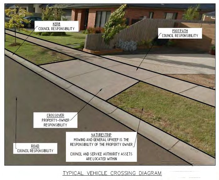
Contents

Definitions ................................................................................................................................................ 4
Introduction .............................................................................................................................................. 5
Macedon Ranges Shire Council’s Road Network .................................................................................... 5
Objectives of this Road Management Plan .............................................................................................. 6
Council’s suite of plans, strategies and polices ....................................................................................... 6
Road Management Plan Scope ............................................................................................................... 6
Asset Management Plans ........................................................................................................................ 7
The Road Asset Management Plan ......................................................................................................... 7
Key Stakeholders .................................................................................................................................... 7
Road Management Act 2004 ................................................................................................................... 8
How the Road Management Act affects the community1 ......................................................................... 8
Demand and Growth................................................................................................................................ 9
Funding Sources ..................................................................................................................................... 9
Driving on the Road ................................................................................................................................. 9
Access to Private Property .................................................................................................................... 10
Utility Infrastructure and Service Providers ............................................................................................ 11
Register of Public Roads ....................................................................................................................... 11
Pathway Register .................................................................................................................................. 11
Road Hierarchy...................................................................................................................................... 11
Demarcation and Transfer of Responsibility .......................................................................................... 12
Boundary Roads .................................................................................................................................... 13
Other Agreements ................................................................................................................................. 13
Council’s Road Infrastructure Network Classifications........................................................................... 14
Table 1.1 Council’s Local Road Network ............................................................................................... 14
Table 1.2 Council’s Pathway Network Hierarchy ................................................................................... 15
Key Facts............................................................................................................................................... 15
Table 2: Macedon Ranges Shire Council’s Road Assets....................................................................... 15
Service Levels for Road Infrastructure and Road Related Infrastructure ............................................... 16
Customer Expectations.......................................................................................................................... 16
Risk Management Framework ............................................................................................................... 17
Minimising Risk ...................................................................................................................................... 17
Inspections ............................................................................................................................................ 17

                                                                                                                                              Page 2
Operational, Routine Maintenance and Renewal Programs .................................................................. 18
Routine Maintenance Schedules ........................................................................................................... 19
Register of Public Roads ....................................................................................................................... 19
Intervention Levels................................................................................................................................. 19
Customer Requests System .................................................................................................................. 20
Monitoring Asset Performance .............................................................................................................. 20
Exceptional Circumstances ................................................................................................................... 20
Monitoring and Review .......................................................................................................................... 20
References ............................................................................................................................................ 21
Performance Standards ......................................................................................................................... 22

                                                                                                                                          Page 3
Definitions
The RMA - Road Management Act, 2004.
Arterial Road – are main roads usually managed by VicRoads as defined under section 14 of the
RMA.
Council – means Macedon Ranges Shire Council.
Public Road – is a road declared a public road by Council under Section 17 of the Road Management
Act 2004 and listed on Council’s Public Road Register.
Non-Road Infrastructure - means infrastructure in, on, under or over a road which is not road
infrastructure, examples include gas pipes, water and sewerage pipes, cables, electricity poles
and cables, tram wires, rail infrastructure (including boom gates, level crossings and tram safety zones),
bus shelters, public telephones, mail boxes, roadside furniture and fences erected by utilities or providers
of public transport.
Road Infrastructure - the infrastructure which forms part of a roadway, pathway or shoulder.
Shared Path - is a path that is designated for use by pedestrians and cyclists.
Page 4Introduction
Council’s Road Management Plan has been developed in accordance with section 52 of the RMA, and
establishes Council’s road management system for road infrastructure and road related infrastructure as
defined under the RMA and for which Council is the relevant road authority. The plan has been developed
in line with Council’s obligations under the RMA and Wrongs Act, 1958 with consideration given to
resource availability and operational objectives.
Macedon Ranges Shire Council’s Road Network
Macedon Ranges Shire Council (MRSC) records details of 1765 kilometres of roads and access tracks
in the corporate asset register. Approximately 1570 kilometres of roads are listed on Council’s Register
of Public Roads (Sealed 840km, Un-sealed 730km).and this makes up the bulk of the local road network
provided by Council. Council maintains a further 97km of roads including: roads within reserves and
facilities (30km); and fire access tracks (67km) though these are subjected to a less stringent inspection
and maintenance regime than those roads on the Public Road Register. The remaining 98km of roads
that are not maintained by Council include access tracks to private properties (28km); Fire Access Tracks
maintained by others (47km); and Public Roads maintained by neighbouring shires under agreement with
MRSC (23km).
Public
Length
Road Road Type
(km)
Register
Yes Sealed Roads 840
Yes Unsealed Roads 730
Sub-Total 1570
No Shared Shire Boundary Roads on Neighbouring Shire Public Road Register 23
No Roads within Reserves and Facilities 30
No Unsealed Roads - Not Maintained 28
No Fire Access Tracks - Seasonally Maintained 67
No Fire Access Tracks - Unmaintained or Private Property 47
Sub-Total 195
Total 1765
The local transport network also includes 203km of footpaths, 325km of kerb and channel, 143 bridges
and major culverts and 62 footbridges.
Page 5Objectives of this Road Management Plan
The objectives of this Road Management Plan are to:
• Provide an overview of the management system used to carry out Council’s road management
functions, as a responsible road authority under the RMA, and with regard to management and
operational objectives and available resources;
• Set the relevant standard in relation to the discharge of duties of the Council in the performance of
those road management functions.
• Aim to provide a safe and efficient network of municipal public roads primarily for travel and transport.
It is intended that this document provide sufficient information to enable Council and the community to
fully appreciate the value of its road assets and associated activities to manage risk across the municipal
road network. This document is intended to provide a simple easy to understand overview of Council’s
road management system and responsibilities as required under the RMA.
Road Management Plan Scope
This Plan covers all roads for which MRSC is responsible but concentrates on those roads listed in
Council’s ‘Register of Public Roads’. It is limited to road infrastructure and road related infrastructure as
defined under the RMA and for which Council is the relevant road authority. The assets covered include:
• Road pavement and surface;
• On-street car parking;
• Off-street Council owned car parks;
• Traffic control devices;
• Paths;
• Shared Paths;
• Bridges (only the road pavement, surface and footpath components. Other bridge components are
managed in accordance with Council’s Bridge Asset Management Plan); and
• Culverts, table drains and drainage pits.
Examples of infrastructure not included in this plan include:
• Underground drainage pipes;
• Roadsides (Council is currently preparing a Roadside Conservation Management Plan which
refers to management standards for this area of the road reserve);
• Sub and Super Structures of Bridges;
• Vehicle crossings providing access to private properties; and
• Non-road infrastructure.
Various utilities make use of the road reserve to provide essential services. These are normally
considered to the extent that they impact on the road assets.
Page 6Asset Management Framework
Council has an asset management framework consisting of Policy, Strategy, and Plans that provide long
term strategic management of Council’s various asset categories.
The Road Asset Management Plan
The MRSC Road Asset Management Plan (RAMP) is a cornerstone document of the Asset Management
Framework and is separate to the Road Management Plan. The RAMP guides the long term strategic
management of Council’s road assets. The RAMP is reviewed every three years to provide assurance
to Council, ratepayers and other stakeholders, that road assets are being managed efficiently and
sustainably.
The RAMP is a detailed and comprehensive document that is used on a regular basis by Council staff to
assist prioritisation of work and implementation of asset management goals.
The RAMP delivers a considered and planned approach to the long-term management of road assets by
providing guidance on the short, medium, and long term investment required, by council, to maintain
current levels of service to the community.
The RAMP links with other Council plans, policies and strategies to guide the implementation of works
programs, and includes a summary of roads and related assets and a description of the road hierarchy.
Key Stakeholders The key stakeholders for the Road Management Plan include:
• State and Federal Governments;
• Councillors (As representatives of the community);
• Ratepayers;
• Residents;
• Road Users;
• Visitors;
• Utilities;
• Developers;
• Employees;
• Special Interest Groups;
• Contractors/Suppliers; and
• Others.
Page 7Road Management Act 2004 1
The Road Management Act 2004 (RMA – as amended) was passed on May 11 2004. The RMA was
developed to provide an efficient and safe Victorian road network, and was the result of extensive
stakeholder and community consultation.
The RMA is based on the following key principles:
• clear allocation of road asset ownership and management;
• established processes and accountabilities for policy decisions and performance standards;
• provision of operational powers to achieve targets and performance standards; and
• Clarification of civil liability laws for the management of roads.
How the Road Management Act affects the community1
The RMA affects the Victorian community in the following ways, it:
• Confirms the right of members of the public to travel on roads, and the right of property owners or
occupiers of adjoining land to have access to the road;
• Provides an efficient and safe road network across Victoria;
• Provides roads that best meet the needs and priorities of the community;
• Clarifies the allocation of responsibility between road authorities for managing the different parts of
the road reserve;
• Clearly defines the powers and obligations in regard to traffic management, the management of
access to roads, road works by service authorities, and maintenance of public transport infrastructure
within road reserves;
• Continues to provide municipalities with responsibility for parking on arterial roads;
• Provides for VicRoads to implement clearways on arterial roads, subject to consultation with Councils,
affected land owners/occupiers, traders and the community in accordance with a Code of Practice;
• Imposes a limit in relation to liability for property damage or economic loss by way of setting a
threshold amount (indexed annually). A road authority is not liable for property damages where the
value of the damage is equal to or less than the threshold amount; and
• Minimises disruption to traffic and ensure the safety of road users as a result of service authorities
and others undertaking works on roads.
1
VicRoads Fact Sheet “The Road Management Act at a glance for the community”.
Page 8Demand and Growth
The Macedon Ranges Shire population forecast for 2021 is 51,020 and is forecast to grow to 65,405 by
2036 (http://forecast.id.com.au/macedon-ranges). This growth in population will put pressure on existing
road infrastructure and will result in the need for more road assets.
Funding Sources
The current funding sources available for the management of Macedon Ranges Shire Council road asset
infrastructure include:
• Roads to Recovery – this is a fixed allocation by the Australian Government in four year blocks with
no guarantee of continuance (Federal);
• Grants Commission – roads component of grant commission funding;
• Rate Revenue (capped at CPI)
• Black Spot/Length funding;
• Special Charge Scheme for Infrastructure Works; and
• Private developer funded works.
Driving on the Road
The obligations of road users are set out in Section 17A of the Road Safety Act 1986 (as amended by
the Road Management Act 2004) and are summarised below:
A person who drives a motor vehicle on a highway A road user other than a person driving a motor vehicle must
must drive in a safe manner having regard to all use a highway in a safe manner having regard to all the
relevant factors including (but not limited to) the: relevant factors.
a) Physical characteristics of the road;
b) Prevailing weather conditions; A road user must have regard to the rights of other road
c) Level of visibility; users and the community, taking reasonable care to avoid
d) Condition of the motor vehicle; conduct that may:
e) Prevailing traffic conditions; a) Endanger the safety and welfare of themselves or
f) Relevant road laws and advisory signs; other road users;
g) Physical and mental condition of the driver. b) Damage any infrastructure on the road reserve;
c) Harm the environment of the road reserve.
Page 9Access to Private Property
The RMA provides that Council is not liable for private vehicle crossings specifically required for property
access. The landowner is responsible for these assets and for ensuring the vehicle crossing, including
the immediate surrounds that the vehicle crossing impacts on is maintained in a safe condition.
All properties are required to have a vehicle crossing for access to and from the road and the landowner,
has a responsibility to ensure that the crossing does not present a hazard. The construction of a vehicle
crossing must be carried out to Council’s standards. Landowners require a permit from Council prior to
the commencement of any modification or construction work.
A Council representative will inspect the works in accordance with Council’s Asset Protection Policy.
Where modifications to the Council’s assets (e.g. paths and kerb and channel) are required, these shall
be at the landowner’s expense.
The diagrams below illustrate the responsibility for associated infrastructure for private vehicle crossings.
Page 10Utility Infrastructure and Service Providers
The RMA affects utility infrastructure and service providers in a number of ways. Specific obligations are
set out in Schedule 7 of the RMA and under the RMA Code of Practice entitled ‘Management of
Infrastructure in Road Reserves’.
Register of Public Roads
Macedon Ranges Shire Council maintains a Register of Public Roads in accordance with Section 19 of
the RMA. The register is located on Council’s website:
https://www.mrsc.vic.gov.au/About-Council/Our-Council/Strategies-Plans/Public-Road-Register
Public roads are defined in Section 17 of the RMA. Section 17 also enables a road to gain the status of
a public road if the road authority deems the road to be reasonably required for general public use.
MRSC determines whether or not a road is reasonably required for general public use using the Public
Road Procedure. Which is located on council’s website:
https://www.mrsc.vic.gov.au/About-Council/Our-Council/Strategies-Plans/Public-Roads-Procedure
Under the RMA the determination that a road is not reasonably required for general public use does not
affect the status of the road as a public highway or affect the right of public use of the public highway.
Macedon Ranges Shire Council’s ‘Register of Public Roads’ defines the roads for which Council is the
responsible road authority. This register also identifies the functional road hierarchy category for each
road, which forms the basis for all operations and maintenance management activities. For each road (or
street), the Register of Public Roads records the:
• Road Name;
• Location/Segment Details; and
• Road Register Classification.
This register is updated regularly and can be inspected at Council’s Administration Centres or
downloaded from the Council website at www.mrsc.vic.gov.au.
Pathway Register (Footpaths and Cycle ways)
A pathway register containing all of Council’s footpaths and cycle ways is maintained by Council in the
corporate asset register. The register defines the pathways for which Council is responsible and identifies
the functional pathway hierarchy for each section of pathway. This RMP defines the standards to which
the pathway network are maintained.
Road Hierarchy
The RMA categorises roads into three main classifications:
• Freeways (VicRoads responsibility)
• Arterial Roads (VicRoads responsibility)
• Local Roads (MRSC responsibility)
Page 11The local road network is made up of sealed and unsealed roads. The functional road hierarchy splits the
local road network into categories, as shown in Table 1.1
The pathway hierarchy splits the pathway network into two categories, as shown in Table 1.2.
The pathway hierarchy classification is different to that adopted for the roadway. It is based on the
pedestrian movements (volumes), location and the ‘pedestrian service level’.
The pathway hierarchy classification has regard to:
• the anticipated volume of pedestrians, for example, in the vicinity of a shopping centre, community
facility, or a railway station as compared to a largely residential area;
These functional road and pathway hierarchy categories are used to determine inspection frequencies,
maintenance regimes and standards for new construction.
Demarcation and Transfer of Responsibility
Council is not responsible for the following roads within the Shire:
• Arterial Roads and Freeways (these are controlled by VicRoads);
• Roads not included on the Register of Public Roads;
• Parks Victoria roads unless specifically agreed to by MRSC (these are controlled by the Department
of Environment, Land, Water and Planning);
• Roads on shire boundaries that are, by agreement, included on a neighbouring shire’s public road
register;
• Roads or tracks located on private property.
The RMA Code of Practice entitled ‘Operational Responsibility for Public Roads’ (S 267 – 17 December
2004) provides further guidance regarding demarcation boundaries between responsible road authorities,
where local roads controlled by Councils intersect with Arterial Roads and Freeways controlled by
VicRoads.
Council is also not responsible for the following assets in the road reserve:
• Water services and mains;
• Sewerage services and mains;
• Gas services and mains;
• Telecommunication cables and pits;
• Power cables, pits and poles; and
• Private vehicle crossings.
Page 12Boundary Roads
Council has municipal borders with six other municipalities:
• Mt Alexander Shire;
• Mitchell Shire;
• Hume City;
• Melton Shire;
• Moorabool Shire; and
• Hepburn Shire.
Formal agreements for managing boundary roads currently exist with Hume City Council, Mitchell Shire,
Mt Alexander Shire and Hepburn Shire. There are currently no boundary roads with Moorabool Shire or
Melton Shire.
Other Agreements
An agreement is in place with the Bolobek Lakes Body Corporate formalising the limits of responsibilities
for assets within this estate.
Page 13Council’s Road Infrastructure Network Classifications
Table 1.1 Council’s Local Road Network
Category Type General Description Typical ADT
1 Sealed Link Sealed roads carrying high traffic volumes. >2000
Sealed roads carrying low traffic volumes generally of a local 1000-2000
Sealed
2 nature. Provides access to properties on that particular road and
Collector
adjoining roads.
Sealed Sealed roads providing access to properties on that particular 500-1000
3
Access road.
Unsealed roads carrying low traffic volumes generally of a local 200-500
Unsealed
4 nature. Provides access to properties on that particular road and
Collector
adjoining roads.
Unsealed Unsealed roads providing access to properties on that particular 50-200
5
Access road. Generally dead-end roads.
Unsealed Roads deemed to be of reasonable public benefit that do not meetTable 1.2 Council’s Pathway Network Hierarchy
Category Type Pedestrian Service Level
High pedestrian traffic areas around shopping precincts, schools, public
High Priority High
transport, and community facilities.
Low Priority Residential areas and areas with lower volumes of pedestrian traffic. Moderate
Reserve High pedestrian traffic areas within Council managed reserves and
High
High Priority facilities.
Reserve Low Low pedestrian traffic areas within Council managed reserves and
Moderate
Priority facilities.
Off Road
Formed off road walking and / or cycling trails not constructed to any
Mixed Use Low
standard.
Trail
Note: Shared Paths are included in Council’s corporate asset register as footpaths. Shared paths within
reserves and facilities are not subject to the Road Management Plan.
Key Facts
Table 2 summarises the road assets that MRSC is responsible for maintaining as at 31 March 2017:
Table 2: Macedon Ranges Shire Council’s Road Assets
Asset Group Asset description Unit Quantity Replacement Value
Sealed Roads (km) 840 $447,169,000.00
Roads
Unsealed Roads (km) 730 $62,825,000.00
Paths Footpaths and bicycle paths (km) 203 $32,762,000.00
Kerb and Channel All Kerb and Channel (km) 325 $41,120,000.00
Bridges Bridges and Major Culverts each 143 $44,197,000.00
Footbridge assets in various
Footbridges each 62 $2,838,000.00
locations
Page 15Service Levels for Road Infrastructure and Road Related Infrastructure
The level of service is the defined service quality for a particular activity or service area (e.g. road
pavements or footpaths) against which service performance can be measured. Levels of service typically
relate to quality, quantity, reliability, responsiveness, environmental issues and cost.
There are two types of service levels:
• Community based; and
• Technical based.
Community based service levels relate to the function of the service provided and how the customer
perceives the service.
Technical based service levels define the measures and targets in place to allow Council to manage its
infrastructure to a standard that enables safe passage over the road network. The technical levels of
service have been developed with regard to road safety, community expectations and available
resources.
The levels of service for Macedon Ranges Shire Council’s Road Related Infrastructure are defined within
the ensuing schedules of the Road Management Plan.
Customer Expectations
Council’s customer research into transport needs and satisfaction includes:
• One-on-one contact (letters, phone calls etc);
• State facilitated annual community satisfaction survey; and
• Analysis of Council’s corporate customer request system showing type and nature of requests.
The annual customer survey measures satisfaction with the overall service. These give a broad
understanding of current customer satisfaction and do not attempt to determine levels of service desired
by customers or the reasons behind various satisfaction levels.
The feedback received from community consultation throughout reviews of this plan (and other
consultations including township network movement studies) is factored into Council’s understanding of
asset performance.
Page 16Risk Management Framework
The objective of risk management is to identify the business risks associated with the ownership and
management of the road infrastructure to ensure that strategies are put in place to mitigate these risks.
Minimising Risk
The strategies used to minimise risk include:
• Inspections;
• Routine Maintenance and Renewal programs;
• Register of Public Roads;
• Pre-determined Intervention levels;
• Customer requests management system (ie Pathway CRM); and
• Monitoring Asset Performance.
These risk mitigation strategies are described in more detail in the next section.
Inspections
Road network inspections fall into three broad categories, namely reactive inspections, proactive
maintenance inspections and condition surveys. Inspections will result in the programming of
maintenance work where defects are identified that exceed the stated intervention levels or to preserve
the asset life. Asset renewals may be considered arising out of condition surveys as part of Council’s
long term asset management subject to budget resources and other competing priorities.
Condition survey outputs are generally used to drive cyclical asset management processes and
programs. Condition survey inspections are further defined in the MRSC Road Asset Management Plan.
Reactive inspections are undertaken by suitably qualified officers in response to a customer request or
complaint relating to a reported defective or hazardous road or road related infrastructure.
Routine maintenance inspections are undertaken by suitably qualified officers and are designed to
proactively identify defects.
The functional road and footpath hierarchies detailed in Tables 1.1 and 1.2 are used to drive different
routine maintenance regimes for different road and footpath classifications. The routine maintenance
inspection regimes for these assets are detailed in the Performance Standards.
Page 17Operational, Routine Maintenance and Renewal Programs
Examples of typical operational, routine maintenance and renewal activities undertaken as part of the
management of Council’s road assets are:
Operational Activities:
• Inspections;
• Administration;
• Linemarking;
• Vegetation control; and
• Street sweeping.
Routine Maintenance Activities
• Pothole repairs;
• Surface defect repairs;
• Edge break repairs;
• Corrugation repairs;
• Guidepost replacement;
• Guardrail repairs and maintenance;
• Road shoulder maintenance;
• Sign repair and replacement;
• Maintenance grading (unsealed)
• Surface and shape restoration (unsealed);
• Footpath repairs and
• Emergency works.
Renewal Activities:
• Resealing of sealed pavements
• Pavement Rehabilitation / Reconstruction of sealed pavements
• Re-sheeting of unsealed pavements
• Reconstruction of kerb and channel; and
• Reconstruction of footpaths.
Page 18Routine Maintenance Schedules
Council undertakes routine maintenance work in accordance with the inspection frequencies, intervention
levels and response times outlined in the Performance Standards.
Much of the routine maintenance work is undertaken using in-house resources. However, some activities,
such as vegetation control, linemarking (and others) are undertaken using a combination of internal and
external resources.
Register of Public Roads
The RMA requires that a responsible road authority must maintain a register of public roads. The MRSC
Register of Public Roads is updated regularly and can be inspected at Council’s Customer Service
Centres with 24 hours prior notice or viewed on Council’s website at www.mrsc.vic.gov.au
Public roads are defined in the RMA as freeways, arterial roads and other roads reasonably required for
general public use. Where doubt exists, MRSC will determine if a road is “reasonably required for general
public use”.
The Register of Public Roads clearly identifies which roads are maintained by MRSC. Roads that have
been identified on the MRSC Register of Public Roads for ongoing maintenance are those roads that are
reasonably required for public use. Private roads are not included, in line with established practice.
From time to time, MRSC will receive requests to include or add additional roads to the Register of Public
Roads, or receive requests to maintain roads that are not currently on the Register. Council must then
make a decision regarding the appropriateness of such requests using the Public Road Procedure.
It is important to note that the RMA does not create a duty to upgrade a road or to maintain a road to a
higher standard than the standard to which the road is constructed (s.40 subsection 2).
Intervention Levels
Intervention levels support the service levels provided to the community, as they define trigger points in
determining when maintenance works must be carried out. Below intervention level defects may be
treated from time to time, if resources are available, when Council Officers determine that not treating the
defect will likely lead to costly repairs, major inconvenience, or a major drop in the service level provided
to the community.
Having defined intervention levels also assists Council in being able to organise maintenance works on
a managed risk priority basis.
The greatest benefit of intervention levels is having transparent, consistent and logical reasons as to why
certain works were, or were not, carried out.
MRSC’s intervention levels are detailed in the Performance Standards.
Page 19Customer Requests System
All customer complaints, requests and enquiries to Council are input into the customer request
management system (CRMS). This system requires the request/fault to be categorised by problem type
and location.
Each request is dealt with in accordance with the response times listed within the schedules that make
up the performance standards of this plan.
Where a defect is deemed to be outside intervention levels by the officer, the officer will arrange to have
the defect rectified, temporarily repaired or treated with devices (signs, bollards or other) to warn road
users and/or pedestrians of the hazard.
All requests will be responded to in the allocated time frames. Requests for work outside the scope of
MRSC responsibility will be referred to the responsible authority and the party making the request will be
advised. MRSC may take on an advocacy role in these cases in support of the request.
Exceptional Circumstances
Council will make every endeavour to meet all aspects of its Road Management Plan.
There may be situations or circumstances beyond Council’s control, such as fires, floods, natural
disasters, labour or financial resource shortages which may prevent Council from delivering on the
prescribed service standards. Under such circumstances Council reserves the right to suspend
compliance with its Road Management Plan in accordance with the provisions of Section 83 of the
Victorian Wrongs Act, 1958 (as amended).
In the event that the Chief Executive Officer (CEO) of Council has considered the impact of the
unforeseen event and determined that, due to conflicting priorities, compliance with the RMP is no longer
reasonably viable, the CEO will pursuant to Section 83 of the above Act, notify the Council Officer in
charge of its Road Management Plan that some, or all, of the timeframes and responses documented in
the plan are to be suspended.
Once the financial and other resource needs of the event have been established, the CEO will continue
to liaise with the Officer in charge of the Road Management Plan to determine which parts of the plan
can be reactivated and the timeframes for doing so. Council will keep residents informed of these
decisions.
Monitoring and Review
MRSC formally reviews the Road Management Plan in accordance with the requirements of the Local
Government Act. The Road Asset Management Plan is reviewed every 3 years.
Where changes to the RAMP result in the need for significant changes to the Road Management Plan,
the amended Road Management Plan will go through the Council approval and advertising requirements
outlined in the Road Management Act and Local Government Act.
Page 20References
Other sources of road and asset information within Council include:
• Council Plan;
• Asset Management Policy;
• Asset Management Strategy;
• Various Asset Management Plans;
• Register of Public Roads;
• Public Road Procedure;
• Roadside Conservation Management Plan (Pending adoption in 2021);
• Street Tree Policy;
• Agreements on Public Roads;
• Australian Standards; and
• Austroads Guidelines.
Page 21Performance Standards
Schedule 1: Sealed Roads and Parking Bays (excluding bridge sub and super structures)
Schedule 2: Unsealed Roads (excluding bridge sub and super structures)
Schedule 3: Urban Streets
Schedule 4: Signs and Guardrails
Schedule 5: Tree and Vegetation Management
In this section, Council sets the performance standards for the following operational functions in roads,
pathways and ancillary areas:
• Inspection frequencies;
• Defect intervention level; and
• Emergency and defect response time.
The objective of setting performance standards are:
1. To ensure public safety – achieved by undertaking regular scheduled inspections and being
responsive to hazard notification, including emergency situations such as motor vehicle
accidents
2. Protect road infrastructure assets – achieved by undertaking regular scheduled inspections and
developing planned maintenance activities and repairs to avoid or minimise impairment to the
asset’s highest and best use potential. This is essential for the delivery of road transport service
at the lowest cost to the community
3. To ensure an appropriate level of statutory protection against civil liability claims based on
available Council resources.
Performance standards for defect inspection frequencies are derived from balancing available resources
with the identified risk based on a hierarchy of road and footpath types, whilst also considering the
obligations on road users to exercise reasonable care for their own safety.
Page 22SCHEDULE 1: SEALED ROADS AND PARKING BAYS
Schedule 1 details the inspection frequencies and intervention levels and response times for the
maintenance of all sealed roads and parking bays (including road related infrastructure associated with
bridges, but excluding bridge sub and super structures).
Sealed Roads and Parking Bays
All sealed roads and parking bays for which Macedon Ranges Shire Council is responsible will be
inspected in accordance with the specified frequency in the table below:
Inspection Frequency (per
Road Category
annum)
1 6
2 3
3 2
If a road category/hierarchy described earlier in this document does not appear in the schedules then
inspection and maintenance of the asset will be performed on a reactive basis or in accordance with the
appropriate written agreement.
Quality of Work/Service
All persons engaged to undertake inspections and works must be suitably trained and have the
appropriate experience to perform the tasks specified.
Quality Standards
All work must be carried out in accordance with Council’s standards and procedures.
Page 23Schedule 1, Table 1.1 Intervention Criteria for Sealed Roads and Parking Bays
The following requirements are to apply.
DEFECT TREATMENT TIME
INTERVENTION * REACTIVE CATEGORY CATEGORY CATEGORY
ITEM NO. ACTIVITY
LEVEL INSPECTION 1 2 3
Potholes 1.1 Repair potholes in the Any pothole > 300mm Within 3 business 10 business days 14 business days 20 business days
road surface. diameter and > 100mm days of being
deep. notified.
Edge Repairs 1.2 Repair edge break on Any edge break >100mm Within 3 business 10 business days 14 business days 20 business days
sealed road surface into the road seal for a days of being
distance >1 metre and notified.
>100mm deep
Pavement 1.3 Repair failure and Failure or deformation is > Within 3 business 10 business days 14 business days 20 business days
Failure deformation of the 100mm when measured days of being
pavement. under a 2.0m straight notified.
edge.
Pavement 1.4 Removal of loose A build up of loose Within 3 business 10 business days 14 business days 20 business days
Sweeping aggregate on sealed material in excess of days of being
surfaces. 50mm. notified.
Edge Drop Offs 1.5 Reinstatement of edge When drop-offs of > Within 3 business 10 business days 14 business days 20 business days
drops that occur along 100mm occur for days of being
the interface of a continuous lengths of > notified.
bituminous surface and 10m.
the road shoulder / verge.
Shoulder 1.6 Repair pothole in the road Any pothole > 300mm Within 3 business 10 business days 14 business days 20 business days
Maintenance shoulder. diameter and > 100mm days of being
depth notified.
Shoulder 1.7 Repair scours in the road Any scour > 150mm width, Within 3 business 10 business days 14 business days 20 business days
Maintenance shoulder > 150mm depth and > days of being
1.2m length notified.
Page 24DEFECT TREATMENT TIME
INTERVENTION * REACTIVE CATEGORY CATEGORY CATEGORY
ITEM NO. ACTIVITY
LEVEL INSPECTION 1 2 3
Shoulder 1.8 Repair corrugations in the Any corrugations > Within 3 business 10 business days 28 business days 42 business day
Maintenance road shoulder 150mm width and > 75mm days of being
depth. notified.
Bleeding Roads 1.9 Spreading of grit over Vehicle types start to ‘pick Within Business 3 10 business days 10 business days 14 business days
spray seals with excess up’ bitumen, resulting in business days of
bitumen bleeding. the loss of seal integrity. being notified.
(Typically occurs during
very high temperatures)
Open/Table 1.10 Maintain drains which run Where water is Within 3 business 10 business days 28 business days 42 business days
Drains generally parallel to the encroaching road at a days of being
road or adjacent to the depth > 50mm and >1m notified.
road and drain water from wide over 1.2m distance
the road surface and
adjoining slopes.
* High risk situations/interventions are subject to a risk assessment subject to the Road Management Plan and will be assessed on a case by case basis
Page 25SCHEDULE 2: UNSEALED ROADS
Schedule 2 details the inspection frequencies and intervention levels and response times for maintenance of all unsealed roads (including road related infrastructure associated
with bridges, but excluding bridge sub and super structures) for which Macedon Ranges Shire Council is responsible.
Unsealed Road Grading/Pothole Patching/Ripping
Unsealed roads that are subject to the Road Management Plan must be inspected in accordance with the specified frequency in the table below:
Minimum Inspection Frequency
Road Category
(per annum)
4 3
5 1
6 1
If a road category/hierarchy described earlier in this document does not appear in the schedules then inspection and maintenance of the asset will be performed on a reactive
basis or in accordance with the appropriate written agreement.
Quality of Work/Service
All persons engaged to undertake inspections and works must be suitably trained and have the appropriate experience to perform the tasks specified.
Quality Standards
All work must be carried out in accordance with Council’s standards and procedures.
Schedule 2, Table 2.1 Intervention Criteria for Unsealed Roads
The following requirements are to apply:
Page 26DEFECT TREATMENT TIME
INTERVENTION * REACTIVE CATEGORY 5 CATEGORY 6
ITEM NO. ACTIVITY CATEGORY 4
LEVEL INSPECTION
Unsealed Road 2.1 Grading of unsealed surface. Potholes > Within 3 business 28 business days 36 business days 42 business days
Maintenance 600mm diameter days of being notified
and 125mm
deep.
Unsealed Road 2.2 Grading of unsealed surface. Corrugations > Within 3 business 28 business days 36 business days 42 business days
Maintenance 50mm deep and days of being notified
over 100m long.
Unsealed Road 2.3 Grading of unsealed surface. Scours > 150mm Within 3 business 28 business days 36 business days 42 business days
Maintenance depth and days of being notified
150mm wide and
over 50m long
(longitude) and
150mm depth
and 150mm wide
over 2.0m
(traverse)
Unsealed Road 2.4 Grading of unsealed surface. Loose Material Within 3 business 28 business days 36 business days 42 business days
Maintenance shall not exceed days of being notified
100mm in depth
in the
carriageway over
50m or
intersection
>4m2
Open/Table Drains 2.5 Maintain drains which run Where water is Within 3 business 28 business days 36 business days 42 business days
generally parallel to the road pooling or and days of being notified
or adjacent to the road and encroaching
drain water from the road carriageway at a
surface and adjoining slopes. depth >50mm
and >1.0m wide
over 1.2m
distance
* High risk situations/interventions are subject to a risk assessment subject to the Road Management Plan and will be assessed on a case by case basis
Page 27SCHEDULE 3: URBAN STREETS
Schedule 3 details the inspection frequencies and intervention levels and response times for all:
• drainage pits (including cleaning);
• footpaths, shared paths and bicycle paths; and
• kerb and channel
Drainage Pits
Drainage pits within road reserves that are subject to the Road Management Plan will be inspected in accordance with the specified frequency in the table below:
Road Category Minimum Inspection Frequency
1,2,3,4,5, and 6 Annually
Footpaths, Shared Paths and Bicycle paths
Footpaths and bicycle paths that are subject to the Road Management Plan will be inspected in accordance with the specified frequency in the table below:
Minimum Inspection Frequency
Pathway Category
(per annum)
High Priority 2
Low Priority 1
If a pathway category/hierarchy described earlier in this document does not appear in the schedules, then inspection and maintenance of the asset will be performed on a reactive
basis or in accordance with the appropriate written agreement.
Kerb and Channel including Median Kerb
Kerb and channel (including median kerb) that are subject to the Road Management Plan will be inspected in accordance with the specified frequency in the table below:
Minimum Inspection Frequency
Road Category
(per annum)
1,2,3,4,5,6 Reactive
Page 28Quality of Work/Service
All persons engaged to undertake inspections and works must be suitably trained and have the appropriate experience to perform the tasks specified.
Quality Standards
All work must be carried out in accordance with Council’s standards and procedures.
Schedule 3, Table 3.1 Intervention Criteria for Urban Streets
The following requirements are to apply.
ITEM NO. ACTIVITY INTERVENTION LEVEL * REACTIVE INSPECTION DEFECT TREATMENT TIME
Drainage Pits 3.1 Pit clearing. > 30% capacity reduced Within 3 business days of 30 business days
being notified
Drainage Pits 3.2 Repair and maintenance of pit lids Missing pit lids, surrounds or grates Within 3 business days of 30 business days
and/or surrounds in pedestrian areas or traffic lanes. being notified
Footpaths, Shared 3.3 Repair / rectify pedestrian area with Displacement > 25mm Within 3 business days of 30 business days
Paths and Bicycle displacement. . being notified
Paths
Kerb and Channel 3.4 Repair and maintenance of kerb Kerb is broken or heaved to the Within 3 business days of 30 business days
and channel. extent of preventing the free flow of being notified
water.
* High risk situations/interventions are subject to a risk assessment subject to the Road Management Plan and will be assessed on a case by case basis
Page 29SCHEDULE 4: SIGNS, LINEMARKING, GUIDEPOSTS AND GUARDRAILS
Schedule 4 details the inspection frequencies and intervention levels and response times for maintenance of all regulatory and traffic advisory signs, linemarking and guardrails
on road reserves within and under the control of the Municipality, including:
• Directional signs;
• Traffic signs;
• Hazard and flood markers;
• Speed, Regulatory and Warning signs;
• Centre line and edge lines;
• Statutory Control lines and School Crossings;
• Guideposts
• Guardrails
Signs, Guardrails and Guideposts
Signs, linemarking, guardrails and guideposts that are subject to the Road Management Plan will be inspected in accordance with the specified frequency in the table below:
Signs and Guardrails
Road Category Minimum Inspection Frequency
1,2,3,4,5 and 6 Annually
Linemarking
Minimum Inspection Frequency
Road Category
(per annum)
1,2,3 Annually
Guidepost Repair/Replacement
Guideposts that are subject to the Road Management Plan will be inspected in accordance with the specified frequency in the table below:
Road Category Minimum Inspection Frequency
1 Annually
Page 302 Annually
3 Annually
4 Every 2 years
5 Every 2 years
6 Every 2 years
Quality of Work/Service
All persons engaged to undertake inspections and works must be suitably trained and have the appropriate experience to perform the tasks specified.
Quality Standards
All work must be carried out in accordance with Council’s standards and procedures.
Schedule 4, Table 4.1 Intervention Criteria for Signs, Linemarking, Guideposts and Guardrails
The following requirements are to apply.
DEFECT TREATMENT TIME
ITEM NO. ACTIVITY * REACTIVE CATEGORY CATEGORY CATEGORY CATEGORY CATEGORY CATEGORY
INTERVENTION LEVEL INSPECTION 1 2 3 4 5 6
Regulatory and 4.1 Replace or repair illegible Regulatory or warning signs Within 3 business 30 business 30 business 30 business 30 business 30 business 30 business
Warning Signs or missing regulatory and missing or illegible making them days of being days days days days days days
warning signs. substantially ineffective. notified
Line marking of 4.2 Line marking of all lines Missing or illegible line marking. Within 3 business 30 business 30 business 30 business N/A N/A N/A
roads and and pavement markings days of being days days days
pavements. on sealed surfaces. notified
Guardrail 4.3 Realign, repair or replace Guardrail that is missing or Within 3 business 90 business 90 business 90 business 90 business 90 business 90 business
guardrail, posts and damaged making the section days of being days days days days days days
associated hardware substantially ineffective. notified
Guidepost 4.4 Replacement of broken or Guideposts are non-functional or Within 3 business 30 business 30 business 30 business 30 business 30 business 42 business
Repair/Replacement missing guideposts missing days of being days days days days days days
notified
Page 31SCHEDULE 5: VEGETATION MANAGEMENT
Schedule 5 details the inspection frequencies and intervention levels and response times for all:
• Tree and vegetation encroaching into clear zone envelope of Sealed and Unsealed roads
• Tree and vegetation encroaching into clear zone envelope of footpaths, shared paths and bicycle paths
• Safety sight lines
• Vegetation obstructing clear vision of regulatory or warning signs.
Tree & Vegetation on roadside
Trees and vegetation within road reserves that are subject to the Road Management Plan will be inspected in accordance with the specified frequency in the table below:
Minimum Inspection Frequency
Road Category
(every 4 years)
1, 2 and 3 1
4, 5 and 6 Currently not inspected
Tree & Vegetation Footpaths, Shared Paths and Bicycle paths
Footpaths and bicycle paths that are subject to the Road Management Plan will be inspected in accordance with the specified frequency in the table below:
Minimum Inspection Frequency
Pathway Category
(per annum)
High Priority 2
Low Priority 1
*These inspections are carried out as part of footpath inspections
Quality of Work/Service
All persons engaged to undertake inspections and works must be suitably trained and have the appropriate experience to perform the tasks specified.
Quality Standards
All work must be carried out in accordance with Council’s standards and procedures.
Page 32Schedule 5, Table 5.1 Intervention Criteria for Tree and Vegetation Management
The following requirements are to apply.
DEFECT TREATMENT TIME
INTERVENTION * REACTIVE CATEGORY CATEGORY CATEGORY
ITEM NO. ACTIVITY
LEVEL INSPECTION 1 2 3
Vegetation 5.1 Removal and/or trimming Vegetation to be kept clear Within 3 business
Management back of vegetation to in the following space: days of being
allow clear access by Category 1 Roads: notified
14 business days
vehicles along the
Vegetation clearance to
carriageway
be kept > 5.0m height over
the road surface for the
trafficable width.
Category 2 Roads: 28 business days
Vegetation clearance to
be kept > 5.0m height over
the road surface for the
trafficable width.
Category 3 Roads: 42 business days
Vegetation clearance to
be kept >
4.0m height over
trafficable width
Roadside 5.2 Mowing / trimming of Trees, shrubs or grasses Within 3 business 14 business days 30 business days 48 business days
Vegetation vegetation on roadsides, that have grown to restrict days of being
verges and park lands design sight distance to notified
intersections or restrict
viewing of regulatory or
warning signs.
Page 33DEFECT TREATMENT TIME
ITEM NO ACTIVITY INTERVENTION LEVEL REACTIVE CATEGORY 4 CATEGORY 5 CATEGORY 6
INSPECTION
Vegetation 5.3 Removal and/or trimming Category 4 and 5 Roads – Within 3 business 28 business days 36 business days
Management back of vegetation to Vegetation clearance to days of being
allow clear access by be kept > 5.0m height over notified
vehicles. the road surface for the
trafficable width.
For all other roads 42 business days
including Category 6 and
(FAT) vegetation
clearance to be kept >
4.0m height over the
trafficable width.
Roadside 5.4 Mowing / trimming of Trees, shrubs or grasses Within 3 business 28 business days 36 business days 42 business days
Vegetation vegetation on roadsides, that have grown to restrict days of being
verges and park lands design sight distance to notified
intersections or restrict
viewing of regulatory or
warning signs.
* High risk situations/interventions are subject to a risk assessment subject to the Road Management Plan and will be assessed on a case by case basis
ITEM NO ACTIVITY INTERVENTION LEVEL REACTIVE
INSPECTION
Footpaths, 5.5 Remove overhanging or Overhanging vegetation Within 3 business 30 business days
Shared Paths encroaching vegetation lower than 3.0m above the days of being
and Bicycle path or affecting clearance notified
Paths envelope of the path
restricting pedestrian
passage to < 2.5m.
* High risk situations/interventions are subject to a risk assessment subject to the Road Management Plan and will be assessed on a case by case basis
Page 34Vegetation on Unsealed Roads
DEFECT TREATMENT TIME
INTERVENTION * REACTIVE CATEGORY CATEGORY CATEGORY
ITEM NO. ACTIVITY
LEVEL INSPECTION 4 5 6
Vegetation 5.6 Removal and/or trimming Category 4 and 5 Roads – Within 3 business 28 business days 36 business days
Management back of vegetation to Vegetation clearance to days of being
allow clear access by be kept > 5.0m height over notified
vehicles. the road surface for the
trafficable width.
For all other roads 42 business days
including Category 6 and
(FAT) vegetation
clearance to be kept >
4.0m height over the
trafficable width.
Roadside 5.7 Mowing / trimming of Trees, shrubs or grasses Within 3 business 28 business days 36 business days 42 business days
Vegetation vegetation on roadsides, that have grown to restrict days of being
verges and park lands design sight distance to notified
intersections or restrict
viewing of regulatory or
warning signs.
* High risk situations/interventions are subject to a risk assessment subject to the Road Management Plan and will be assessed on a case by case basis
Page 35You can also read