Rogue Gold Property NI 43-101 Technical Report - Snowline ...
←
→
Page content transcription
If your browser does not render page correctly, please read the page content below
NI 43-101 Technical Report
               on the
Rogue Gold Property
       Yukon, Canada

               Prepared for:
           Skyledger Tech Corp.
   (to be renamed Snowline Gold Corp.)
         200 - 550 Denman Street
          Vancouver, BC, V6G 3H1

               Prepared by:
         J. Scott Berdahl, P.Geo.

              Supervised by:
           Linda Lewis, P.Geo.

     Report date: December 11, 2020
    Effective Date: December 10, 2020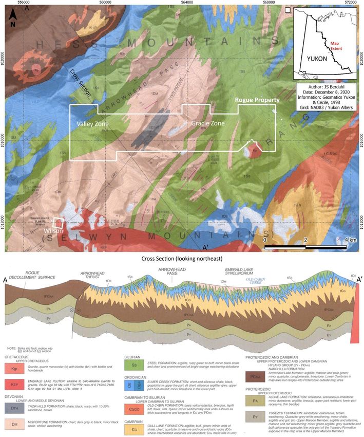
December 11, 2020

Table of Contents
1 - Summary ............................................................................................................................................ 4
2 - Introduction ....................................................................................................................................... 4
3 - Reliance on Other Experts ................................................................................................................. 5
4 - Property Description and Location .................................................................................................... 6
   4.1 Property Description ..................................................................................................................... 6
   4.2 Property Location.......................................................................................................................... 7
   4.3 Mineral Tenure ............................................................................................................................. 9
   4.4 Title ............................................................................................................................................... 9
   4.5 Royalties and Obligations.............................................................................................................. 9
       4.5.1 Private Royalties..................................................................................................................... 9
       4.5.2 Government Royalties ......................................................................................................... 10
   4.6 Environmental Liabilities ............................................................................................................. 10
   4.7 Permits ........................................................................................................................................ 10
   4.8 Land Use ...................................................................................................................................... 11
       4.8.1 First Nations ......................................................................................................................... 11
       4.8.2 Other Land Use .................................................................................................................... 12
       4.8.3 Other Significant Factors...................................................................................................... 12
5 - Accessibility, Climate, Local Resources, Infrastructure and Physiography ...................................... 13
   5.1 Topography, Elevation and Vegetation....................................................................................... 13
   5.2 Access .......................................................................................................................................... 13
   5.3 Proximity ..................................................................................................................................... 15
   5.4 Climate and Operating Season.................................................................................................... 15
6 - History .............................................................................................................................................. 15
   6.1 Prior Ownership .......................................................................................................................... 15
   6.2 Exploration History ..................................................................................................................... 16
       6.2.1 Rogue Area Regional Exploration......................................................................................... 16
       6.2.2 Valley-Gracie ........................................................................................................................ 17
       6.2.3 Old Cabin .............................................................................................................................. 18
       6.2.4 Wilson .................................................................................................................................. 19
       6.2.5 Ross ...................................................................................................................................... 19
       6.2.6 Christina ............................................................................................................................... 19
       6.2.7 Eastern Claims ...................................................................................................................... 19
   6.3 Historic Resources, Reserves and Production............................................................................. 20
7 - Geological Setting and Mineralization ............................................................................................. 20
   7.1 Regional Geology ........................................................................................................................ 20

 NI 43-101 Technical Report on the Rogue Gold Property, Yukon, Canada                                                           2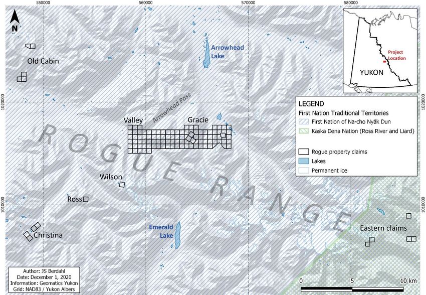
December 11, 2020

   7.2 Property Geology ........................................................................................................................ 22
       7.2.1 Valley-Gracie ........................................................................................................................ 22
       7.2.2 Old Cabin .............................................................................................................................. 22
       7.2.3 Wilson .................................................................................................................................. 22
       7.3.4 Ross ...................................................................................................................................... 22
       7.3.5 Christina ............................................................................................................................... 22
       7.3.6 Eastern Claims ...................................................................................................................... 22
   7.3 Mineralization ............................................................................................................................. 24
8 - Deposit Types................................................................................................................................... 27
   8.1 (Reduced) Intrusion Related Gold Systems................................................................................. 27
   8.2 Carlin-Style and Orogenic Gold ................................................................................................... 29
9 - Exploration ....................................................................................................................................... 29
10 - Drilling ............................................................................................................................................ 34
11 - Sample Preparation, Analyses and Security .................................................................................. 35
12 - Data Verification ............................................................................................................................ 36
13 - Mineral Processing and Metallurgical Testing ............................................................................... 38
14 - Mineral Resource Estimates .......................................................................................................... 38
15 - Adjacent Properties ....................................................................................................................... 39
   15.1 Reid & Vul Claims – Empire Metals Corp. ................................................................................. 39
   15.2 AU, ET & HER Claims – Luis Botto ............................................................................................. 40
   15.3 Jones Claims – Bartow Resources Inc. ...................................................................................... 41
16 - Other Relevant Data and Information ........................................................................................... 43
17 - Interpretation and Conclusions ..................................................................................................... 44
18 - Recommendations ......................................................................................................................... 45
   18.1 Overview ................................................................................................................................... 45
   18.2 Rogue Phase I, 2021 .................................................................................................................. 46
   18.3 Rogue Phase II - 2021 ................................................................................................................ 46
19 - References ..................................................................................................................................... 47
20 - Date and Signature Page................................................................................................................ 50
21 - Certificates of Qualified Persons.................................................................................................... 51

 NI 43-101 Technical Report on the Rogue Gold Property, Yukon, Canada                                                          3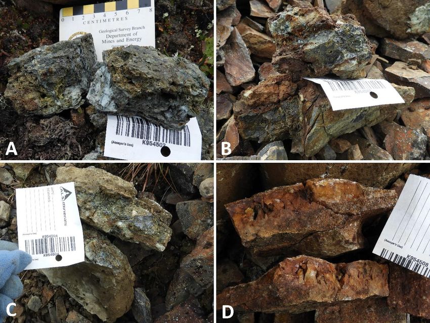
December 11, 2020
1 - Summary
The Rogue property is an early-stage gold exploration project in the Yukon Territory, Canada. The
property comprises 121 mineral claims covering roughly 2,440 hectares. 105 of these claims form a
single ten by two kilometre block, while the remaining claims cover small positions in five additional
areas. All claims will be 100% owned by Snowline Gold Corp. 1 pursuant to the completion of the
transaction set out in the purchase and sale agreement among Skyledger Tech Corp., 18526 Yukon
Inc. and Senoa Gold Corp. dated December 1, 2020.
Rogue targets multiple prospective intrusion-related gold systems (IRGS) associated with members
of the mid-Cretaceous Tombstone plutonic suite intruding heavily folded Paleozoic Selwyn Basin
sediments. Lower grade, bulk-tonnage targets are present as sheeted quartz veins within and
around the intrusions, complemented by higher grade vein and replacement style mineralization
that assays up to 152 grams per tonne gold in select grab samples. Within the IRGS family, a more
precise classification remains to be made, though at present multiple factors suggest a reduced
intrusion-related gold system (RIRGS) deposit model is applicable.
Regional reconnaissance exploration in 2011 with target-specific follow-up in 2011, 2012 and 2016
led to the identification of IRGS targets along a nine-kilometre hornfels trend, two of which (Valley
and Gracie) are on the large, primary claim block at Rogue. The targets have yet to see drill testing,
and significant work is needed before any mineral resource or mineral reserve estimates could
potentially be made.
On reviewing and visiting the project it is the authors’ shared opinion that Rogue has the potential to
host significant, economically viable gold resources. An aggressive two-phase, $3.4 million CDN
exploration program is recommended, including a $1.1 million phase one program to advance
existing targets, identify new targets, secure better claim positions and to test mineralization
through diamond drilling.
2 - Introduction
This report is prepared for Skyledger Tech Corp. (CSE: SKYL), a Vancouver-based, Canadian public
issuer listed on the Canadian Securities Exchange. The company has announced its intent to change
its name to Snowline Gold Corp. following acquisition of Rogue and other Yukon properties through
a purchase and sale agreement dated December 1, 2020. The Snowline name is used in this report.
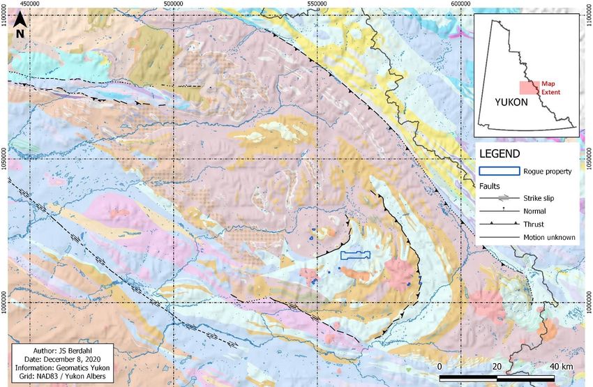
Rogue is an early-stage gold exploration project in the Yukon Territory (Figure 4.2), recently acquired
and 100% owned by Snowline Gold Corp. This report provides a summary of past mineral
exploration activities and resultant information on the Property along with recommendations for
future exploration. The purpose of the report is to inform the Exchange, potential investors and
1
At the time of writing, Snowline Gold Corp. is listed as Skyledger Tech Corp. This report is a part of a
fundamental change to the company’s operations from the technology sector into the mining sector, which
will include the renaming of the company to Snowline Gold Corp. For the purposes of this report, both names
refer to the same corporate entity.
NI 43-101 Technical Report on the Rogue Gold Property, Yukon, Canada 4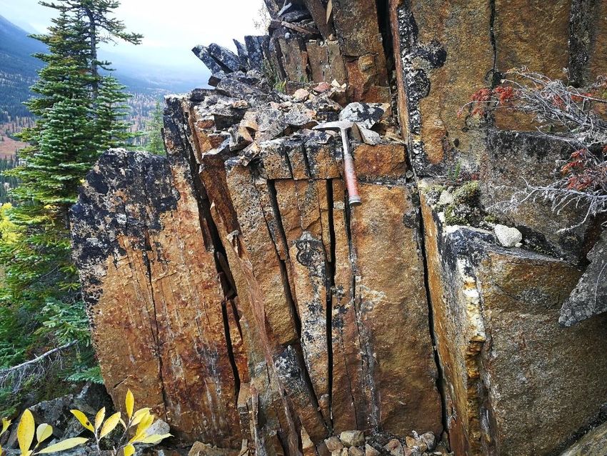
December 11, 2020

other interested parties as to the nature of the Rogue property in support of the company’s
fundamental change from a technology issuer to a mining issuer. The Rogue Property is a material
project to the company.

The report draws on a wide range of information but is prepared primarily based on the information
and data contained in annual summary reports on the Rogue property based on regional campaigns
during 2011 and 2012 (Lewis & Bennett, 2012 and Burke & Carlos, 2014 respectively). It also draws
on data from Snowline Gold Corp.’s Rogue property database, which was acquired from 18526
Yukon Inc. along with the project and captures work done on and around the project from 2008
through 2016, including data from the above programs. Additional references to sources of
information are made throughout the text, with details listed in Section 19.

The qualified persons have relied upon, and disclaim responsibility for, information derived from the
Yukon Government’s online “Mining Claims Database” (https://apps.gov.yk.ca/ymcs/). Further
mineral claim information, as well as information on First Nations traditional territories and on
hunting and trapping concessions was derived from the Yukon Government’s spatial information
branch Geomatics Yukon, through their file transfer protocol site (ftp://ftp.geomaticsyukon.ca/) and
online geospatial data viewer (https://mapservices.gov.yk.ca/GeoYukon/).

Both authors of this report have direct experience on the Rogue project. Linda Lewis worked as an
employee (part time) to former Rogue project optionee Golden Predator in 2011. That year, she
supervised and participated in the regional field program within and around the current property
limits and drafted the subsequent summary report (Lewis & Bennett, 2012). This included on-the-
ground sampling in the Gracie and Old Cabin areas of the current Rogue claims. Scott Berdahl, as a
contractor to 18526 Yukon Inc., took part in initial prospecting efforts in the Gracie area in 2008, and
he assisted in targeting and staking the roughly 5,000 claim property package optioned by 18526
Yukon Inc. to Golden Predator in 2010. He also conducted a small soil sampling and prospecting
program on and around the Rogue property claims in the Christina area on behalf of 18526 Yukon
Inc. in 2013. Both authors visited the Valley zone on September 7, 2020, to inspect and verify results
reported in Burke & Carlos (2014) for the purposes of this report.

3 - Reliance on Other Experts
The supervising author has not independently verified the legal status, ownership of the Property
area nor underlying property agreements.

 NI 43-101 Technical Report on the Rogue Gold Property, Yukon, Canada               5
December 11, 2020
4 - Property Description and Location
4.1 Property Description
The Rogue project covers 2,439 ha in 10 claim blocks comprising 121 quartz claims (Figure 4.1).
Most of these claims (105 of 121) are located in a single 2,098 ha claim block, with dimensions
roughly 10 km east to west and 2 km north to south, covering two primary target areas (Valley
and Gracie) along an east-west trend.
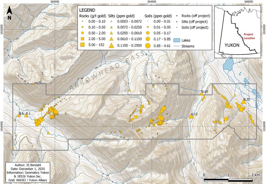
Figure 4.1 – Rogue property map showing the layout of individual claims and the names of various target areas.
NI 43-101 Technical Report on the Rogue Gold Property, Yukon, Canada 6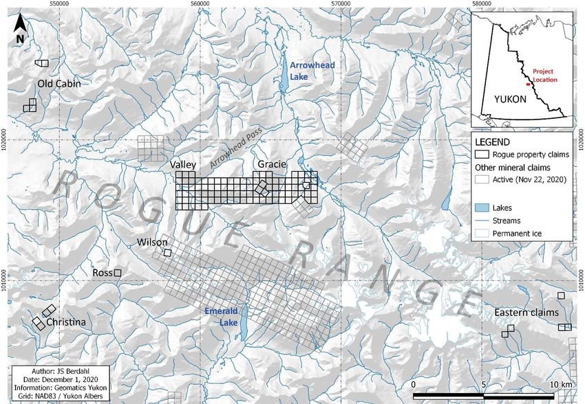
December 11, 2020

        4.2 Property Location

                                                          ROGUE

  Figure 4.2 – Location of Rogue relative to communities and infrastructure of the Yukon and surrounding jurisdictions.

Rogue property claims cover various targets throughout the Rogue Range of the Hess Mountains in
Canada’s Yukon Territory (Figures 4.1 & 4.2). The largest block is located immediately south of
Arrowhead Pass, roughly midway between Arrowhead and Emerald Lakes on NTS 1:50k
mapsheet 105O11, centred at 63° 37.8’ N, 131° 13.4’ W.

 NI 43-101 Technical Report on the Rogue Gold Property, Yukon, Canada                             7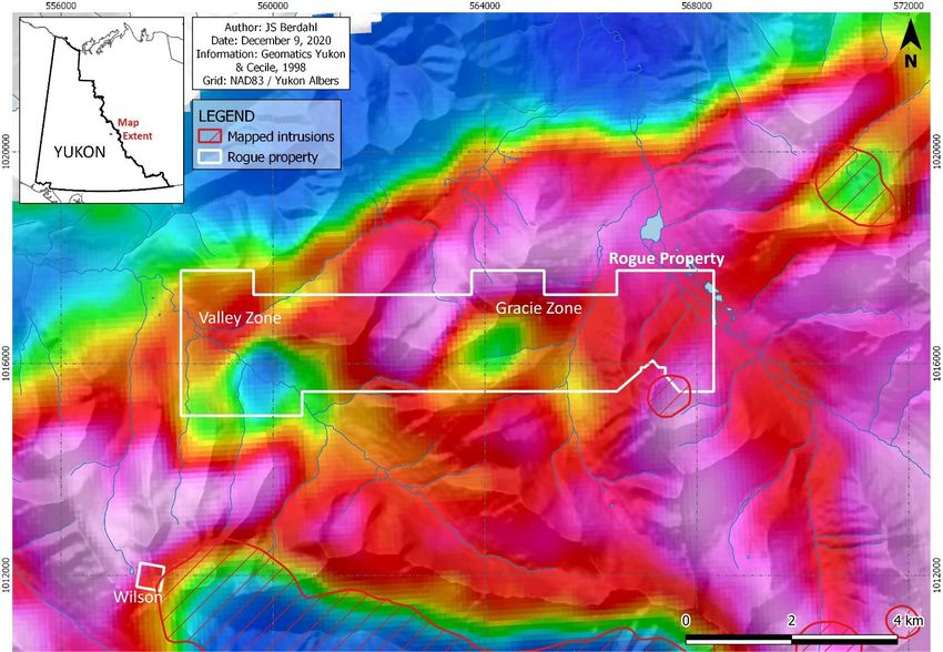
December 11, 2020

        Claim       Grant        Status         Expiry                     Claim         Grant       Status        Expiry
 1    Wilson 1    YC57747       Active        2021-10-19             62    AR 31       YE51095       Pending     2021-09-10
 2    AL 1        YC69941       Active        2021-10-19             63    AR 32       YE51096       Pending     2021-09-10
 3    AL 3        YC69943       Active        2021-10-19             64    AR 33       YE51097       Pending     2021-09-10
 4    JP 1        YC97571       Active        2021-10-19             65    AR 34       YE51098       Pending     2021-09-10
 5    JP 2        YC97572       Active        2021-10-19             66    AR 35       YE51099       Pending     2021-09-10
 6    JP 5        YC97575       Active        2021-10-19             67    AR 36       YE51100       Pending     2021-09-10
 7    JP 7        YC97577       Active        2021-10-19             68    AR 37       YC97641       Pending     2021-09-10
 8    RS 8        YC97594       Active        2021-10-19             69    AR 38       YC97642       Pending     2021-09-10
 9    AL 118      YC97604       Active        2021-10-19             70    AR 39       YC97643       Pending     2021-09-10
10    A 264       YD66153       Active        2021-10-19             71    AR 40       YC97644       Pending     2021-09-10
11    A 94        YD65984       Active        2021-10-19             72    AR 41       YD17339       Pending     2021-09-10
12    A 96        YD65986       Active        2021-10-19             73    AR 42       YD17340       Pending     2021-09-10
13    A 319       YD66208       Active        2021-10-19             74    AR 43       YD17341       Pending     2021-09-10
14    A 321       YD66210       Active        2021-10-19             75    AR 44       YD17342       Pending     2021-09-10
15    B 236       YD66573       Active        2021-10-19             76    AR 45       YD17343       Pending     2021-09-10
16    B 238       YD66575       Active        2021-10-19             77    AR 46       YD17344       Pending     2021-09-10
17    B 240       YD66577       Active        2021-10-19             78    AR 47       YD17291       Pending     2021-09-10
18    B 241       YD66578       Active        2021-10-19             79    AR 48       YD17292       Pending     2021-09-10
19    B 242       YD66579       Active        2021-10-19             80    AR 49       YD17293       Pending     2021-09-10
20    B 243       YD66580       Active        2021-10-19             81    AR 50       YD17294       Pending     2021-09-10
21    B 244       YD66581       Active        2021-10-19             82    AR 51       YD17295       Pending     2021-09-10
22    B 276       YD66611       Active        2021-10-19             83    AR 52       YD17296       Pending     2021-09-10
23    B 301       YD66636       Active        2021-10-19             84    AR 53       YD17297       Pending     2021-09-10
24    B 303       YD66638       Active        2021-10-19             85    AR 54       YD17298       Pending     2021-09-10
25    B 305       YD66640       Active        2021-10-19             86    AR 55       YD17299       Pending     2021-09-10
26    B 307       YD66642       Active        2021-10-19             87    AR 56       YD17300       Pending     2021-09-10
27    E 466       YD68422       Active        2021-10-19             88    AR 57       YD17257       Pending     2021-09-10
28    E 467       YD68423       Active        2021-10-19             89    AR 58       YD17258       Pending     2021-09-10
29    E 483       YD68439       Active        2022-10-19             90    AR 59       YD17259       Pending     2021-09-10
30    E 485       YD68441       Active        2022-10-19             91    AR 60       YD17260       Pending     2021-09-10
31    E 362       YD68318       Active        2021-10-19             92    AR 61       YD17261       Pending     2021-09-10
32    AR 1        YD79975       Pending       2021-09-10             93    AR 62       YD17262       Pending     2021-09-10
33    AR 2        YD79976       Pending       2021-09-10             94    AR 63       YD17263       Pending     2021-09-10
34    AR 3        YD79977       Pending       2021-09-10             95    AR 64       YD17264       Pending     2021-09-10
35    AR 4        YD79978       Pending       2021-09-10             96    AR 65       YD17265       Pending     2021-09-10
36    AR 5        YD79979       Pending       2021-09-10             97    AR 66       YD17266       Pending     2021-09-10
37    AR 6        YD79980       Pending       2021-09-10             98    AR 67       YD17267       Pending     2021-09-10
38    AR 7        YD79981       Pending       2021-09-10             99    AR 68       YD17268       Pending     2021-09-10
39    AR 8        YD79982       Pending       2021-09-10            100    AR 69       YD17269       Pending     2021-09-10
40    AR 9        YD79983       Pending       2021-09-10            101    AR 70       YD17270       Pending     2021-09-10
41    AR 10       YD79984       Pending       2021-09-10            102    AR 71       YD17271       Pending     2021-09-10
42    AR 11       YD79985       Pending       2021-09-10            103    AR 72       YD17272       Pending     2021-09-10
43    AR 12       YD79986       Pending       2021-09-10            104    AR 73       YD17273       Pending     2021-09-10
44    AR 13       YD79987       Pending       2021-09-10            105    AR 74       YD17274       Pending     2021-09-10
45    AR 14       YD79988       Pending       2021-09-10            106    AR 75       YD17275       Pending     2021-09-10
46    AR 15       YD79989       Pending       2021-09-10            107    AR 76       YD17276       Pending     2021-09-10
47    AR 16       YD79990       Pending       2021-09-10            108    AR 77       YD17277       Pending     2021-09-10
48    AR 17       YD79991       Pending       2021-09-10            109    AR 78       YD17278       Pending     2021-09-10
49    AR 18       YD79992       Pending       2021-09-10            110    AR 79       YD17279       Pending     2021-09-10
50    AR 19       YD79993       Pending       2021-09-10            111    AR 80       YD17280       Pending     2021-09-10
51    AR 20       YD79994       Pending       2021-09-10            112    AR 81       YD17281       Pending     2021-09-10
52    AR 21       YD79995       Pending       2021-09-10            113    AR 82       YD17282       Pending     2021-09-10
53    AR 22       YD79996       Pending       2021-09-10            114    AR 83       YD17283       Pending     2021-09-10
54    AR 23       YE51087       Pending       2021-09-10            115    AR 84       YD17284       Pending     2021-09-10
55    AR 24       YE51088       Pending       2021-09-10            116    AR 85       YD17285       Pending     2021-09-10
56    AR 25       YE51089       Pending       2021-09-10            117    AR 86       YD17286       Pending     2021-09-10
57    AR 26       YE51090       Pending       2021-09-10            118    AR 87       YD17287       Pending     2021-09-10
58    AR 27       YE51091       Pending       2021-09-10            119    AR 88       YD17288       Pending     2021-09-10
59    AR 28       YE51092       Pending       2021-09-10            120    AR 89       YD17289       Pending     2021-09-10
60    AR 29       YE51093       Pending       2021-09-10            121    AR 90       YD17290       Pending     2021-09-10
61    AR 30       YE51094       Pending       2021-09-10
 Table 4.3 – Rogue property claims. “Pending” status is applied by the Mayo Mining Recorder to claims recently staked, as is
 the case with the AR 1-90 claims. Expiration dates are shown in yyyy-mm-dd format.

     NI 43-101 Technical Report on the Rogue Gold Property, Yukon, Canada                           8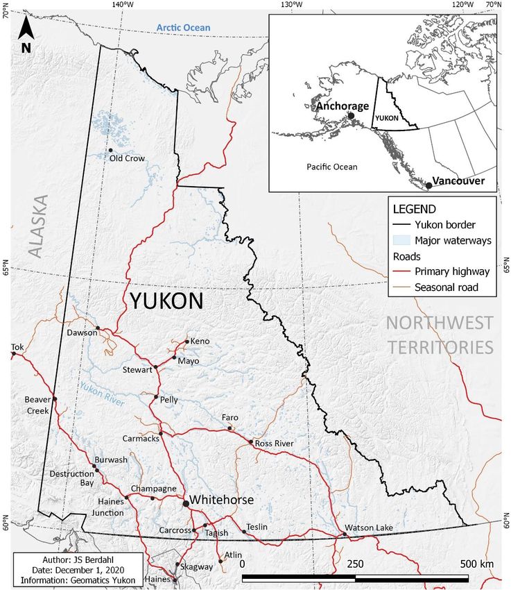
December 11, 2020

        4.3 Mineral Tenure
Rogue comprises 121 quartz claims as defined under the Yukon Territory’s Quartz Mining Act. Ninety
of these claims were staked in September 2020 and as such are listed by the Mayo Mining Recorder
as “Pending”. This is a normal claim status following recent claim staking, and the authors are aware
of no reason why these claims will not be upgraded to “Active” status in due time. Meanwhile, the
claims are functional mineral claims and can be explored accordingly.

A complete list of project claims precedes this section as Table 4.3.

        4.4 Title
Quartz claims as defined under the Yukon’s Quartz Mining Act grant the holder interest in
subsurface mineral rights for the ground they cover (up a maximum of 1,500 feet by 1,500 feet, or
20.9 ha, per claim). To maintain claims in good standing, exploration work must be performed on the
claims or on adjoining claims (maximum group size: 750 claims) at the value of $100/claim/year. If
such work is not performed, the claim holder may pay in lieu of work $100/claim/year directly to the
mining recorder to maintain the claims. In either case, a $5 filing fee is collected per claim-year
renewal applied to the property. Expiration dates for each claim as of September 2020 are listed in
Table 4.3.

Snowline Gold Corp. acquired 100% interest in the Rogue property from 18526 Yukon Inc.—a
private, Yukon-based company—in December 2020 through a purchase agreement, subject to
conditions discussed in Section 4.5.

        4.5 Royalties and Obligations
4.5.1 Private Royalties
Snowline Gold Corp.’s interest in the Rogue project is subject to a 2% NSR in favour of 18526 Yukon
Inc., 1% of which may be repurchased by Snowline at Snowline’s discretion in exchange for 1,000 oz
of gold bullion.

To maintain its interest in the Rogue project and other Yukon Territory mineral properties purchased
from 18526 Yukon Inc., Snowline must complete four annual cash payments of $250,000 CDN to
18526 Yukon Inc. on anniversaries one through four of the Closing Date for the December 1, 2020
purchase agreement.

Should a NI 43-101 compliant mineral resource exceeding 1,000,000 oz Au be defined in any
category on the Rogue project, Snowline will be obliged to make a cash bonus payment to 18526
Yukon Inc. of $1,000,000 CDN.

An area of interest exists around the claim block and is active for a period of four years. This AOI
extends for two kilometres around existing Rogue property claims and covers additional areas
identified by 18526 Yukon Inc. Claims staked or acquired by either party within this area, excluding
pre-existing third-party claims, become part of the property and are subject to the NSR and cash
bonus payments as outlined above.

 NI 43-101 Technical Report on the Rogue Gold Property, Yukon, Canada              9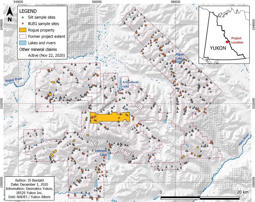
December 11, 2020

4.5.2 Government Royalties
Under section 102 of the Yukon Territory’s Quartz Mining Act, should any mineral claim in the Yukon
Territory achieve commercial production, an annual royalty becomes due to the Commissioner of
the Yukon on profits exceeding $10,000. The amount of the royalty is specified as follows:

                                   Annual Profit                     Royalty
                                >$10,000 and ≤$1M                      3%
                                  >$1M and ≤$5M                        5%
                                 >$5M and ≤$10M                        6%
                                      >10M                   Additional 1% for each
                                                             additional $5M interval
                          Table 4.5.2 – Government royalties due annually to the Commissioner
                          of the Yukon following commencement of commercial production.

           4.6 Environmental Liabilities
No existing environmental liabilities are known on the Rogue project.

           4.7 Permits
A Class 1 mineral exploration permit, covering early-stage exploration activities, is in place on all 31
Rogue project claims staked prior to September 7, 2020. The permit number is Q2020_0242, and it is
issued to 18526 Yukon Inc.

Notification of intended work on any claims not covered by this permit must be submitted to the
Yukon Government at least 25 days prior to commencement of that work, so that a Class 1 permit
covering those claims may be issued. For larger work programs exceeding ten individuals in camp at
any given time, more than 250 person-days total, or exceeding other thresholds2, a Class 2 or higher
permit will be required.

2
 A description of Class 1 activity thresholds can be found on the Yukon Government’s website at:
https://yukon.ca/en/doing-business/licensing/determine-class-your-quartz-mining-exploration-program#class-
1-exploration-program-limits

    NI 43-101 Technical Report on the Rogue Gold Property, Yukon, Canada                        10
December 11, 2020
4.8 Land Use
4.8.1 First Nations
The Rogue project lies entirely within the Traditional Territory of the Na-Cho Nyäk Dun First Nation,
as documented by the Yukon Government (Figure 4.8.1). The five quartz claims in three blocks
comprising the “East” targets also fall within the Traditional Territory of the Kaska Dena Nation
administered by the Ross River Dena Council. The Plata Winter Access Route, which might be
considered for use in any future development of the Rogue project, falls primarily within the
Traditional Territories of both the Na-Cho Nyäk Dun and the Kaska Dena First Nations.
The Traditional Territory of the Kaska Dena Nation is currently closed to mineral claim staking, and
thus the Eastern claims cannot currently be expanded, nor can new claims be staked in this area
until the ban is lifted.
Figure 4.8.1 – First Nations Traditional Territories in the Rogue property area. The entire project lies within the Traditional Territory of
the Na-Cho Nyäk Dun, while the Eastern claims lie within an overlap with the Traditional Territory of the Kaska Dena, which is currently
closed to mineral claim staking.
NI 43-101 Technical Report on the Rogue Gold Property, Yukon, Canada 11December 11, 2020
4.8.2 Other Land Use
Large hunting and trapping concessions cover most of the Yukon. The Rogue property overlaps two
outfitter’s concessions (concessions 7 & 9), and three trapping concessions (concessions 107, 109 &
110). Little activity is apparent in the vicinity of the project area outside of relatively light hunting
and trapping.
Figure 4.8.2 – Outfitting and trapping concessions in the Rogue property area. The most significant activity in either category is likely
seasonal hunting in the vicinity of Arrowhead Lake.
4.8.3 Other Significant Factors
No other significant factors nor risks are known that may affect access, title, or the right or ability to
perform work on the property.
NI 43-101 Technical Report on the Rogue Gold Property, Yukon, Canada 12December 11, 2020
5 - Accessibility, Climate, Local Resources, Infrastructure and
Physiography
5.1 Topography, Elevation and Vegetation
The Rogue project is characterized by the steep, rugged topography of the Rogue Range. Elevations
range from 1,140 m (3,740 ft) to 2,075 m (6,808 ft) within the main claim block and from 1,000 m
(3,281 ft) to 2515 m (8,251 ft) in the vicinity of the project area.
Vegetation ranges from minor, patchy spruce and fir forest in the valley bottoms to hillsides covered
in willow and dwarf birch, giving way to alpine mosses and grasses at moderate and higher
elevations. A large portion of the property has very little vegetative cover and is instead
characterized by talus and outcropping bedrock, with at least one rock glacier and several small
permanent snow and ice fields in north-facing cirques.
Figure 5.1 – Rogue property physiography as seen from a helicopter above Arrowhead pass. View looks southeast towards
the Gracie zone, which sits on the far side of the ridge that forms the central part of the horizon. Topography is steep, with
cliffy, impassable slopes on the highest ridges. A prominent rock glacier is visible in the central part of the photo.
5.2 Access
Access to most areas of the Rogue project is currently only feasible by helicopter. Nearby lakes
(Arrowhead and Emerald) and airstrips (Forks, Plata) allow for fixed-wing support and staging to
reduce exploration costs.
During the 1970s a winter access route was cleared from the North Canol Road to the Plata airstrip
to “walk” in heavy equipment for the Plata silver mine. Heavy equipment roads from the mine itself
come to within 21 km of Rogue project’s “Old Cabin” area claims and 30 km of the main Rogue claim
block, with low elevations and relatively gentle topography in between. This road has not been used
in decades and is partially overgrown, but with proper permitting and upgrades it could potentially
be used to support low cost exploration and development at Rogue in the future, if warranted.
NI 43-101 Technical Report on the Rogue Gold Property, Yukon, Canada 13December 11, 2020
Forks
Arrowhead
ROGUE
PLATA
Strategic Metals Plata Emerald
MACTUNG
NWT
Macmillan Pass
TOM/JASON
Fireweed Zinc
= Airstrip Location = Float-accessible Lake = Significant Mineral Deposit
Figure 5.2a – Rogue in relation to existing roads (North Canol), trails (Plata), airstrips and lakes accessible by large float plane.
Plata Airstrip
Winter Road
Figure 5.2b – September 7, 2020 aerial view of the Plata winter access route. Although the heavy equipment trail has not
seen documented use since the 1970s, the section observed by the author (Berdahl) does not appear to be heavily overgrown.
View looks NW, with Plata airstrip visible near the top right of the photo.
NI 43-101 Technical Report on the Rogue Gold Property, Yukon, Canada 14December 11, 2020
5.3 Proximity
The main claim block at Rogue is roughly 223 km east of the community of Mayo, 195 km north-
northeast of Ross River, 188 km northeast of Faro and 80 km northwest of the seasonal
exploration camp at Macmillan Pass, which also marks the nearest existing and functioning
road, the North Canol Road (Yukon Highway 6). The project is approximately 380 kilometres
from Whitehorse, the capital city of the Yukon Territory. Transport between the property and
any one of these settlements requires air travel.
5.4 Climate and Operating Season
The project area is subject to continental subarctic climate, with brief warm summers and long cold
winters. Daily high temperatures generally range from 15 to 25°C during the summer months and
extreme lows can drop below -45°C during the winter, though average winter lows may fall in the -
10 to -25°C range. Precipitation is generally light, but common, particularly during the summer.
The operational window varies from season to season, but generally runs for four months, from
regional melting in mid-late May to permanent snowfalls at lower elevations in mid-late September.
Activities like drilling and claim staking can be done later, though the shortened day length from
mid-October to mid-February decreases efficiency and thus increases cost. From October into early
May, avalanche risk is also a concern.
6 - History
6.1 Prior Ownership
The quartz claims comprising the current Rogue project were staked by 18526 Yukon Inc. in 2008,
2010 and 2020. The initial 2008 claim position was expanded by 18526 Yukon Inc. in 2010 to some
4,922 claims covering roughly 98,900 ha under an option agreement with Golden Predator Canada
Corp. This project, which was also called the “Rogue” project by Golden Predator, comprised six
blocks, “A” through “F”. Golden Predator dropped their option in 2013 as the company was
transitioned from a junior explorer to a royalty corporation (Americas Bullion Royalty Corp, now Till
Capital Corp). 18526 Yukon Inc. allowed many of the 4,922 claims to lapse and re-staked select
claims in 2020 following the upturn in gold prices and renewed interest in the district.
NI 43-101 Technical Report on the Rogue Gold Property, Yukon, Canada 15December 11, 2020
Figure 6.1 – Former Rogue property extent circa 2011, while under option to Golden Predator Canada Corp. Only select claims
were maintained by 18526 Yukon Inc., based on results from 2011 and 2012 fieldwork. Yellow stars denote Yukon Geological Survey
MINFILE locations, some of which are referenced in section 6.2.
6.2 Exploration History
6.2.1 Rogue Area Regional Exploration
The broader Emerald Lake plutonic complex has seen intermittent mineral exploration and
exploration data collection efforts going back as far as the 1950s. The histories of individual, third-
party properties in the vicinity of the Rogue project are discussed in section 15. The following
discussion touches only on those exploration efforts immediately relevant to current Snowline Gold
Corp. claim positions at Rogue.
The first geological mapping of the Rogue Range and the Emerald Lake plutonic complex was
conducted by Wheeler (1954), who outlined basic intrusive and sedimentary packages at a 1:253,000
scale. The most recent mapping on the project is that of Cecile (1998) at 1:50,000.
In 1967 and 1968, Atlas Explorations conducted regional mapping and geochemical sampling in the
Arrowhead Lake and Emerald Lake areas, though this work was focused on based metal
mineralization (e.g. Smith, 1967).
NI 43-101 Technical Report on the Rogue Gold Property, Yukon, Canada 16December 11, 2020 In 1968, regional aerial magnetic surveying conducted at approximately one-mile (1.6 km) line spacing covered the Rogue Range, revealing broad magnetic highs generally associated with hornfels around members of the Emerald Lake plutonic suite (Miles, 2017). In 1990, government funded regional silt sampling was collected through the Rogue Range and across large parts of the Selwyn Basin. Assays revealed a prominent, regional, multi-element geochemical anomaly in streams draining intrusions of the Emerald Lake plutonic complex and surrounding zones of hornfels, including anomalous gold (Héon, 2003). These samples were later reanalysed by the Yukon Geological Survey using updated laboratory procedures (Yukon Geological Survey, 2020). In 2008, Exploration Syndicate Inc. hired Geotech Inc. to fly a regional-scale ZTEM and magnetic survey over a 25,000 km2 area in the Selwyn basin at one-kilometre line spacing (Witherly, 2013). Coverage includes all Rogue claims apart from those in the Old Cabin area, highlighting magnetic anomalies related to hornfels throughout the Emerald Lake intrusive complex, and adding possible electromagnetic evidence of a buried intrusion at Gracie. In 2011, Golden Predator conducted a regional silt sampling program throughout the Rogue Range, and Newmont Mining conducted a bulk-leach-extractable gold (BLEG) silt sampling program across the area as well. These are discussed in more detail in section 9, and in Lewis & Bennett (2012). 6.2.2 Valley-Gracie Relevant Yukon Government MINFILEs for the main claim block at Rogue are “Arrowhead” (105O 012), though most of the summarized information describes the ET project some 4 kilometres to the northwest, and “LM” (105O 058), though the occurrence and most of the relevant results summarized are outside of the Rogue property boundary. In 1963, Dynasty Syndicate (or Dynasty Explorations) located a copper showing at the southwest end of Arrowhead Pass, just north of the Valley stock. This was followed up by Atlas Explorations in 1968, who reported four veins roughly one foot wide and 50 feet in length comprising 25% quartz and 75% sulphides, including arsenopyrite, bornite and chalcopyrite exposed in a creek canyon (Heinanen, 1968). No samples were analysed for gold or silver. In 1995 and 1996, Yukon Gold Corp. explored the Arrowhead stock just off the southeast edge of the main Rogue claim block through prospecting, mapping and diamond drilling (Lueck, 1996A & 1997). Some of this work occurred on the present-day Rogue claim block, possibly including parts of two drill holes (see section 10). This work located arsenopyrite bearing quartz veining in and around the stock grading to 6.7 g/t Au off claims (Lueck, 1996 – assay values within the current Rogue claim block not reported), and low-grade sheeted quartz veining observed in drilling both on and off the Rogue property, with two higher grade gold intervals encountered off the property. This work is discussed in more detail in section 15.1. Around this time, the SYB claims are noted by Jiang (1998) over the Gracie zone on the Rogue property. “Significant mineralization” is reported within hornfels, but no detail on the project nor the work program are given. In 2008, 18526 Yukon Inc. staked the initial claims of the current claim block and performed a reconnaissance sampling program in the Gracie zone, collecting 28 rock samples and 7 silt samples. Rock samples ran up to 4.3 g/t Au, with a high bismuth component thought to come from an NI 43-101 Technical Report on the Rogue Gold Property, Yukon, Canada 17
December 11, 2020

intrusive source. Silt sampling extended the prospective area to the northwest (Berdahl, 2009). Co-
author of this report Scott Berdahl was involved in the 2008 field program.

In 2011, Golden Predator’s regional stream sediment sampling program returned anomalous gold
and arsenic in silt samples across multiple drainages draining the Valley-Gracie trend. Rock sampling
at Gracie revealed gold and copper bearing polymetallic replacement of Earn Group sediments, as
well as arsenopyrite-quartz veins, breccias and replacements assaying up to 57.0 g/t gold (Lewis &
Bennett, 2012). Supervising author on this report Linda Lewis was involved with the 2011 field
program.

In 2012, Golden Predator followed up with prospecting traverses in both the Gracie and Valley
zones. This work identified the existence of the Valley stock and gold-bearing, sheeted quartz veining
within it, with individual veins assaying up to 10.1 g/t Au. Grab sampling of arsenopyrite-rich
sulphide vein float immediately north of the stock assayed as high as 152.0 g/t gold, and channel
sampling of hornfels outcrops exposed along Old Cabin Creek west of the stock returned 4.2 g/t gold
over 4.7 metres (Burke & Carlos, 2014). A channel sample at the presumed site of the 1963 copper
showing averaged 0.65 g/t Au, 1.3% Cu and 65 g/t Ag over 12 metres, though these results have not
been directly verified and it is unclear how this sample length relates to the orientation of
mineralization.

In 2016, 18526 Yukon Inc. performed a small soil sampling and prospecting program in the Valley
zone for assessment credits. A soil line along the northern margin of the Valley stock revealed
previously unknown zones of anomalous gold, with values of up to 4.6 g/t gold in soils (Mann, 2016).

On September 7, 2020, the authors of this report visited the Valley zone to verify past results. The
zone of high-grade sulphide veins was visited, as was the nearby zone of sheeted veining. Overall
grades were confirmed by sampling, as was the presence of gold-bearing sheeted veining, though
significant additional work remains to be done to assess whether economically viable mineralization
is present on the property.

6.2.3 Old Cabin
While the Old Cabin area has seen historic work, as documented in the Yukon Government’s “Horn”
(105O 010) and “Old Cabin” (105O 039) MINFILE reports, very little of this work occurred within the
small claim position that belongs to the current Rogue property.

Off-claim work includes mapping and sampling for copper exploration by Canadian Oil and Gas Ltd.
in 1970 (Marshall, 1971), mapping, sampling and aerial magnetics for gold exploration by the Union
Carbide Exploration Corporation in 1981 and 1982 (James, 1982A & 1982B), and additional mapping
and sampling for gold exploration was performed by the Eagle Plains/Miner River joint venture in
1996 and 1998 (Dickie, 1997A; Kreft, 1998). Golden Predator silt sampled and prospected in the area
in 2011, and 18526 performed a small soil sampling program on and around the current Rogue
property claim position at Old Cabin in 2016. This work identified at least six zones of gold
mineralization, with rock samples up to a maximum of 20.4 g/t gold (James, 1982A). Note that off-
claim mineralization is not necessarily indicative of similar grades on the claim blocks.

Sampling within the current property position is limited, on the northern block, to nine rock samples,
with a specimen from a northeast trending, northwest dipping quartz arsenopyrite vein system on
the claims assaying 8.67 g/t Au (Bennet, 2011A) and skarn material 380 metres to the southwest
assaying to 5.27 g/t Au (Lewis & Bennett, 2012). On and draining the southern claim block, highly
anomalous gold concentrations in silts have independently been sampled and reported by the Yukon
Geological survey (Héon, 2003), Golden Predator (Lewis & Bennett, 2012) and 18526 Yukon Inc.

 NI 43-101 Technical Report on the Rogue Gold Property, Yukon, Canada             18
December 11, 2020

(Mann, 2016). A soil line by 18526 Yukon Inc crossed the southern claim block and returned a lone
anomalous value of 358 ppb Au (Mann, 2016).

None of the above samples, apart from those reported in Lewis & Bennett (2012), have been verified
by the authors.

6.2.4 Wilson
The Wilson claim covers part of the “Mt. Soleil” zone, which was explored through mapping,
sampling and trenching by AGIP Canada Ltd. in 1981 and 1982 (Robertson, 1981; Garagan, 1983),
and again by APC Ventures Ltd. in 1995 (Irwin, 1996). Sampling conducted by professional climbers
in 1996 returned 2.2 g/t Au across 8.5 metres, with select grab samples to 7.7 g/t Au (ibid.). These
results have not been verified by the authors of this report. Additionally, given the uncertainty in the
exact position of this sampling to the claim, it cannot be stated with certainty that the samples fall
within the current Wilson claim boundary on the Rogue property.

Both the AGIP and the APC programs formed parts of larger campaigns directed at exploring the
Emerald Lake pluton, documented in more detail in see section 15.3, and in Yukon Government’s
“Emerald” MINFILE (105O 009).

6.2.5 Ross
The Ross claim and surroundings were explored in the 1990s by Ebert (1991), assessing for porphyry
potential, and by Dickie (1997B), looking for “Fort Knox style” or reduced intrusion-related gold.
Ebert reported grades of up to 36 g/t Au in narrow (15 centimetre), parallel quartz veins. A contour
soil line collected across the claim in 2012 by 18526 Yukon Inc. returned elevated to anomalous gold
values (18526 Yukon Inc. private database). The claim sits proximal to the Yukon Government’s
“Scronk” MINFILE (105O 059).

Apart from the soils by 18526 Yukon Inc., these results have not been verified by the authors of the
report. Additionally, given the uncertainties in exact sample position on historic paper maps, it is
possible that the historic mineralized rock samples were taken off the current claim, in which case it
would not necessarily be indicative of mineralization on the current claim.

6.2.6 Christina
The Wilson claims and surroundings were also explored in the 1990s by Ebert (1991), assessing for
porphyry potential, and by Dickie (1997B), looking for “Fort Knox style” or reduced intrusion-related
gold. Ebert reported discrete zones of sheeted quartz veining assaying to 14 g/t Au, and a 1.5 m chip
sample from a zone of tourmaline-arsenopyrite breccia reported by Dickie assayed 4.6 g/t Au. A grab
sample of this breccia collected in 2012 by author Berdahl returned 4.4 g/t Au, and a soil line
collected by 18526 Yukon Inc. samplers returned elevated to anomalous gold value in soils on and
around the claims (18526 Yukon Inc. private database). The claims cover parts of the area described
in the Yukon Government’s “Christina” MINFILE (105O 055).

The 14 g/t Au sample has not been verified by the authors.

6.2.7 Eastern Claims
Silt sampling in 2011 identified a 700 ppb Au stream sediment anomaly (Lewis & Bennett, 2012)
downstream of the Elmer Creek thrust fault. Limited rock and soil sampling in the vicinity of the
claims by Golden Predator failed to explain the anomaly (Burke & Carlos, 2014).

 NI 43-101 Technical Report on the Rogue Gold Property, Yukon, Canada               19
December 11, 2020

          6.3 Historic Resources, Reserves and Production
No historic mineral resources nor mineral reserves, NI 43-101 compliant or otherwise, have been
defined in the Rogue project area, and no production has occurred from the claims.

7 - Geological Setting and Mineralization
          7.1 Regional Geology

Figure 7.1a (from Colpron, 2007) – Terranes of the Canadian-Alaskan Cordillera. The Rogue property is located just east of
the “Selwyn basin” label in the east-central Yukon Territory. The dark blue units of this terrane were deposited in place as
shallow to deep water marine rocks alongside the ancestral North American continental platform (light blue). In contrast,
most other terranes in this figure formed elsewhere and were later moved into their current position by plate tectonics. The
collisional forces of this terrane accumulation led to deformation and light metamorphism of the Selwyn basin and ancestral
North America near the collisions, out to the line marked as the “eastern limit of Cordilleran deformation.”

 NI 43-101 Technical Report on the Rogue Gold Property, Yukon, Canada                               20
December 11, 2020
The Rogue project is located in the Selwyn Basin, a thick sequence of Neoproterozoic to Paleozoic
sedimentary rocks accumulated on the passive ancestral margin of North America. The basin now
sits inboard of the Tintina fault, which truncates it along its southwest margin and has transported
similar units west into central Alaska (Figure 7.1a). Units include thick sequences of only lightly
metamorphosed mudstones, siltstones and quartz-rich sandstones, interbedded with regionally
extensive carbonate formations and rare carbonate debris flow, along with volcaniclastic units.
Following sedimentation, regional compression variably shortened units of the Selwyn Basin through
extensive faulting and folding. In the project area, stratigraphy is tightly folded by the Emerald Lake
synclinorium (Cecile, 2000). This pattern of tight folding was itself folded on a regional scale
sometime following the late Triassic, into a large drag fold feature along the right-lateral Hess-
Macmillan fault system (ibid.), as seen in Figure 7.1b. Light regional prehnite-pumpellyite
metamorphism throughout the local region of the Selwyn Basin likely formed during this time.
Multiple intrusive bodies belonging to the Tombstone Plutonic Suite penetrated local stratigraphy in
and near the apex of this regional drag fold during the Cretaceous. These intrusives range from
syenite to granodiorite in composition (e.g. Duncan, 1999), though most are classified as granites
(Cecile, 1989). Several large, polyphase plutons to 10 kilometres in diameter are accompanied by
smaller stocks with surface exposures less than a kilometre. Conspicuous zones of contact
metamorphism surround most intrusions.
Arrowhead
Thrust
Elmer
Creek
Thrust
Figure 7.1b – Geological setting of the Rogue project, highlighting major structural features at a regional scale. The project is situated within
a tectonostratigraphic block bound on the northeast by the Selwyn Valley thrust and on the southwest by the dextral Hess-Macmillan fault
system. Tight, NW-SE trending fold axes near the Selwyn Valley thrust are wrapped in a broad drag fold (syncline) by motion along the Hess-
Macmillan fault, as are the associated Arrowhead and Elmer Creek thrusts. At the apex of this fold, the sedimentary package is intruded by
Cretaceous (red) members of the Tombstone plutonic suite.
NI 43-101 Technical Report on the Rogue Gold Property, Yukon, Canada 21December 11, 2020
7.2 Property Geology
7.2.1 Valley-Gracie
The main block of the Rogue project covers Silurian to Devonian shales, cherts, sandstones and
minor carbonates of the Steel and Portrait Lake formations (Figure 7.2.1). This stratigraphy is cut by
tight, overturned folding of the Emerald Lake synclinorium with steeply southeast dipping axial
planes (Cecile, 1998). Two small granitic intrusions outcrop on the property, the Arrowhead stock on
its southeast margin, and the newly identified Valley stock (Burke & Carlos, 2014) on the west end of
the property. A third, unexposed intrusion is inferred beneath the Gracie zone based geophysical
data and the intensity of hornfels alteration with no obvious source. Owing to these intrusions,
much of the claim block is moderately to strongly hornfelsed along an east-west trend roughly
paralleling the claim block itself.
7.2.2 Old Cabin
The claims in the Old Cabin area are underlain by siliciclastics and volcanics of the Neoproterozoic to
Cambrian Narchilla and Gull Lake formations. While no intrusion is present on surface, hornfelsing
and skarn near the claim block, as well as an associated magnetic anomaly, suggest the presence of a
covered intrusive body in the vicinity.
7.2.3 Wilson
The Wilson claim covers a zone of hornfelsed argillites of the Devonian Portrait Lake formation on
the western edge of the Cretaceous Emerald Lake pluton, cut locally by a quartz monzonite dike,
with quartz-tourmaline veining present (Garagan, 1983).
7.3.4 Ross
The single Ross claim covers an area of tightly folded, north dipping argillites and cherts of the Steel
formation, within the hornfelsed aureole of a roughly 700 metre diameter granitic stock exposed to
the northwest of the claim. Ebert (1991) reported abundant quartz veining in this area.
7.3.5 Christina
The Christina claims overlie the southeast margin of the mid-Cretaceous “Fango” or “Rogue West”
pluton where it contacts Devonian siliciclastic units and minor volcanics assigned to the Earn Group.
Localized trends of sheeted quartz-tourmaline veining are present in the intrusion, and a localized
zone of tourmaline-matrix breccia is present some 500 metres from the intrusive contact (Ebert,
1991).
7.3.6 Eastern Claims
The five scattered eastern claims sit at and adjacent to the eastern edge of the Cretaceous, granitic
Rogue Pluton, where the arcuate Elmer Creek thrust places clastic units of the Cambrian Gull Lake
formation over Devonian Road River group clastics (Cecile, 1996).
NI 43-101 Technical Report on the Rogue Gold Property, Yukon, Canada 22December 11, 2020
Valley stock
Arrowhead
stock
Emerald Lake pluton
Figure 7.2.1 (modified from Cecile, 1998) – Rogue property geology. Cecile’s 1998 map of the Arrowhead Lake area is the latest and most detailed
geological map of the Rogue property and its surroundings. The main claim block sits parallel to and several kilometers north of the Cretaceous Emerald
Lake pluton, in a region of mostly fine clastic Paleozoic sediments heavily shortened above the Rogue decollement surface (Cecile, 2000) within the
Emerald Lake synclinorium. This structural preparation predates magmatism and may provide abundant loci for mineralization. The Valley stock was
not observed by Cecile, and intense hornfels suggests another stock is present below surface at the Gracie zone. Note that Cecile’s Thor Hills and
Misfortune formations are elsewhere classified as Portrait Lake formation.
NI 43-101 Technical Report on the Rogue Gold Property, Yukon, Canada 23December 11, 2020
7.3 Mineralization
Various styles of gold mineralization have been recognized on the Rogue property, all of which are
consistent with an intrusion-related gold system model and are very likely attributable to fluids
related to the emplacement of intrusions of the Emerald Lake plutonic suite. The most prominent
include:
1. Sheeted quartz veining. Relatively sulphide-poor, white to rusty quartz veins running
parallel to jointing both within and proximal to intrusives. (A sample taken by the author
from the northwest trending vein shown above returned 5.68 g/t Au, and while joints were
closely spaced actual quartz vein density appeared low at the site examined.) Such veining
has been observed in the Valley stock and the Arrowhead stock (mostly or completely off-
claims, Lueck 1997). In the Wilson (Garagan, 1983), Ross and Christina (Ebert, 1991) claim
blocks, similar veining has been observed with a significant tourmaline component.
NI 43-101 Technical Report on the Rogue Gold Property, Yukon, Canada 24December 11, 2020
2. Polymetallic quartz/sulphide veins. Gold-bearing veins often dominated by sulphides,
particularly arsenopyrite, with iron, silver, lead, bismuth and tellurium associations and
varying amounts of copper. Observed in the Valley zone (Burke & Carlos, 2014, Heinanen,
1968), with grades of up to 152 g/t Au (44.8 g/t Au in sample shown), the Gracie Zone
(Bennett, 2011B) on the Old Cabin claims (Bennett, 2011A), and on or near the Ross claim
(Ebert, 1991).
3. Disseminated sulphides (photo from Burke & Carlos, 2014). Disseminated sulphides and
fine quartz veining replacing calcareous sediments and surrounding fault zones bearing
mineralization of type 2 described above. Observed in the Valley zone (Burke & Carlos,
2014).
NI 43-101 Technical Report on the Rogue Gold Property, Yukon, Canada 25December 11, 2020
4. Skarns (photo from Bennett, 2011A). Pyrrhotite-rich, gold and copper bearing massive
sulphide replacement of calcareous sediments, observed at Old Cabin (Lewis & Bennett,
2012).
NI 43-101 Technical Report on the Rogue Gold Property, Yukon, Canada 26December 11, 2020
8 - Deposit Types
8.1 (Reduced) Intrusion Related Gold Systems
Rogue
Figure 8.1a (modified from Hart, 2007) – The Tintina Gold Province hosts a suite of reduced intrusion-related gold
occurrences (shown as red circles; other gold deposits are shown as black circles, and tungsten deposits are shown in purple)
across the Yukon and Alaska, particularly around members of the Tombstone Plutonic Suite (the extent of which is highlighted
in pink). Members of the Emerald Lake plutonic suite underlying Rogue sit near the east end of the Tombstone Plutonic Suite.
F=Fairbanks, Alaska; D = Dawson, Yukon; M = Mayo, Yukon; W = Whitehorse, Yukon.
Reduced intrusion related-gold systems (RIRGS) are characterised by widespread, sheeted, gold-
bearing veins within and around small (100 metre to 5 kilometre diameter) intrusive bodies,
particularly in and near their upper carapaces (Hart, 2007). They generally form low-grade, bulk
tonnage orebodies, with spacing between sheeted veins governing grade, though higher-grade
veins, replacements and skarns can complement mineralization and increase overall grade. As
suggested by the name, reduced intrusion-related deposits form around reduced, ilmenite series
(versus oxidized, magnetite series, see Ishihara, 1977) intrusions that have interacted with carbon-
bearing metamorphic and sedimentary rocks during their development. Iron occurs primarily in non
to weakly magnetic minerals, and thus the intrusions themselves do not stand out in magnetic
surveying. Contact metamorphism of surrounding rock caused by the plutons, however, often
produces pyrrhotite, a magnetic iron sulphide, and thus the zones around and above a reduced
intrusion can stand out in magnetic surveying. Geochemically, gold in these systems is often
correlated with the elements bismuth and tellurium, and causative plutons may also form large
tungsten deposits (Hart, 2007). Mineralization is often zoned, with intrusion-proximal mineralization
as above giving way to arsenic and farther antimony bearing gold mineralization, and farther still,
silver-lead-zinc veins (Figure 8.1b).
NI 43-101 Technical Report on the Rogue Gold Property, Yukon, Canada 27You can also read