Runaway Dinosaur Tracks: Cooperative Efforts to Preserve Fossil Resources at Two National Natural Landmark Sites
←
→
Page content transcription
If your browser does not render page correctly, please read the page content below
Runaway Dinosaur Tracks: Cooperative Efforts to Preserve Fossil
Resources at Two National Natural Landmark Sites

Heather Germaine, Intermountain Regional National Natural Landmarks Coordinator,
    National Park Service, 12795 W Alameda Parkway, Denver, CO 80225; heather_ger-
    maine@nps.gov
Joe Tempel, Executive Director, Friends of Dinosaur Ridge, 16831 W. Alameda Parkway,
    Morrison, CO 80465; joe_tempel@dinoridge.org
Mike O’Brien, Exhibits Specialist, Texas Parks and Wildlife Department, 4200 Smith
    School Road, Austin, TX 78744; mike.obrien@tpwd.state.tx.us

Long-term preservation of fossil resources has unique challenges, given that the natural
preservation state for these resources is to be buried. Intentional or non-intentional excava-
tion are the means by which we are made aware of paleontological resources. Once exposed,
they become available for scientific discovery, study, and interpretation; however, they also
become susceptible to weathering, erosion, and collection. Thus landowners of lands con-
taining fossil resources, who are either charged with conservation by law, policy or organiza-
tional mission, or voluntarily elect to conserve fossil resources, face a variety of challenges
and key decision points. This paper explores the methods undertaken and partnerships
employed for long-term preservation of dinosaur track resources at two National Natural
Landmark (NNL) sites. The Morrison Fossil Area in Colorado and Dinosaur Valley in Texas
are designated NNL sites in recognition of their significant paleontological resources and
both are actively addressing the issues associated with long-term preservation of such her-
itage resources.
      The National Natural Landmarks Program was established by the Secretary of the In-
terior in 1962, under authority of the Historic Sites Act. Administered by the National Park
Service (NPS), the primary program objectives are to identify, recognize and encourage the
preservation of sites containing the best remaining examples of biological and geological fea-
tures that illustrate our nation’s natural heritage. With designation occurring on lands of any
ownership, the NNL Program is the only natural areas program of national scope that recog-
nizes outstanding examples of biological and geological features in both public and private
ownership. To date, 586 sites in 48 states, 3 territories, and the Commonwealth of Puerto
Rico have been designated as NNLs.
      Landmark designation is not a land withdrawal, does not change ownership of the site,
does not require public access, and does not dictate use nor impose any land use activities.
It is a recognition program highlighting and raising public awareness of significant natural
resources. Landmark designation also creates a partnership between the National Park Ser-
vice and the landowner, such that the NPS can be an advocate for and assist in the conserva-
tion of significant natural resources.
      Based on NNL significance criteria of illustrative character, present condition, rarity,
diversity and value for science and education, NNL resources are considered to be some of
the best examples of those biological or geological features within a bio-physiographic
province. Potential NNL sites go through an in-depth evaluation by a qualified scientist(s) to
324 • Protected Areas in a Changing World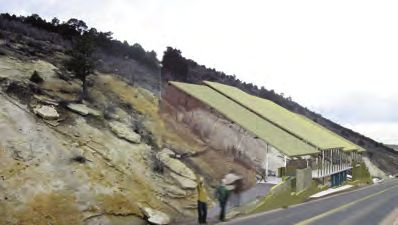
Managing Paleontological Resources
determine the fit of the potential site as it relates to these national significance criteria and in
comparison to other sites with similar resources. Evaluation reports go through internal and
external review and designation is ultimately conferred by the Secretary of the Interior, with
owner consent. More information on the NNL Program can be found at www.nature.-
nps.gov/nnl.
The Morrison Fossil Area (locally known as Dinosaur Ridge, see www.dinoridge.org),
located approximately 35 miles west of Denver, Colorado, was designated a NNL in 1973.
The site is significant as the site of the first major discovery of giant dinosaur fossil bones in
North America. In the late 1800’s, fossils from nine different species of dinosaur were recov-
ered, seven of which were newly discovered species. The site also contains a dinosaur track-
way with over 300 dinosaur tracks that were made by three types of dinosaurs and one croc-
odile.
The tracksite is located in the South Platte Formation, which is composed primarily of
thin to massive sandstone units with thin shale interbeds, and has a slope of 37–38 degrees
(77%). The site is also open and exposed to the outdoors and thus is susceptible to weath-
ering (Figure 1).
Natural erosional processes have taken a toll on the tracksite over the years resulting in
the loss of tracks. This has typically occurred in the form of small rocks slides. The interbed-
ded shale begins to crumble after being compromised by water seepage and freeze-thaw
cycles. This in turn results in the overlying track-bearing sandstone layer breaking up, and
sliding down the face of the tracksite.
In April 2006, a sandstone slab containing several tracks sloughed off the main trackway
and slid to the bottom of the hill. As previously discussed, this has been the natural progres-
sion of erosion at the site. Piecemeal solutions, including wire-mesh and shotcrete, a concrete
diversion structure, rebar pins and metal strapping, have been implemented over the years in
an attempt to arrest the erosion. However, these are typically short-term, band-aid repairs,
versus substantial protection measures.
The Friends of Dinosaur Ridge (FODR), the non-profit managing entity at the site, was
founded in 1989 to preserve the fossils on the ridge and to educate the public. Approxi-
mately 100,000 visitors, including 10,000 school children visit the site each year. In addition
to its national significance
and scientific value, the
site’s proximity to a large
metropolitan area and
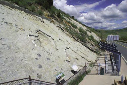
Figure 1. Main tracksite at
Morrison Fossil Area National
Natural Landmark (Dinosaur
Ridge) in Lakewood, Colora-
do. Dinosaur tracks located in
sandstone along the Dakota
Hogback, tilted at a 37–38
degree slope. Photo by S.
Hutchison.
Proceedings of the 2009 George Wright Society Conference • 325Managing Paleontological Resources
easy access to viewing such dramatic evidence of life from millions of years ago, makes this
site a favorite among locals. Given the site’s significance, the mission of the FODR, and the
continued loss of the resource from erosion, investigations into longer-term preservation
options became imperative.
Using the partnership in place through the NNL designation, the expertise of two Na-
tional Park Service Geologists were employed to provide an overall assessment of the condi-
tion of the tracksite and to offer short- and long-term management recommendations. They
determined that if no action was taken, more tracks would continue to be lost and that over
time, perhaps over several decades to a century, the entire tracksite is in jeopardy of being lost
completely to a progression of slides. The FODR have also sought consultation and input
from the State Historical Society, paleontologists, architects, and engineers, and have since
determined that a structure over the tracksite is the alternative that would best provide for
the long-term preservation of the track resources, thereby ensuring its continued presence
for future generations.
The past couple of years have been spent designing a structure for the tracksite that will
meet long-term resource preservation needs, provide viewing and educational opportunities,
as well as meet aesthetic requirements. Situated on the side of a wide valley, the main track-
site at the Morrison Fossil Area can be seen for quite some distance. Thus in addition to the
challenges associated with the steep setting of the tracksite, the view of Dinosaur Ridge has
also been an important consideration in the structure’s design. After much research, many
versions, and passionate discussion, final renderings have recently been completed (Figure
2).
The proposed structure, which will include a solid foundation wall and perimeter drain
at the top to divert water away, will protect the tracksite from the erosional effects of freeze-
thaw cycles. Additionally, it will include a translucent roof to produce the flat natural light-
ing for best viewing, new interpretive exhibits on the second floor, and elevated walkways up
either side of the trackway to provide for more public educational opportunities and new
ways to view and experience the resources. A major fundraising campaign has recently been
undertaken to help raise the money needed for construction (tracksite cover, $2 million dol-
lars; a child in awe over dinosaur tracks for generations to come, priceless).
The second NNL site experiencing runaway dinosaur tracks is Dinosaur Valley. This
NNL is located within Dinosaur Valley
State Park just outside Glen Rose in the Figure 2. Computer generated rendering of pro-
central hills of Texas (see www.tpwd.- posed tracksite cover for main tracksite at Morrison
Fossil Area National Natural Landmark.
state.tx.us/spdest/findadest/parks/
dinosaur_valley). Dinosaur Valley was
designated a National Natural Land-
mark in 1968 in recognition of the
series of trackways that contain some of
the best preserved Sauropod and Ther-
opod footprints. The site contains the
first discovered and identified Sauro-
pod trackways, and they are designated
326 • Protected Areas in a Changing WorldManaging Paleontological Resources
as the type specimen for that species. Additionally, one of the park’s Theropod tracks was
designated as the type specimen for Acrocanthosaurus. The tracks also provide evidence
related to the herding, habits and locomotion methods of Sauropods and their interaction
with Theropod carnosaurs. The Theropod tracks are a good source of information regard-
ing the maximum speed of bipedal Theropods.
The dinosaur tracks at Dinosaur Valley are preserved primarily in limestone within the
bed of the Paluxy River and tributary creeks (Figure 3). Therefore, as with the fossil re-
sources at Morrison Fossil Area, the track resources at Dinosaur
Valley are also susceptible to the natural effects of weathering.
However, given the extent of the resources and their riverine loca-
tion, building a structure to cover the track sites is not a viable
management action; continued erosion and loss of tracks at this
site are inevitable. Therefore, an important aspect of managing and
preserving these important resources is having a thorough inven-
tory of the track resources and ideally having those data digitally
stored for easy retrieval and long-term, archival storage.
It was estimated that about 80% of the known track sites have
Figure 3. Theropod been mapped at the park. The first maps were made in the late
tracks preserved in the 1930’s and mapping continued through the 1990’s. However,
limestone bed of the Pal- these maps were recorded on paper using measuring tape, triangu-
uxy River at Dinosaur Val-
ley National Natural lation and a compass. These maps have not been gathered into a
Landmark, which is locat- single geo-referenced map using modern GIS technology, thus the
ed within Dinosaur Valley risk remains that the maps, which represent the park’s primary
State Park, near Glen documentation, are subject to loss. Additionally, as most of the
Rose, Texas. Photo by M.
O’Brien. tracks are located within the bed of the river, many of the tracks
documented over the past 70 years are gone or are disappearing
due to natural streambed erosion. Thus, there was a critical need for complete and digital
documentation of the park’s track resources.
The NNL status at the site made it eligible for funding through the NPS Challenge Cost
Share Program (CCSP). CCSP funding was applied for to help address this need, and fund-
ing was awarded for 2008–2009. Project partners include the National Park Service, Texas
Parks and Wildlife Department, Indiana-Purdue University, a volunteer paleontologist who
has been involved with mapping at the park for the past 28 years, and the Friends of Dino-
saur Valley. The overall goal for the project was to bring together the work of the past 70
years of track documentation into a long-term, geo-referenced digital format using GIS, to
make the data accessible for future study and to guide in management decisions and preser-
vation efforts, and to create a fully interactive map of the park’s track sites to serve as an edu-
cational resource for park visitors.
A major effort to collect data took place during the summer and fall of 2008. Data were
collected at most of the known track sites with one new site discovered along the way. Some
of the park’s trackways, at any given time are either above or below water. Dry track sites were
gridded with chalk in one meter cells and oriented to magnetic north. These track sites were
hand drawn, and where available, compared with earlier maps. In several instances tracks
Proceedings of the 2009 George Wright Society Conference • 327Managing Paleontological Resources
were visible today that were not visible when the maps were drawn 10 or 30 years earlier and
vice versa; tracks appearing in older maps are no longer visible at the track sites today. Thus,
the value of previous map documentation can not be overstated. Moreover, using earlier
maps in conjunction with existing maps provides a more complete picture of the tracksites.
Another technique employed at some of the sites where dry tracks were accessible, was to
hand-trace individual tracks onto large sheets of Mylar. These data are used for later refine-
ment of the digital data.
The second step in the field involved digital documentation through the collection of
photographs and GPS data. A 17-foot metal deer stand was used as the platform from which
to take close range aerial photographs. Digital photographs were taken at the four cardinal
directions and the center of each deer stand location, which was moved along the grid until
the entire track site was photographed. This resulted in several hundred individual photo-
graphs that are now in the process of being painstakingly merged to create a photo mosaic of
the entire site (Figure 4).
Sub-foot accuracy GPS points were also collected at the center point of each deer stand
location and on individual tracks, data that continue to be collected. These data, when com-
bined with digitized versions of the hand-drawn maps, result in fully geo-referenced versions
of each track site.
After all the post-field data processing has occurred, Dinosaur Valley will have a fully
geo-referenced digital record, in a long-term, archival format, of all known tracks within the
park. Data have been captured down to the individual track level such that single tracks can
be measured for length and width, and distances between tracks can be measured. Digital
databases will be created to provide for easy access to information for park managers and for
future scientific study and education. And finally, an interactive map will be created that will
aid park visitors with identification and location of tracks.
While each fossil resource conservation situation has its own
unique set of challenges, as can be seen with the two examples in
this paper, some commonalities exist. First, it is important to explore
and understand the range of alternatives available to best meet the
preservation needs at hand. Whether its collecting data to capture
the history or whether its capturing the resource itself, look at the
variety of options available, explore what has been done in similar
situations elsewhere, and look for new methods and technologies.
What is available today is certainly different than what was available
20–30 years ago.
Second, utilize partners. Solicit the involvement of a variety of
partners to provide different perspectives, expertise, and experi-
ence. This often assists in identification of alternatives, adds credi-
bility, promotes collaboration, and enhances opportunities for cost-
sharing.
Figure 4. Photo mosaic of a dinosaur trackway at Dinosaur Valley National
Natural Landmark.
328 • Protected Areas in a Changing WorldManaging Paleontological Resources
Finally, engage the public. People are fascinated by dinosaurs and fossil resources. Get
the public involved at whatever stages are appropriate. Find new ways to show them the
resources and opportunities to learn and gain appreciation. Long-term preservation of all
resources depends on a people who understand the value of their natural heritage.
Proceedings of the 2009 George Wright Society Conference • 329You can also read