International Journal of Scientific Research and Reviews
←
→
Page content transcription
If your browser does not render page correctly, please read the page content below
Panchanan Das et al., IJSRR 2019, 8(1), 992-1006

 Research article               Available online www.ijsrr.org                 ISSN: 2279–0543

    International Journal of Scientific Research and Reviews
  The Present status of the Coastal Ecological Estuarine Water bodies
  and Its Water Quality Analysis through Geospatial Technology and
   Assessment of fishery resources in Sundarban, West Bengal, India

                   Panchanan Das*1 and Jatisankar Bandyopadhyay2
     1*
       Department of Remote Sensing and GIS, Vidyasagar University, Midnapore, Vidyasagar
            University Rd, Rangamati, Medinipur, West Bengal 721102, West Bengal,
                              Email: das.panchanan11@gmail.com
    2
      Department of Remote Sensing and GIS, Vidyasagar University, Midnapore, West Bengal,
                              Email: jatib@mail.vidyasagar.ac.in

ABSTRACT:
        Sundarban wetland is considered to be the most potential fishery resources productive zone.
Almost in every direction the wetlands are interlaced in the Sundarban area where is the small &
large river, morasses, swamps, estuaries & canals. The major channels in this region are Muringanga,
Saptamukhi and Thakuran-Matla, while the smaller estuaries are Moni, Karati, Gosaba, Kulti,
Bidyadhari, Gomas and Haldi. The wetland area are extracted from landsat 7 etm+ imagery through
spatial technique besides the G.P.S survey has been done to compare the ground truthing with
Satellite images. The water body map is prepared through image processing technique to show the
total stretch of wetlands in Sundarban area. The mapping waterbody where its analysis of water
quality parameters such as Temperature, pH, Salinity, BOD, dissolved oxygen (DO), TDS, Turbidity
for assessment of health of water and ecology of fish life. A huge fish diversity is available there,
that includes freshwater and saline water species where analysis of conduction of resources. The
some fishing community is depending on fishery resources for livelihood in this region. In this
present study an attempt has been made to the waterbody mapping and its quality assessment and
analysis of fishery resources activity in Sundarban.

KEYWORD: The Sundarban, Fish Resources, Estuaries, Wetlands, spatial technique.

*Corresponding author
Panchanan Das
Research Scholar,
Department of Remote Sensing and GIS,
Vidyasagar University, Midnapore,
Vidyasagar University Rd, Rangamati, Medinipur,
West Bengal 721102, West Bengal,
Email: das.panchanan11@gmail.com

IJSRR, 8(1) Jan. – Mar., 2019                                                          Page 992
Panchanan Das et al., IJSRR 2019, 8(1), 992-1006

INTRODUCTION
       The estuaries are a considered as buffer zone between freshwater and marine water habitats.
The estuaries of Indian Sundarbans is a perfect test bed to carry on such experiments because of its
proximity to highly urbanized city of Kolkata (the direct cause of carbon dioxide emission) (Mitra1,
1992; Mitra2 et al., 2010) and presence of about 2110 sq km of mangroves (Sengupta3 et al., 2013;
Raha4 et al., 2013). It is an area of land to sea and fresh water and salt water are mixed to provide a
unique ecosystem. This ecosystem is composed of brackish water which is made up by fresh water
and marine water. The estuaries are physical and biological parameter, depending on water quality
that land and ocean contribute to create a unique environment. The estuaries are developing by delta,
reefs, headlands and barriers islands. It is most productive zone on the Sundarban. The ecology
normally is a large area where different types of flora and fauna, such as micro plants and animals
known as plankton, large plants such as grass and reeds, and also fish, curb, amphibians, reptiles and
birds. The brackish ecosystems are relatively oxygen-rich and randomly changing phenomena to
wetland. The comprehensive shape of aquatic ecosystem is resolved by the interaction of all its
physical, chemical and biological components, which develop its ecosystems. The ecological
assessment is a way of analysis of all the components of the ecosystem. This method is used towards
conservation, management and sustainable utilize of natural resources.
       Water pollution is a defined as the existence degradation in such quantity and of such nature
as to harm to utilize water for a different purpose. The water quality is predicted on the calculating of
the water and the determination of the amount of suspended solids and dissolved impurities. The
water qualities are focused on physical and chemical measurement parameter, which greatly enhance
the assessment and management of estuarine ecosystem. The quality of water is identified in terms of
its physical, chemical and biological parameters (Sargaonkar & Deshpande5, 2003). The Sundarban
wetland is one of the economic fishery resources ground of the world. "The coastal zone and
mangrove contains diverse and unique resources as well as ecosystems that are important for
biological and economic productivity, functioning as an ecotone, a transitional protective area
between the land and the sea (Clark6 J.R., 1983)". "The diversity of the fishery mainly depends upon
the biotic and abiotic factors and types of the ecosystem, age of the water bodies, mean depth, water
level fluctuations, morphmetric features and bottom have great implications (Giri7 et al. 2012)".
"Most of the human settlements along the Indian coast are located along the estuaries and deltas
          8
(Chaves       et al. 2008)". The tidal rivers, channels and creek of Sundarban are very important for
estuaries fishes like mullets, perches threadfins, prawns etc. The people of Sundarban who belong to
the lowest economic of the society largely depend on fish resources. In view of the development of
the Sundarban region of West Bengal for pisciculture, agriculture, forestry is essential for proper

IJSRR, 8(1) Jan. – Mar., 2019                                                              Page 993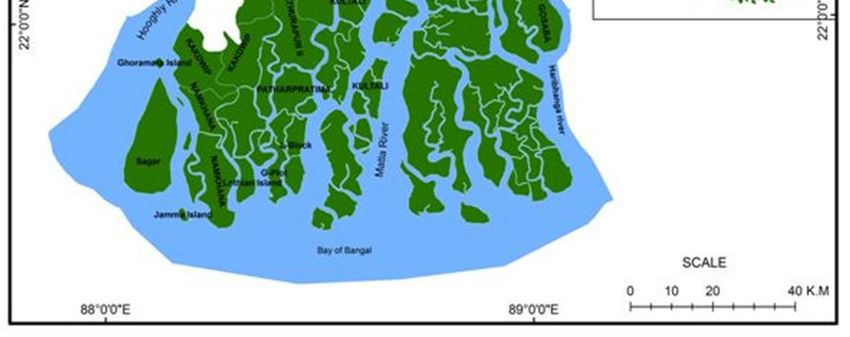
Panchanan Das et al., IJSRR 2019, 8(1), 992-1006

utilization of the resources. The application geospatial technology in estuarine ecology is unpredicted
thing, so it utilize has been data management, mapping of different segments and analysis of
attributes. The difficulty studying an estuarine ecology is that highly dynamic. So, the water
parameter likes pH, Salinity, BOD, TDS and Turbidity etc. are changed automatically. The
Geospatial technology provides an easy technique to current data concerning the spatial investigation
of an estuary. The Spatial base models are used to predict the effects of different object of the
environment.
       This study seeks to find the fishery resources of important estuaries in Sundarban through
spatial technology. The aim of the study is that the present status of the ecological estuarine water
bodies and its water quality analysis through spatial technology and assessment of fishery resources
in Sundarban, West Bengal, India. The objectives of research work are the ecological status of
estuaries and wetland mapping through geospatial technology. So here, this type’s work does not do
so that, we prepared a paper to shows scenario of actual situation of the ecological estuarine water
bodies, water quality and fishery resources. It is also the analysis of water quality parameters and
assessment fishery resources management to uplift of the society. The Sundarban estuaries wetland
(Fig.1) is involved of Hooghly-Matla-Bidyadhari River to create a fishing ground. It is located
between latitude 220 41' 47'' to 210 29' 34'' N and longitude 880 2' 13'' to 890 6' 35’’E of 24pargona in
West Bengal, India. The Sundarban estuaries are low flat alluvial plain covered by mangrove
swamps and so many types of tidal rivers crisscross the region. The Hooghly river received great
amount of freshwater and sediment from the Ganga river.

                                                Fig. 1: Location Map

IJSRR, 8(1) Jan. – Mar., 2019                                                              Page 994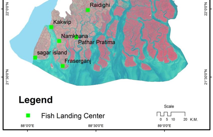
Panchanan Das et al., IJSRR 2019, 8(1), 992-1006

MATERIALS AND METHODS
Data Used
       The Landsat 7 ETM+ data (Sources- GLCF http://glcf.umd.edu/) is used to prepare
estuary and wetland Mapping. The Unsupervised classification technique is used to extract for
wetland resources. The several steps are involved from selection of satellite image data, spatial
resolution, and geo-referencing, image processing and unsupervised classification. In the study,
the unsupervised classification technique has been applied to extract the waterbody from image.
The LANDSAT 7 ETM+ data have been used to map and analyze, it is downloaded from GLCF
website. The Fish base website database gateway is used for fish documentation, identification
and analysis of present status in the Sundarban region.

Physiographic of Coastal Ecological Estuarine Wetland:
       The water temperature ranges between 19.0 - 34.2 OC. It reaches the maximum in May-June
and lowest in December-January. During monsoon, flood water dominates limiting the influence of
seawater. The high temperature of summer increases evaporation, resulting in high salinity. (T.
Srinivasa Kumar9 et al. 2011). The alteration in salinity has a high probability to disrupt the
phytoplankton community (Mitra10 et al. 2005). The water masses are the most necessary criteria for
salinity and temperature. The Alluvial & Salty clay soil types dominate the estuary (Fig. 2). The
Sundarban wetland is a compressive ecosystem around by Hooghly River, Matla River and
Harinbhanga River. So, it is involving of different type’s flora and fauna. Here so many types of
delta like that is muringanga, Saptamukhi, Thakuran-Matla, Bidya, moni, Karati, Gosaba, Kulti,
Bidyadhari, Gomas, Gnasuba and Haldi.

Physico- Chemical Assessment of Water Quality:
       The physical, chemical Parameter had defined those characteristics of water quality.
Temperature: Temperature is one of the important parameter that impact on the physical chemical
and biological aspects belong to water. The temperature is calculated in the survey using a
thermometer instatement with a Celsius scale.
pH: Potential Hydrogen is the measure of the concentration of hydrogen ions. It is impacting the
measurement scale of 0-14 in pH.
Salinity: Salinity is the measure of all the salt dissolved in water. So, it’s usually assessing in parts
per thousand that measure of every kilogram of sea water where 35% are salt.
BOD: Biochemical oxygen demand (BOD) in the measure of dissolved oxygen require by shape of
water. BOD measurement in the assumption on two way, one is measured instantly for dissolved

IJSRR, 8(1) Jan. – Mar., 2019                                                              Page 995
Panchanan Das et al., IJSRR 2019, 8(1), 992-1006
oxygen and the second is incubated in the lab for 5days and then tested for the amount of dissolved
oxygen.
Dissolved Oxygen (DO): The important of dissolved oxygen (DO) are connected with fish life and
aquatic organisms. The water quality is suitable for fish ecology status habitats. DO content is a
process of bio-chemical Indicates the health and ability of the water.
TDS: Total dissolved solids are measures of the connected content of all organic and inorganic
substances carry out in a liquid in molecular and micro-suspended form. The main application of
TDS is in the study of water quality for different waterbody.
Turbidity: Turbidity is a measure of the degree to which the water loses its transparency due to the
presence of suspended particulates.
Field observation data have been accumulated from the period of November to February in
the year 2017-18. The samples are collected from different site in Sundarban region. The GPS survey
has been done for ground truth verification and validation. The People of Sundarban are depending
on agriculture, livestock, fisheries & forestry. In Sundarban, Forty four percent of total population
belong to SC and ST. The level of literacy as well as per capital income is much lower in Sundarban
than in other parts of West Bengal.
RESULTS AND DISCUSSIONS
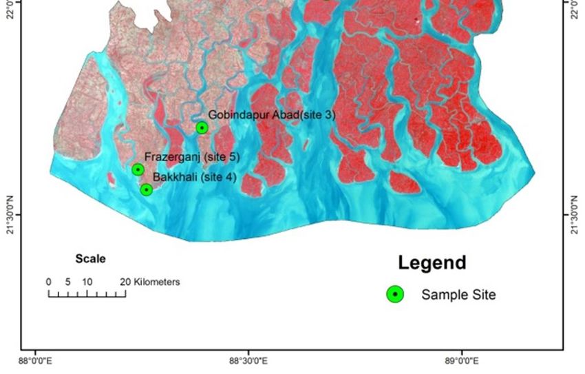
Waterbody Mapping and Water Quality Analysis:
The wetland map of Sundarban & adjoin area waterbody are extracted from image to prepare
a waterbody map using geo-informatics platform. The Spectral signature is an innovation of
reflectance within the most important to extract waterbody from image data. The comparisons of
signature with other targets are water bodies showing a weak reflectivity, manifested in the
wavelength range of visible light. Because the water bodies receive strong absorption at the near IR
band and mid-IR band, this wavelength range can be applied to separate water from soil, vegetation,
buildings and other ground targets. The final extracted map (Fig. 2) shows the complete wetland map
of Sundarban region. The wetland is engaged to lake, swamps and bheries in the Sundarban delta
area. The Sundarban estuary area is crisscrossed by number of Streams, Rivulets, Creeks and
Channel. Other major estuaries are Muringanga, Saptamukhi and Thakuran-Matla while the minor
estuaries are moni, Karati, Gosaba, Kulti, Bidyadhari, Gomas, Haldi and now considered as estuaries
inlets carrying tidal brackish water.
Water quality parameter is using the present status of water content for health of aquatic life.
So, In Sundarban we are identifying eight comparative survey location site (Fig. 3) are Canning as
site 1, Jharkhali as site 2, Gobindapur as site 3, Bokkhali as site 4, Freserganj as site 5, Basanti as site
IJSRR, 8(1) Jan. – Mar., 2019 Page 996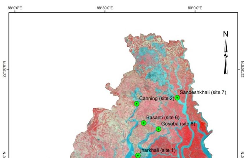
Panchanan Das et al., IJSRR 2019, 8(1), 992-1006

6, Sandeshkhali as site 7, Gosaba as site 8 to present of parameters that is Temperature, pH, Salinity,
BOD, dissolved oxygen (do), TDS, Turbidity parameters to assessment of water quality.

            Fig. 2: Waterbody Map                                   Fig. 3: Sample Site Map

        All parameters are collecting field data to High Tide and Low tide sequences of those sites.
High tide time of Air temperatures is maximum of 26.7° C in Freserganj and minimum of 25.3°C in
Gosaba where low tide time of Air temperature is          maximum of 27.7°C in Sandeshkhali and
minimum of 25.35°C in Canning and also (Fig.4) is showing all sight of air temperature condition of
during high and low tide. During high tide of water temperatures is maximum of 25.6°C in Jharkhali
and minimum of 24.8°C in Gobindapur where low tide of water temperature is maximum 26.1°C in
both of Gosaba and Freserganj, and minimum of 24.2°C in Canning and also (Fig.5) is showing all
sight of water temperature status of high and low tide. During high tide, pH reading is maximum of
7.9 in Bokkhali and minimum of 7.4 in both of Basanti and Sandeshkhali where during low tide; pH
is maximum of 7.9 in Gosaba and minimum of 7.5 in Gobindapur and also (Fig.6) is showing all site
of pH conditions of high and low tide period. In high tide, Salinity is maximum of 23.58% in
Freserganj and minimum of 9.68% in Canning. Where In low tide, salinity is maximum of 23.57% in
Freserganj and minimum of 9.4 % in Canning and also (Fig.7) is showing all sight of salinity status of
high and low tide. During high tide of turbidity is maximum of 310 ntu in Bokkhali and minimum is

IJSRR, 8(1) Jan. – Mar., 2019                                                             Page 997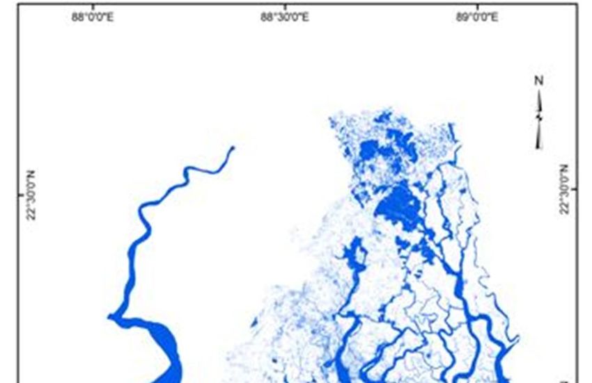
Panchanan Das et al., IJSRR 2019, 8(1), 992-1006

94.5 ntu in Jharkhali where in low tide, turbidity is maximum of 249ntu in Freserganj and minimum is
168.5ntu in Canning and also (Fig.8) is shows of present condition of turbidity during high and low
tide. In high tide, Dissolved Oxygen is maximum of 7.68 mg/L in Canning and minimum of 6.18 mg/L
in Bokkhali where low tide Dissolved Oxygen is maximum of 7.58 mg/L in Canning and minimum of
6.08 mg/L in Gobindapur and also (Fig.10) is shows of present condition of Dissolved Oxygen during
high and low tide. In high tide, BOD is maximum of 3.1 mg/L in Canning and minimum of 2.43 mg/L in
Gobindapur where low tide BOD is maximum of 3.2 mg/L in Sandeshkhali and minimum of 2.03
mg/L in Gobindapur and also (Fig.9) is shows of present condition of BOD during high and low tide.
In high tide, TDS is maximum of 23650 mg/L in Freserganj and minimum of 17050 mg/L in Jharkhali
where low tide TDS is maximum of 21000 mg/L in Freserganj and minimum of 14560 mg/L in
Canning and also (Fig.11) is shows of present condition of TDS during high and low tide. So, Table-
1 database are shown in bar graph diagram and analysis of data are suitable for fish ecology and
habitats.

 28
27.5
 27
26.5
 26
25.5
                                                                             Temp (°C) air High Tide
 25
                                                                             Temp (°C) air Low Tide
24.5
 24

                                      Fig.4: Air Temperature

IJSRR, 8(1) Jan. – Mar., 2019                                                          Page 998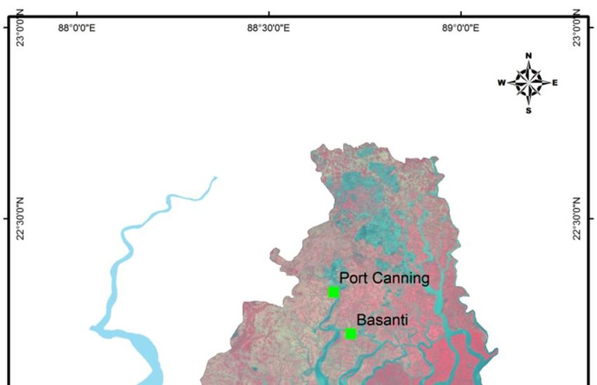
Panchanan Das et al., IJSRR 2019, 8(1), 992-1006

26.5
  26

25.5

  25

24.5

  24                                                                         Temp (°C) water High Tide
                                                                             Temp (°C) water Low Tide
23.5

  23

                                    Fig. 5: Water Temperature

 8
7.9
7.8
7.7
7.6
7.5
7.4                                                                                      pH High Tide
7.3                                                                                      pH Low Tide
7.2
7.1

                                            Fig. 6: pH

IJSRR, 8(1) Jan. – Mar., 2019                                                           Page 999
Panchanan Das et al., IJSRR 2019, 8(1), 992-1006

25

20

15

10
                                                                                   Salinity(%) High Tide
5                                                                                  Salinity(%) Low Tide

0

                                          Figure 7: Salinity

 350
 300
 250
 200
 150
 100                                                                         Turbidity(NTU) High Tide
     50
                                                                             Turbidity(NTU) Low Tide
     0

                                           Fig.8: Turbidity

IJSRR, 8(1) Jan. – Mar., 2019                                                       Page 1000
Panchanan Das et al., IJSRR 2019, 8(1), 992-1006
3.5
3
2.5
2
1.5
1 BODs(mg/L) High Tide
0.5 BODs(mg/L) Low Tide
0
Fig. 9: BOD
9
8
7
6
5
4
3 Dissolved Oxygen(mg/L) High Tide
2
Dissolved Oxygen(mg/L) Low Tide
1
0
Fig. 10: Dissolved Oxygen
IJSRR, 8(1) Jan. – Mar., 2019 Page 1001Panchanan Das et al., IJSRR 2019, 8(1), 992-1006
25000
20000
15000
10000
TDS(mg/L) High Tide
5000
TDS(mg/L) Low Tide
0
Fig. 11: TDS
IJSRR, 8(1) Jan. – Mar., 2019 Page 1002Panchanan Das et al., IJSRR 2019, 8(1), 992-1006
TABLE- 1: Field data collected from 8 sites in Sundarban
High/Low Site Site Site Site Site Site 7 Site 8
Parameter Site 6 (Basanti)
Tide 1(Canning) 2(Jharkhali) 3(Gobindapur) 4(Bokkhali) 5(Freserganj) (Sandeshkhali) (Gosaba)
Temp (°C) air HT 25.8 26.5 26.3 26.5 26.7 26.3 26.4 25.3
LT 25.35 27.5 25.65 26.5 26.9 27.6 27.7 26.9
Temp (°C) water HT 25.35 25.6 24.8 25.15 25.55 25.4 25.4 25.2
LT 24.2 25.35 24.4 25.45 26.1 25.9 25.9 26.1
pH HT 7.7 7.5 7.6 7.9 7.7 7.4 7.4 7.5
LT 7.65 7.6 7.5 7.7 7.6 7.6 7.8 7.9
Salinity (g/kg)% HT 9.68 14.97 12.94 21.9 23.58 14.27 14.29 14.39
LT 9.4 15.23 12.85 22.06 23.57 15.43 15.24 15.49
Turbidity (NTU) HT 110 94.5 134 310 235 94.9 95.01 94.74
LT 168.5 175 172.5 194 249 176 175.9 176
Dissolved HT 7.68 6.6 6.28 6.18 6.57 6.5 6.6 6.7
Oxygen(mg/L)
LT 7.58 6.19 6.08 6.92 7.09 6.09 6.9 6.9
HT 3.1 2.64 2.43 2.54 2.85 2.54 2.58 2.89
BODs(mg/L)
LT 3.04 3.1 2.03 2.64 2.24 3.1 3.2 2.29
TDS(mg/L) HT 17860 17050 18200 21800 23650 21780 21790 22180
LT 14560 16280 14580 18850 21000 18730 18740 19730
IJSRR, 8(1) Jan. – Mar., 2019 Page 1003Panchanan Das et al., IJSRR 2019, 8(1), 992-1006
Assessment of fishery resources
The Sundarban is an ideal mangrove ecosystem, which holds up a heavy group of fishes,
shrimp, and edible crab and also provides food. In Sundarban mangrove, exploitation of major fish
groups like white fish and marketable shrimp are diluted over the years, whereas catch of Scylla
serrata shows an increasing movement. Its rivers, rivulets and creeks with tidal saline waters and
flushing fresh waters provide the ideal ecotonal zone for the development and propagation of many
populations of various fish species (Mandal11 et al. 2013). It is the area where economic benefit
fishes are identifying to 111 species in Sundarban
region. The fish database is prepared for shows
the fish species Scientific Name, Class, Order,
Family, IUCN Status and images. The IUCN
status is shown in Not evaluated (NE), Least
concern (LC), and near threatened (NT)
categories. Out of 111 fish species not evaluated
are 79, least concern are 27, near threatened are
two & the data deficient species are three
numbers identified. The fishing landing centre
map of this area is prepared to show the landing
centre like as Port Canning, Basanti, Raidighi,
Pathaprotima, Frazergunj, Ganga Sagar, Jambu
Island & Main landing stations like as Diamond
Harbour, Kakdwip and Namkhana of Sundarban
adjoin area (Fig.12). Fig.12: Fish Landing Center Map
CONCLUSION
The Sundarban fishery resources are the most fish potentiality zones and productive ground
of estuarine ecosystem coastal wetland. So, the pisciculture is depended on physico-chemical and
bio-chemical parameter of water quality and also ecological of habitats. The result of parameters of
Temperature, pH, Salinity, BOD, dissolved oxygen (DO), TDS, Turbidity is assessments that
positive for health of water and aquatic life growth. So, the water bodies are needed for mapping to
management and conservation those areas where fishery resource is near threatened and substance of
ecology. So, the area of Sundarban has required immediate attention for fishery resource
management and conservation for upliftment of the society.
IJSRR, 8(1) Jan. – Mar., 2019 Page 1004Panchanan Das et al., IJSRR 2019, 8(1), 992-1006
REFERENCES
1. Mitra A, Choudhury A, Zamaddar YA. :Seasonal variations in metal content in the gastropod
Cerithedia (Cerithideopsis) cingulata, Proc Zool Soc, 1992; 45: 497-500
2. Mitra A, Mondal K, Banerjee K. :Concentration of heavy metals in fish juveniles of Gangetic
delta of West Bengal, India., Res. J. Fish & Hydrobiol., 2010; 5(1); 21-26
3. Sengupta K, Roy Chowdhury M, Bhattacharya SB, Raha A, Zaman S, Mitra A. :Spatial
variation of stored carbon in Avicennia alba of Indian Sundarbans., Discovery Nature. 2013;
3(8), 19-24
4. Raha AK, Bhattacharyya SB, Zaman S, Banerjee K, Sengupta K, Sinha S, Sett S,
Chakraborty S, Datta S, Dasgupta S, Chowdhury MR, Ghosh R, Mondal K, Pramanick P,
Mitra A. :Carbon census of mangrove vegetation in Indian Sundarbans., Jr of Energy and Evn
Sci (In Press)., 2013
5. Sargaonkar, A., & Deshpande, V., :Development of an overall index of pollution for surface
water based on a general classification scheme in Indian context., Environmental Monitoring
and Assessment, 2003; 89: 43-67.
6. Clark, J.R. 1983. In: :Coastal ecosystem management (a technical manual for the
conservation of coastal zone resources), John Wiley and Sons, New York 1983; 928.
7. Sunirmal Giri and Susanta Kumar Chakraborty, :Assessment of fishery resources in relation
to some physico-chemical parameter of water in Sundarbans Mangrove Ecosystem, India,
Advances in Applied Science Research, 2012; 3(4):2337-2345, ISSN: 0976-8610
8. Chaves Abhijeet Bernard and C. Lakshumanan, :Remote Sensing and GIS- Based Integrated
Study and Analysis for MangroveWetland Restoration in Ennore Creek, Chennai, South
India., Centre for Remote Sensing, Bharathidasan University, Khajamalai Campus,
Trichirappalli-620 023, Tamil Nadu, India. Proceedings of Taal2007: The 12th World Lake
Conference: 2008; 685-690.
9. T. Srinivasa Kumar & R. S. Mahendra & Shailesh Nayak & K. Radhakrishnan & Kali C.
Sahu (2011) :Identification of hot spots and well managed areas of Pichavaram mangrove
using Landsat TM and Resourcesat—1 LISS IV: an example of coastal resource conservation
along Tamil Nadu Coast, India., Springer Science + Business Media B.V.,
10. Mitra A, Banerjee K and Bhattacharyya DP (2005) :Ecological profile of Indian Sundarbans:
pelagic primary producer community, vol. I. WWF-India, West Bengal State Office.,
IJSRR, 8(1) Jan. – Mar., 2019 Page 1005Panchanan Das et al., IJSRR 2019, 8(1), 992-1006
11. Banani Mandal, Arunava Mukherjee, Samir Banerjee :A review on the ichthyofaunal
diversity in mangrove based estuary of Sundarbans., Rev Fish Biol Fisheries, 2011; 23:365–
374.
IJSRR, 8(1) Jan. – Mar., 2019 Page 1006You can also read