Russell Island, Rocky Point - Feasibility for barge/boat ramp Prepared by Boating Infrastructure Unit - February 2019
←
→
Page content transcription
If your browser does not render page correctly, please read the page content below
Russell Island, Rocky Point
Feasibility for barge/boat ramp
Prepared by Boating Infrastructure Unit – February 2019
Contents
Contents                                                                                                                1

Executive summary                                                                                                       1

Assumptions and terminology explanations                                                                                1

Assessment                                                                                                              2

Conclusion                                                                                                              4

Table of figures
Figure 1                                                                                                                3

Executive summary
   •    The Rocky Point site is, through its natural attributes (in particular the rocky nature of the off-lying seabed),
        unsuited to the economic establishment of a barge/boat ramp.

Assumptions and terminology explanations
   •    A mid-sized barge, like those servicing the Southern Moreton Bay Islands, is assumed – that is, one having a hull
        length of about 37 metres and draught of about 1.6 metres. Note that barges operating in Moreton Bay range in
        length up to 68 metres with 2.0 metres draught.
   •    An acceptable slope for a barge/boat ramp is 1 in 8.
   •    The toe of a barge/boat ramp would be 0.9 metre below the level of Lowest Astronomical Tide (LAT, low water, or
        chart datum). This level equates to -2.0 metres on the datum of the attached survey (Attachment 1) – Australian
        Height Datum (AHD). AHD equates approximately to Mean Sea Level. For comparison, boat ramps are
        commonly constructed to 0.5 metre below LAT.
   •    On the face of the attached hydrographic survey (Attachment 1) a table is provided to show the relationships
        between datums. In particular, note that LAT is 1.1 metre below AHD – that is, the AHD depths need to be
        corrected by 1.1 metres for LAT depths.
   •    The top of a barge/boat ramp is assumed to be 0.5 metre above the level of Highest Astronomical Tide (HAT).
        0.5m above HAT is the reference standard for construction of Transport and Main Roads (TMR) car-trailer parks.
        This level equates to +2.03 metres on the datum (AHD) of the attached survey (Attachment 1).
   •    The draught of a barge is assumed to be maximum towards its stern, and the draught forward is assumed to be
        less – therefore requiring less depth of water at the ramp toe than the barge’s maximum draught.
   •    Barges are assumed to require either clear/deep water off a ramp (like the High Street Russell Island barge ramp
        site), or a manoeuvring basin equating to approximately twice their length to safely go astern, swing, and
        otherwise manoeuvre the barge safely at low tide and in strong wind conditions without risking grounding.

 Russell Island, Rocky Point – Feasibility for barge/boat ramp                                                              -1-
• The master of a barge of 1.6 metre draught is assumed to require a minimum of 0.5 metre under keel clearance
(UKC) to operate safely, noting the rocky nature of the seabed off Rocky Point. This is 2.1 metres (1.6 + 0.5)
below the level of LAT. This equates to a depth on the datum (AHD) of the attached survey (Attachment 1) of
3.2 metres (2.1 + 1.1). An access channel and swing basin of minimum 2.1 metres depth below LAT (3.2 metres
below AHD) are therefore assumed to be needed.
• An access channel for a 37 metres barge is assumed to need a minimum of 35 metres width for safe navigation.
For comparison, the entrance channel to Manly Boat Harbour is 50 metres wide.
• Such an access channel would need to be marked by navigation aids at its outer and inner ends, as would the
limits of any swing basin near the barge/boat ramp.
• A barge/boat ramp would require a suitable parking/waiting and vehicle manoeuvring area near the top of the
ramp. Such an area would need to be constructed to sufficient load bearing capacity to withstand use by barge
loads – for instance, trucks, semi-trailers, fire engines, 4WD wagons towing boats up to 9 metres. The reference
standard for TMR two-lanes ramps is a manoeuvring area plus parking for 45 car-trailer units, and for single-lane
ramps a manoeuvring area plus parking for 15 car-trailer units. A single-lane ramp with 15 car-trailer unit parking
spaces plus manoeuvring/waiting area is assumed for this assessment.
• The access road to the barge/boat ramp would need to be built to a construction standard, and width, suitable for
the above-mentioned traffic loads and areas. Councils provide such land-side facilities and infrastructure.
Assessment
• A hydrographic survey (Attachment 1) has been provided by TMR to facilitate this feasibility study. The attached
survey is in PDF format and may be zoomed in to examine detail.
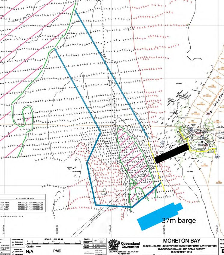
• On the next page is Figure 1 – an annotated extract from the hydrographic survey. A scale is shown at the
bottom. Annotations include:
o a green line marking the limits of barge navigable depths (2.1 metre LAT, equals 3.2m AHD)
o pink cross-hatching to emphasise the limits of the green line navigable areas – an isolated basin near
Rocky Point – and the deeper waters of the north-south channel off-lying and west of Russell Island
o a yellow line onshore at Rocky Point, marking 0.5 metre above HAT (2.03 metre above AHD)
o a yellow line to mark the toe of a potential barge/boat ramp – at 0.9 metre below LAT (2.0 metres below
AHD)
o a blue 37-metre-length barge to assist with perception of scale
o blue lines showing a 35-metre-wide access channel needed to be dredged/excavated to connect the
deeper waters offshore to the swing basin near the toe of the barge/boat ramp
o more blue lines to show the approximate limits of a dredged/excavated swing basin, noting that the
central part of the swing basin is already deeper than 2.1 metres LAT
o a black barge ramp of approximate width 5 metres and approximate length 34 metres.
Russell Island, Rocky Point – Feasibility for barge/boat ramp -2-Figure 1
• The distance between the two yellow lines is approximately 34 metres. With the upper line (car-park) at
2.03 metres above AHD and the ramp toe 2.0 metres below AHD, the average slope of the foreshore is 1 in 8.4
(34/4.03). This indicates a barge/boat ramp of slope 1:8 could be constructed in the position shown.
Russell Island, Rocky Point – Feasibility for barge/boat ramp -3-• The natural basin out from the toe of the barge/boat ramp, shown edged green and cross-hatched pink in
Figure 1, is insufficient to safely float a barge of 37 metres length with an adequate safety margin astern. Nor is
the natural basin adequate for a 37-metre barge to safely navigate to and swing onto the barge/boat ramp on
arrival. Nor is the natural basin sufficiently adequate in size for a 37-metre barge to retract astern and swing
safely on departure, particularly in strong wind conditions.
• There is an extensive area of hard (rocky) seabed material within the swing basin – shown in red soundings and
by “rocks” annotation. This is consistent with the site being named Rocky Point.
• A 35-metre-wide access channel would need to be dredged in part (soft material) and excavated in part
(hard/rocky material).
• Initial capital dredging/excavation would need to be followed by periodic maintenance dredging into the long-term
future. This is because sedimentation would occur through nature responding to man-made intervention by
returning the seabed to its natural state. This is the reason for all dredged areas (including ports) requiring
periodic maintenance dredging.
• Six navigation aids would need to be established to mark the entrance channel and limits of the swing basin.
• Rocky Point is exposed, especially at high tides, to a considerable fetch (distance over water the wind can blow to
increase wave heights). This is particularly so for strong north-westerly, westerly, and south-westerly winds.
• Reports of the site being used for access by smaller trading vessels (like the historic ‘Dawn’) appear reasonable,
as such vessels are/were of much shallower draught, beam and length compared to mid-sized barges.
Conclusion
• The Rocky Point site is, by its natural attributes (in particular the rocky nature of the off-lying seabed), unsuited to
the economic establishment of a barge/boat ramp.
• The site is potentially suitable for establishment of a jetty with fixed stage landings. It would not be wheelchair
accessible. Its use would be limited to times when strong winds were not blowing from the north-west, west, or
south-west.
• The site is unsuitable for a pontoon, owing to exposure to wave action, unless it were a major jetty/pontoon
structure like the multi-million dollar ferry terminal at Coochiemudlo Island.
Creative Commons information
© State of Queensland (Department of Transport and Main Roads) 2015
http://creativecommons.org.licences/by/4.0/
This work is licensed under a Creative Commons Attribution 4.0 Licence. You are free to copy, communicate and adapt the work, as
long as you attribute the authors.
The Queensland Government supports and encourages the dissemination and exchange of information. However, copyright protects
this publication. The State of Queensland has no objection to this material being reproduced, made available online or electronically
but only if its recognised as the owner of the copyright and this material remains unaltered.
The Queensland Government is committed to providing accessible services to Queenslanders of all cultural and
linguistic backgrounds. If you have difficulty understanding this publication and need a translator, please call the
Translating and Interpreting Service (TIS National) on 13 14 50 and ask them to telephone the Queensland Department
of Transport and Main Roads on 13 74 68.
Disclaimer: While every care has been taken in preparing this publication, the State of Queensland accepts no responsibility for
decisions or actions taken as a result of any data, information, statement or advice, expressed or implied, contained within. To the best
of our knowledge, the content was correct at the time of publishing.
Russell Island, Rocky Point – Feasibility for barge/boat ramp -4-You can also read