Mesozoic Tectonic and Paleogeographic Evolution of the Gulf of Cadiz and Algarve Basins, and Implications for Hydrocarbon Exploration
←
→
Page content transcription
If your browser does not render page correctly, please read the page content below
Mesozoic Tectonic and Paleogeographic Evolution of the Gulf of Cadiz and Algarve Basins, and Implications for
                                           Hydrocarbon Exploration*

                        Adrià Ramos1, Oscar Fernández3, Pedro Terrinha4, Josep Anton Muñoz2, and Álvaro Arnaiz3

                                                      Search and Discovery Article #10621 (2014)**
                                                                      Posted August 11, 2014

*Adapted from oral presentation given at AAPG 2014 European Regional Conference & Exhibition, Barcelona, Spain, May 13-15, 2014
**AAPG©2014 Serial rights given by author. For all other rights contact author directly.

1
  Geomodels, Departament de Geodinàmica i Geofísica, Universitat de Barcelona, Barcelona, Spain (adriaramos@hotmail.com)
2
  Geomodels, Departament de Geodinàmica i Geofísica, Universitat de Barcelona, Barcelona, Spain
3
  Grupo de Disciplinas Geológicas, REPSOL Exploración, Madrid, Spain
4
  InstitutoPortuguês do Mar e da Atmosfera, Divisão de Geologia e Georecursos Marinhos, Lisboa, Portugal

                                                                            Abstract

The Gulf of Cadiz and its western extension, the Algarve Basin, are located along the eastern termination of the Azores-Gibraltar Fault Zone
(AGFZ), a diffuse transforming plate boundary between Iberia and Africa (Sartori et al, 1994). This area has experienced significant
hydrocarbon exploration in the past dealing with both the Mesozoic platform carbonates and the Tertiary units of the Gulf of Cadiz, the latter
related to the deposition of Guadalquivir-sourced sediments and contourites.

Over the last years several models have been proposed for the regional geodynamic evolution of the Gulf of Cadiz (e.g. Tortella et al., 1997,
Maldonado et al., 1999; Gutscher et al, 2002; Gràcia et al., 2003) that generally coincide in defining two main phases of evolution. The Gulf of
Cadiz began to develop as a rift basin along the SW margin of the Iberian plate from the Jurassic to the Cretaceous (Terrinha 1998, Maldonado
et al., 1999; Matias et al., 2005; Mohriak 2005, Mohriak et al., 2008). The basin underwent tectonic inversion episodes between phases of
rifting (Terrinha et al., 2002). During the Late Cretaceous to the Holocene, the area underwent contraction normal and oblique to the
extensional margin due to convergence between Africa and Iberia.

Regional seismic data, well data, field data from onshore Portugal and gravity and magnetic data have been integrated to define a coherent
regional structural framework to explain the Mesozoic evolution of the SW Iberian margin. Firstly this passive margin underwent NNW-SSE
(in present-day coordinates) mild extension during the Early Jurassic, with a regional system of kilometer-scale extensional faults and
associated basins defining multiple isolated depocenters with limited subsidence. From the Middle Jurassic through the Early Cretaceous,
extension progressed and developed basin-scale faults defining depocenters that accommodated subsidence of 100s to over 1000 meters. This
major Mesozoic extensional event marks the onset of salt mobilization throughout the basin, resulting in multiple diapirs, and culminating in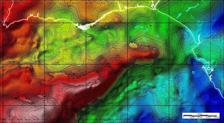
the emplacement of an allochthonous salt body during the Late Jurassic-Early Cretaceous transition. The basins were bounded to the south by
the offshore Guadalquivir Bank.

Extensional features and salt structures were reactivated during the Late Cretaceous to Tertiary convergence of Iberia and Africa. In some
cases, this resulted in complex inversion structures which have been poorly understood until now, and in the contractional reactivation of salt
diapirs and structures. This tectonic event is also responsible for the late uplift of the Guadalquivir Bank.

Our observations depocenter orientations and sedimentary polarity indicate that during the Mesozoic the Central Algarve and Gulf of Cadiz
opened towards the present-day south-east. This is consistent with this region being the western continuation of the Tethyan domain between
Iberia and Africa. On the other hand, the basin's westernmost segment (western Algarve and Sagres area) marks the transition to the Boreal
domain.

The structural framework defined in this paper provides strong constraints on the possible development of, up to now unproven, Mesozoic
hydrocarbon systems. Jurassic facies and depocenters were strongly controlled by the developing half-grabens and salt structures, and source
rock distribution in addition to subsequent maturation was strongly controlled by ongoing subsidence and Cretaceous sedimentation.

                                                                References Cited

Duarte, J.C., M.F. Rosas, P. Terrinha, M.A. Gutscher, J. Malavieille, S. Silva, and L. Matias, 2011, Thrust-wrench interference tectonics in the
Gulf of Cadiz (Africa-Iberia Plate boundary in the North-east Atlantic); insights from analog models:
Marine Geology, v. 289, p. 135-149.

Frizon, D. de Lamotte, C. Raulin, N. Mouchot, W.D. Jean-Christophe, C. Blanpied, and J.C. Ringenbach, 2011, The southernmost margin of
the Tethys realm during the Mesozoic and Cenozoic; initial geometry and timing of the inversion processes: Tectonics, v. 30/3, p. TC3002.

Gràcia, E., J. Dañobeitia, J. Vergés, R. Bartolomé, and D. Córdoba, 2003, Crustal architecture and tectonic evolution of the Gulf of Cádiz (SW
Iberian margin) at the convergence of the Eurasian and African plates: Tectonics, v. 22/4, p. 1033–1051.

Gutscher M.A., J. Malod, J.P. Rehault, I. Contrucci, F. Klingelhoefer, L. Mendes-Victor, and W. Spakman. 2002, Evidence for active
subduction beneath Gibraltar: Geology, v. 30/12, p. 1071-1074.

Maldonado, A., L. Somoza, and L. Pallarés, 1999, The Betic orogen and the Iberian–African boundary in the Gulf of Cádiz: geological
evolution (central North Atlantic): Mar. Geol., v. 155/1–2, p. 9–43.

Matias, L., A. Ribeiro, M.A. Baptista, N. Zitellini, J. Cabral, and P. Terrinha, 2005, Lisbon 1755; a case of triggered onshore rupture?: Bulletin
of the Seismological Society of America, v. 95/6, p. 2534-2538.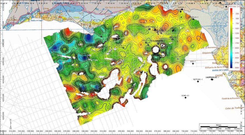
Mohriak, W.U., 2005, Salt tectonics on the South Atlantic margins; analogies with the North Atlantic basins: Program with Abstracts
Geological Association of Canada, Mineralogical Association of Canada Joint Annual Meeting, v. 30, p. 132-133.

Mohriak, W.U., M. Nobrega, M.E. Odegard, B.S. Gomes, and W. Dickson, 2008, Geological and geophysical interpretation of the Rio Grande
Rise, southeastern Brazilian margin; extensional tectonics and rifting of continental and oceanic crusts: Geological Survey of London, London,
United Kingdom, p. 71-72.

Sallarès V., A. Gailler, M.A. Gutscher, D. Graindorge, R. Bartolomé, E. Gràcia, J. Díaz, J.J. Dañobeitia, and N. Zitellini, 2011, Seismic
evidence for the presence of Jurassic oceanic crust in the central Gulf of Cadiz
(SW Iberian margin): Earth and Planetary Science Letters, v. 311/1–2, p. 112-123.

Sartori, R., L Torelli, N. Zitellini, D. Peis, and E. Lodolo, 1994, Eastern segment of the Azores-Gibraltar line (central-eastern Atlantic): An
oceanic plate boundary with diffuse compressional deformation: Geology, v. 22/6, p. 555-558.

Schetino, A., and E. Turco, 2011, Tectonic history of the western Tethys since the Late Triassic: Geological Society of America Bulletin, v.
123/1-2, p. 89-105.

Terrinha, P., 1998, Structural geology an tectonic evolution of the Algarve Basin, South Portugal: Ph.D. thesis, Univ. College of London,
London, UK, 430 p.

Terrinha, P., C. Ribeiro, J.C. Kullberg, C. Lopes, R. Rocha, and A. Ribeiro, 2002, Compressive episodes and faunal isolation during rifting,
Southwest Iberia: J. Geol., v. 110, p. 101–113.

Tortella, D., M. Torné, and A. Pérez-Estaun, 1997, Geodynamic evolution of the eastern segment of the Azores-Gibraltar zone: The Gorringe
Bank and the Gulf of Cadiz region: Mar. Geophys. Res., v. 19, p. 211–230.

Vergés J., and M. Fernàndez, 2012, Tethys-Atlantic interaction along the Iberia-Afraice plate boundary: the Betic-Rif orogenic system:
Tectonophysics, v. 579, p. 144-172.

MESOZOIC TECTONIC AND
PALEOGEOGRAPHIC EVOLUTION OF
 THE GULF OF CADIZ AND ALGARVE
  BASINS, AND IMPLICATIONS FOR
   HYDROCARBON EXPLORATION

                         Adrià Ramos
                     Oscar Fernández
                       Pedro Terrinha
                   Josep Anton Muñoz
                         Álvaro Arnaiz
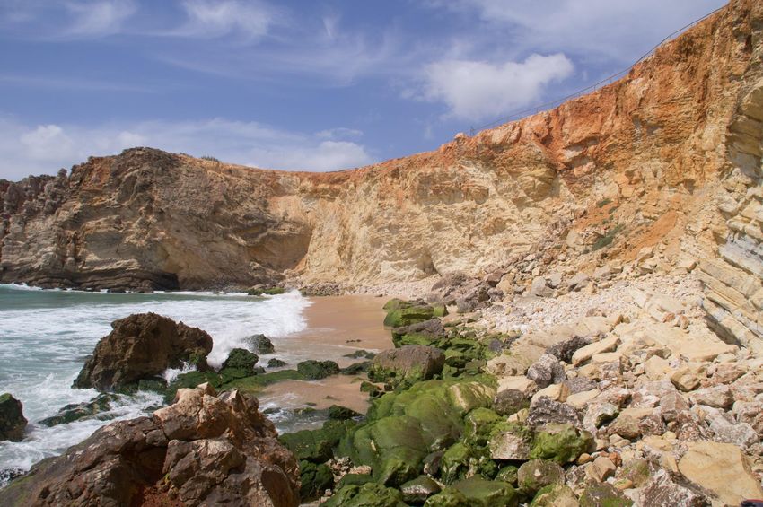
Study Area

                Study Area

Duarte (2011)
HC exploration
GoC intensively studied through the 70s and early 80s.
Mesozoic Play as a target, with no exploration success, due to:
- Failure to find traps and reservoirs
- Complex distribution of the hypothetical Jurassic source
rock
- Poor understanding of the possible migration pathways
Proved Tertiary biogenic gas play: Poseidon field
Proved thermogenic petroleum system in the area: such as the
well known gas chimneys of the GoC.
- The study of the basin structure and its geodynamic evolution will help
to better understand the Mesozoic Play.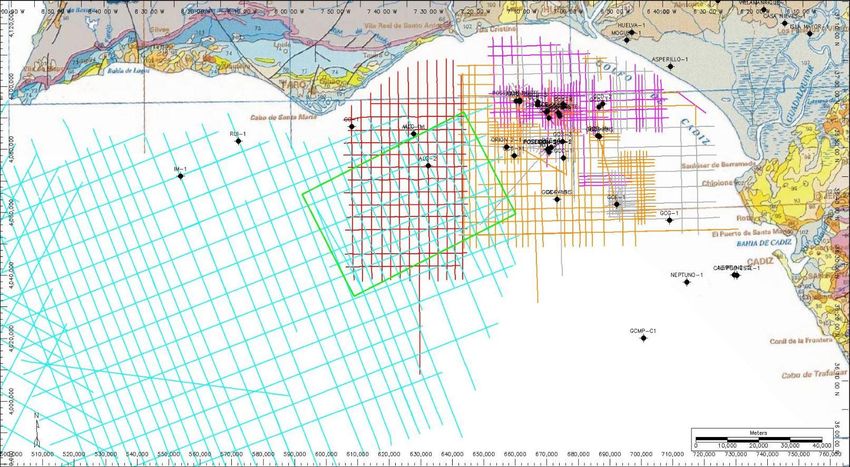
Plate tectonics map
Jurassic to Early Cretaceous: rift basin and tectonic inversion episodes
           Late Jurassic                                  Early Cretaceous

Late Cretaceous to Holocene contractional normal and oblique to the extensional margin
            Late Cretaceous                            Oligocene

 From Schetino and Turco (2010), and edited by Vergés and Fernández (2012)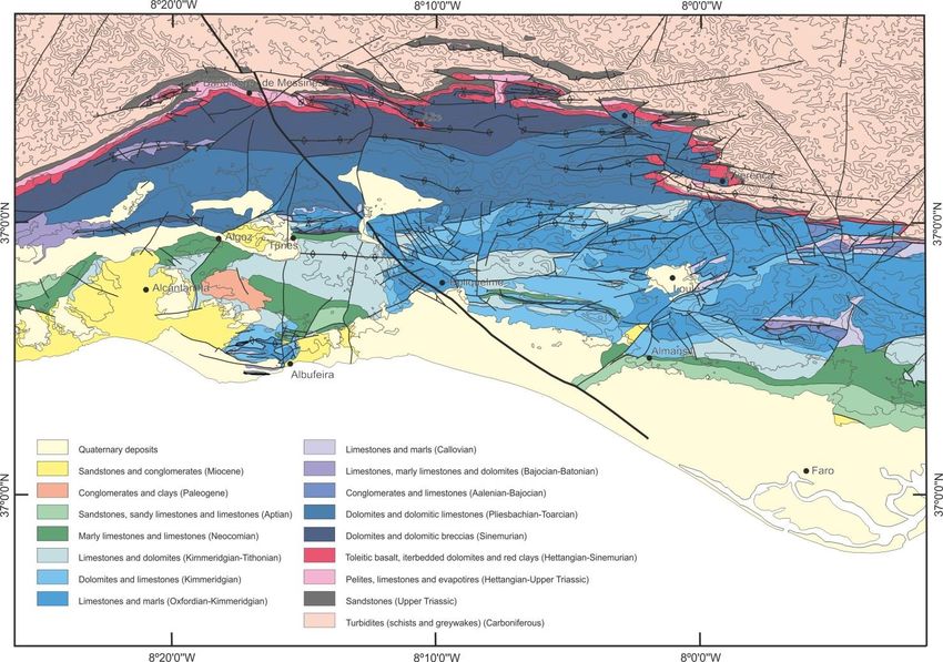
Jurassic Oceanic Crust

                                      Algarve and
                                      Gulf of Cádiz
      Gulf of Cadiz                   basins
      Basement High

                                                            Algarve Basin
                      Gulf of Cadiz
                      Basement High

                                                      Sallarés et al (2011)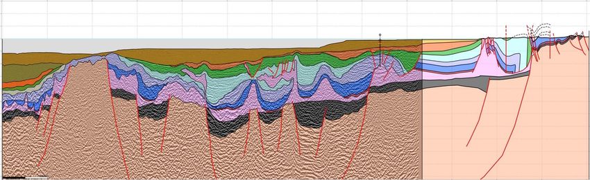
Jurassic basins and oceanic crust
                                       Strike-slip motion

                                        Oblique motion

Frizon et al (2012)

- Strike-slip or extensional regime?
- Transfer faults role?                    Sallarés et al (2011)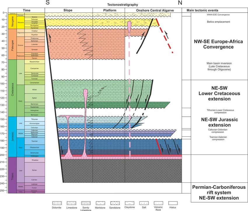
Basin evolution and Petroleum System
                                  R
                             Sb

                                          R

                              R
        Gulf of Cadiz High

                                  S

                                      S
Data
Bibliography Field work Algarve Geological map
Seismic surveys
Bouguer Anomaly map (satellite) Well data
Bouguer Anomaly map (3D seismic)Seismic Surveys
SURVEYS
PDT00_PD00
CHALLENGER74
78
79
Study Area 80_2ms/80_4ms
3D_ALG12_2msGravity anomaly map (Bouguer Res
1VD)
3D Seismic
Gulf of Cadiz
Basement
High
Study AreaOnshore Basin Margin
SMQF
Regional Geological map
Detailed Geological mapCross-sections (map)
A
B
Ruivo-1
B’
A’Central Cross-section
A
B
Ruivo-1
B’
A’
A’ (SE) A (NW)
20000m 40000m 60000m 80000m 100000m 120000m
2000m
Albufeira
Ruivo-1 Diapir
0m Gulf of Cadiz
Basement High
Miocene
-2000m Paleogene L. Cret
Olistostrome
CVS
-4000m U. Jur L. Jur
Hett. Salt M. Jur
-6000m
Trias
-8000m
-10000m
Paleozoic
10000m
Basement
V= 3HEastern Cross-section
A
B
Ruivo-1
B’
A’
B’ (SE) B (NW)
20000m 40000m 60000m 80000m 100000m
2000m
Gulf of Cadiz
0m Basement High
Miocene Paleogene
-2000m
Olistostrome Salt Canopy L. Cret CVS
-4000m
U. Jur M. Jur
L. Jur
-6000m
Trias Hett. Salt
-8000m
-10000m Paleozoic
Basement
9000m
V= 3HTop Basement (isobath map)
Depocenter
Eroded Area
Allochtonous Salt
Late Jurassic
SMQFSMQF
Middle Jurassic
Hettangian Salt
LEGEND
Basement
LEGEND
Basement High
Basement fault
Basement
Extensional high
fault
Thrust fault Gulf of Cadiz
Extensional
Transfer fault fault Gulf Basement
of Cadiz High
Strike-slip fault
Well
Transfer fault Basement HighMiddle-Lower Jurassic (isopach map)
SMQF
LEGEND
Depocenter
Hettangian salt
Basement high
Basement
structuresUpper Jurassic (isopach map) LEGEND SMQF Depocenter Middle Jurassic Hettangian salt Basement high Basement structures
Lower Cretaceous (isopach
 map)

LEGEND
                       SMQF
   Depocenter
   Salt Canopy
   Middle Jurassic
   Hettangian salt
   Basement high
   Basement
   structures
Conclusions
Mesozoic Model and depocentre map
Lower Cretaceous
Depocentre
Jurassic
Depocentres
SMQF
Gulf of Cadiz
Basement HighConclusions
W-E extensional fault system
NW-SE transfer fault system
Important impact for HC systems
Oblique margin between Africa and
IberiaThank you for your attention!
You can also read