The National Archives of the Netherlands: Manuscript maps and digital access
←
→
Page content transcription
If your browser does not render page correctly, please read the page content below
e-Perimetron, Vol. 4, No. 4, 2009 [203-211] www.e-perimetron.org | ISSN 1790-3769
Louisa Balk∗
The National Archives of the Netherlands:
Manuscript maps and digital access
Keywords: Manuscript maps, cartographic heritage, digital access to maps.
Summary
Digital access to manuscript maps is not enough to research the original meaning and archival context of
the maps. Unfortunately manuscript maps are often less accessible since they were frequently separated
from the documents that they illustrated. The lack of standards in the metadata demands different strate-
gies. Using geo-reference to find the maps is one of them, using the knowledge of the public in a web 2.0
environment is another. Working together with Cultural Heritage Institutes that keep the same kind of
maps, Universities and international partners will create solutions for better accessibility of manuscript
maps in the future.
Introduction
The National Archives keeps the archives of government agencies and departments, including ca. 300.000
archival maps and drawings. These archival maps, mostly manuscripts, belong to records and are unique
historical sources. The manuscripts maps are made in the context of planning and control of the governmen-
tal administrations. The map in figure 1 shows the new borders between the Netherlands and Belgium after
their separation in 1839. This was part of the Treaty documents.
Manuscript maps were made with a specific function in a process such as constructing a dike, a law suit, the
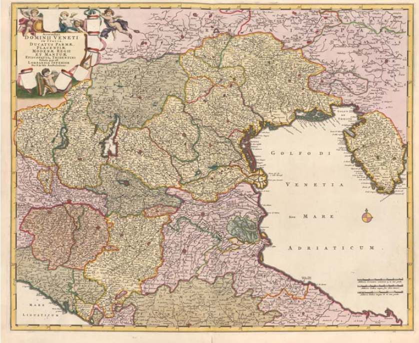
building of a fortification or raising tax. Or the manuscript map of New Netherlands (figure 2), a map that
was given to Dutch explorers from the Dutch Government, the States General, to sail across the Atlantic for
commercial activities in 1614 (4.VEL 520). As a rule manuscript maps are less accessible than printed
maps. You can compare them to handwritten archival documents and printed books. The map of Blaeu (fig-
ure 3), the Atlas Maior, has got a title, a year of creation and a place of publication. It can be retrieved in the
world wide catalogue of libraries (Worldcat for the Dutch known as Picarta) with standard metadata and
descriptions.
But, this is not possible for manuscripts. There is no thesaurus for geographical names like used in libraries.
Historical toponyms changed or disappeared during the centuries. And there is another problem. Because of
their size they were made and kept in special map rooms, or seperated later from the documents that they
originally illustrated. Without the reconstruction of the historical relations, these manuscripts cannot be
used for historical research.
∗
Nationaal Archief, The Hague [louisa.balk@nationaalarchief.nl]
[203]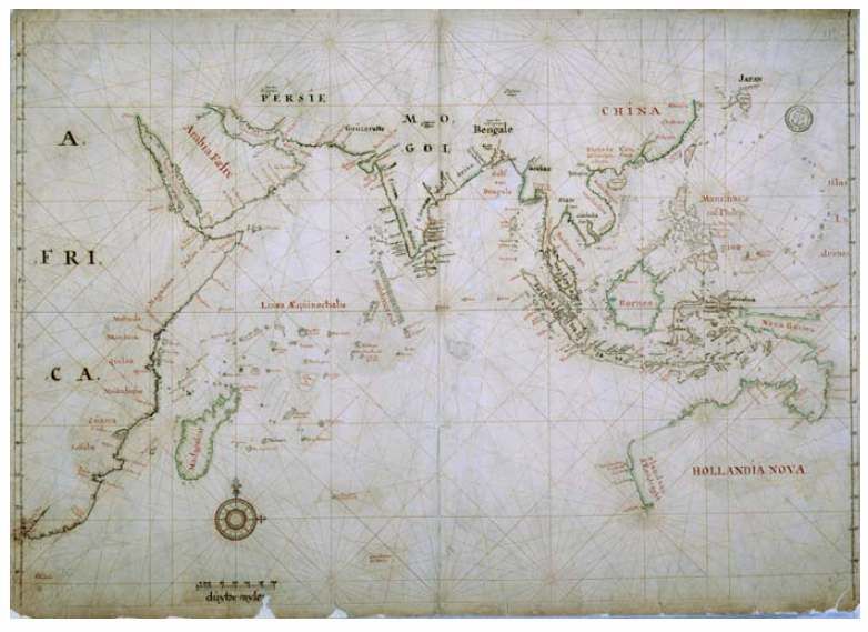
e-Perimetron, Vol. 4, No. 4, 2009 [203-211]               www.e-perimetron.org | ISSN 1790-3769

                                              Figure 1.

                                              Figure 2.

                                               [204]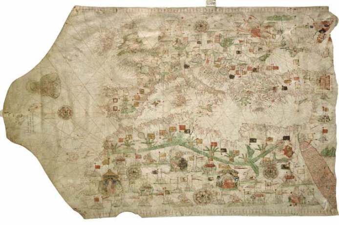
e-Perimetron, Vol. 4, No. 4, 2009 [203-211]                                       www.e-perimetron.org | ISSN 1790-3769

                                                           Figure 3.

                                                   The strategies needed

                                              Digitise as many maps as possible

 Without digital access, the manuscript maps do not exist for most of the researchers. Unfortunately, the
Dutch government only provides budget for developing tools, infrastructure or special projects. Neverthe-
less we managed to put more than 7000 maps on our website and this amount is still growing
(http://beeldbank.nationaalarchief.nl). We also use the high quality scans ordered by the public over the last
years in the Beeldbank. Participation in digitising programms with other Cultural Heritage institutions like
the Rijksmuseum in Amsterdam and the Royal Library in the website of the Atlas of Mutual Heritage gave
the opportunity to digitize many maps of the Dutch East Indies Company an West Indies Company of the
   th       th
17 and 18 centuries.

                                                            [205]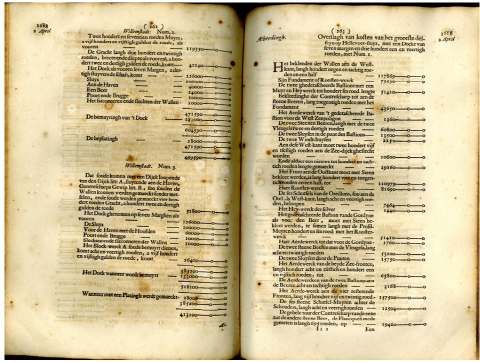
e-Perimetron, Vol. 4, No. 4, 2009 [203-211]                                                          www.e-perimetron.org | ISSN 1790-3769

                             Figure 4. Chart of the Dutch East Indies Company, National Archives, 4.VEL 312 .

                                        Finding aids providing the scans with metadata:

Most of our finding aids of the manuscript maps are digitised in XML with a standard developed Encoded
Archival Description or EAD. This enables the connection of metadata to the images in the database with
images, as well as the connection of the images to the finding aids. This is used in the project to build a
European portal, a gateway to all European archives within the European Digital Libraries.

                               Research on the kind of relations between maps and archives:

Relations between maps and archival documents are not easy to reconstruct. Sometimes there is a date of
the resolution on the map or even in the finding aid of the map collection. Sometimes there is an old number
on the map or a reference in the finding aid of the archives. Research on the pattern of these relations with
different examples, will show the way how to restore them semi-automatically.

                                                                  [206]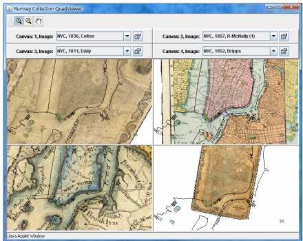
e-Perimetron, Vol. 4, No. 4, 2009 [203-211]                                                           www.e-perimetron.org | ISSN 1790-3769

                             Figure 5. Resolution of Holland, about the harbour of Willemstad, April 2nd 1688.

                              Figure 6. The map of the harbour made for the decision of Holland. 4.OPV W66.
                                        This year we will start a pilot to connect them to their context.

                                                                  [207]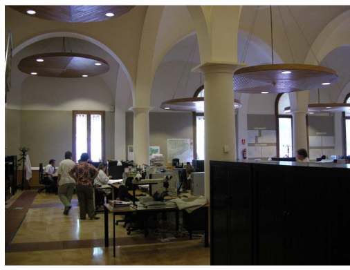
e-Perimetron, Vol. 4, No. 4, 2009 [203-211]                                    www.e-perimetron.org | ISSN 1790-3769

                                                   Geo-reference:

Users of geospatial data want to find their maps as easy as possible and prefer a visual system
like Google Earth. For this purpose, our manuscript maps need to be geo-referenced. Geo-
referencing is adding a standard to the insufficient metadata we already have. When we use
KML for instance, it can be connected to the original metadata in XML. The aim is not to put
them in a perfect fitting GIS-system, because these manuscripts vary in scale, precision, pro-
jection, color, reliability, size and perspective.

    Figure 7. Portolan-map of the Mediterraneum, Russus 1533, NationArchives Collection Hingman, 4.VTH 3803.

Rubber sheeting will not solve all this problems. Geo-reference is just a tool to find the maps
and maybe we can present them next to each other like Rumsey, with the following example
of Manhattan (Figure 8.). Two students of the University of Utrecht did some research on
geo-reference and presentation of manuscript maps and the results were hopeful. We intend
to geo-reference our maps in the near future and hope we can start soon.

                                              Annotation for the public:

Web 2.0is an attractive instrument to involve the public in improving the accessibility of
maps. We have already invited the public to add metadata to our photos and maps in the
Beeldbank. A moderator selects the comments and adds what is useable. Last year we up-
loaded a set of photos on Flickr the commons with the purpose to reach the public and collect
information about tagging the images. This year we want to research tagging on Flickr the
commons with a pilot of 25 manuscript maps on watermanagement.

                                                        [208]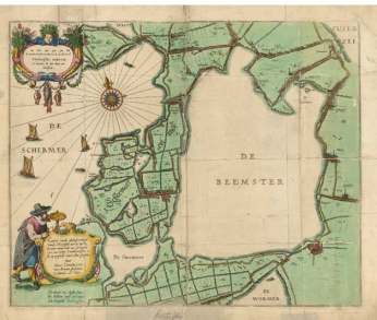
e-Perimetron, Vol. 4, No. 4, 2009 [203-211]                                       www.e-perimetron.org | ISSN 1790-3769

                                                      Figure 8.

          Figure 9. National Archives, Beemster, polder on the Unesco World Heritage list, 1607 4.VTH 2598.

                                                       [209]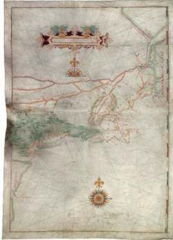
e-Perimetron, Vol. 4, No. 4, 2009 [203-211]                       www.e-perimetron.org | ISSN 1790-3769

We hope to learn from this experiment for our new website. If we give the public the instru-
ment for tagging and annotating the manuscript maps, we expect to be able to connect the
maps to the original context, the archives. Researchers and semi-professionals can help to
find the connection.

                                              A gazetteer:

We analysed gazetteers with a lot of toponyms like the Alexander Digital Library or the
Getty. It would be great to have a gazetteer with possibilities to add historical toponyms and
use the standard to find the map. Recently we consulted José Borbinha (Borbinha et al, 2009;
Manguinhas et al. 2009; Martins et al 2009), who presented the DigMap project last year in
Barcelona. This big European project developed a lot of useful tools for maps, among which
a gazetteer combining abovementioned gazetteers with millions of toponyms and the possi-
bility to add more (historical) geographical names.

                                              Co-operation:

With the University of Utrecth, Department of Information and Computing Sciences (Dr. L.
Breure, Ir. S. Spruit and Dr. H. Voorbij), the Virtual Knowledge Studio from the KNAW (Dr.
C. van den Heuvel) and the Library of the University of Leiden (Drs. M. Storms) we set up a
research proposal called MAPS (Manuscript map Annotation and presentation System).
Linking of maps with contextual documents was one of the items involved in the proposal/
Although we did not manage to be within the selection of 4 projects out of more than 30 pro-
posals, we will write a new proposal to combine the research techniques of the Universities
and Science Institutes to the Map collections of both National Archives and the Bodel Nijen-
huis Collection in Leiden. The Bodel Nijenhuis Collection contains a large collection of
manuscript maps, that are sometimes complementary to the archival maps in the National
Archives. Both institutes use EAD, which makes it suitable to connect and solve the same
problems of the missing context.
With the Dutch land registry department we will try to agree on a co-operation for instgeo-
reference. Last year on our annual meeting in Barcelona I visited the study-room and depot of
the Institute Cartogràfic de Catalunya (figure 10). I became aware that the combination of
knowledge of the mapmakers and the cultural heritage institute is required to give better ac-
cess to researchers.

                                                  [210]
e-Perimetron, Vol. 3, No. 4, 2008 [225-242] www.e-perimetron.org | ISSN 1790-3769
Figure 10. Third International Workshop on Digital Technologies in Cartographic Heritage, Barcelona, 26-27 June
2008.
References
Borbinha J., G. Pedrosa, J. Luzio, H. Manguinhas, B. Martins 2009, “The DIGMAP virtual
digital library”, e-Perimetron, Vol. 4, No. 1, 1-8.
Manguinhas H., B. Martins, J. Borbinha, W. Siabato 2009, “The DIGMAP geo-temporal web
gazetteer service”, e-Perimetron, Vol. 4, No. 1, 9-24.
Martins B., H. Manguinhas, J. Borbinha, W. Siabato 2009, “A geo-temporal information
extraction service for processing descriptive metadata in digital libraries”, e-Perimetron, Vol.
4, No. 1, 25-37.
http://beeldbank.nationaalarchief.nl, The Dutch National Archives.
[211]You can also read