Safe Routes to Schools Research with Urban Planning Graduate Students at San José State University
←
→
Page content transcription
If your browser does not render page correctly, please read the page content below
Safe Routes to Schools Service-Learning Projects in                                          Project 2061
San José Spark Longstanding Student Engagement in                                          February 2021
Community Planning
Richard Kos, AICP

  Safe Routes to Schools Research with Urban Planning Graduate Students at San
  José State University

  The primary objectives of Safe Routes to Schools planning involve removing the physical and
  emotional barriers that currently prevent children from actively walking or biking to school. These
  barriers include lack of sidewalks or other infrastructure, unsafe walkways and crossings, and lack
  of educational and encouragement programs for children, parents, and the community that promote
  walking and bicycling. However, to be truly successful, these well-intentioned and necessary planning
  efforts must be built on block-by-block, systematic documentation of physical conditions around the
  schools, coupled with direct and sustained engagement with school leaders, parents, and children
  for whom the programs are designed to benefit. Teams of energetic and mission-driven university
  students, through structured service-learning projects, can be an instrumental component of Safe
  Routes to Schools planning.

  This report highlights the work of graduate urban planning students at San José State University
  to conduct comprehensive assessments of street conditions surrounding five schools in San José.
  The students’ careful research – coupled with the productive conversations they initiated with local
  parents, their children, and school principals – was instrumental in successful Safe Routes to Schools
  efforts in central San José.

  Prospective students applying for admission to the Department of Urban and Regional Planning at
  San José State University write personal statements to accompany their admissions materials. Many
  of these statements are notable in that they reflect strong, even visceral, dissatisfaction with today’s
  transportation landscape and yearn to improve it. For example, one applicant traced her mission
  as an urban planner directly to a terrible experience after moving to New York City: “Two months to
  the day after I moved, I was struck by a car. As a pedestrian. In a crosswalk, on my green light, by a
  privately owned vehicle….. I became a statistic, one of many pedestrians hit by a car. Little did I know
  that moment would become a catalyst for everything that has happened thereafter.” Such career
  motivations are surprisingly common; quite a few of the students’ statements thoughtfully articulate
  daily experiences in communities that offer no viable alternatives to the private automobile, while
  others chronicle transportation-related injuries to themselves or family members. Many personal
  statements demonstrate a clear-eyed understanding of transportation financing imbalances that
  consistently favor “cars over people” – a phrase that appears in many graduate program applications
  year after year.

  To study and solve problems such as these, urban planners are trained to balance visionary thinking
  with pragmatic problem solving, working in partnership with multiple stakeholders to address
  challenges related to growth and change. Harnessing the time and energy of energetic and diverse

M I N E TA T R A N S P O RTAT I O N I N S T I T U T E                                  transweb.sjsu.edu
Project 2061 February 2021
graduate students through service-learning projects forms a cornerstone of the mission of the Dept.
of Urban and Regional Planning’s work at San José State. The two projects described in this report
illustrate the benefits of such projects for the students, their community partners, the perception of
the university beyond its campus, and the City of San José broadly.
Employing the Collaborative Neighborhood Planning Model for Safe Routes to
Schools Planning at Anne Darling Elementary School
All graduate students in SJSU’s Masters of Urban Planning program complete a six-unit course in
one of their final semesters: Capstone Studio in Community Planning. The primary objective is to
get students “out of the classroom and into the neighborhoods” by completing an intensive service-
learning project for a local San José community. In the fall 2010 and spring 2011 semesters, the
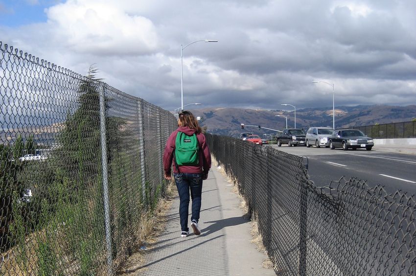
location of the project was Anne Darling Elementary School (see figure 1), situated along an intensely
trafficked arterial roadway that feeds into U.S. Highway 101. At the time of the study, 525 K-5 students
attended the school, many of whom had to navigate decidedly unsafe and unpleasant conditions in
their daily journey from home to school. Figures 2, 3 and 4 illustrate these conditions.
Figure 1. Location of Anne Darling Elementary School and notable Central San José
features
Source: “Safe Routes to School” Community Assessment Report produced by SJSU urban planning graduate students, 2011
M I N E TA T R A N S P O RTAT I O N I N S T I T U T E 2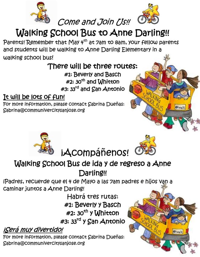
Project 2061   February 2021

 Figure 2. Example of unpleasant pedestrian conditions near Anne Darling Elementary
           School
 Source: Richard Kos

M I N E TA T R A N S P O RTAT I O N I N S T I T U T E                                 3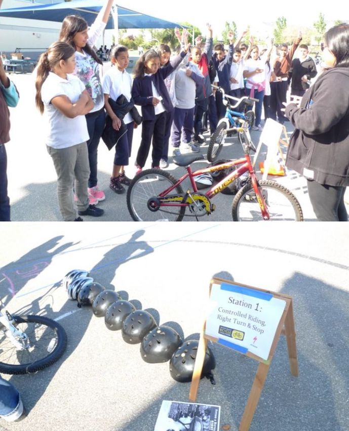
Project 2061   February 2021

 Figure 3. Moe’s Stop, a gas station directly across the street from Anne Darling
           Elementary School. The station’s low prices attract a constant stream of
           drivers, creating hazardous pathways for cyclists and pedestrians.
 Source: Richard Kos

M I N E TA T R A N S P O RTAT I O N I N S T I T U T E                                    4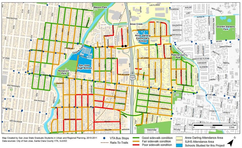
Project 2061    February 2021

 Figure 4. Several wide, speed-encouraging streets connect Anne Darling Elementary
           School to the homes of students. These routes lack safe and dedicated
           pathways for cyclists and pedestrians.
 Source: Richard Kos

 This Safe Routes to Schools project at Anne Darling Elementary School was organized by
 CommUniverCity San José (CUC), a multi-sector partnership, as the three-part name implies,
 between local San José communities, San José State University, and the City of San José. Since
 its inception in 2005, CUC has focused its efforts on the underserved neighborhoods of central San
 José. These diverse communities are home to about 10 percent of the city’s residents; 64 percent of
 the population is Hispanic, and about 45 percent of residents are foreign-born. CommUniverCity’s
 programs impact low-and-moderate income residents living in neighborhoods near the university.
 In these areas, median household income ($56,299) is 58 percent of the median income in the City
 of San José as a whole, and 40 percent of households earn less than $50,000 per year. Nearly 85
 percent of students are eligible for free or reduced-price meals. A significant percentage of K-12
 students in the schools that partner with CUC perform below grade level in English and Math.

 CommUniverCity projects help advance San José State University’s mission “to enrich the lives of
 its students, to transmit knowledge along with the necessary skills for applying it in the service of
 our society, and to expand the base of knowledge through research and scholarship.”

M I N E TA T R A N S P O RTAT I O N I N S T I T U T E                                               5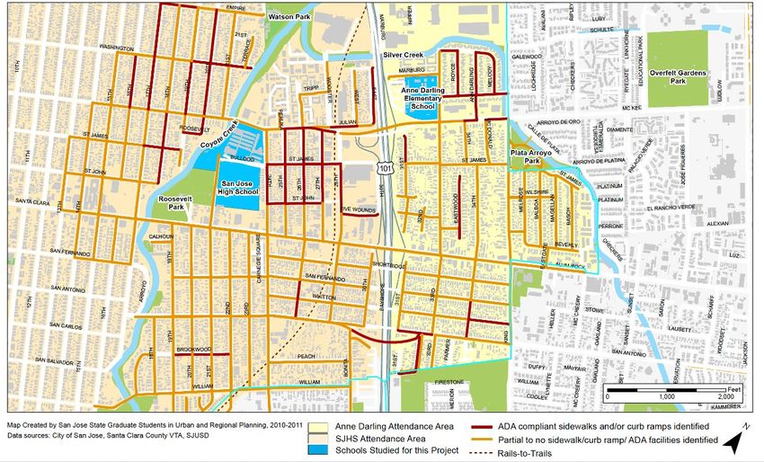
Project 2061    February 2021

 To date, CommUniverCity has engaged 119,721 residents in community-building projects and
 22,830 students have invested 432,352 hours. Together with faculty and staff volunteer time, this
 represents the equivalent of $9.39 million of benefit to local communities.

 Since 2005, CommUniverCity has focused most of its efforts in the Five Wounds Brookwood
 neighborhood – which includes Anne Darling Elementary – where it continues to log many successes
 today. Starting in 2012, CommUniverCity began to play a more prominent role in filling the urban
 planning void caused by the dissolution of California’s Redevelopment Agencies. These agencies,
 a casualty of the Great Recession of the late 2000s, once provided significant funding and staffing
 for San Jose’s Strong Neighborhoods Initiative that supported community improvement projects in
 Five Wounds. San José State’s Urban Planning faculty and students have also been instrumental
 in continuing the positive work started by the defunct Strong Neighborhoods Initiative.

 To guide the Anne Darling Elementary School Safe Routes research, the graduate students
 adopted the Collaborative Neighborhood Planning Model to guide their data collection and
 community engagement efforts. The model includes three phases, described below and in the
 three subsequent sections of this report:

     • Community Assessment: preparation of a comprehensive documentation of historical and
       current conditions in the study area.

     • Community Building: developing trust-based relationships with community leaders to review
       assessment findings and set community-driven priorities for next steps in the planning process.

     • Implementation Bridges: developing short- and long-term solutions for addressing community-
       driven priorities by identifying supportive city departments and people, possible public and
       private funding streams, and anticipated timelines to completion.

 Community Assessment of Walking and Biking Conditions around Anne Darling
 Elementary School

 The “ethos” of the Capstone in Community Planning course – emphasized on the first day of
 class – is Asset-Based Community Development. The ABCD approach shapes planning-based,
 service-learning projects since it places primary emphasis on what is already working well in
 local communities – its assets and internal capacities for change – as characterized by trusted
 individuals, organizations, and webs of mutual support. The ABCD model emphasizes a “bottom-
 up” approach to community planning that capitalizes on community uniqueness and assets rather
 than concentrating exclusively on how outside organizations should “fix” deficits and problems.

 Unlike traditional planning approaches in which urban planners get to know neighborhoods
 primarily through “clinical” desk research, the ABCD model incorporates mixed methods, diverse
 sources of qualitative data, and – most vitally – friendly and welcoming, face-to-face, on-site
 engagement with community members. The model’s primary emphasis on leveraging community
 assets encourages local residents to recognize the power they already possess to mobilize
 and support one another to catalog self-identified neighborhood improvement priorities. From
 this position of empowerment, community leaders can then seek implementation assistance, as
 needed, from outside organizations.

M I N E TA T R A N S P O RTAT I O N I N S T I T U T E                                               6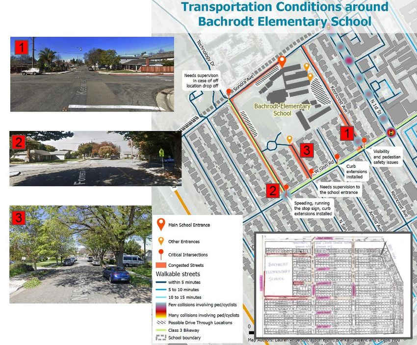
Project 2061       February 2021

 The graduate student team committed to the principles of ABCD when conducting the community
 assessment of the neighborhoods around Anne Darling Elementary School, focusing first on
 listing neighborhood strengths, trusted institutions and people, and cherished places. Notable
 components of the assessment included:

     • careful documentation of demographic data and physical conditions in the study area

     • pinpointing key topical and geographic areas of concern based specifically on the ideas and
       viewpoints shared by parents, students, school administrators, and other community leaders

     • preliminary identification of potential funding sources for community leaders to draw upon
       when implementing Safe Routes to School programs at Anne Darling Elementary School

 Some of the interesting findings from the community assessment are illustrated in figures 5
 through 8, showing maps prepared by the graduate students using Esri’s ArcGIS Geographic
 Information Systems software:

 Figure 5. Community assets around Anne Darling Elementary School
 Source: “Safe Routes to School” Community Assessment Report, SJSU graduate student team, Spring 2011

M I N E TA T R A N S P O RTAT I O N I N S T I T U T E                                                             7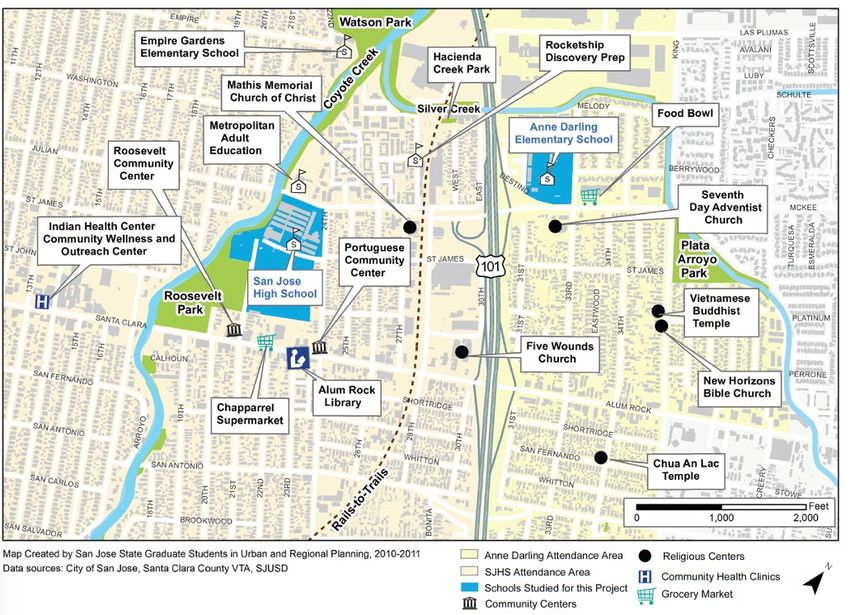
Project 2061       February 2021

 Figure 6. Condition of sidewalks in the project study area
 Source: “Safe Routes to School” Community Assessment Report, SJSU graduate student team, Spring 2011

M I N E TA T R A N S P O RTAT I O N I N S T I T U T E                                                             8
Project 2061       February 2021

 Figure 7.     Systematic assessment of compliance with ADA standards for sidewalks and
               ramps in the study area
 Source: “Safe Routes to School” Community Assessment Report, SJSU graduate student team, Spring 2011

M I N E TA T R A N S P O RTAT I O N I N S T I T U T E                                                             9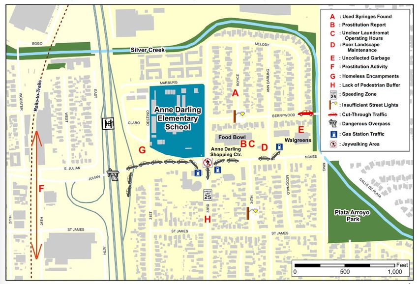
Project 2061       February 2021

 Figure 8. Community member-identified problems around Anne Darling Elementary
           School
 Source: “Safe Routes to School” Community Assessment Report, SJSU graduate student team, Spring 2011

 Community Building at Anne Darling Elementary School

 With the assessment complete, the work turned to three highly successful community-building
 tasks: (1) the establishment of a Parents Task Force to guide the priority-setting process; (2)
 the use of surveys and informational interviews to identify the top mobility-related concerns of
 local residents; and (3) the organization of well-publicized events to highlight community-driven
 Safe Routes to School objectives and solutions. Figures 9 and 10 illustrate highlights of the
 Community Building phase of the Collaborative Neighborhood Planning approach.

M I N E TA T R A N S P O RTAT I O N I N S T I T U T E                                                            10
Project 2061 February 2021
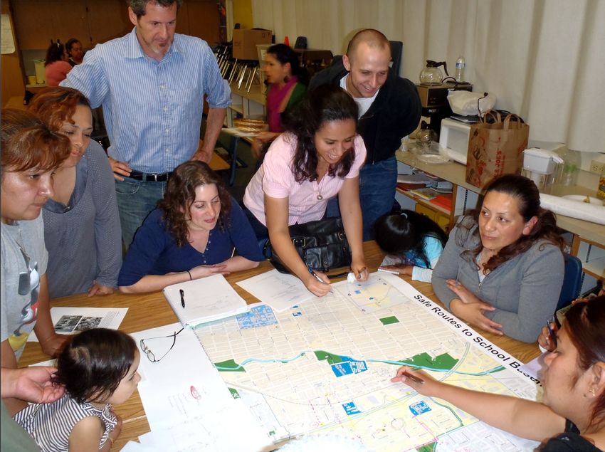
Figure 9. SJSU graduate urban planning students collaborated for months with a Parents
Task Force to document walking and biking conditions in the Anne Darling
Elementary School vicinity.
Photo Source: CommUniverCity
M I N E TA T R A N S P O RTAT I O N I N S T I T U T E 11Project 2061 February 2021
Figure 10. Anne Darling Elementary students – with assistance from their parents –
photographed and wrote movingly and candidly about walking conditions in
the neighborhood from their unique perspectives.
Photo Source: Richard Kos
CommUniverCity staff took the lead in forming the task force of parents – often with their
children in attendance at biweekly meetings – that convened at Anne Darling Elementary
School to have candid discussions about their daily experiences navigating the streets of
the neighborhood. Translation services, activities for the children, and refreshments were
provided by CommUniverCity. Concurrently, the graduate urban planning students designed
and administered a detailed survey to determine how the K-5 students travel between home
and school. In so doing, the graduate students served as “ambassadors” for the Asset-Based
Community Development approach by immediately positioning the residents as the experts in
their community, with the students providing expertise in the form of structured research methods,
systematic data collection, and proper interpretation and summarization of the survey data.
The discussions between school administrators, parents, children, and the graduate urban
planning students ultimately led to two memorable events on May 4, 2011: three morning Walking
School Bus routes and, later in the day, a Bike Rodeo sponsored by the Silicon Valley Bicycle
Coalition. The colorful Walking School Bus “vehicles,” designed by the children of Parents Task
Force members, served as the focal points as about 125 parents and their children walked en
M I N E TA T R A N S P O RTAT I O N I N S T I T U T E 12Project 2061 February 2021 masse to the school, confidently crossing streets normally hostile to pedestrians, as drivers waited for the long procession to pass. The event was clearly invigorating for all who participated – there was a palpable sense, as the children waved happily to the temporarily inconvenienced drivers, that the local neighborhood streets had been reclaimed, even if for only a few minutes. This sense of empowerment was not lost on the parents of this historically marginalized and underserved community. One father, delightedly watching his fourth-grade daughter enjoying her safe walk to school, shared with instructor Rick Kos that “we don’t have anything like ‘planning’ in the country where I’m from”. Later that same morning, the students in 3rd to 5th grade participated in a Bike Rodeo to learn techniques for safe riding, navigate obstacle courses safely, and to understand street signs. A unique aspect of the Rodeo – clearly a favorite for the children – was a “Slow Race”, where cyclists were encouraged to ride as slowly as possible in order to win, as a way to illustrate the benefits of slow, focused, and steady riding. Figures 11 through 14 capture the spirit of the day’s activities. M I N E TA T R A N S P O RTAT I O N I N S T I T U T E 13
Project 2061   February 2021

 Figure 11. Promotion of the three Walking School Bus routes
 Source: CommUniverCity

M I N E TA T R A N S P O RTAT I O N I N S T I T U T E                                  14
Project 2061   February 2021

 Figure 12. The Walking School Bus event was an unqualified success and a joyful
            experience for local parents and children as they approached Anne Darling
            Elementary School, temporarily reclaiming streets normally hostile to
            pedestrians and bicyclists.

M I N E TA T R A N S P O RTAT I O N I N S T I T U T E                                   15
Project 2061 February 2021
Figure 13. The Walking School Bus parents and children confidently navigate the heavily
traveled streets in the vicinity of Anne Darling Elementary School.
M I N E TA T R A N S P O RTAT I O N I N S T I T U T E 16Project 2061 February 2021 Figure 14. Scenes from the Bike Rodeo at Anne Darling Elementary School Photo source: Richard Kos M I N E TA T R A N S P O RTAT I O N I N S T I T U T E 17
Project 2061    February 2021

 Immediately following the day’s events, the graduate student team administered a survey to the
 participating Anne Darling Elementary students to see if the activities changed their views of
 walking and biking to school. The results were compared to the pre-event survey findings, and
 a number of encouraging results were found. For example, the charts in figure 15 reflect data on
 helmet use. The pre-survey results (on the left) reflect responses to the question “how often do
 you wear your helmet while biking?” (scores range from 5 to 1, with 5 as “always” and 1 as “rarely
 or never”). Following the Bike Rodeo event, which consistently emphasized the importance of
 wearing helmets, students were asked “how likely will you use your helmet when you ride your
 bike?” The chart on the right reflects somewhat of a mirror image of the pre-survey results.

 Figure 15. Pre- and post-safety event survey findings to questions pertaining to helmet
            usage.
 Source: CommUniverCity

 Other survey findings were equally as encouraging. The left chart in figure 16 shows the results
 of the question “how likely are you to ride your bike to school?” while the chart on the right shows
 the results of the same question, asked after the May 4 events. Again, “5” means “always” and
 “1” means “rarely or never.”

 Figure 16. Pre- and post-safety event survey findings to “how likely are you to ride your
            bike to school?”
 Source: CommUniverCity

M I N E TA T R A N S P O RTAT I O N I N S T I T U T E                                             18
Project 2061 February 2021 Developing Implementation Bridges to Link Community-Driven Priorities with Supportive Programs and Funding Sources After community assessment and community-building efforts are completed, the final phase of the Collaborative Neighborhood Planning model is the development of “implementation bridges”, charts that link community-identified priorities to recommended solutions. An example of such a chart, prepared by the graduate student team, is illustrated in figure 17; this one is focused on engineering- related interventions. Each of the charts centered on one of the “five E’s” of Safe Routes to Schools planning that were in place in 2011: education, enforcement, encouragement, engineering, and evaluation. One additional “E,” equity, was added in later years – and one “E” was replaced, as explained in the final section of this report. Figure 18 reflects the students’ efforts to illustrate possible flows of funding to Anne Darling Elementary School to support Safe Routes improvements. M I N E TA T R A N S P O RTAT I O N I N S T I T U T E 19
Project 2061       February 2021

 Figure 17. Example of “implementation bridges” to advance community-identified
            priorities on streets around Anne Darling Elementary School
 Source: “Safe Routes to School” Community Assessment Report, SJSU graduate student team, Spring 2011

M I N E TA T R A N S P O RTAT I O N I N S T I T U T E                                                            20
Project 2061 February 2021
Figure 18. A notable outcome of the graduate students’ research was this flowchart to
help school and community leaders visualize the various pathways through
which Safe Routes to School funding might make their way to Anne Darling
Elementary School.
Source: “Safe Routes to School” Community Assessment Report, SJSU graduate student team, Spring 2011
Within a year of completing the project at Anne Darling Elementary, the City of San José
leveraged the student-produced maps and community-identified priorities to secure Community
Development Block Grant (CDBG) funds. $99,000 was allocated to install three flashing beacons
and two median islands to narrow crossing distances along local streets, and $50,000 was
destined for nearby San José High School to install embossed crosswalks and wheelchair ramps.
GIS Mapping and Analysis to Support the City of San José’s Walk n’ Roll Program
Nearly a decade after these successes at Anne Darling Elementary School, SJSU’s urban
planning graduate students were invited to take part in another Safe Routes to Schools planning
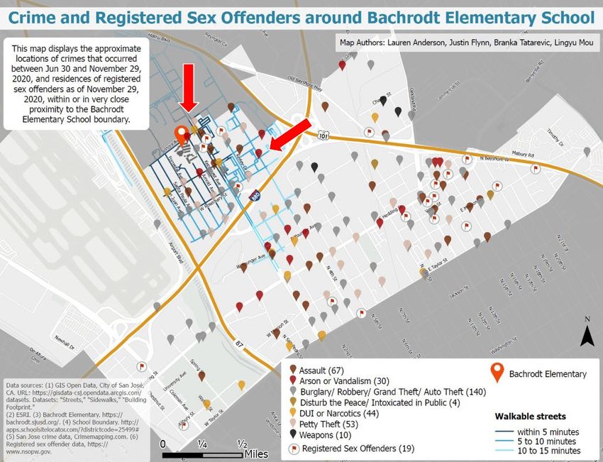
M I N E TA T R A N S P O RTAT I O N I N S T I T U T E 21Project 2061 February 2021 effort. The City of San José’s Walk n’ Roll program works with the Vision Zero initiative and is modeled after the federal Safe Routes to School program, which aims to promote walking and biking among K – 12 students. Vision Zero is a strategy to eliminate all traffic fatalities and severe injuries, while increasing safe, healthy, equitable mobility for all. First implemented in Sweden in the 1990s, Vision Zero has proved successful across Europe — and now it is gaining momentum in major American cities.1 Ann Jasper, the Walk n’ Roll program manager, notes that more active transportation among students means better physical health, better focus while in the classroom, calmer traffic, and better air quality.2 The program began in 2012 and currently serves almost 60 elementary and middle schools in twelve of San José’s school districts. The ultimate goal is to support Walk n’ Roll activities at all 250 public schools in San José. The program’s proponents know that in order to increase walking and biking among students, there needs to be access to infrastructure that accommodates active transportation – including sidewalks, bike lanes, and spaces that minimize conflict between cars, pedestrians and bicyclists. Disadvantaged communities historically do not feature walk/bike-friendly infrastructure and securing funding to address this inequity is often met through state and federal grants. Of the current “Six E’s” of Safe Routes to School planning, the engineering “E,” which refers to building infrastructure that accommodates active transportation, is funded largely through state and federal grants. Ann Jasper requested that SJSU graduate students in the Advanced Geographic Information Systems course prepare detailed maps and demographic data that would be critical to successful grant applications. She also invited the students to join in conversations with school staff, parents, and students to better understand physical conditions around four schools selected for this project: Bachrodt Elementary, Parkview Elementary, Sierramont Middle, and Valle Vista Elementary. Since this project was conducted in late 2020 during the COVID-19 pandemic, these conversations took place remotely and relied heavily on virtual meetings that used Google Street View to “walk” down the local streets. Examples of the graduate students’ final work is illustrated in figures 19 and 20 for Bachrodt Elementary School. The first shows the result of careful documentation during meetings with the school principal and parents. The hand-labeled map at the lower right of figure 19 shows the “talking points” sheet that the school community had been using to document unsafe areas for walking and cycling, highlighted in red. The remainder of the map shows how the students translated these findings into a clear depiction of physical conditions supplemented with photos of the particularly problematic areas. Figure 20 shows how the students broadened their analysis to look at Bachrodt Elementary in a larger spatial context. On a single sheet they integrated a great deal of valuable information for the Walk n’ Roll team to consider when preparing grant applications: walking distances from the school, in blue (measured using Esri’s Network Analyst GIS software), the locations of crime reports and registered sex offenders, and major highways that divide the school’s attendance area into three rigidly separated portions. 1 “What is Vision Zero?” Vision Zero Network. www.visionzeronetwork.org/about/what-is-vision-zero/ (accessed January 31, 2021). 2 Ann Jasper, City of San José Walk n’ Roll Program Manager, in “Project Objectives” RFP proposal to the SJSU URBP-279 graduate student team, August 2020. M I N E TA T R A N S P O RTAT I O N I N S T I T U T E 22
Project 2061   February 2021

 Figure 19. Depiction of local transportation conditions, including photographs
            of problematic intersections, parent-provided “hot spot” maps, and a
            visualization of physical conditions around Bachrodt Elementary School.

M I N E TA T R A N S P O RTAT I O N I N S T I T U T E                                 23
Project 2061 February 2021
Figure 20. Responding to input from parents and school leaders, the graduate students
prepared maps of recent crime locations and addresses of registered sex
offenders.
Responding to Ann Jasper’s need for detailed demographic data to support Safe Routes grant
applications, the graduate students prepared a series of infographics using Esri’s Community Analyst
web mapping application to capture attributes such as educational attainment and income for various
portions of the attendance area for the four schools; an example is shown in figure 21.
M I N E TA T R A N S P O RTAT I O N I N S T I T U T E 24Project 2061 February 2021
Figure 21. Demographic summaries in infographic format for areas surrounding Bachrodt
Elementary School.
Another of the students’ final products was a series of posters, tailored to each of the four
schools, that is intended to be used by the school community to centralize discussions about
walking and biking conditions in the area. An example is shown in figure 22.
M I N E TA T R A N S P O RTAT I O N I N S T I T U T E 25Project 2061 February 2021
Figure 22. Detailed, yet “kid and parent accessible” poster of Bachrodt Elementary School
and surrounding street conditions, designed to focus future discussions about
Safe Routes planning.
M I N E TA T R A N S P O RTAT I O N I N S T I T U T E 26Project 2061 February 2021
The three deliverables illustrated above (detailed physical conditions maps, demographic data
summaries, and posters to focus school community discussions), were produced for all four
schools assigned to the students by the Walk n’ Roll staff. After delivery of the final products, Ann
Jasper shared that, “That is the most thorough analysis of active transportation routes I’ve seen!
I love how [the students] included details about socioeconomic factors - it’s critical to figuring out
not only the safety, but personal security issues related to walking and biking. I feel that I can
confidently present these maps to our Vision Zero team as well as the four schools.”3
Factors Shaping Future Safe Routes to Schools Planning
Many discussions of Safe Routes to Schools planning mention the “Six E’s” that shape these
efforts: engagement, engineering, encouragement, education, evaluation, enforcement and,
added in recent years, equity. During their research and interactions with the Anne Darling
Elementary School community, the faculty and students remained cognizant of this long-
established categorization scheme, though they found other frameworks more suitable to shape
their community engagement methods, specifically the Asset-Based Community Development
philosophy and the structured Collaborative Planning Model. These approaches were less
relevant for the Walk n’ Roll project since COVID-19 curtailed almost all opportunities to directly
engage with community leaders on a sustained basis.
As mobility-focused projects such as Safe Routes move forward, it is important to bear in mind
that the national non-profit Safe Routes Partnership made an important change to the “E’s” in the
middle of 2020, inspired by the tumultuous events of that year: they dropped “enforcement” and
replaced it with “engagement”. They explained their decision this way:
As part of the addition of Equity several years ago, the Safe Routes Partnership
refocused the Enforcement E on community approaches to safety, understanding the
deep issues that exist in many communities with law enforcement. While we have
shifted our communications and guidance away from promoting police as a critical part
of traffic safety initiatives, helped highlight the inequitable impacts of law enforcement
on people of color, and promoted traffic and public safety strategies that do not involve
police, we now know that that is not enough. Through an examination of what is
within our organization’s ability to change, and more importantly listening to our staff,
organizational partners, and partners in the field, we know that approach is no longer
sufficient. Being an anti-racist organization is a journey, not a destination, and we are
committed to continuing to take clear and decisive steps to undo the systems that
prevent Black people, indigenous people, and people of color from moving around the
world safely, healthily, joyfully, and in their full expression of self.4
This important change will shape the service-learning work of future graduate urban planning
students at San José State University and will undoubtedly lead to rich conversations amongst
our highly diverse and equity-minded aspiring professional planners.
3
Email from Ann Jasper to Richard Kos and graduate student team, December 4, 2020.
4
“Dropping Enforcement from the Safe Routes to School 6 E’s Framework”, https://www.saferoutespartnership.org/
blog/dropping-enforcement-safe-routes-school-6-e%E2%80%99s-framework (accessed January 4, 2021).
M I N E TA T R A N S P O RTAT I O N I N S T I T U T E 27Project 2061 February 2021
Sparking Longstanding Student Engagement in Community Planning
The work of the urban planning graduate students in the service-learning projects described in this
report yielded a number of direct benefits that carried into their subsequent internships and careers:
• Exposure to real-world planning concepts and principles
• Involvement in the public participation process
• Skill development – integrating theory with practice
• Direct and regular feedback from faculty, community leaders, and professional planners
• Connections to professional planners, elected officials, and local community leaders
In order to document these benefits, CommUniverCity collects student reflections on the final day
of service-learning courses to see how the completed project might influence their career paths.
Recent representative responses include:5
“The challenges and motivations experienced during this community engagement have
encouraged me to pursue new opportunities of community engagement activities in future.”
“Being able to relate and understand the implications of planning policy decisions first
hand and from the community has provided me with a perspective that I will take with me
in future endeavors.”
Quite a few CommUniverCity-affiliated planning students at San José State University secure
internships and full-time positions working with the City of San José and partner organizations.
Some alumni continue to collaborate with CommUniverCity on spin-off projects, and they tend
to carry the “community first” premise of engagement with them, creating a “virtuous cycle.” One
such alumnus, Nick Danty, now a Transportation Planner with the City of San José, explained
the impact of service-learning projects on his career path this way:6
There were a few very important takeaways from the URBP 295 course that I have
used in my professional life. First, the asset-based approach (compared to a needs-
based approach) used throughout the course completely changed the way I looked at
transportation and land use planning. Before taking the class, I was very quick to judge
cities by their deficiencies instead of praising them for their strengths. This changed
during my 295 class, where we focused on identifying all the positive elements of [a local
neighborhood] by interviewing residents, researching the area’s history, and visiting the
neighborhood for informal walks and, eventually, observational field work. Now in my
current role, I have a much easier time gaining public support for my roadway projects by
pointing out how they complement the neighborhood’s existing positive traits, instead of
how they will fix a horrible problem created by someone else.
5
“Fifteen Years Creating Great Neighborhoods for Everyone” 2019-2020 CommUniverCity Annual Report. http://cucsj.
org/wp-content/uploads/2020/10/CUCSJ-Annual-Report-19-20-5_FacingPages.pdf (accessed January 10, 2021).
6
Used with permission from Nick Danty granted via email to Richard Kos on January 10, 2021.
M I N E TA T R A N S P O RTAT I O N I N S T I T U T E 28Project 2061 February 2021
Nick went on to note additional benefits of his community engagement work at San José State
University:
This class is probably the closest any urban planning student will come to experiencing a
real-world planning effort prior to their first job. The safety fence created by the classroom
is lowered, and you and your team have the opportunity to engage in meaningful decision
making, conflict resolution, customer service, stakeholder communication, and project
management. I am a firm believer in the value of data analytics, GIS, and graphic design
in community planning, but in the end these are simply tools that must be supplemented
with sharp interpersonal skills and concise communication.
Closing Thoughts
One of the primary missions of the California State University system, of which San José State
is a part, is to “prepare significant numbers of educated, responsible people to contribute to
California’s schools, economy, culture, and future.” The Department of Urban and Regional
Planning puts this mission into practice through service-learning projects that engage students
directly in the affairs of residents in the City of San José.
The two Safe Routes to Schools projects highlighted in this report demonstrate how the power of
multi-sector partnerships, coupled with the available time, motivations, and idealism of university
students, can have long-lasting impacts for a major U.S. city that is in the process of redressing
safety problems wrought by decades of auto-centric street designs. Perhaps this report may
encourage similar efforts across the nation in communities that are fortunate to have a nearby
university with faculty and students committed to the welfare of their host cities.
M I N E TA T R A N S P O RTAT I O N I N S T I T U T E 29Project 2061 February 2021
Acknowledgements
I wish to thank MTI staff, including Executive Director Karen Philbrick, PhD; Deputy Executive
Director Hilary Nixon, PhD; Communications & Operations Manager Irma Garcia, for giving me
this opportunity to boast about the inspiring work of my graduate students. Additional thanks
go to the author’s dedicated urban planning graduate students in the spring 2011 and fall 2020
semesters, including Branka Tatarevic, Justin Flynn, and Sue-Ellen Katz Atkinson, all of whom
participated in an MTI-sponsored webinar related to this report on February 16, 2021. I also
appreciate Lisa Rose for her wonderfully detailed copyediting for this report. Finally, a tip of the
hat to my friends and kindred spirits at CommUniverCity San José including Executive Director
Katherine Cushing and Community Director Imelda Rodriguez.
About the Author
Richard M. Kos, AICP, is a certified Urban Planner;
Lecturer, Graduate Advisor, and Practitioner
in Residence in the Department of Urban and
Regional Planning at San José State University.
Richard has collaborated with over 200 graduate
students in service-learning projects since starting
MTI is a University Transportation Center sponsored by
with the department in 2007. the U.S. Department of Transportation’s Office of
the Assistant Secretary for Research and Technology
This report can be accessed at and by Caltrans. The Institute is located within San José
transweb.sjsu.edu/research/2061 State University’s Lucas Graduate School of Business.
M I N E TA T R A N S P O RTAT I O N I N S T I T U T E transweb.sjsu.eduYou can also read