Scott Air Force Base Bicycle & Pedestrian - Commuter Plan 2013 Produced For By With Funding Support From
←
→
Page content transcription
If your browser does not render page correctly, please read the page content below
Scott Air Force Base
Bicycle & Pedestrian
Commuter Plan 2013
          Produced For

               By

    With Funding Support From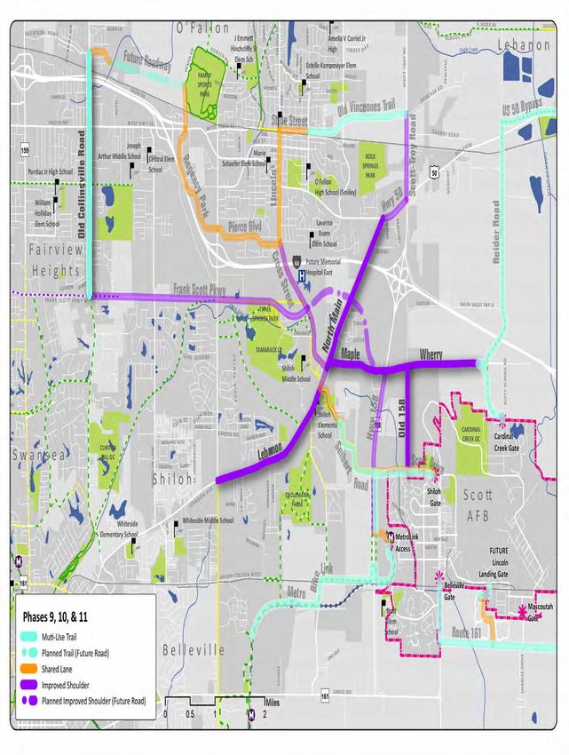
Table of Contents
Introduction & Existing Conditions................................................................5
    Purpose
    Physical Fitness
    Data Collection
    Open House #1
    Stakeholder Meetings
    Open House #2
    Existing Conditions Map
Plan Principles.............................................................................................17
    Complete Streets
    Recommended Facility Types
    Facility Type Construction Estimates
    Potential Funding Sources
    Pedal Past the Pump: Shift Your Commute
    Plan Map
Implementation...........................................................................................29
    Prioritization
    Intersections & Design Guidelines
    Education
    Enforcement
    Encouragement
    Route Signs & Wayfinding
    Marketing & Recognition
Appendix.....................................................................................................46

Acknowledgments
This plan was produced by HeartLands Conservancy with the financial assistance of the
Illinois Department of Transportation through the State Research & Planning Grants
program and the cities of Mascoutah, O’Fallon, and Shiloh. Assistance also provided by
Trailnet and James Pona of James Pona & Associates.
The content and completion of this plan would not have been possible without the
support and assistance of the following:
The staff and elected officials of Scott Air Force Base, the Cities of O’Fallon, Mascoutah,
and the Village of Shiloh :
    • Daniel Schloesser, Planner 375 CES/CEAO
    • Todd Bjerkaas, O’Fallon Senior City Planner
    • Elliot Liebson, Mascoutah Economic Development
    • Norm Etling, Village of Shiloh Engineer
Citizen Advisory Committee
Horner & Shifrin, Inc. Engineers
The “Shift Your Commute” Logo and Website are the Property of Trailnet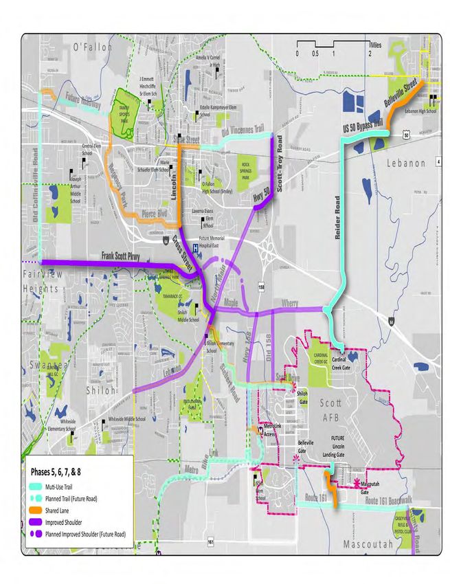
Executive Summary
          This document represents the Shift Your Commute: Scott Air Force Base Bicycle &
          Pedestrian Commuter Study. The objective of this plan is to provide a conceptual
          framework guiding future on- and off-street bicycle and pedestrian facilities along major
          corridors to Scott AFB, with the overarching goal to transform SAFB and the surrounding
          communities of Mascoutah, O’Fallon, & Shiloh into more bicycle-commuter and pedestrian-
          commuter friendly communities.

          This planning process began in Fall 2012 and included two rounds of public open houses, or
          a total of six open houses. Multiple surveys were completed by SAFB employees, residents,
          and residents of the surrounding communities and comments were solicited and received
          at every juncture. The vast majority of residents who participated in the survey and open
          houses were in favor of helping create more bicycle and pedestrian routes to and from Scott
          AFB. There is a core group of citizens already commuting by bike or foot and more who
          would be interested in leaving the car at home if the routes to the base were made more
          safe for all forms of travel. While this is a long-term plan meant to take up to 20 years to
          implement, it provides the blueprint, in the form of phases, for constant progress. As more
          phases of this plan are implemented, the more positive impacts will be realized.

          It is our hope that this plan, once implemented, will enable commuters of all skills, interests
          and needs to get to Scott Air Force Base from the surrounding communities.

Disclaimer: The work that provided the basis of this publication was supported by funding under an award with the U.S. Department
 of Housing and Urban Development through East-West Gateway Council of Governments. The substance and findings of the work
 are dedicated to the public. The author and publisher are solely responsible for the accuracy of the statements and interpretations
  contained in this publication. Such interpretations do not necessarily reflect the views of the Government or East-West Gateway.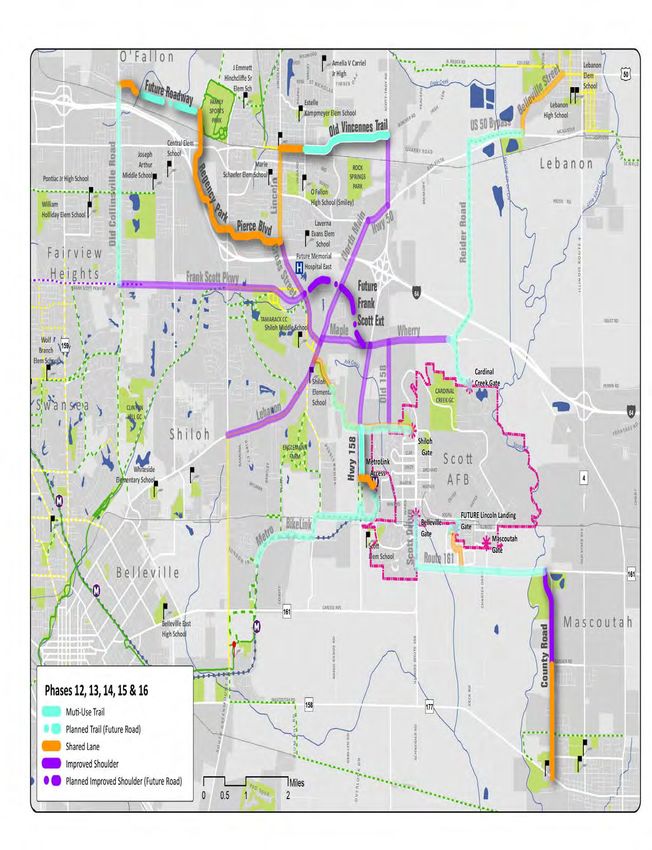
Introduction &
Existing Conditions
Introduction & Existing Conditions

                                         Purpose
                                         Scott Air Force Base, in partnership with the Cities of O’Fallon, Mascoutah and Shiloh commissioned
                                         this study to investigate and determine the most suitable and appropriate routes for employees
                                         of the air force base to commute to work via bicycle or foot. The base is anticipating a growing
                                         demand for parking from commuting employees and is interested in promoting alternative methods
                                         of transportation to and from the base. As the largest employer in Illinois, south of Springfield, the
                                         surrounding communities of O’Fallon, Mascoutah and Shiloh are invested in the success of the base,
                                         the long-term viability of the regional transportation infrastructure, and the health and livability
                                         options for their residents.

                                         External to the specific needs of the base, there are factors inspiring people to think outside the car for
                                         their transportation needs, such as personal health and rising fuel costs. There are currently a number
                                         of active bicycle commuters who work at the base and this plan aims to increase the safety of the
                                         roadways they currently use, as well as to inspire and encourage additional alternative transportation
                                         commuters. The successful implementation of this plan will involve both “brick and mortar” changes
                                         to the surrounding roadway and trail system and a comprehensive education and encouragement
                                         campaign on base.

                                         The Shift Your Commute (SYC) Scott Air Force Base (SAFB) Plan is a comprehensive, long-range analysis
                                         that outlines a blueprint for a connected system of facilities, including a phased implementation
                                         strategy based on citizen- and data-driven priorities. The piece-by-piece approach to the construction
                                         of this network will enable each City and the base to be proactive in searching for grant funding, along
                                         with leveraging available resources.

                                         About Scott Air Force Base
                                         Located in St. Clair County, Illinois, approximately 20 miles east of the City of St. Louis, Missouri, Scott
                                         AFB remains one of the oldest, continuous service U.S. Air Force installations. Occupying approximately
                                         3,000 acres, Scott AFB is home to the United States Transportation Command (USTRANSCOM), Air
                                         Mobility Command (AMC), Military Surface Deployment and Distribution Command (SDDC), and
                                         provides Headquarters for the 18th Air Force, the 932nd Air Force Reserve Command and the 126th Air
                                         Refueling Wing of the Illinois National Guard. The 375th Air Mobility Wing is the host unit at Scott AFB.

                                         Since 1917 Scott Field, re-designated Scott Air Forces Base in
                                         1948, has had many assignments including; medical airlift,
                                         technical training, lighter-than-air balloon/airship development,
                                         General Headquarters, Radio School, Air Mobility Command, air
                                         refueling, and others. Along with each major assignment came
                                         additions and renovations to buildings, roads, airfields, and
                                         railroads. Development on the base expanded more than four
                                         times and now encompasses more than 3,500 acres.

                                         The base is named after Corporal Frank S. Scott, the first
                                         enlisted person to be killed in an aviation crash. Its airfield
                                         is also used by civilian aircraft, with civilian operations at
                                         the base referring to the facility as MidAmerica St. Louis
                                         Airport. MidAmerica has operated as a Joint Use Airport since
                                         November 1997. The residential part of the base is a census-
                                         designated place; the population was 3,612 at the 2010 census.
                                                                                       Corporal Frank S. Scott

                                     6
Introduction & Existing Conditions
Every United States military transportation operation is controlled and monitored at Scott AFB, from
deploying troops and materials for national defense to transporting the President of the United States.

There are nearly 1,600 family homes, 396 dormitories, 350 visitor quarters, 10 DV quarters, and 55
temporary lodging facilities on base.

Scott AFB is also home to the eastern terminus of the St. Louis MetroLink light rail line - the Shiloh–
Scott station links Scott Air Force Base with Lambert International Airport on MetroLink’s Red Line.

Access to the Base
Access to the Air Force Base is strictly controlled and monitored. There are various gates, each location
has regulated access times:
 • Belleville Gate (County Road 1845/Scott Drive): 4:30 a.m. - 11:30 p.m.; 7 days/week
 • MetroLink Pedestrian Gate: 6:30 a.m. - 4:30 p.m.
 • Shiloh Gate (Seibert Road): 24 hours, 7 days/week
 • Cardinal Creek Gate (Pryor Drive): 6 a.m. - 8 a.m. and 3 p.m. - 5 p.m.; Monday – Friday
 • Mascoutah Gate/Commercial Vehicle Inspection Station (Florida Street and Charles Lane): 6 a.m. - 4
   p.m.; Monday – Friday
 • Scott School (K-5) Gate (Paul Revere Drive): (Active School Days Only) 6:30 a.m. - 8:30 a.m. and 2:30
   p.m. - 4 p.m.; Monday, Thursday and Friday. 6:30 a.m. - 8:30 a.m. and 2:30 p.m. - 4:40 p.m.; Tuesday
   and Wednesday. Note: The Scott School Gate is only authorized for pass holding parents dropping off
   students at Scott Elementary or the Youth Center; all other traffic will be denied access.
 • The gate to the school on Patriots Drive is open during school days only, from: 6:30 - 8:30 am and
   2:30 - 4:00 pm Monday, Thursday, Friday, 2:30 - 4:40 pm Tuesday and Wednesday for Tutoring. The
   Pedestrian gate is open until 4:30 pm. Entry into Patriots Landing through the school access road (off
   Section Line Road) is not authorized at any time.

                                                                                                            7
Introduction & Existing Conditions

                                         Existing Plans, Policies & Studies - SAFB
                                         Since 2010, the base has conducted three planning/policy efforts that guide the recommendations in
                                         this plan document. These efforts, (1) the
                                         2010 SAFB Bike Racks Plan, (2) the 2011
                                         Carpool Parking Policy, and (3) the 2012
                                         SAFB Traffic Study, are summarized below.

                                         2010 SAFB Bike Racks Plan
                                         Three styles of bike racks currently exist
                                         on base: ribbon or wave, traditional pull
                                         in rack, & bollard. The plan shows existing
                                         locations, proposed new locations and
                                         areas for additional bike parking spots.

                                         The plan recommend 26 new and
                                         additional locations: 30 new bike racks at
                                         9 bikes per rack equals 270 parking spots.
                                         Costs for 26 Additional Bike Racks (prices                   Bldg. 1800 (Dining Hall) Ribbon Style
                                         based on purchase of 25 or more):
                                          • Ribbon Style*: $186 each x 30 = $5,580
                                          • Traditional Style: $244 each x 30 = $7, 320
                                          • Bollard Style*: $122 for 2 bikes or $122 x 135 = $16, 470
                                         (*Ribbon and bollard styles require concrete pad for mounting)
                                         The preferred style is the ribbon rack securely bolted to concrete. They fit with the base architecture
                                         and can be purchased painted or plastic coated to match base color scheme.

                                         2013 Update: All sites identified in this plan have received bicycle racks.

                                         2011 Carpool Parking Policy
                                         Application: This policy applies to all work centers on Scott AFB with an anticipated workforce of 50 or
                                         more personnel in the work center (at the same time).

                                         Purpose: To incentivize carpooling in order to reduce fuel consumption, decrease employee fuel costs,
                                         and mitigate parking congestion.

                                         Current Situation: Some large administrative buildings with high demand parking lots already have
                                         carpool parking by permit. These carpool spaces are
                                         typically located close to facility entrance as an incentive
                                         to carpooling. Carpool parking is controlled by permit
                                         through the building facility managers who enforce
                                         restricted parking around their buildings.

                                         Eligible Facilities: The following facilities are determined
                                         to have a work force of 50 or greater and therefore
                                         garner designated carpool parking in accordance w/this
                                         policy and beyond current permitted parking: Buildings:
                                         3, 4, 10, 40, 61, 433, 450, 505, 528, 700, 859, 861, 1515,
                                         1521, 1530, 1533, 1534, 1575, 1600, 1650, 1700, 1900,
                                         1910, 1911, 1930, 1948, 1961, 3189, 3600, 3650, 3652,
                                         and 4001.

                                     8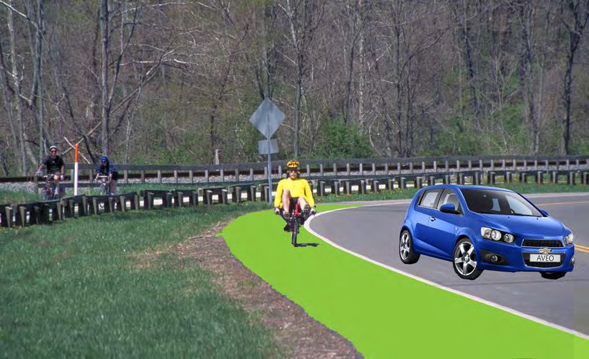
Introduction & Existing Conditions
                                                                                        “To qualify
Procedures for designating parking space: Facility managers for the                   for a carpool
buildings listed shall identify at least one parking space to designate
as carpool parking. Carpool parking spaces shall be located as close               parking space a
as practical to the main entrance. Facility managers will submit a Civil
Engineering Work Request (AF Form 332) including a simple map showing
                                                                                   vehicle must be
the location for the designated spot(s). The 375th Civil Engineer Squadron        transporting 2 or
will validate the location and install signs. The parking sign will be a
standard carpool sign. Facility managers may request more than one spot          more employees.”
at any time if there is sufficient demand.                                           - SAFB Carpool
                                                                                Parking Policy (2011)
Regulation: To qualify for a carpool parking space a vehicle must be
transporting 2 or more employees. To register the vehicle for a carpool parking space contact the
facility manager. All parking is coordinated and enforced through the facility manager. Designated
carpool parking spaces will be available on a first-come, first-serve basis. If vacated during the day (such
as lunch time) another carpooling vehicle can use that space. In the event a carpool vehicle driver
works at a facility with less than 50 employees, and parking at their facility is typically at maximum
capacity. That driver may request a carpool space through their facility manager.

Carpool/Mass Transit References: Anyone interested in forming a carpool can contact Ride Finders,
a web based service at ridefinders@mct.org or phone number (800) 847-7433. RideFinders matches
carpooling individuals with other interested individuals and even provides vans for “vanpooling”. Scott
AFB also boasts an excellent mass transit system with the Metro Link train station located along the
western perimeter of the base. Metro buses provide shuttle services to the East and West sides of
the base. The Saint Clair County Transit District Metro Link schedule and other transportation related
information can be found at: http://www.scctd.org

2013 Update: Feedback from the Citizen’s Advisory Committee (see page 11) reported the Carpool
Policy to pertain ONLY to vehicles with three or more employees. This confusion should be clarified
base-wide to encourage more carpooling. In addition, as opposed to special parking spaces, we
recommend carpool cars be granted their own lane through the main gate of the base for “check-
in” - feedback indicates this would be a better motivator for increasing the quantity and frequency of
carpooling.

2012 SAFB Traffic Study
The purpose of the study conducted in 2010 was to assess existing conditions and to identify short‐
term and long‐term transportation needs to safely provide for existing and future transportation
demands. Primary areas of focus include entry control facilities (ECFs), key intersections and pedestrian
accommodations.

The study documents all transportation related issues on Scott Air Force Base, provides solutions, cost
estimates and priority for an implementation schedule. The document focuses heavily on the specific
designs of the entry gates so they may meet the Department of Defense engineering standards. The
plan also addresses safe crosswalk design and indicates several places where upgrades and changes
need to be made on base. The plan neglects to address pedestrian and/bicycle accommodations at the
entry gates. The study also includes a survey in which 43% of people answered they regularly use the
Shiloh gate, followed by 30.6% in the Belleville Gate. However, if the Cardinal Creek gate was improved
use would increase from the current 22.2% to 30%.

                                                                                                               9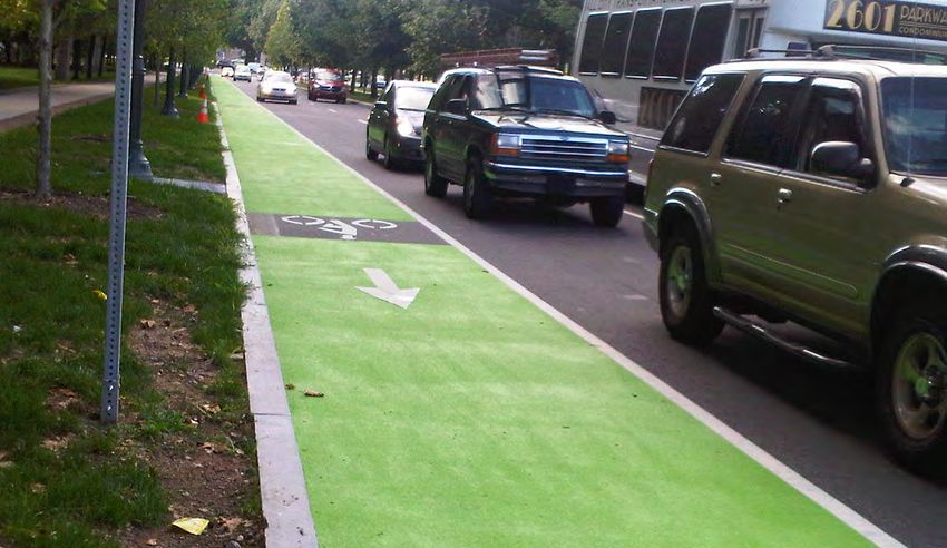
Introduction & Existing Conditions

                                          Physical Fitness
                                          Increasing opportunities and options for active transportation creates healthier communities.
                                          According to the Centers for Disease Control, “People who are physically active live longer and have a
                                          lower risk for heart disease, stroke, type 2 diabetes, depression, and some cancers. Improving spaces
                                          and having safe places to walk can help more people become physically active.” Less than half of all
                                          adults get the recommended amount of physical activity, and walking requires no special equipment or
                                          training.

                                          County Health Rankings
                                          The University of Wisconsin’s Population Health Institute has analyzed a series of factors to produce
                                          a ranking for counties of Illinois in two categories: health outcomes (premature death, overall
                                          morbidity,etc.) and health factors (obesity, smoking, etc.). The analysis is intended to produce a picture
                                          of overall community health based on factors like quality of health care, individual behavior, education,
                                          employment and environmental factors. The goal is to capture a
                                          picture of both physical and mental health.

                                          The results were published in the County Health Rankings:                    St. Clair County is
                                          Mobilizing Action Toward Community Health – Illinois 2012 report
                                          (countyhealthrankings.org). St. Clair County is ranked 94 out of 102
                                          counties (1 being the healthiest and 102 being the least healthy            94th out of 102
                                          county in Illinois) for Health Outcomes and 100 out of 102 for
                                          Health Factors. These poor results indicate that citizens in this
                                          region would benefit greatly from access to a high-quality system           Counties in Illinois
                                          for active transportation and recreation.

                                          Air Force Policy
                                          The Air Force Fitness Program goal is to motivate Airmen to participate in a year-round physical
                                          conditioning program that emphasizes total fitness, to include proper aerobic conditioning, strength
                                          and flexibility training, and healthy eating. Health benefits from an active lifestyle will increase
                                          productivity, optimize health, and decrease absenteeism while maintaining a higher level of readiness.
                                          The new physical fitness standards, enacted
                                          by the Air Force in 2010, represent the most
                                          strenuous in over a decade. The changes were
                                          made to promote a fitness-based culture that
                                          enhances the mission readiness of Airmen.

                                          Specifically at Scott AFB, The Health and Wellness
                                          Center (HAWC) is a place where the entire Scott
                                          AFB Community can come and find a highly
                                          qualified staff ready and willing to assist/support
                                          all personnel and beneficiaries in achieving
                                          healthier lifestyles. The HAWC supports the
                                          Commander in cultivating a fit and ready force,
                                          optimizing performance with an emphasis on
                                          prevention of illness and injury.

                                     10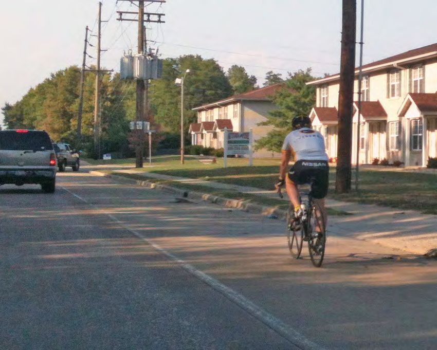
Introduction & Existing Conditions
Bike Commuting Better Than The Gym? (peopleforbikes.org)
Biking for transportation appears more helpful in losing weight and promoting health than working out
at the gym. According to Australian epidemiologist Takemi Sugiyama, lead author of a recent study in
the American Journal of Preventive Medicine, “Commuting is a relevant health behavior even for those
who are sufficiently active in their leisure time.” Analyzing the research, The Health Behavior News
Service notes, “It may be more realistic to accumulate physical activity through active transport than
adding exercise to weekly leisure-time routines.”

The four-year study of 822 adults found that people commuting to work by car gained more weight
on average, even if they engaged in regular exercise, than people who did not commute by car. The
authors of the study recommend creating more opportunities for everyone to walk or bike to work.

An earlier study by researchers at the University of Sydney School of Public Health published in Obesity
Reviews (the journal of the International Association for the Study of Obesity) supports the thesis
that leisure-time exercise alone is not enough to prevent obesity. Sixty to 90 minutes of daily physical
activity is recommended to curb obesity, which is more time than most people can fit into their busy
schedules. That’s why the study’s authors recommend “active transport” like biking and walking for
commuting.
                                                                         “ ‘A disproportionate
Beyond fighting fat, biking and walking for transportation also
boosts overall health. A 2007 paper in the European Journal             share of the bicycling
of Epidemiology concludes: “Commuting physical activity,
independent of leisure time physical activity, was associated with a
                                                                           occurred on streets
healthier level of most of the cardiovascular risk factors.”                with bicycle lanes,
The key advantage of traveling by bike over working out at a fitness         separate paths, or
center is that most people find it easier to do. Instead of vying
for scarce free time with many other fun and important things,
                                                                        bicycle boulevards’—
exercise becomes something we do naturally as part of daily                     confirming the
routine. As a study by Portland State University professor Jennifer
Dill in the Journal of Public Health Policy shows, 60% of Portland          importance of bike
cyclists ride for at least 150 minutes per week (the recommended
exercise minimum for adults) and that “nearly all the bicycling was
                                                                                 infrastructure
for utilitarian purposes, not exercise.” She adds “a disproportionate         improvements to
share of the bicycling occurred on streets with bicycle lanes,
separate paths, or bicycle boulevards”—confirming the importance                public health.”
of bike infrastructure improvements to public health.                      - Jennifer Dill, Portland
                                                                                  State University
Data Collection
Citizen’s Advisory Committee
Data collection for the Shift Your Commute (SYC) commuter study began with the assembly of a
Citizen’s Advisory Committee (CAC) comprised of community members employed at the base and
other interested potential users. Soliciting CAC members from Mascoutah, O’Fallon, Shiloh and the
Base, in addition to members added through primary CAC members’ personal contacts, 18 current
and potential bicycle commuters helped shape the plan approach, goals, and recommendations. The
CAC met three times and each member was instrumental in providing input, engaging the public, and
assisting the planning team in prioritizing the plan recommendations.

                                                                                                           11
Introduction & Existing Conditions
As the planning process concludes, CAC members will be asked to provide a letter of support for the
final plan document, to be delivered to each of the surrounding communities. They will be encouraged
to stay active and involved with future implementation efforts as citizen-driven initiatives can be
immensely effective and successful.
On-Line Survey When asked: What road corridors are in most need of pedestrian and/
The launch of a on-line survey or bicycle improvements? Increase in size correlates to number of answers.
in November 2012 provided
the opportunity to participate
in the planning process to the
employees and residents of
Scott Air Force Base and the
surrounding communities.
Survey responses were
collected through March
2013, culminating with a total
of 217 survey responses. A full summary of the survey responses can be found in the Appendix.
Of all the respondents, 88% thought the communities surrounding Scott AFB should consider non-
motorized transportation (i.e. walking and biking) a priority. The majority of survey respondents live in
the City of O’Fallon (47%), followed by Belleville, Shiloh, and Mascoutah. Most (76%) commute to Scott
AFB five days a week and are 36-50 (44%) years old. When asked to categorize what kind of cyclist
they considered themselves most responded with “Interested, but Concerned” (49%) or “Enthused
and Confident” (30%); these responses reinforce that facilities need to be designed with these comfort
levels in consideration.
Eighty-three percent are commuting by car alone, however 7% are already biking, 4% are taking
advantage of multi-modal transit nearby, and 88% of responses noted they would bike more often if
more bicycle routes, bicycle lanes, and safer street/road crossing were provided.
Participants rated the current bicycling conditions to the base as “Unsafe” (50% of responses) or
“Extremely Unsafe” (36%). Some of the top factors discouraging bicycling to work include lack of bike
lanes, high speed traffic, inadequate shoulder width, lack of off street trails, inconsiderate motorists,
and traffic volume. Adequate showers, lockers, and bike parking were all additions that would make
biking to SAFB more appealing for people.
Similarly, participants felt conditions for pedestrians to Scott AFB were not safe and therefore currently
When asked: What road corridors are in most need of pedestrian and/or bicycle improvements?
Increase in size correlates to number of answers.
12Introduction & Existing Conditions
not a viable option. Fifty percent of the responses stated the current conditions for walking or running
to the base are “Unsafe” (50%) or “Extremely Unsafe” (35%) but, 74% said they would walk/run more
if conditions improved, such as the implementation of new sidewalks and trails, and safer street
crossings.
Open House #1
To begin community engagement and gain citizen input, an Open House was held in the communities
of Mascoutah and O’Fallon. The first, in Mascoutah, was November 13, 2012 from 6:00 to 8:00 PM at
the City Hall. There were five people in attendance. The next, in O’Fallon, was held November 15, 2012
from 6:00 - 8:00 PM at the City Hall. There were nine people in attendance.
Each person had opportunities to outline their preferred route to Scott AFB by walking or biking and
some barriers they would face along the way. They also expressed their ideal biking and walking
conditions if they were current bike or pedestrian commuters or, if they did not currently walk or bike,
they described the minimum facility improvements that would make them feel safe enough to leave
their car at home.
Stakeholder Meetings
Aside from engaging with the CAC and the general public, input from key stakeholders was also
solicited. Three key groups were interviewed: the Ridge Prairie Trail head Initiative, the Metro East
Parks & Recreation District (MEPRD) and the St. Clair County Transit District.
It is the mission of the Ridge Prairie Trail head Initiative to develop bicycle and pedestrian routes and
trails that will establish Lebanon as a hub for regional biking, walking, and running enthusiasts. One
of their planned routes, a trail using the
abandoned streetcar line north of Hwy 50
has been incorporated into the final plan
recommendations.
The St. Clair County Transit District
is currently planning, designing and
constructing the Metro BikeLink facility
in phases. The alignment to connect the
Shiloh-Scott MetroLink light rail station
to the rest of the trail system (2017-
2018 time frame) serves as the primary
commuting alignment for Belleville
residents for this plan document.
MEPRD is considering a multi-use trail
along Seibert Road (south) to connect to
the planned Metro BikeLink. Components An existing segment of the Metro BikeLink trail in Swansea, IL
of that planned alignment have also been incorporated into this plan recommendations.
Open House #2
The second round of Open Houses were used to introduce the draft plan recommendations - routes
and facilities - to the public for their review. At the request of the CAC, four Open Houses were held.
The first at Mascoutah City Hall on March 12, 2013 form 5:00 - 7:00 PM. Then, planners were available
all day March 13, 2013 at Scott AFB in Building 531 and at the Library. Open House events were also
13Introduction & Existing Conditions
held at the Shiloh Senior
Center from 4:30 to 6:00
PM and O’Fallon City Hall
from 6:30 to 8:00 PM. There
were 29 people in total who
stopped by to review the plan
recommendations.
The review period was
extended through March
27, 2012. The Draft Plan was
posted on-line and left at the
base for people to submit
comment forms (see an
example below). Members of the planning team and City staff introduce the draft plan to citizens
at the second open house (photo: Robyn Kirsch)
14Li
ttle Canteen C
r ee
k
ROWE LN
O'Fallon FA IR W O O D H
IL Amelia V Carriel
HARMON
MONROE
LS
SEVEN HILLS RD
MERRILL
PEARL
WILDWOOD
Jr High
S RD
G
ROGER
MEYER
IN
DEER OA
ELISABETH
ALTON
D
KILDEA LN
ORIOLE
MO N
K N. RIEDER RD
h
k
ED
H IL L S C COLLEGE RANDLE
L EAF
LINCOLN ST
ILL IN
QUAIL
COREL
F O U N TA IN S P K W Y H OO
SIM
L ROAD LOCUST CENTER ST. LOUIS ST
DR
Lebanon £
¤
D
Lebanon Elem
I
SCOTT-TROY RD
WO O
50
J Emmett Hinchcliffe Sr K HILLS GC
H IL L
S T N IC T IM B E R O A En gle Creek
DR E RL
INK POR HO LAS Lebanon High School School
Elem Sch
WH
DR
CHERRY
LU D W IG SILV Ogl e s Creek TER
PLUM
BELPRE
REISS
W
DUN
R
hk
kh
I TA
£
¤§ ES
SMILEY
SCHUETZ
¨ D
PEACEFUL
IT E
LE
50
h
k
N
64
LEO FAMILY Y
Lebanon CUSD 9
VE
NIXON DR WESLEY
PASAD EN PINE
O
PL
SPORTS ER
RUB
AK
UNION
HERMAN
A EM NI P
ZA
h
k
JEROME
B D
A SS JU R R
C
SALE
POT O RD
A OS EM DUSTIN
PARK
L IA
OM A
Y MD ILY HE
Y LAN E
MAD ISON AG RC
SUSAN
R
FAIRFIELD
Estelle Kampmeyer Elem
FRITZ
JU
CRESTVIEW BO
C
CEDAR
E
VINE
MU LBER
CO N
HAMPTON
MARK
OAK
School
IRMA
E
M A RK ET PLA C MC ALL IST ER
AUTO
V IN C E N N E S T R A IL WA
CAR I O LD E S H IG H
S TA T
W ILLO
EL
SOUTHERN
L IN C O LN T R A IL
h
k ADAMS
IT E D
ORLANDO
h
k
M
LINCOLN HWY W EST H W Y 50 UN
RY
W EST S
TAT E S T
SPRU CE
LE E
O Fallon CCSD 90
KO
W
QUA RR
Fairview
MALINDA HARRIS ATLANTIC Central 2ND BE TT Y Y ROAD
FREY
BLUFF
M
ALICE
CATHE RINE
CORAL
RUBY
MARI
RT
IS T 3R D ST WILL ARD
DEAN
SEW A LD
Elem
CATALINA
BELT
UNION HILL
LAWN
A
E
YV 3RD IS T
APPLE
LV
DEBRA
Marie 4TH
CANTY
MAE A
OULVEY
BE
LONG
JUDY
School ROCK
h
k LL
BAYB ER RY
JAMES
SILV ER
Joseph Arthur
CRYS
EL
JOSEPH
REG
EY ED
Heights
WEBER
VALE
SCHOOL
ME L
Central Schaefer Elem School N
SPRINGS
R
HILGARD
Middle h
k A
LAU
Y
AUGUSTA
TAL
ON
STRACK LN
T
h
k
ISSA
h
k
ENC
ER
SD 104 ANNE PARK
CR DITCH
CAROLINE AG
BYR
LIB Pontiac Jr High Pontiac-W Holliday SD School
MEMORY
OXFO RD N
CARR S T E
LO N D C L A IR MARILYN O Fallon S
Y
FAMOUS
WALNUT
BARCO
ACRE DR
School 105
k
h BOOSTER
JOY
PA
High School (Smiley)
LE
Y RD
KADLE C ELLEN DONNA PISTER RD
LOLA
ST
CORY
RK
OAK GROVE SCHOOL RD
PERRIN
D
RE
INDIAN CREEK
MYLAUN
WHITEH ALL
CA
Y
POWELL
EAST
WE
IE L
STITES
h
k LEGEND HO
I-6
AN ELVIRA
DALE
S HI
WILC OX
PONTIAC
KELLEY
S TF
GE
W
WELLESLEY
CE
TT COLLEEN LL
EF F
L IB E R T
William
4
FEHER
IE L
NE
KASSING ID
RI
TRAUBEL
E HW Y 50
NANCY
N TA
MEDDOWS
CIV IC
CH E
N
D AY
YALE
ALADA
RIEDER RD
SH A
SH
B
TR
ERIN R
Holliday Elem
AL
FRO
SUL
RYAN
JADE
LENORA
KINGSLEY
DS
EAST GA
MR
ENOS AMY MAT THEW
KIM
ARBOR
PA
OO
DUNBERRY
CHATEAU DR
School W H IT E P IN E W MO U T
H
OCK
L IV A
VEACH
R
HOLYOKE
AMHE RS
PI ERCE
H A R T M A N LA N E
h
k
K
DAVID T
S h ale Creek
R
JUBAKA DA
BAYLOR
TE
"
) TOULON COLUMIA
N D R IV E
Laverna Evans
159 SCHEIBEL
IL L IN O IS R O U T E 4
RED PINE EDGEW OOD
T
PONDEROSA Elem
RG
k
§
¨ ree
OA
C
BU
AUL
School
64
ver
KE
KR
WINCHEST ER
o
n
UM
DU
DE P
Future Memorial
I DG
BL
S il
ST
CL EM SO N 8T
O EB 64
E
Hospital East
N
t le
THOUVENOUT LN 15
AI
BLAN FR A N K S C O T T P K
Li t
M
C-L E E FR AN K SCO T T P KW Y B
W AND CR W Y E N LOUELLA
RICHL
H
LA SHILOH VALLEY TWP LI
RT
THREE
CR
D IN
BEAUGON UR JARV IS
NO
OD
BOURDELAIS
O
RA KA H A V E R FO EN
BIV E
SPRINGS PARK TOBIAS
SS
V E TR
JAR
ND LA KE
WO
LAKE LA RD DR
RE D
NE I N
LUCI A
VENUS
ST
L A
"
)
AR
RTO N
PR
LLEW EL LY
158
FIE L
D
VILLAGE
TAMARACK
FLORA
N
MIM OSA
CE
ES
SEQ UO IA
Shiloh TAU JUSTUS FAUST RD
D
W
D RU S
WS
G R E E N H AV E N FIE L TAMARACK CC
RODIN
Middle School
YC
Belleville
S
RA M TEU
R
K D
MAPLE
L A K E LU C E R N E
DRE
AL
PAS
A P PA L O O SA D R
TANBARK
W AT E R S E D G E FAIRWAY WHERRY RD
C A L IS TA R ID G E
h
k
C
R
SCOTT SCHOOL RD
PAS
ST H
MAPLE STREE T
AN
LOTU S
ST
KORTE SEWALD RD
BARON
AI N HIG
THRUSH RENOIR
WE
ED E
BOBB
FINCH LN
N
ST
SANDPIPER
O L D C A S E Y V IL L E
DEERFIELD T W IN L A K E MUNIE RD
HM
As h Cree
KIEFER
k
PA R K
UT
MESSING SIN N
IE D
LEIGHIGH
OLD STATE ROUTE 158
LL
SH A ER
Cardinal
SO
Wolf Branch k
h D LYON
TL E Shiloh Elementary School h
k Shiloh Village SD 85
R
ROA CA
S
.
Creek Gate
MOR
Elem
HUNTWOOD
G R IM
IG RE D EN
ST. JOHN DRIVE
E
CT GL
h
k BARTON
PRAIRE VIEW
P E R R IN R D
RASP
WO O D XEN AV WB
School
S M E LT IN
O PIPER HILLS CAPRI
TRUDY N CARDINAL
W OO
AI
Wolf Branch O
SARAH
RP
TWIN OAKS
RICHLAND BLVD
AN
LOCUST
CREEK GC
OR
TO
64
EB
RED FOX
Middle School W O L F C R E E K WAY B
DELLA
EAGLE
HARBOR
T
CLINTON LE 4
Shiloh
D D
BL
RE
SE
VD
DB
NA
G W ORK
KE
64
IB
Swansea HILL GC
IL
U
UD
Gate §
¨
ER
R D.
HA N
CK
TO
OLROYD SARP Y RD 4 64
S IE B E R T R D GE
T
COUNTRY O D
N TA
KESWICK
LIN WO
RAND
JARE D
Shiloh
GO
PO HEIDI FRO
BETZ
MACHINE SHOP
LO V CO U RSE R D FOURNIE
S
LF
N
Scott
RU N JO HN SO O
JOEL
RUGBY
SR 4
ANDREW SL
INNSBRUCK
S E C T IO N
SIR LAWRENCE
PE ER SILVE
LINDEN
D A L E A L LE N ENGLEMANN BUCHER R CR
TRIBE CT.
POLO
MORGAN BB W
AS
LA
ALEX LE C L AY ST
FARM HC
BRID LE
MONA
NORTH GREENMOUNT RD
LO
DR
NATALIE
SYMINGTON DR
ASPE N
KE
CHRISTINE
RE
HANGAR
TO GA
Whiteside
AFB
NAVY RR EK LO S E Y S T
W
AI
BRO OK
PINE NE LOSEY
Whiteside Middle School
PENNY
D ALE
L IN E
CO NES
C A S E Y V IL
BE NT LEY
WARD DR
NORTH BELT WEST FULLE RTON RD
h
k "
)
EA
Elementary School BIRCHARD
W IL E R S O N L N .
AN D
BY
S
4
T
BR
h
k
AB
BELLE COMER W ILL MARTIN
ITA
TU NA
MA N
L IA M
WATNEE
h
k
DR
TI BRI
NORTH
RN
N
ST
DR
M DG
LAURETTE
STONE BRIDG E
AD
BE E
15TH
LK
L E AV E
CHRIST
BR
K
WINTERS
AM
OU
M
R
PO
E
JAY
IA
SBU
B
Belleville
RD
A
TE
IE
N
R W WINTERS ST IN
AY
BB
CROSSWINDS
TERRY
R
LA R IO N
VE
CA
SHERIDAN
DUBLIN ER
IL-158
IL-
LW
BO
WARD
Scott
RG
BERKLEY
SO
Gate U T H
S
S H ILO H S TAT IO N
W EST
R
4
YE
TAMPICO DR
GA
D
MORGAN ST. SHILOH STA WEST
T
S H IL O H S TAT IO N E A S T DR
MACHINE SHOP RD
B ST SO U T
HA
EW
k"
STEVENS
DR
) PA U L R E V E
RO
SY
Elem H
KA
SU K AN RE D R
EY
161
h FUTURE Lincoln
AD
ND
Y
AMY LANE D PA U L R E V E ILLINOIS ST
K RE
E EW School
BERNARD LN
IVO
WES TWO OD LAK
High Mount School AN
SCOTT
LEGACY
S E
HELEN
RIVIERA
Landing Gate
ILLINOIS
CL AR NA L E A LL EASTVIEW DR
AR AS
OLD STATE RTE 4
CALY
A
h
k Mascoutah
KING
BO CH L DR
SE R U SH
DR
PAT RIOTS TS
CA
U V IC E BR R IO
ST R D
P
E SA G
Gate
LN.
SO
LA P AT
S
LO
SE
ME TA
SECTION LINE RD
MARLO
AIR MOBILITY DR
17 TH
V E ND BO
YV
IRIS
E B ON
SH
SHAWN EL C K DR EI
ER
HE
ILL
LO NG
SR 161 RD
M
SC GE
KO
BOND D M
H O L LY D R
HE
AN
E
IL-161
KINSELLA
E
28TH PA
RN
HE
SCOTT DR
N
WALTER
ST
"
AR
)
ST
RE ILL IN O IS R O U T E 1 6 1
RD
BR CK
ER
27TH LU VE
TH
U EB
161
GILBERT ST IS ER CI ST LA
J DO
L IA
M
TO C CASEYVILLE
UR
CHARLES DRIVE
RD N IN EN
WESTERN
H I U CL W DA
NO
23 A
i
l Mascoutah
GL A M RIFLE &
BE
CATA
A S BE N Y
AG
E L
COYOTE
LL
ST A TO N RA
M
E
21 G V CO PISTOL CLUB
W BA
CR
DR
D
W
E AR S H A D Y LN
E
IN SA
5TH
ES
KA
F
ST
H FARM TRACTOR
DI S
RE RC
T
TH E CARLYLE AVE
11TH
N
IL 161
ST
AN
h
k
BL
20 W MO O
"
)
VD
A
A
ES
161
"
TH T SYC "B E RD
19 M A
CA R LY L
14T H
C H A R LE S S T
ST
N 1ST
AI
M
B U N K E R H IL L D R IV E
T H N C
EA
H
IC
18
JACKSON
TH H ST
IO
12T
H
W
IG
7
1 6T
A
BU
A
BRECKENRIDGE
A ST MI
N
S 1
DR
MILL-SPRINGS RD
AV E
L LS
NS
TH
BACK
ILLINOIS ROUTE 158
TO RADIO RANGE RD
EN
13
N
i
l
RA
E
BULL RUN
M
E
IS
IV
U RG
AB
CK
S
OL
WASHIN GTON SB
OU
VICK
6T H
ST
TO
NATHAN
COUNTY RD
RI
TH W LINCOLN E LINCOLN FUESSER FUESSER RD
M
11
N
DO
H E
Scott Air Force 8T
Base Existing Conditions RI
LI
AS
HARRISON GARFIELD
UG
AI
ST
TEAL LORENE
CC
QU
W M ON RO E
CO
PR
KECK RD
FO
PE
LA
VEY
HIGH ST
GA
M
WIDGEDON
GA
N
RE
KRISTINA
S
U
A IL
FOX
NS
RD
ST
TA
HUNTERS
SU R
o
n
S
AARON
FR
â â â Metro Lines
Y L TLA
AV
Bodies of Water
BRO
S
EN
Hospital
H
OK M
P O IN T
VA
PO
E
VI
EE
WOLF
BUX
EA
NI
RG
R
R MC KINLEY
AI DO
BU
A
BL
IN
W E S T C L E V E LA N D W
PREMIER
ANN
GRANT MASCOUTAH RD
IA
ND
Existing T
On-Street Accommodations Streams
RG
k
h SO EA S "
)
158
"
)
BELLE VALLEY
KLEE
"
)
SchoolUT PO LK LT
177
AV E
BE
6TH
DR
158
H B E LT W E S T
COOL VALLEY
IL E SUN "
) U TH MARSH ANTIQUE
TOWE R
VE
177
SO Existing Trail E
AI
RE Railroad
S TAT E S T R D
R ISE TT
L SE Loop Creek D
P LU M H ILL R D
BE G ER
W AC
PERROTTET
OPTIMIST RO
i University
l R E
SCHNEIDER RD
"
)Planned Improved Shoulders
DA LIL
EE
N
BE EB E BE
SAFB Boundary
SCO UT
LAKE SH OR
13
E N RE
T RD
GERI-LYN RD
E EM P
LINCOLN
S IL L IN AC MO IR E PARK
Hog River
OS UNT
PE
k
h
1ST
KIMBERLIN
KNIPP
CR TA F T S T O IS
O UN
RO U E L LE
ILL
Trails Planned by Others Parks & Open Space CHE RYL
TUPELO
3 AMA HARNETT ST
IN O TE A RA B
r Scott AFB Gates
AY
IS 13 NN
NM
W
H IG
h
k
T H FA IR W
AUGUST
HW
O
10TH
BELAIR
R EE
AY
h
k
LEBANON
O
LORE NZ
Planned On-Street Accomodations Municipal Boundaries R EN TC
EIDMANN RD.
JEFFERSON
LAKE FOREST 15 POPLAR
BIRDIE
MARKET
D
H LERS
TH G
INDEPENDENCE
SUMMERS SANDWEDGE TA W E MA
MAPLE DR ST IN GR EE N
Rentchler
JOHN
ROSE MARIE PATTERSON
DR
BERNARD
SO U
"
7TH
MetroLink Stations ) PRO REN CHU RCH
U RT EE N
TCH L
15 0 ½ 1 2 TO
BURMA RD
LO O K
ROSS LA ER
RAILWAY
WESTHAVEN SCHOOL UR S TA
IL Miles LIB E R T Y M IN E R D EISE NH OW ER ILL INOIS
RO UT E 17
RD
9TH
7
STATE
"
)
OVER
MINE
177
"
)
13
FO
159
GEORGE PHILLIP
-1
5Plan Principles
Plan Principles
                       The primary audience for this study is “Transportation Cyclists” as outlined below. It is anticipated that
                       recreational cyclists and pedestrians will also utilize the facilities recommended in this plan, and should
                       be encouraged to do so.

                                                                                  The City of Portland classified their
                                                                                   transportation cyclists into four categories.
                                                                                   While the percentage of types will differ
                                                                                   between communities across the country, the
                                                                                   principles remain the same. The
                                       recommendations made herein provide benefits, safety improvements, and
                                       encouragements for all types of transportation cyclists, regardless of skill. However, it is
                                     important to understand the distinctions between different types of users, as they will use
                       the facilities in different ways.
Plan Principles

                       “Strong and the Fearless” cyclists will ride regardless of roadway conditions. They are ‘bicyclists;’ riding
                       is a strong part of their identity and they are generally undeterred by roadway conditions; however,
                       facilities need to be made as safe as possible as they are not immune to interactions with auto traffic.

                       “Enthused and Confident” cyclists are comfortable sharing the roadway with automotive traffic, but
                       they prefer to do so operating on separated facilities, such as bike lanes and improved shoulders. They
                       are attracted to riding when the streets have been redesigned to make them work well for bicycling.

                       “Interested but Concerned” are probably the most common type of transportation cyclist. They are
                       curious about bicycling. They are hearing messages from a wide variety of sources about how easy it
                       is to ride a bicycle and about the need for people to lead more active lives. They like riding a bicycle,
                       remembering back to their youths, or to the ride they took last summer on local trails. They would like
                       to ride more, but are afraid to ride. They get nervous thinking about riding near speeding traffic. They
                       currently rarely ride for transportation—perhaps they will ride through their neighborhoods to the
                       local park or coffee shop, but they will not venture out onto the arterials to the major commercial and
                       employment destinations they frequent. They would ride if they felt safer on the roadways.

                       “No Way, No How” ‘cyclists’ are currently not interested in bicycling at all, for reasons of topography,
                       inability, or simply a complete and utter lack of interest.

                       The recommendations made in this plan should be used as a framework for developing more detailed
                       design-engineering plans during subsequent implementation. The recommended routes and trails are
                       consistent with the bicycle facility design material and typical sections in the Illinois Department of
                       Transportation’s (IDOT’s) Bureau of Design and Engineering Manual (See Appendix). They also reflect
                       the guidance presented in the American Association of State & Highway Transportation Official’s
                       (AASHTO’s) Guide for the Development of Bicycle Facilities and the Manual on Uniform Traffic Control
                       Devices (MUTCD) (See Appendix). These three documents are the current fundamental, acceptable
                       reference information for developing bicycle facilities. [Note: The full documents should be consulted in
                       the design-engineering/implementation phase of this plan.]

                  18
Complete Streets: Illinois Law
According to the American Planning Association
(www.planning.org) complete streets
accommodate pedestrians, bicyclists,
transit, and cars, creating multi-modal
transportation networks. In October of
2007, complete streets policy became
law in Illinois. It mandates that the
principles of complete streets must
be incorporated into all new projects
receiving state or federal monies and/
or projects on state or federal roads and
highways. Both requirements relate to projects
in urbanized areas. On June 1, 2010, IDOT formally adopted a series of design policy changes to their
Bureau of Design and Environment manual, Chapters 5 and 17, in response to the 2007 “Complete
Plan Principles
Streets” state law.
IDOT has jurisdiction on many of the roadways within the study area for this plan, such as Routes 161
and 158. However, the principles of complete streets have been applied to all plan recommendations,
creating seamless integration of both pedestrian and bicycle accommodations in the implementation
guidelines herein.
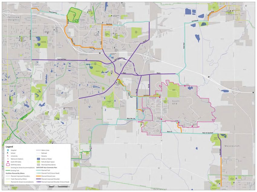
There are three categories of facility types recommended for the SAFB Shift Your Commute plan. They
are as follows (definitions and photos of the facility types are shown on the following pages):
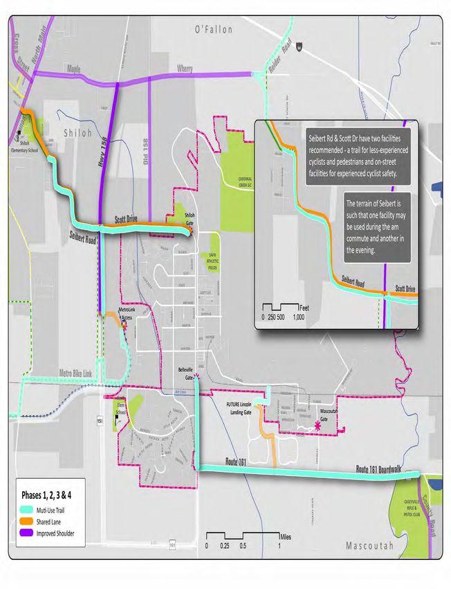
1. May-Use-Full-Lane Signs & Shared Lane Markings (Sharrows)
2. Improved Shoulders
3. Multi-Use Trails
19• Sharrows & Signs: On-street pavement markings that designate Bicycle Routes along with the
area of the traffic lane that is recommended for use by cyclists. “May Use Full Lane” Signs,
for awareness, safety and wayfinding, are also used in this facility. The combination of signs
and pavement markings (including through intersections) designates these roadways as the
“preferred” locations for on-street cycling.
Plan Principles
20• Improved Shoulders: While the width of the shoulders on the roadways recommended for this
facility are typically more than adequate, their surface materials are not. This recommendation
includes replacing the current oil and chip surface with a standard asphalt surface - an
extension of the surface used in the roadway. Further construction guidelines include painting
these shoulders a bright green color and stenciling sharrows on them. Roadside signs are also
recommended, such as “Bikes on Shoulder” for safety and wayfinding/route designation. The
use of this facility eliminates the need for road-widening and related expenses to accommodate
bicycle lanes.
Plan Principles
21• Multi-Purpose Trail: Multi-Use Trails are 10-12 feet wide (or greater) with a continuous smooth
paved surface such as asphalt or concrete, and accommodate bi-directional flow on their own
right-of-way. Recommended for only one side of a roadway, these facilities accommodate all
levels of users.
Trail crossing best practices: flashing signs and
painted crosswalks
Plan Principles
Automobile deterrent
devices: flex-post
bollard and signs
10-12 ft w
ide
Yellow-dashed
line indicates
bi-directional
traffic
22Estimated Preliminary Expenses
Street Name/Label Recommended Facility Length (ft) Length (mi) Estimated Cost
Cross Street Improved Shoulder 10,844 2.1 $1,496,464
Future Frank Scott Ext. Improved Shoulder 10,405 2.0 $1,435,881
Hwy 158 Improved Shoulder 9,922 1.9 $1,369,266
Hwy 50 Improved Shoulder 2,745 0.5 $378,806
Lebanon Improved Shoulder 12,767 2.4 $1,761,877
Maple Improved Shoulder 6,104 1.2 $842,358
North Main Improved Shoulder 10,837 2.1 $1,495,495
Old 158 Improved Shoulder 6,234 1.2 $860,358
Scott-Troy Road Improved Shoulder 5,141 1.0 $709,455
Wherry Improved Shoulder 9,816 1.9 $88,340
County Road Improved Shoulder & Sidewalks 7,101 1.3 $1,526,729
Frank Scott Pkwy Improved Shoulder & Sidewalks 23,367 4.4 $5,023,916
Plan Principles
Belleville Street Shared Lane 7,299 1.4 $10,657
Chesapeake Jct Ln Shared Lane 2,509 0.5 $3,663
Lincoln Shared Lane 6,834 1.3 $9,978
Lincoln Landing Connector Shared Lane 3,915 0.7 $5,716
MetroLink Shared Lane 2,075 0.4 $3,030
Pierce Blvd Shared Lane 7,114 1.3 $10,386
Regency Park Shared Lane 4,722 0.9 $6,894
Regency Park Shared Lane 3,933 0.7 $5,742
Scott Drive Shared Lane 6,437 1.2 $9,398
Seibert Road Shared Lane 9,063 1.7 $13,232
Seibert-158 Intersection Shared Lane 325 0.1 $474
State Street Shared Lane 3,087 0.6 $4,507
Venita Dr Shared Lane 3,695 0.7 $5,395
County Road Shared Lane & Sidewalks 8,214 1.6 $644,484
Future Roadway Trail 8,040 1.5 $546,694
Lincoln Landing Connector Trail 1,814 0.3 $123,328
Metro BikeLink Connector Trail 23,207 4.4 $1,578,065
Old Collinsville Road Trail 7,841 1.5 $533,218
Old Collinsville Road Trail 6,790 1.3 $461,706
Old Vincennes Trail Trail 10,683 2.0 $726,477
Reider Road Trail 20,569 3.9 $1,398,724
Route 161 Trail 5,622 1.1 $382,301
Route 161 Trail 4,604 0.9 $313,038
Route 161 Boardwalk Trail 5,851 1.1 $2,632,859
Scott Drive Trail 3,846 0.7 $261,539
Scott Drive Trail 6,462 1.2 $439,437
Scott Drive-Metro Connector Trail 3,716 0.7 $252,694
Seibert Road Trail 5,719 1.1 $388,863
US 50 Bypass Trail 7,640 1.4 $519,549
Grand Totals: 306,910 58 $28,280,992
23Facility Type Construction Estimates* (2012)
Page 23 shows the grand totals for estimated implementation of the SAFB Shift Your Commute Plan.
Below are general estimates for the construction of each type of facility. These categories were
incorporated into the Geographic Information Systems (GIS) map of the planned facilities. These
Preliminary Cost Estimate (All costs shown in per foot of roadway)
estimates confirm the long-range nature of the SYC Plan, providing SAFB and City officials and staff
with a 20-year implementation time frame.
Multi-Use Trail
*Preliminary construction
Separated estimates10'
from Roadway, provided courtesy
width, 3" of Horner
HMA Surface, & Shifrin, Base
6' Aggregate Inc. Engineers Cost/FT
Earth Excavation $4.50
May-Use-Full-LaneAggregate
Sign: Base $0.66 / lf
Course
Sharrow: $0.80 / lf $11.90
Hot-Mix Asphalt Surface $28.12
Improved Shoulder: $138 / lf Multi-Use Trail: $68
Misc. Items (Signs, Swales, Culverts, Seeding, Prime Coat, / lf
ETC) $15.00
Subtotal $59.52
+15% Contingency $8.93
Total - Per Roadway Centerline $68.45
Rounded Total $68
Plan Principles
Preliminary Cost Estimate (All costs shown in per foot of roadway)
Pedestrian Path
Multi-UseSeparated
Trail from Roadway, 6' width, 3" HMA Surface, 6' Aggregate Base Cost/FT
Separated Earth Excavation10' width, 3" HMA Surface, 6' Aggregate Base
from Roadway, $2.70
Cost/FT
Aggregate Base Course
Earth Excavation $7.14
$4.50
Hot-Mix Asphalt
Aggregate Base Surface
Course $16.87
$11.90
Misc. Items
Hot-Mix (Signs,
Asphalt Swales, Culverts, Seeding, Prime Coat, ETC)
Surface $15.00
$28.12
Subtotal Misc. Items (Signs, Swales, Culverts, Seeding, Prime Coat, ETC) $41.71
$15.00
Subtotal +15% Contingency $6.26
$59.52
Total - Per +15%
Roadway Side
Contingency $47.97
$8.93
Total
Total - Per Roadway Centerline
- Per Roadway Centerline x2 $95.93
$68.45
Rounded
Rounded Total
Total $96
$68
Sidewalk
Pedestrian Path
Separated
Separated from
from Roadway,
Roadway, 6'5
5' width,
width, 4
4"
3" Concrete
HMA Surface, 6' Aggregate Base Cost/FT
Cost/FT
Earth Excavation
Earth Excavation $2.00
$2.70
Concrete
AggregateSidewalk
Base Course $27.50
$7.14
Misc. Items
Hot-Mix (Swales,
Asphalt Seeding, ETC)
Surface $5.00
$16.87
Subtotal Misc. Items (Signs, Swales, Culverts, Seeding, Prime Coat, ETC) $34.50
$15.00
Subtotal +15% Contingency $5.18
$41.71
Total - Per +15%
Roadway Side
Contingency $39.68
$6.26
Total
Total -- Per
Per Roadway
Roadway Centerline
Side x2 $79.35
$47.97
Total - Per Roadway Centerline Rounded Total
x2 $77
$95.93
Rounded Total $96
Improved
Improved Shoulder
Shoulder
SidewalkReplace
Replace Existing
Existing Shoulders,
Shoulders, 10'
10' width,
width, 8"
8" HMA
HMA full
full depth
depth Shoulders
Shoulders Cost/FT
Cost/FT
Earth Excavation
EarthRoadway,
Excavation5 $3.17
$3.17
Separated from 5' width, 4
4" Concrete Cost/FT
Hot-Mix
Hot-Mix Asphalt
Asphalt Shoulders
Shoulders $48.69
$48.69
Earth Excavation $2.00
Rumble
Rumble Strip
Strip 16"
16" $1.00
$1.00
Concrete Sidewalk $27.50
Painting
Painting (Sharrows,
(Sharrows, Buffer Hatching, Bike Symbols) $2.26
Misc. Items (Swales, Buffer
Seeding,Hatching,
ETC) Bike Symbols) $2.26
$5.00
Misc. Items (Signs, Swales, Seeding, ETC) $5.00
Subtotal Misc. Items (Signs, Swales, Seeding, ETC) $5.00
$34.50
Subtotal
Subtotal +15% Contingency $60.12
$60.12
$5.18
+15% Contingency
+15%
Total - Per Roadway Contingency
Side $9.02
$9.02
$39.68
Total
Total -
- Per
Per Roadway
Roadway Side
Side
Total - Per Roadway Centerline x2 $69.14
$69.14
$79.35
Total -- Per
Total Per Roadway
Roadway Centerline
Centerline x2
x 2 $138.28
$138.28
Rounded Total $77
Rounded
Rounded Total
Total $138
$138
Notes:
Notes: Estimates
Estimates assume
assume embankment
embankment inin place
place to
to construct
construct accommodations.
accommodations.
Estimates do not include any ROW or easements costs.
Estimates do not include any ROW or easements costs.
Estimates are
Estimates are in
in 2012
2012 dollars
dollars
24Potential Funding Sources
Below is a listing of funding sources recommended to aid the Base and Cities in the implementation of
this plan.
Grant Program Type Match $ Amount Website:
Illinois Transportation Constr. 20% $15-25M Avg www.dot.state.il.us/
Enhancements Program (ITEP)
Congestion Mitigation & Air Constr. 20% $5-7M Avg www.dot.state.il.us/
Quality (CMAQ)
Illinois State Bike Paths Grant Constr. 50% $200K-$1M www.dot.state.il.us/
Highway Safety Improvement Constr. www.dot.state.il.us/
Program (HSIP)
Safe Routes to School Constr./Ed None $5-7M Avg www.dot.state.il.us/
Pedestrian & Bicycle Safety Ed & Enfor. www.dot.state.il.us/
Plan Principles
Program (PBS)
Injury Prevention Program Ed Only www.dot.state.il.us/
Surface Transportation Constr. 20% www.dot.state.il.us/
Program (STP)
Open Space Lands Acquisition Constr. min. 51% up to $400K dnr.state.il.us/
& Development (OSLAD)
Recreational Trails Program Constr. 20% $1 M Avg dnr.state.il.us/
Tourism Attraction Constr. min. 51% up to $1M www.commerce.state.il.us/
Development Grant (TAP)
Community Development Constr. www.commerce.state.il.us/
Assistance Program
National Scenic Byways Grant-- Constr. 20% bywaysonline.org/grants
must be along byway
Land & Water Conservation Constr. min. 51% www.nps.gov/
Fund (LWCF)
Preserve America Grant Constr. www.nps.gov/
Transportation, Community, & Plan/Imp http://www.fhwa.dot.gov/dis-
System Preservation Program cretionary/tcsp2012info.htm
Kodak American Greenways Constr. http://www.conservationfund.
org/kodak_awards
Bikes Belong Coalition Grant Constr./Ed min. 51% up to $10K http://www.bikesbelong.org/
Please Note: The sources in green are now part of a single supply of funding that IDOT can participate/
allocate on an optional basis due to the federal transportation bill MAP-21. Availability will be determined
annually by the state.
25Pedal Past the Pumps
and TravelGreen!
The TravelGreen program
promotes commuter cycling
and increases awareness of
cycling safety in the St. Louis
region. Trailnet works with local
businesses, communities, and
universities to address the built
environment, policies, and social
networks in order to promote
bicycle commuting among
individuals. The TravelGreen
program identifies and engages
Plan Principles
a strong cycling contingent—
those who are ready to change WE KNOW A
old behaviors and shift gears
toward a healthier commute.
BETTER WAY
We’ve found a way to get to work that helps
us save money, get some exercise and have
more fun. Now’s the perfect time to join us!
Why Shift Your Commute?
Join Trailnet’s ongoing effort
Meet other St. Louis bike commuters and sign-up to win prizes at
to encourage individuals to SHIFTYOURCOMMUTE.COM
bicycle commute. Sign up as
an individual to log the car-
free miles you commute and
in turn, learn how many carbon emissions you saved and calories you burned. Can’t do your whole
commute by bike or walk? Combine the MetroBus or MetroLink with your commute (both equipped
with bike racks) and expand the distance you can go car-free. There are so many reasons to shift your
commute...What’s your reason?
• The average person loses 13 lbs their first year of commuting by bike.
• Just three hours of bicycling per week can reduce your risk of heart disease and stroke by 50%.
• The U.S. could save 462 million gallons of gasoline a year by increasing cycling from 1% to 1.5%
of all trips.
• Each U.S. rush-hour auto commuter spends an average of 50 hours a year stuck in traffic.
• In 2003, cars stalled in traffic wasted 5 billion gallons of fuel.
• In 1964, 50% of kids rode to school and the obesity rate was 12%... In 2004, 3% rode to school
and the obesity rate was 45%.
• 50% of the working population commutes five miles or less to work.
(Statistics retrieved from Trek Bicycle Corporation located at 1world2wheels.org)
2010 Results:
Riders: 10,372 Workplaces: 723
Teams: 1,677 Miles biked: 1,082,886
26Implementation
Prioritization
                          There are 40 recommended facilities in the Scott AFB Shift Your Commute Plan. A combination of
                          sources was utilized to create a “prioritization matrix” including on-line and paper survey responses,
                          comments provided at the second open house, and estimated cost. The completed matrix was
                          then analyzed for construction efficiency, and below is a summary of the results. This is the “order”
                          recommended for implementation at the project area scale. Each jurisdiction and/or municipality
                          should prioritize their facilities in whichever order makes the most sense for their own needs.

                          The table is also further categorized into “phases”. There are 16 phases based on project expense
                          and geographic efficiency for construction (again, project area scale). Through inter-jurisdiction
                          cooperation, the region can achieve the 20-year implementation time line. The phases are shown on
                          four maps on the following pages.

                  Phase            Street Name/Label              Recommended Facility       Feet    Miles    Est. Cost       Juris.
                             Route 161                         Trail                        10,226     2       $695,339    State
                      1
                             Scott Drive (Belleville Gate)     Trail                         3,846    0.7      $261,539    County
                             Seibert Road                      Trail                         5,719    1.1      $388,863    Shiloh
                             Seibert Road                      Shared Lane                   9,063    1.7       $13,232    Shiloh
                      2      Seibert-158 Intersection          Shared Lane                    325     0.1            TBD   State
                             Scott Drive (Shiloh-Scott Gate)   Shared Lane                   6,437    1.2         $9,398   Shiloh
                             Scott Drive (Shiloh-Scott Gate)   Trail                         6,462    1.2      $439,437    Shiloh
                      3      Route 161 Boardwalk               Trail                         5,851    1.1    $2,632,859    State
                      4      Hwy 158/Air Mobility              Improved Shoulder             9,922    1.9    $1,369,266    State
                             Cross Street                      Improved Shoulder            10,844    2.1    $1,496,464    County
                      5
                             Lincoln                           Shared Lane                   6,834    1.3         $9,978   O’Fallon
                      6      Frank Scott Pkwy                  Impr. Shoulder & Sidewalks   23,367    4.4    $5,023,916    County
Implementation

                             Lincoln Landing Connector         Shared Lane                   3,915    0.7        $5,716    SAFB
                             Lincoln Landing Connector         Trail                         1,814    0.3      $123,328    SAFB
                      7
                             Scott-Troy Road                   Improved Shoulder             5,141    1.0      $709,455    County
                             Hwy 50                            Improved Shoulder             2,745    0.5      $378,806    State
                             Reider Road                       Trail                        20,569    3.9    $1,398,724    County
                      8      US 50 Bypass                      Trail                         7,640    1.4      $519,549    Private
                             Belleville Street                 Shared Lane                   7,299    1.4       $10,657    Lebanon
                             Lebanon                           Improved Shoulder            12,767    2.4    $1,761,877    County
                      9
                             North Main                        Improved Shoulder            10,837    2.1    $1,495,495    Shiloh
                             Wherry                            Improved Shoulder             9,816    1.9       $88,340    Multiple
                      10     Maple                             Improved Shoulder             6,104    1.2      $842,358    Shiloh
                             Old 158                           Improved Shoulder             6,234    1.2      $860,358    Shiloh
                      11     Old Collinsville Road             Trail                        14,631    2.8      $994,924    Multiple
                             County Road (177 to Fuesser)      Shared Lane & Sidewalks       8,214    1.6      $644,484    Mascoutah
                      12
                             County Road (Fuesser to 161)      Impr. Shoulder & Sidewalks    7,101    1.3    $1,526,729    Mascoutah
                             Old Vincennes Trail               Trail                        10,683    2.0      $726,477    O’Fallon
                      13
                             State Street                      Shared Lane                   3,087    0.6         $4,507   O’Fallon
                      14     Future Frank Scott Ext.           Improved Shoulder            10,405    2.0    $1,435,881    County

                 30
You can also read


