Screening for Appropriate Assessment - Proposed housing development at Lindisfarne, Dublin 22 12 August 2020 - South Dublin County ...
←
→
Page content transcription
If your browser does not render page correctly, please read the page content below
Screening for Appropriate Assessment
   Proposed housing development at
        Lindisfarne, Dublin 22
            12 August 2020

          NM Ecology Ltd - Consultant Ecologists
           276 Harold’s Grange Road, Dublin 16
             Website: www.nmecology.com
               Email: info@nmecology.com
                    Tel: 087-6839771
Screening for Appropriate Assessment Lindisfarne, Dublin 22
Executive Summary
This Screening for Appropriate Assessment report has been prepared by NM Ecology Ltd
on behalf of South Dublin County Council (the applicant), as part of a planning application
for a site at Lindisfarne, Clonburris, Dublin 22. The proposed development will consist of
28 new residences and ancillary works.
In accordance with their obligations under the European Communities (Birds and Natural
Habitats) Regulations 2011 (SI 477/2011), the planning authority must assess whether the
proposed development could have ‘likely significant effects’ on any Natura 2000 sites.
This document provides supporting information to assist the authority with an
Appropriate Assessment screening exercise, including: a description of the proposed
development, a review of the site’s environmental setting, details of Natura 2000 sites
within the potential zone of impact, an appraisal of source-pathway-receptor
relationships, and an assessment of potential impacts.
It is concluded that the proposed development will not cause direct or indirect impacts
on any Natura 2000 sites, either alone or in combination with other plans or projects, and
thus that Appropriate Assessment is not required.
1Screening for Appropriate Assessment Lindisfarne, Dublin 22
1 Introduction
1.1 Background to Appropriate Assessment
Approximately 10% of the land area of Ireland is included in the European Network of Natura
2000 sites, which includes Special Protection Areas (SPAs) to protect important areas for birds,
and Special Areas of Conservation (SACs) to protect a range of habitats and species. Legislative
protection for these sites is provided by the European Council Birds Directive (79/409/EEC) and
E.C. Habitats Directive (92/43/EEC, as amended), which are jointly transposed into Irish law by
the European Communities (Birds and Natural Habitats) Regulations 2011 (SI 477/2011, as
amended).
Regulation 42 (1) states that: “Screening for Appropriate Assessment of a plan or project for
which an application for consent is received […] shall be carried out by the public authority to
assess, in view of best scientific knowledge and in view of the conservation objectives of the site,
if that plan or project, individually or in combination with other plans or projects is likely to have
a significant effect on [any Natura 2000 sites].” To ensure compliance with this regulation,
public authorities must screen all planning applications for potential impacts on Natura 2000
sites. Supporting information may be requested from the applicant to assist with this process.
This document provides background information to assist South Dublin County Council with a
Screening for Appropriate Assessment exercise for the proposed development. It includes a
description of the proposed development, a review of the site’s environmental setting, details
of Natura 2000 sites within the potential zone of impact, an appraisal of source-pathway-
receptor relationships, and an assessment of potential impacts.
1.2 Statement of authority
This report was written by Nick Marchant, the principal ecologist of NM Ecology Ltd. He has an
MSc in Ecosystem Conservation and Landscape Management from NUI Galway and a BSc in
Environmental Science from Queens University Belfast. He is a member of the Chartered
Institute of Ecology and Environmental Management, and operates in accordance with their
code of professional conduct.
He has thirteen years of professional experience, including ten years as an ecological consultant,
one year as a local authority biodiversity officer, and two years managing an NGO in Indonesia.
He provides ecological assessments for developments throughout Ireland and Northern Ireland,
including wind farms, infrastructural projects (roads, water pipelines, greenways, etc.), and a
range of residential and commercial developments.
2Screening for Appropriate Assessment Lindisfarne, Dublin 22
1.3 Methods
This report has been prepared with reference to the following guidelines:
• Appropriate Assessment of Plans and Projects in Ireland (Department of the
Environment, Heritage and Local Government, 2009)
• Assessment of plans and projects significantly affecting Natura 2000 sites:
Methodological guidance on the provisions of Article 6(3) and (4), E.C., 2002.
• Guidelines for Ecological Impact Assessment in the UK and Ireland: Terrestrial,
Freshwater and Coastal (Chartered Institute of Ecology and Environmental
Management, 2019)
In accordance with Section 3.2 of Appropriate Assessment of Plans and Projects in Ireland, the
screening exercise was conducted using the following steps:
1. Description of the project and local site characteristics
2. Identification of relevant Natura 2000 sites, and compilation of information on their
qualifying interests and conservation objectives
3. Assessment of potential impacts upon Natura 2000 sites, including:
• Direct impacts (e.g. loss of habitat area, fragmentation)
• Indirect impacts (e.g. disturbance of fauna, pollution of surface water)
• Cumulative / ‘in-combination’ effects associated with other concurrent projects
4. Screening Statement with conclusions
A desk-based study was carried out using data from the following sources:
• Plans and specifications for the proposed development
• Qualifying interests / conservation objectives of Natura 2000 sites from www.npws.ie
• Bedrock, soil, subsoil, surface water and ground water maps from the Geological
Survey of Ireland webmapping service (www.gsi.ie/mapping.htm), the National
Biodiversity Data Centre (http://maps.biodiversityireland.ie/), and the Environmental
Protection Agency web viewer (http://gis.epa.ie/Envision/)
• The South Dublin County Development Plan 2016 – 2022, and details of permitted or
proposed developments from the local authority’s online planning records
All web-based resources were accessed in August 2020.
3Screening for Appropriate Assessment Lindisfarne, Dublin 22
2 Description of the Project
2.1 Environmental setting
Site location and surroundings
The site currently consists of amenity grassland, with some footpaths and a small number of
trees. It is bordered to the south, east and west by existing residences, and by internal roads
within the Lindisfarne and Melrose housing estates. The northern boundary is formed by Lock
View Road.
The surrounding area is predominantly in residential use, with some schools / colleges and small
commercial facilities. To the north of Lock View road there is an expanse of amenity grassland,
and the Grand Canal. There are some abandoned agricultural pastures to the north of the canal;
this area will form part of the Clonburris Strategic Development Zone (refer to Section 2.3).
Geology and soils
The underlying bedrock is limestone and shale, which is a locally-important aquifer (Geological
Survey of Ireland). Sub-soils are limestone till, and soils are grey-brown podzolics / brown
earths, which are deep, neutral/alkaline and well drained. As the soil and bedrock is well
drained, it is expected that most rainwater falling on the site would percolate to ground rather
than flowing over land.
Hydrology
The closest waterbody is the Grand Canal, which is located approximately 100 - 150m north of
the proposed development site. The canal is a proposed Natural Heritage Area (protected under
the Wildlife (Amendment) Act 2000) in recognition of its diversity of habitats and value as an
ecological dispersal route. Although water quality in the canal is not monitored, it is considered
to be unpolluted, as it is a self-contained hydrological unit that is isolated from surrounding
lands and does not receive surface water / waste water discharges. The canal has a series of
locks that reduce its flow rate to very low levels. It discharges to the River Liffey estuary at Grand
Canal Dock approx. 13.5 km to the east of the site.
The closest major river is the Camac River, which passes approximately 1.2 km to the south-east
of the proposed development site. The river runs in a north-easterly direction and joins the
River Liffey at Heuston Station approximately 10 km downstream. The Griffeen River is located
approx. 2.2 km to the west of the proposed development site. It flows north and joins the River
Liffey approx. 3.5 km downstream.
Under the Water Framework Directive Status assessments 2013 – 2018, the Camac River is
currently of Poor status within Dublin City, and the Griffeen River is of Good Status. The River
Liffey estuary is of Good status, as are the coastal waters of Dublin Bay.
4Screening for Appropriate Assessment Lindisfarne, Dublin 22
2.2 Description of the proposed development
The development will comprise 28 residences in a range of designs. Road access will be from
the Lindisfarne and Melrose housing estates, and on-street parking will be provided in these
areas and along Lock View Road. Some houses will have private gardens, and public green space
will be provided in the north of the site.
Detailed drainage proposals have not yet been developed; they have been deferred to the
detailed design phase. It is expected that foul water will be discharged to local authority foul
water sewers on adjoining roads, and will be treated in the Ringsend Waste Water Treatment
Plant. Most rainwater falling on external areas and permeable paving will percolate to ground.
It is expected that runoff from roofs and external hard surfaces will be discharged to local
authority surface water sewers, and will be ultimately be discharged to a local watercourse.
2.3 Other nearby developments (potential in-combination effects)
The proposed development site is located in a suburban setting in the west of Dublin city. The
site and adjoining housing estates are included in zone R2 ‘Existing residential’ of the South
Dublin County Council Development Plan 2016 -2022, for which the planning objective is “To
protect and/or improve residential amenity”. As most of this area is already in residential use, it
is not expected that there will be significant development pressure in this zone in the future.
Land to the north of the site is included in zone R3 ‘Residential, mixed residential and other
uses’, and specifically in zone SDZ, for which the planning objective is “To provide for strategic
development in accordance with approved planning schemes”. This area is included in the
Clonburris Strategic Development Zone, which was approved by An Bórd Pleanála in 2019. The
plan provides a framework for future residential, commercial and educational uses in the future.
However, the land between the proposed development site and the Grand Canal is designated
as a public park, matching the current land use. Therefore, there will be no significant
development in the immediate vicinity of the proposed development site.
Live and recently-approved planning applications in the vicinity of the site were reviewed on
the online planning records of South Dublin County Council. A rapid-build housing development
was approved at St Cuthbert’s Park in 2016 (planning reference SD168/0007), approx. 350 m
south of the proposed development site. It is understood that this development is currently
nearing completion, and it will be complete before the construction of the proposed
development, so there is no risk of in-combination effects.
All other recent applications in the surrounding area were for small-scale developments such as
residential extensions or alterations. None were considered to pose a risk of in-combination
effects.
5Screening for Appropriate Assessment Lindisfarne, Dublin 22
3 Description of Natura 2000 sites
3.1 Identification of Natura 2000 sites within the zone of influence
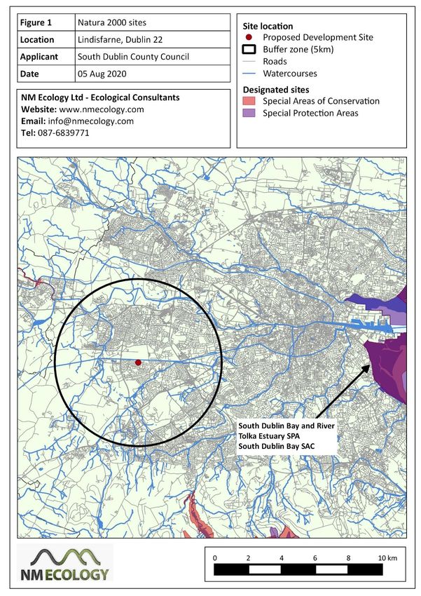
There are no Natura 2000 sites within 5 km of the proposed development site (Figure 1).
However, considering its proximity to the Grand Canal and other watercourses, which are
connected to the River Liffey, the potential zone of impact1 was extended eastwards to include
the Natura 2000 sites in Dublin Bay. A map of relevant sites is shown in Figure 1, and a
description of each site is presented in Table 1. Distances are measured along connecting
watercourses.
Table 1: Natura 2000 sites of relevance to the proposed development site
Site Name Distance Qualifying Interests
South Dublin 17 km Habitats: coastal wetlands
Bay and River downstream Special conservation interests: light-bellied brent goose,
Tolka Estuary oystercatcher, ringed plover, grey plover, knot,
SPA (site code sanderling, dunlin, bar-tailed godwit, redshank, black-
4024) headed gull (wintering populations), arctic tern, roseate
tern (passage), and common tern (breeding and passage)
South Dublin 17.5 km Annex I habitats: inter-tidal mudflats / sandflats
Bay SAC (210) downstream Annex II species: none
North Dublin 20 km Annex I habitats: inter-tidal mudflats / sandflats
Bay SAC (206) downstream (including patches of Salicornia and other annuals),
Spartina swards, salt marshes, annual vegetation of drift
lines, embryonic shifting dunes, white dunes, grey
dunes, dune slacks
Annex II species: petalwort Petalophyllum ralfsii
North Bull 20 km Habitats: coastal wetlands
Island SPA downstream Special conservation interests: wintering populations of
(4006) light-bellied brent goose, Shelduck, teal, pintail,
shoveler, oystercatcher, golden plover, knot, sanderling,
dunlin, black-tailed godwit, bar-tailed godwit, curlew,
redshank, turnstone, black-headed gull
1
In Appropriate Assessment of Plans and Projects in Ireland, it is noted that the potential ‘zone of impact’ of a
development “must be evaluated on a case-by-case basis with reference to the nature, size and location of the
project, the sensitivities of the ecological receptors, and the potential for in-combination effects.”
6Screening for Appropriate Assessment Lindisfarne, Dublin 22
7Screening for Appropriate Assessment Lindisfarne, Dublin 22
3.2 Conservation objectives
The standard conservation objective for all SACs and SPAs in Ireland is “to maintain or restore
the favourable conservation condition of the qualifying interests for which the SAC / SPA has
been selected”. In addition, the Department of Culture, Heritage and the Gaeltacht has
produced detailed conservation objectives for the sites listed in Table 1. They can be viewed on
the website of the National Parks and Wildlife Service (http://www.npws.ie/protected-sites),
but are not reproduced here in the interests of brevity.
3.3 Identification of potential pathways for indirect impacts
Indirect impacts can occur if there is a viable pathway between the source (the proposed
development site) and the receptor (the habitats and species for which a Natura 2000 site has
been designated). The most common pathway for impacts is surface water, e.g. if a pollutant
reaches a river and is carried downstream into a Natura 2000 site. Other potential pathways are
groundwater, air (e.g. airborne dust or sound waves), or land (e.g. flow of liquids, vibration).
The zone of effect for hydrological impacts can be several kilometres, but for air and land it is
rarely more than one hundred metres. An appraisal of potential pathways for impacts on Natura
2000 sites is provided below.
In theory, the Grand Canal, Camac River and / or Griffeen River could provide a hydrological
pathway to the River Liffey, and subsequently to the Natura 2000 sites in Dublin Bay. However,
the Grand Canal is located more than 100 m from the proposed development site, and any
overland runoff would be intercepted by the drainage system along the Lock View Road. The
canal is a self-contained hydrological unit that does not receive discharges from surrounding
sewers or road drains. The River Camac and Griffeen Rivers are located more than 1 km away.
Therefore, none of these waterbodies could provide a potential hydrological pathway to the
Natura 2000 sites in Dublin Bay.
All other pathways (groundwater, air, land) can be ruled out due to the distance involved. On
this basis, there are no potential pathways for indirect impacts on any of the Natura 2000 sites
in Dublin Bay.
4 Assessment of potential impacts
4.1 Direct impacts
The proposed development site is not located within or adjacent to any Natura 2000 sites, so
there is no risk of habitat loss, fragmentation or any other direct impacts.
8Screening for Appropriate Assessment Lindisfarne, Dublin 22
4.2 Indirect impacts
Potential changes in water quality (construction phase)
Construction works typically generate fine sediments, and may occasionally cause accidental
spills of oil or other toxic chemicals, which can be harmful to aquatic / marine habitats and
species. However, as outlined in Section 3.3, there are no viable surface-water (or other)
pathways between the proposed development site and any Natura 2000 sites. Consequently,
the risk that pollutants from the construction site could cause significant negative impacts on
any Natura 2000 sites is negligible, even in a worst-case scenario and in the absence of standard
site-management measures.
Potential changes in water quality (operational phase)
Although detailed drainage proposals have not yet been developed, it is expected that foul
water from the proposed development will be discharged to local authority sewers and treated
in the Ringsend waste water treatment plant. The plant is currently within capacity and
providing a high level of treatment before discharge to Dublin Bay. The receiving waters in
Dublin Bay are currently of Good Status.
It is expected that surface-water runoff from hard surfaces will be discharged to local authority
surface water sewers along Lock View Road. The discharge points for the surface water sewers
is not known, but it is expected to be the Camac River or Griffeen River. Public surface water
sewers typically incorporate oil and/or silt interceptors to remove trace quantities of pollutants.
On this basis, surface water runoff is considered to be unpolluted, and would not pose a risk to
receiving waters.
Consequently, it is concluded that foul water and surface water discharges during the operation
of the development would not cause significant impacts on water quality in any Natura 2000
sites.
4.3 Potential in-combination effects
As the proposed development will not have any impacts on nearby waterbodies or Natura 2000
sites, there is no risk of in-combination effects with other concurrent developments.
9Screening for Appropriate Assessment Lindisfarne, Dublin 22
5 Conclusion of Stage 1: Screening Statement
In Section 3.2.5 of Appropriate Assessment of Plans and Projects in Ireland (NPWS 2010), it is
stated that the first stage of the AA process can have three possible conclusions:
1. AA is not required
Screening, followed by consultation and agreement with the NPWS, establishes that the
plan or project is directly connected with or necessary to the nature conservation
management of the site
2. No potential for significant effects / AA is not required
Screening establishes that there is no potential for significant effects and the project or
plan can proceed as proposed.
3. Significant effects are certain, likely or uncertain
The plan or project must either proceed to Stage 2 (AA), or be rejected.
Having considered the particulars of the proposed development, we conclude that this
application meets the second conclusion, because there is no risk of direct or indirect impacts
on any Natura 2000 sites. Therefore, with regard to Article 42 (7) of the European Communities
(Birds and Natural Habitats) Regulations 2011, it can be excluded on the basis of objective
scientific information following screening, that the plan or project, individually or in
combination with other plans or projects, will have a significant effect on a European site.
Therefore, we conclude that Appropriate Assessment is not required.
References
Chartered Institute of Ecology and Environmental Management, 2019. Guidelines for Ecological
Impact Assessment in the U.K and Ireland: Terrestrial, Freshwater and Coastal (2nd Edition).
C.I.E.E.M., Hampshire, England.
Department of the Environment, Heritage and Local Government, 2009. Appropriate
Assessment of Plans and Projects in Ireland. National Parks and Wildlife Service, DAHG, Dublin,
Ireland.
European Commission. 2002. Assessment of plans and projects significantly affecting Natura
2000 sites: Methodological guidance on the provisions of Article 6(3) and (4) of the Habitats
Directive 92/43/EEC. Office for Official Publications of the European Communities, Luxembourg.
10You can also read