HELCOM Baltic Sea Impact Index and its use in Maritime Spatial Planning
←
→
Page content transcription
If your browser does not render page correctly, please read the page content below
Baltic Marine Environment Protection Commission
                   Report by HELCOM Secretariat, HASPS 2 project
                   July 2018

HELCOM Baltic Sea Impact Index and its use in Maritime Spatial Planning
Introduction
HELCOM (Baltic Marine Environment Protection Commission - Helsinki Commission) is the governing body
of the Convention on the Protection of the Marine Environment of the Baltic Sea Area, known as the
Helsinki Convention. The Contracting Parties are Denmark, Estonia, the European Union, Finland,
Germany, Latvia, Lithuania, Poland, Russia and Sweden. HELCOM's vision for the future is a healthy Baltic
Sea environment with diverse biological components functioning in balance, resulting in a good ecological
status and supporting a wide range of sustainable economic and social activities.

The growing competition for limited marine space is increasing the need to plan the sustainable use of our
marine areas. Maritime spatial planning is answering to this challenge by introducing a public process to
plan our activities at seas to achieve ecological, economic and social objectives. HELCOM, together with
VASAB, is playing an important role by facilitating a sea-basin level cooperation for MSP in Baltic Sea
Region (BSR). The common objective of the Baltic Sea countries cooperating within the HELCOM-VASAB
Maritime Spatial Planning Working Group is to establish maritime spatial plans that are coherent across
the borders and apply the ecosystem-approach.

Cumulative effect assessments (CEA), like the HELCOM Baltic Sea Impact Index (BSII), offer valuable
information for the MSP process by assessing the cumulative burden of human activities to the
environment.

Cumulative effect assessments evaluate the aggregated, collective, accruing and combined changes to the
environment that are a result of past, present and future human activities and natural processes. Judd et
al. (2015) described the CEA process as “systematic procedure for identifying and evaluating the significance
of effects from multiple pressures and/or activities on single or multiple receptors. CEA provides management
options, by quantifying the overall expected effect caused by multiple pressures and by identifying critical
pressures or pressure combinations and vulnerable receptors”.

The Baltic Sea is influenced by a range of different pressures, as a result of human activities at sea and in
its catchment area. If each activity and pressure is considered individually, it may appear to have little
importance. However, the summed impact may be considerable when the pressures take place in the
same area, in particular when acting on sensitive species or habitats. Cumulative effect assessment is a
tool to identify the extent and intensity of these impacts and to present them to the public and planners
(HELCOM 2018b).

                                                     1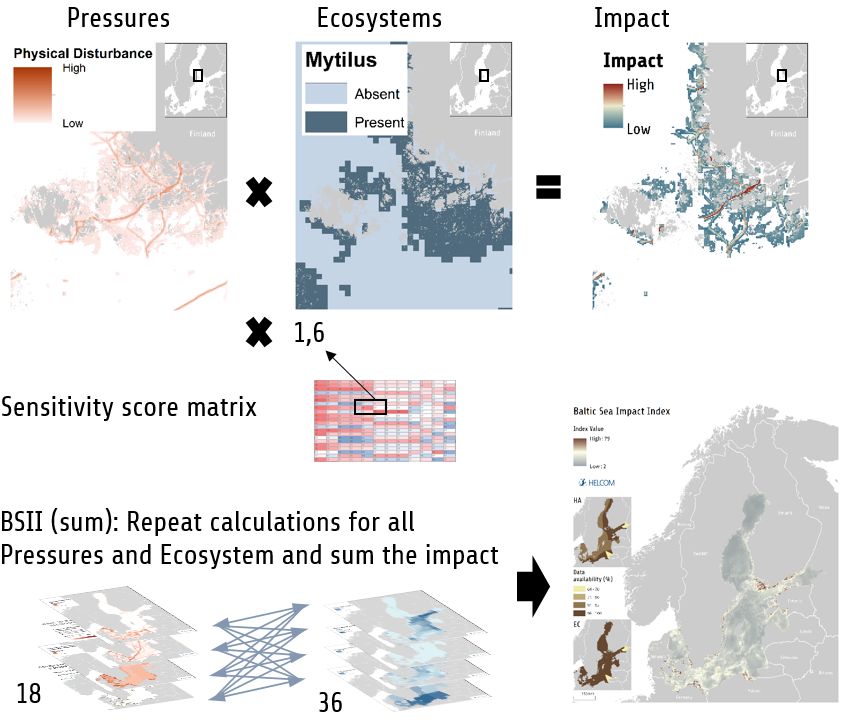
HELCOM Baltic Sea Impact Index
The HELCOM second holistic assessment of the ecosystem health of the Baltic Sea was published in July
2018. The main outcome, the “State of the Baltic Sea” report, provides an update on the environmental
situation in the Baltic Sea for the period 2011–2016 (HELCOM 2018a). The report captures a ‘moment’ in
the dynamic life history of the Baltic Sea, aiming to support an adaptive and regionally coordinated
management to improve the environmental status of the Baltic Sea. The main building blocks for the
assessment are HELCOM core indicators, thematic assessments, social and economic analyses and
cumulative impact assessment.
The assessment of cumulative impacts is carried out using the Baltic Sea Impact Index (BSII). The indicator-
based assessments show the status of pressures when assessed individually, without comparing their total
impact or how much they overlap with sensitive habitats. The Baltic Sea Impact Index is an assessment
component that additionally describes the potential cumulative burden on the environment for the whole
Baltic region and in different parts of the Baltic Sea.
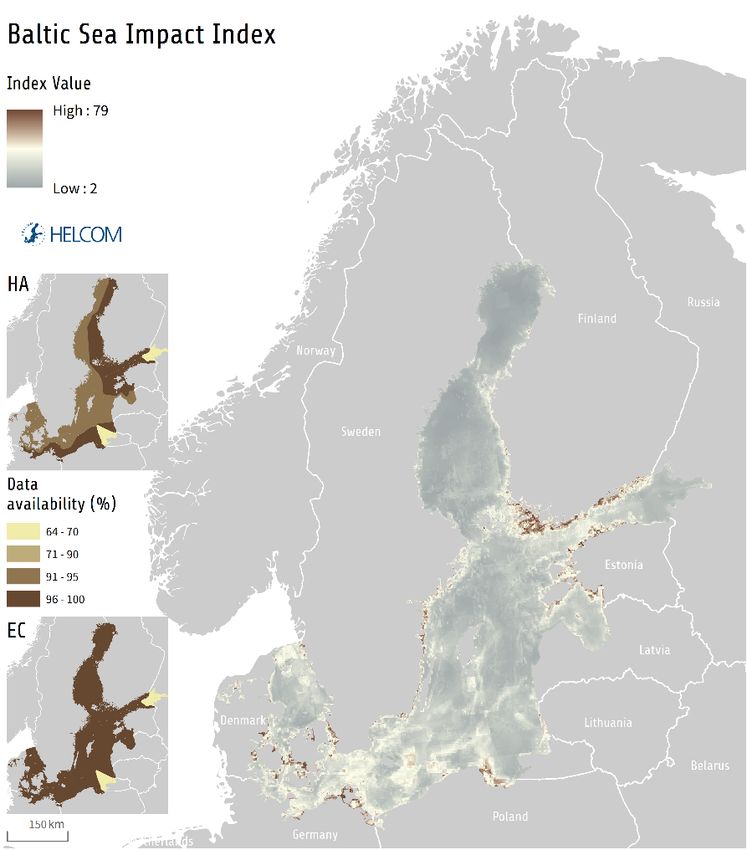
Results show that pressures from human activities occur everywhere in the Baltic Sea. The southwest
Baltic Sea and many coastal areas experience higher potential cumulative impacts than the northern areas
and many open sea areas (Figure 1). Most of the identified impacts were attributed to nutrient
concentrations and hazardous substances, followed by non-indigenous species, and the extraction of fish.
The most widely impacted ecosystem components in the Baltic Sea were the deep water habitats and
productive surface waters, the marine mammals (grey seal, harbour porpoise, ringed seal, and harbour
seal), as well as cod. A more detailed report on this assessment within HOLAS II is provided by HELCOM
(2018b).
Figure 1: Baltic Sea Impact Index
2
Methodology and data
The BSII methodology follows the concept originally created by Halpern et al. (2008), which has been
subsequently developed in the HARMONY project (Andersen et al. 2013), and customized further for the
Baltic Sea applicability in HOLAS II (HELCOM 2018). The basic principle of the method is to use an additive
model to detect the spatial pattern and the intensity of the cumulative burden to the environment. This is
carried out by synthesizing pressures, ecosystems and sensitivity scores to produce a map on the
distribution of cumulative impacts. The methodology used in HELCOM (2018a, b) is similar to the BSII used
in HELCOM initial holistic assessment (HELCOM 2010a, b), but the quality and coverage of the underlying
data sets has improved considerably.

The current BSII uses 18 aggregated pressure layers, 36 ecosystem components and a sensitivity matrix
linking these data sets (Figure 1). A huge data collation effort was undertaken to gather and harmonize the
data, utilizing the already existing data collection within HELCOM and additional data calls to the
countries, contributions from research projects and management authorities and the dedicated work of
HELCOM experts. Harmonized cross-border data sets of human activities and ecosystems for the whole
Baltic Sea give a unique opportunity to assess the cumulative impacts of human activities, on a Baltic-wide
scale.

Figure 2: Cumulative effect assessment using the BSII. Values of pressure layer (0-1), ecosystem component layer (0-1)
and corresponding sensitivity matrix value (0-2) are multiplied. Uppermost picture series shows an example for one
combination of a pressure layer (“physical disturbance”) and Ecosystem component layer (“Mytilus distribution”). This
is repeated for all the layer combinations and the results are summed to calculate the BSII.

                                                          3
Pressure layers describe different pressures the Baltic Sea environment is facing, covering activities at sea
and also pressures originating from human activities at land. The layers cover four pressure themes: Input
of substances (e.g. “Relative distribution of nitrogen concentration”), Input of energy (e.g. “Input of
continuous anthropogenic sound”), Biological pressures (e.g. “Introduction of non-indigenous species”)
and Physical pressures (e.g. “Physical disturbance”). The pressure layers were aggregated to have a
balanced number of data layers representing different types of pressures, all layers are normalized to have
values between 0 and 1. Altogether 39 human activities data sets and a large amount of monitoring data
have been used to produce the aggregated pressure layers.
Ecosystem components depict the distribution of selected habitats and species that are most important
in the Baltic Sea context. All layers are normalized to have values between 0 and 1. Data types for
ecosystem components include binary (e.g. benthic habitats), classified (e.g. mammals) and continuous
data (e.g. fish abundance).
The sensitivity scores used in this assessment were obtained from a survey answered by over eighty
experts in the Baltic Sea region. The sensitivity of each pressure to each ecosystem component was
analyzed, resulting in more than 600 unique sensitivity estimates.
Future development needs and lessons learned
The data sets and methodologies used in BSII for HOLAS II are based on the best available knowledge and
the accuracy and quality of the assessment has improved notably from the first BSII used in the initial
holistic assessment in 2010. Despite the work done to develop the index and underlying data, there are
still spatial and temporal gaps in some data sets that need to be resolved in the future. In addition, better
scientific knowledge is needed to assess the spatial extent and intensity of certain pressures and how they
should be considered as a pressure to begin with. Below are listed some future development needs:
- More attention should be given how the time period of the assessment is taken into account in
creating the data sets;
- Different options for the layers representing input of substances should be considered. Currently,
as decided by the Contracting Parties, e.g. input of nutrient pressure layers are created from
measurements at sea, thus covering not only the assessment period, but also historic inputs;
- Harmonization of different national and institutional definitions on how and to which extent
certain activities should be considered as pressures. For example, dredging is considered slightly
differently in the EU Marine Strategy Framework Directive, applicable to eight out of nine Baltic
Sea countries, compared to some national definitions;
- Work should be done to establish cutoff values for when a pressure should be included in the
assessment. The current scaling of pressures is generally performed on the basis of observed
minimum and maximum values, which doesn’t necessarily adequately represent the intensity of
pressure;
- Data coverage and quality vary between countries for some layers, resulting in an unbalanced
distribution of data. Continuous work should be carried out to improve data quality and
availability. Improved ways to display uncertainties should be also considered.
Strengths in the current BSII assessment used in HOLAS II:
- BSII is based on a viable methodology and further improvements are expected in this research
field;
4- Good data coverage on human activities and ecosystem components on a Baltic wide scale. All
data publicly available for everyone to use: Beneficial for future assessments and to speed up
further development;
- HELCOM has a large expert network on various topics to get most up to date scientific information.
As an example, the cutoff values for the layer “Input of continuous sound” were established by
HELCOM Expert Network on Underwater Noise;
- Evaluation on data availability and assessment quality are included in the thematic assessment;
- Evaluation of the influence of different impact calculation methods;
- All layers are quality assured, by the experts from the Contracting Parties, before using them in the
assessment;
- BSII is calculated with an in-house tool that can be modified according to future needs.
BSII and MSP
Increasing use of sea areas leads to complex patterns of human activities and pressures at sea. CEA tools,
like the HELCOM BSII, are needed to evaluate the cumulative impact of these on the environment. Results
of cumulative effect assessments are valuable information for the maritime spatial planning process from
various perspectives. It has to be kept in mind that the scope of BSII reaches also to land-based pressures
and is, hence, taking into account the land-sea interactions. As the focus of MSP is on activities occurring
at sea, it is important to recognize that additional planning measures, such as integrated coastal zone
management, are needed to reach environmental goals.
Key aspects how BSII can support MSP are listed below.
Implementation of the Ecosystem Approach
• As BSII is not merely focused on pressures, and ecosystem components are tightly integrated into
the assessment methodology, the results give valuable information for implementing the
Ecosystem Approach.
Recognizing most impacted areas on regional scale
• BSII is an effective assessment component for recognizing and displaying the most impacted areas
on a regional scale. It provides the possibility to assess local impacts from a regional perspective.
This knowledge can be used directly in management or be used to motivate further investigation.
Collection, refinement and publication of transboundary data on human activities and ecosystems
• Harmonized, comparable and high-quality data sets are important for MSP. The current BSII data
sets (HELCOM 2018b) give region-wide information on the distribution of pressures and ecosystem
components, enabling comparison of impacts on different Baltic Sea sub-basins. All data sets,
methodology descriptions and results are publicly available at HELCOM Map and Data service,
Metadata catalogue and State of the Baltic Sea website.
Raising awareness and building communication
• Results of the BSII will raise awareness on the spatial distribution and pattern of human induced
cumulative pressures to the environment, and can act as a platform for discussing the underlying
causes and possible future solutions.
Flexible in-house tool – can be developed further to meet future needs
5• The BSII is calculated by an in-house tool, developed at HELCOM to run cumulative effect
assessments. The tool will be developed further, e.g. to suit the evaluation of cumulative impact
assessment when doing MSP as part of the work in the EU cop-funded Pan Baltic Scope project
(2018-2019).
Comprehensive supplementary material
• In addition to map outputs, the BSII assessment provides various additional outputs, including
graphs, statistics, analyses and confidence considerations. These are important components to
get an in-depth understanding on the results of the assessment and allow comparable analysis
with other existing tools to assess cumulative impacts.
Collective, transparent and approved assessment
• Tens of experts from all Baltic Sea countries have contributed to the substance in developing the
BSII, and participated in workshops. BSII is a Baltic-wide assessment, produced by a transparent
process and approved by all HELCOM Contracting Parties.
HELCOM continues the work on cumulative effect assessments in support of MSP
The increasing number of cumulative effect assessments conducted worldwide provides an opportunity
for further improving assessments of cumulative impacts in the future for the use in MSP. This can be done
by comparative analysis, building on strengths of the existing tools and approaches, and resolving shared
knowledge gaps.
HELCOM is continuing the work on cumulative impacts in the Pan Baltic Scope project, where HELCOM is
leading the activity on cumulative impact assessments. The main outcome of the activity will be a report on
cumulative impact assessments when doing MSP. The objectives are:
- Recognize key data sets and resolve gaps in knowledge;
- Link the contribution of individual human activities to overall impact;
- Improve tools and methodologies;
- Achieve common understanding of the role of cumulative impacts in MSP;
- Test the integration of socioeconomic aspects and green infrastructure to cumulative impacts.
Pan Baltic Scope is a project co-funded by the European Maritime and Fisheries Fund of the European Union
and runs from January 2018 to December 2019. The project brings together national authorities and regional
organizations towards coherent national maritime planning in the Baltic Sea region and enhances the lasting
macro-regional mechanisms for cross-border MSP cooperation. Swedish Agency for Marine and Water
Management is the lead partner of the project and in addition to HECOM, other partner organizations include
Federal Maritime and Hydrographic Agency (Germany), Maritime Office in Szczecin (Poland), Danish
Maritime Authority (Denmark), Ministry of Environmental Protection and Regional Development (Latvia),
Ministry of Finance (Estonia), VASAB Secretariat, Nordregio, SYKE (Finland), Satakunta Regional Council
(Finland) and Government of Åland (Finland).
6Links and further reading
- Helcom and MSP
- State of the Baltic Sea report – HELCOM second holistic assessment
- HELCOM Map and Data Service
- Pan Baltic Scope project
- JPI Oceans – Developing a roadmap of cumulative effects
- European MSP Platform – Supporting information for MSP implementation
References
Andersen, J.H. & A. Stock (Eds) Heinänen, S., M. Mannerla, & M. Vinther (2013): Human uses, pressures and impacts in
the eastern North Sea. Aarhus University, DCE – Danish Centre for Environment and Energy. Technical Report from
DCE – Danish Centre for Environment and Energy 18. 134 pp.
Halpern, B., S., S. Walbridge, K. A. Selkoe, C. V. Kappel, F. Micheli, C. D'Agrosa, J. F. Bruno, K. S. Casey, C. Ebert, H. E.
Fox, R. Fujita, D. Heinemann, H. S. Lenihan, E. M. P. Madin, M. T. Perry, E. R. Selig, M. Spalding, R. Steneck & R. Watson
(2008): A Global Map of Human Impact on Marine Ecosystems. Science 319:948-952.
HELCOM (2010a): Ecosystem Health of the Baltic Sea 2003-2007. HELCOM Initial Holistic Assessment. Baltic Sea
Environment Proceedings 122.
HELCOM (2010b): Towards a tool for quantifying anthropogenic pressures and potential impacts on the Baltic Sea
marine environment. Baltic Sea Environment Proceedings 125.
HELCOM (2018a): State of the Baltic Sea – Second HELCOM holistic assessment 2011-2016. Available at:
http://www.helcom.fi/baltic-sea-trends/holistic-assessments/state-of-the-baltic-sea-2018/reports-and-
materials
HELCOM (2018b): HELCOM Thematic assessment of cumulative impacts on the Baltic Sea 2011-2016. Available at:
http://www.helcom.fi/baltic-sea-trends/holistic-assessments/state-of-the-baltic-sea-2018/reports-and-materials
Judd, A.D, T. Backhaus & F. Goodsir (2015): An effective set of principles for practical implementation of marine
cumulative effects assessment. Environmental Science & Policy 54: 254-262.
7You can also read