Settlement Name: Thorpe St. Andrew Settlement Hierarchy: GNLP
←
→
Page content transcription
If your browser does not render page correctly, please read the page content below
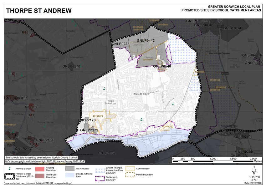
Settlement Name: Thorpe St. Andrew
Settlement       Thorpe St Andrew is classified as an urban fringe parish in
Hierarchy:       the Greater Norwich Local Plan and is within an area
                 identified for significant development as part of the Growth
                 Triangle Area Action Plan. The suburban character of
                 Thorpe St Andrew comprises mainly 20th Century semi-
                 detached and detached properties often set in large plots
                 with mature planting. The Thorpe St Andrew Conservation
                 Area extends northwards from the River Yare up the valley
                 side to the top of Thorpe Ridge.

                    Thorpe St Andrew also benefits from a good range of
                    services and facilities, principally based around the district
                    centre at Pound Lane that is anchored by a Sainsbury
                    supermarket. There is primary school provision within the
                    town council area and Thorpe St Andrew High School has
                    approximately 1,700 students, including a sixth form.
                    Historically, Thorpe St Andrew developed along Yarmouth
                    Road parallel to the north bank of the River Yare. Historic
                    listed buildings line Yarmouth Road, including the Grade II*
                    Thorpe Hall and the ruins to the Church of St Andrew.

                    Early work in the ‘Towards a Strategy’ Document specifies
                    200 dwellings as an indicative figure for new allocations in
                    north-east sector which includes Rackheath, Sprowston and
                    Thorpe St Andrew. This site assessment booklet looks in
                    detail at the sites promoted in Thorpe St Andrew to
                    determine which are the most suitable to contribute towards
                    the overall allocation figure for the sector.

                    There are no carried forward allocations but a total of 354
                    additional dwellings with planning permission at the base
                    date of the plan.

                                                                                     1
PART 1 - ASSESSMENTS OF SITES INCLUDED IN THE DRAFT
LOCAL PLAN REGULATION 18C CONSULTATION (JANUARY –
MARCH 2020)
STAGE 1 – COMPLETE LIST OF SITES PROMOTED IN THE SETTLEMENT
LIST OF SITES TO BE CONSIDERED FOR RESIDENTIAL/MIXED USE
ALLOCATION (0.5 HECTARES OR LARGER)
Address Site Reference Area (ha) Proposal
Thorpe St. Andrew
Land to the East side of GNLP0228 10.48 Mixed use
Woodside Road. (Thorpe (unspecified number)
Woodland) (provides links to
Woodside Road to
development to north-
east of the site)
Racecourse Plantations, GNLP0442 70.22 10ha for up to 330
Plumstead Road East dwellings with
remainder of the site
designed as a
community woodland
park
Oasis Sport & Leisure GNLP0540 3.03 Redevelopment of
Centre, 4 Pound Lane Oasis Leisure Club
including Erection of
Replacement Spa and
Wellbeing Club and
erection of 27
residential dwellings
Langley North GNLP2170 1.33 40 dwellings
Langley South GNLP2171 4.38 70 dwellings
Total area of land 89.44
LIST OF SITES TO BE CONSIDERED AS SETTLEMENT BOUNDARY
EXTENSIONS (SETTLEMENT BOUNDARY PROPOSALS AND SITES LESS
THAN 0.5 HECTARES)
Address Site Reference Area (ha) Proposal
None
(Sites of less than 0.5ha are not considered suitable for allocation and therefore
have not been assessed in this booklet. These sites will be considered as part of a
reappraisal of settlement boundaries to be published with the Regulation 19
Submission version of the Plan).
2LIST OF SITES SUBMITTED FOR OTHER USES
Address Site Reference Area (ha) Proposal
None
(Sites submitted for other uses are considered in separate ‘Non-Residential’ Site
Assessment booklets and therefore have not been assessed in this booklet).
3STAGE 2 – HELAA COMPARISON TABLE
RESIDENTIAL/MIXED USE
Categories
neighbouring uses
Compatibility with
Utilities Capacity
Open Space and
ground stability
Contamination/
attractiveness
Biodiversity &
Infrastructure
Geodiversity
environment
townscapes
Transport &
Site access
landscapes
Flood Risk
Significant
Access to
Sensitive
services
Historic
Utilities
Market
Roads
GI
Site
Reference
Thorpe St Andrew
GNLP0228 Amber Green Green Green Green Green Green Amber Amber Red Green Amber Green Green
GNLP0442 Amber Green Green Green Green Green Green Amber Amber Red Amber Amber Amber Green
GNLP0540 Green Green Green Green Green Green Green Amber Green Green Green Green Green Green
GNLP2170 Green Green Amber Green Amber Green Green Amber Amber Amber Green Green Green Green
GNLP2171 Green Green Amber Green Amber Green Green Amber Amber Amber Amber Green Green Green
4STAGE 3 – SUMMARY OF COMMENTS FROM THE REGULATION 18 STAGE A & B
CONSULTATIONS
Site Comments
Reference
Thorpe St Andrew
GNLP0228 Friends of Thorpe Woodlands
Opposed to any plans that will negatively impact on the wildlife that
depends on this woodland. It is a designated CWS and so should be
protected for future generations. The green corridor is overused and
so every effort should be made to extend the green spaces as the
population grows. The woods are designated as Ancient Woodland
and are important for ecology.
Norfolk Wildlife Trust
0228 and 0442: Pleased to see that the impact on CWS 2041 and GI
corridor seen as a major constraint and that all sites proposed will
have an adverse impact. These sites should not be allocated.
GNLP0442 Friends of Thorpe Woodlands
Opposed to any plans that will negatively impact on the wildlife that
depends on this woodland. It is a designated CWS and so should be
protected for future generations. The green corridor is overused and
so every effort should be made to extend the green spaces as the
population grows. The woods are designated as Ancient Woodland
and are important for ecology. The Technical Ecology Report for the
site demonstrated that the proposal would create ecological benefits.
Norfolk Wildlife Trust
0228 and 0442: Pleased to see that the impact on CWS 2041 and GI
corridor seen as a major constraint and that all sites proposed will
have an adverse impact. These sites should not be allocated.
Great and Little Plumstead Parish Council
The Parish Council objects. The destruction of woodland should not
be allowed to happen, this is a well-used site for walks etc. This site
allocation does not comply with Policy 1 of our Neighbourhood Plan.
GNLP0540 No comments submitted
(This site was given planning permission at the time of consultation)
GNLP2170 Barton Wilmore
Support - Whilst we note that some potential constraints have been
identified in respect of these sites, we do not believe that these are
significant constraints, and as identified in the HELAA Addendum,
initial discussions between Berliet and the Norfolk County Council
Highways team have established that both sites have satisfactory
access arrangements. We support the identification of these sites in
the emerging GNLP. We believe that they represent a sustainable
option for the identification of housing land supply within Broadland
District and the wider Greater Norwich area. See full report.
5Both the Pinebanks and Griffin Lane sites are sustainable sites on
which the principle of residential development has already been
accepted, and which present the opportunity to deliver additional
units to assist Broadland District Council in achieving their 5YHLS. It
is our view that the additional capacity available at both sites should
also be considered in the HELAA, alongside that of the Langley North
and Langley South sites.
Norfolk FA
Support - residential development in Thorpe St Andrew, on the
proviso S106 contributions are considered to support the
development of existing football facilities situated in the town.
Sport England
Object - To satisfy Sport England policy and meet Para 97 of the
NPPF, any development of the site would need to meet the following
criteria:
Exception 4
The area of playing field to be lost as a result of the proposed
development will be replaced, prior to the commencement of
development, by a new area of playing field:
* of equivalent or better quality, and
* of equivalent or greater quantity, and
* in a suitable location, and
* subject to equivalent or better accessibility and management
arrangements.
GNLP2171 Barton Wilmore
Support - Whilst we note that some potential constraints have been
identified in respect of these sites, we do not believe that these are
significant constraints, and as identified in the HELAA Addendum,
initial discussions between Berliet and the Norfolk County Council
Highways team have established that both sites have satisfactory
access arrangements. We support the identification of these sites in
the emerging GNLP. We believe that they represent a sustainable
option for the identification of housing land supply within Broadland
District and the wider Greater Norwich area. See full report.
Both the Pinebanks and Griffin Lane sites are sustainable sites on
which the principle of residential development has already been
accepted, and which present the opportunity to deliver additional
units to assist Broadland District Council in achieving their 5YHLS. It
is our view that the additional capacity available at both sites should
also be considered in the HELAA, alongside that of the Langley North
and Langley South.
Norfolk Football Association
Support – Residential development on the proviso S106 contributions
are considered to support the development of existing football
facilities situated in the Town.
6STAGE 4 – DISCUSSION OF SUBMITTED SITES
In this section sites are assessed in order to establish whether they are
suitable for allocation. For the purposes of Sustainability Appraisal, suitable
sites are those which are considered to be Reasonable Alternatives. Sites not
considered suitable for allocation are not realistic options and therefore are
not considered to be reasonable alternatives. The discussion below outlines
the reasons why a site has been deemed suitable or unsuitable for allocation.
By association this is also the outline of the reasons why a site was deemed to
be a reasonable or unreasonable alternative.
A range of factors have been taken into account to establish whether a site
should, or should not, be considered suitable for allocation. These factors
include: impact on heritage and landscape; impact on the form and character
of the settlement; relationship to services and facilities; environmental
concerns, including flood risk; and, in particular, a safe walking route to a
primary school. Sites which do not have a safe walking route to school, or
where a safe walking route cannot be created will not be considered suitable
for allocation.
Conclusions in regard to a sites performance against the relevant factors have
also been informed by the outcomes of the HELAA, as set out under stage 2,
consultation responses received, as summarised in stage 3, and other relevant
evidence.
Five sites have been submitted for the consideration of future development. Taking
account of the comments received, existing commitment, achieving safe access to
school, and subject to overcoming constraints set out in the HEELA including those
highlighted below, as well as recent appeals decisions the following sites could be
considered as reasonable alternatives:
GNLP0442
Racecourse Plantations, Plumstead Road East is proposed for up to 330 dwellings
with the remainder of the site designated as a community woodland park. The site
comprises mature woodland known as Racecourse Plantation and forms part of
Thorpe Woodland County Wildlife Site, an important green infrastructure corridor and
landscape feature in the area. Norfolk Wildlife Trust and Norfolk County Council
Ecology have stressed the importance of this site as a GI corridor in the wider
Greater Norwich GI Strategy and have advised against allocating it for development.
Other constraints include the potential loss of informal open space as well as visual
amenity, although site is privately owned and sections of surface water flood risk to
the south of the site. The site is well related to services and the form and character
of the area and was allowed on appeal in January 2019 (20168996) for 300 homes
and the creation of a new Community Woodland Park. It is therefore considered to
be a reasonable alternative.
7GNLP0540
The Oasis Sport and Leisure Centre has been promoted for redevelopment including
a replacement spa and wellbeing club and erection of 27 dwellings including
affordable. The site is within the settlement limit for Thorpe St Andrew where
development is acceptable in principle providing it does not result in any significant
adverse impact. The site is considered to be a reasonable alternative given the
recent appeal decision in February 2017 (20151132).
GNLP2170
This site at Langley North comprises the former Langley School and Pinebanks
playing fields and is promoted for 40 dwellings. The site is within the settlement limit
for Thorpe St Andrew where development is acceptable in principle provided that it
does not result in any significant adverse impact. The site is wedged between the
Conservation Area and a scheduled ancient monument to the east. In terms of
access, the land is under the same control as the Pinebanks site to the east (TSA2
allocation) from which vehicular access is proposed. Constraints include the
potential loss of playing fields which may require replacement. In addition, there are
physical constraints on site that may limit the development potential. This includes
the likely removal of hard standings, management of surface water risk, ground
investigations and utilities improvements. Whilst not prohibitive to the principle of
development the context of the site includes landscape impacts southwards towards
the River Yare and proximity of the site to the Conservation Area and the Broads
Authority area. Sport England has objected to the site stating that the area of
playing field to be lost as a result of the development should be replaced prior to the
commencement of development. The Football Association has supported the site on
proviso S106 contributions are considered to support the development of existing
football facilities situated in the town. In conclusion subject to overcoming the
constraints identified including Sport’s England objection this site is considered a
reasonable alternative.
GNLP2171
This site includes the former Langley Preparatory School and is located within the
settlement limit for Thorpe St Andrew where development in principle is acceptable
provided it does not result in any significant adverse impact. It is also within a
conservation area characterised by mature woodland in parts, nearly half of the site
is Ancient Woodland* as it forms part of a wooded ridge with landscape impacts
southwards towards the River Yare which is visible across the wider area. Therefore,
development at this location must not erode this character nor result in the loss or
deterioration of habitats. Access is proposed via Yarmouth Road, as previously
used by the Langley School, and there are no obvious highway concerns. Other
constraints include surface water flooding, potential impacts to grade II listed
buildings and heritage assets, utilities improvements, ground investigations and
proximity to the Broads administrative area. Subject to overcoming the constraints
identified including the preservation of ancient woodland surrounding the site is
considered a reasonable alternative.
*Half of the site is Ancient Woodland (not mentioned in the HELAA) *
8The site not considered as a reasonable alternative is:
GNLP0228
Land to the east side of Woodside Road is proposed for mixed use. The site
comprises mature woodland known as Thorpe Woodland a County Wildlife Site that
forms an important green infrastructure corridor and landscape feature in an area
expected to provide significant growth. Norfolk Wildlife Trust and Norfolk County
Council Ecology have stressed the importance of this site as part of a GI corridor in
wider Greater Norwich GI Strategy and have advised against allocating it for
residential development. Friends of Thorpe Woodland object on the grounds of the
importance of CWS, ecology and usage as informal open space. Despite the main
constraints of ecological impacts and potential loss of informal open space the site is
well related to services and the character of the area. Other constraints include
surface water flooding to the south of the side which might limit the developable
area. In conclusion, it is felt that in order to protect and enhance biodiversity there
may be other sites which are preferable to this site which does not involve loss of
county wildlife site and have less ecological and biodiversity impacts therefore this is
not a reasonable alternative.
9STAGE 5 – SHORTLIST OF REASONABLE ALTERNATIVE SITES FOR
FURTHER ASSESSMENT
Based on the assessment undertaken at stage 4 above the following sites are
considered to be reasonable alternatives.
Address Site Reference Area (ha) Proposal
Thorpe St Andrew
Racecourse GNLP0442 70.22 / 10ha* for up to 330
Plantations, Plumstead (10)*Res dwellings with remainder
Road East of the site designed as a
community woodland
park
Allowed on Appeal
Oasis Sport & Leisure GNLP0540 3.03 Redevelopment of Oasis
Centre, 4 Pound Lane Leisure Club including
Erection of Replacement
Spa and Wellbeing Club
and erection of 27
residential dwellings
Allowed on Appeal
Langley North (former GNLP2170 1.33 40 dwellings
playing fields/ Langley
school)
Langley South (former GNLP2171 4.38 70 dwellings
Langley School
Total area of land 18.74
(60.22
community
woodland
park)
10STAGE 6 – DETAILED SITE ASSESSMENTS OF REASONABLE ALTERNATIVE
SITES
Site Reference: GNLP0442
Address: Racecourse Plantations, Plumstead Road East
Proposal: 10ha* for up to 330 dwellings with remainder of the site
designed as a community woodland park
CURRENT USE OF SITE: BROWNFIELD/GREENFIELD:
Commercial forestry plantation with Greenfield
areas for paintballing and archery
CONSTRAINTS IDENTIFIED IN THE HELAA
Amber Constraints in HELAA
Access, Significant Landscapes, Townscapes, Historic Environment, Open Space
and GI, Transport and Roads
Red Constraints in HELAA
Biodiversity and Geodiversity
HELAA Conclusion
The site is greenfield land known as Racecouse Plantation, though forms part of
Thorpe Woodland off Plumstead Road it is well related to services and the
character of the area. It is a county wildlife site that forms an important green
infrastructure corridor and landscape feature to the area. Norfolk Wildlife Trust and
Norfolk Ecology have advised against allocating this site, therefore this is
considered a significant constraint. Initial highway evidence has indicated has
advised that there are potential access constraints on the site, but these could be
overcome through development and impact on road network could be reasonably
mitigated. There are no concerns over potential contamination, or impact to
heritage assets. However, other constrains include the potential loss of informal
open space as well as visual amenity, although privately owned, sections at risk of
surface water flooding, Abattoir located on part of site. There are number of
constraints but as these may be possible to mitigate the site is concluded as
suitable for the land availability assessment.
FURTHER COMMENTS
Highways
Yes, subject to acceptable access strategy and provision of frontage footway /
pedestrian/cycle links. (330 dwellings)
Development Management
PP granted on appeal under 20161896 for 300 dwellings and community woodland
park therefore no further assessment provided. Noted that 0228 has not been
shortlisted however given the appeal decision where the Inspector found no harm
11this may be difficult to justify if the proposal followed a similar ethos to the appeal
proposal?
Minerals & Waste
The site is underlain by a defined Mineral Safeguarding Area for sand and gravel.
Any future development on this site will need to address the requirements of
Norfolk Minerals and Waste Core Strategy Policy CS16 - ‘safeguarding’ (or any
successor policy) in relation to mineral resources, to the satisfaction of the Mineral
Planning Authority.
Lead Local Flood Authority
Mitigation required for heavy constraints. Significant information required at
planning stage. This allocation comprises three separate plots with different risk
associated with them. The south-eastern plot is mostly free from flood risk the
exception being small incursions in the 0.1% event on the southern boundary. The
site is not near a mapped watercourse, but the location on the edge of an existing
residential area suggests that sewer connections may be available. If not then
surface water drainage will be reliant on the results of infiltration testing. The south
western plot is bisected by a flow path in the 0.1% event which connects areas of
ponding that occur in the 1% event. Mapping also indicates the potential for two
additional flow paths to form perpendicular to the first. Any planning application
should be supported by modelling to understand the risk posed by the surface
water flow paths so that development can take place within increasing risk on or
off site. The site is not near a mapped watercourse, and the location on the edge
of the existing residential area suggests that sewer connections may not be
available. If not surface water drainage will be reliant on the results of infiltration
testing, which can be variable in this location. The northern plot is also shown on
mapping to be affected by a flow path in the 0.1% event, this bisects the southwest
corner. Any planning application should be supported by modelling to understand
the risk posed by the surface water flow paths so that development can take place
within increasing risk on or off site. The site is not near a mapped watercourse,
and the location on the edge of the existing residential area suggests that sewer
connections may not be available. The LLFA have been consulted on a planning
application for this northern plot and have raised an objection based on insufficient
information being provided to demonstrate that the site can manage surface water
without increasing flood risk.
PLANNING HISTORY:
Not known
BRIEF SUMMARY OF PLANS/DOCUMENTS PROVIDED WITH THE
SUBMISSION
• Supporting Briefing
• Detailed Representation
12Site Reference: GNLP0540
Address: Oasis Sport & Leisure Centre, 4 Pound Lane
Proposal: Redevelopment of Oasis Leisure Club including Erection
of Replacement Spa and Wellbeing Club and erection of
27 residential dwellings
CURRENT USE OF SITE: BROWNFIELD/GREENFIELD:
Part Sport & Leisure Centre with the Mainly Brownfield
remaining land garden to Tawny
Lodge & Beech Lodge
CONSTRAINTS IDENTIFIED IN THE HELAA
Amber Constraints in HELAA
Significant Landscapes
HELAA Conclusion
The site is currently known as Oasis Sport & Leisure Centre off Pound Lane and
has been allowed on appeal for redevelopment of spa and 27 dwellings. All
constraints are being mitigated. The site is subject to an existing planning
permission or allocation for a similar form of development, consequently it will not
contribute any additional development capacity for the purposes of the HELAA
analysis.
FURTHER COMMENTS
Highways
Yes. Consent granted at appeal (27 dwellings)
Minerals & Waste: The site is underlain by a defined Mineral Safeguarding Area
for sand and gravel. Any future development on this site will need to address the
requirements of Norfolk Minerals and Waste Core Strategy Policy CS16 -
‘safeguarding’ (or any successor policy) in relation to mineral resources, to the
satisfaction of the Mineral Planning Authority.
Development Management
Granted on appeal for proposed use (spa and 27 dwellings) however recently
permission has been given for a C2 care village on northern part of allocation -
have the owners aspirations now changed and should allocation reflect latest
permission/aspirations.
Lead Local Flood Authority
Few or no constraints. Standard information required at planning stage. RoFSW
mapping indicates that the site is generally at low risk of surface water flooding,
however a narrow surface water flow path passes through the middle of the site in
a 0.1% event at a mapped depth of 0.15m with isolate pockets up to 0.6m in
depth. Any planning application should be supported by robust information to
13demonstrate how this flow path will be managed without increasing flood risk. The
site is not near a mapped watercourse but the location adjacent to an existing
urban area suggests that sewerage connections may also be available.
PLANNING HISTORY:
20190016 / 20151132
PP granted for care village (C2). 20151132 - pp granted on appeal for health
club and 27 dwellings
BRIEF SUMMARY OF PLANS/DOCUMENTS PROVIDED WITH THE
SUBMISSION
No additional documents submitted to support this proposal.
14Site Reference: GNLP2170
Address: Langley North (former playing fields/Langley School)
Proposal: 40 dwellings
CURRENT USE OF SITE: BROWNFIELD/GREENFIELD:
Former Preparatory School Brownfield
CONSTRAINTS IDENTIFIED IN THE HELAA
Amber Constraints in HELAA
Utilities Capacity, Contamination and Ground Stability, Significant Landscapes,
Townscapes, Biodiversity and Geodiversity
HELAA Conclusion
This is a 1.33 ha site for 40 homes on land previously used as playing fields by the
Langley Preparatory School in Thorpe St Andrew. The Langley Preparatory School
land is under the same control as the Pinebanks site to the east from which
vehicular access is proposed. Initial Highway Authority evidence has not raised
any in principle concerns, subject to further details being provided. The site is in a
sustainable location and so the main considerations are physical constraints on
site that may limit the development potential. These factors are likely to include
removal of hard standings, management of surface water flood risk, ground
investigations, and utilities improvements. Whilst not prohibitive to the principle of
development, the context of the site includes landscape impacts southwards
towards the River Yare and the proximity of the site to the Thorpe St Andrew
Conservation Area. As well as being next to woodland, ecological constraints
relate to the site’s proximity to habitats in the Broads. The site is 300 metres from
the Broads Authority administrative area and within the 3,000 metre buffer
distance to SAC (Special Area of Conservation), SPA (Special Protection Area),
SSSI (Sites of Special Scientific Importance), Ramsar and National Nature
Reserve designations. In conclusion, the site is suitable for the land availability
assessment.
FURTHER COMMENTS
Highways
Yes, subject to acceptable access strategy and provision of pedestrian/cycle links.
(40 dwellings)
Minerals & Waste: The site is underlain by a defined Mineral Safeguarding Area
for sand and gravel. As the site is under 2 hectares it is exempt from the
requirements of Norfolk Minerals and Waste Core Strategy Policy CS16 –
‘safeguarding’, in relation to mineral resources. If the site area is amended in the
future to make the area over 2 hectares CS16 (or any successor policy) will apply.
Development Management
15The sites are within the settlement limits so do we need to allocate? At this stage I
am not convinced estate scale development could be delivered or the number of
dwellings which would be acceptable given the constraints - would an allocation be
'open ended' in terms of numbers or would it need to specify a range? However,
allocation could give greater strength for the need to masterplan/design code etc?
Lead Local Flood Authority
No comments
PLANNING HISTORY:
Not known
BRIEF SUMMARY OF PLANS/DOCUMENTS PROVIDED WITH THE
SUBMISSION
No additional documents submitted to support this proposal.
16Site Reference: GNLP2171
Address: Langley South (former Langley School)
Proposal: 70 dwellings
CURRENT USE OF SITE: BROWNFIELD/GREENFIELD:
Former Preparatory School Brownfield
CONSTRAINTS IDENTIFIED IN THE HELAA
Amber Constraints in HELAA
Utilities Capacity, Contamination and Ground Stability, Significant Landscapes,
Townscapes, Biodiversity and Geodiversity, Historic Environment
HELAA Conclusion
This is a 4.38 ha site for 70 homes on land previously used by the Langley
Preparatory School. Access is proposed via Yarmouth Road, as previously used
by the Langley School, and initial Highway Authority evidence has raised no
objection. The site is in a sustainable location and so the main considerations are
physical constraints on site that may limit the development potential. These factors
are likely to include removal of existing buildings and hard standings, management
of surface water flood risk, ground investigations, and utilities improvements.
Whilst not prohibitive to the principle of development, the context of the site
includes landscape impacts southwards towards the River Yare and the proximity
of the site to the Thorpe St Andrew Conservation Area. As well as being next to
woodland, ecological constraints relate to the site’s proximity to habitats in the
Broads. The site is 100 metres from the Broads Authority administrative area and
within the 3,000 metre buffer distance to SAC (Special Area of Conservation), SPA
(Special Protection Area), SSSI (Sites of Special Scientific Importance), Ramsar
and National Nature Reserve designations. In conclusion, the site is suitable for
the land availability assessment.
FURTHER COMMENTS
Highways
Yes, subject to acceptable access strategy and provision of pedestrian/cycle links.
(70 dwellings)
Development Management
The sites are within the settlement limits so do we need to allocate? At this stage I
am not convinced estate scale development could be delivered or the number of
dwellings which would be acceptable given the constraints - would an allocation be
'open ended' in terms of numbers or would it need to specify a range? However,
allocation could give greater strength for the need to masterplan/design code etc?
Minerals & Waste
17The site is underlain by a defined Mineral Safeguarding Area for sand and gravel.
Any future development on this site will need to address the requirements of
Norfolk Minerals and Waste Core Strategy Policy CS16 - ‘safeguarding’ (or any
successor policy) in relation to mineral resources, to the satisfaction of the Mineral
Planning Authority.
Lead Local Flood Authority
No comments
PLANNING HISTORY:
Not known
BRIEF SUMMARY OF PLANS/DOCUMENTS PROVIDED WITH THE
SUBMISSION
No additional documents submitted to support this proposal.
18STAGE 7 – SETTLEMENT BASED APPRAISAL OF REASONABLE ALTERNATIVE
SITES AND IDENTIFICATION OF PREFERRED SITE/S (WHERE APPROPRIATE) FOR
REGULATION 18C DRAFT PLAN CONSULTATION.
Four reasonable alternative sites have been identified in Thorpe St Andrew at stage
5 of this booklet. These sites were considered to be worthy of further investigation to
look at their potential for allocation as the initial assessment did not flag up any major
constraints that would preclude development. These sites have been subject to
further discussion with Development Management, Highways, Flood Authority and
Children’s Services in order to identify preferred sites for allocation and their
comments are recorded under stage 6 above.
Thorpe St Andrew is an Urban Fringe parish, in the north-east sector. The Towards a
Strategy Document specifies 200 dwellings as an indicative figure for new allocations
in north-east sector. Through further discussion of shortlisted sites, there are no
preferred sites in Thorpe St Andrew. It is considered that there is no reasonable
alternative to this approach.
Sites GNLP0442 and GNLP0540 have been granted permission on appeal, and will
therefore be counted in commitments for the local plan. It would not be acceptable to
also count them as an allocation.
Sites GNLP2170 and GNLP2171 have been dismissed on highway and ecological/
landscape grounds.
In conclusion there are no sites identified as preferred options in Thorpe St
Andrew. There are no carried forward allocations but a total of 354 additional
dwellings with planning permission. This gives a total deliverable housing
commitment for Thorpe St Andrew of 354 homes between 2018 – 2038.
Preferred Sites:
Address Site Area Proposal Reason for allocating
Reference (Ha)
Thorpe St Andrew
NO PREFERRED SITES
Reasonable Alternative Sites:
Address Site Area Promoted for Reason for not allocating
Reference (ha)
Thorpe St Andrew
NO REASONABLE ALTERNATIVE SITES
19Unreasonable Sites:
Address Site Area Promoted for Reason considered to be
Reference (ha) unreasonable
Thorpe St Andrew
Land to the GNLP0228 10.48 Mixed use This site is considered to
East side of (unspecified number) be unreasonable for
Woodside (provides links to allocation as there are
Road Woodside to other more preferable sites
(Thorpe development to north to consider which do not
Woodland) east of the site) involve the loss of a county
wildlife site and which have
less ecological and
biodiversity impacts. This
site also has issues with
surface water flood risk.
Racecourse GNLP0442 70.22 10 ha for up to 330 This site is well related to
Plantations, dwellings with services and the form and
Plumstead remainder of the site character of the area. It
Road East designated as a was allowed on appeal in
community wood January 2019 (reference
land park 20168996) for 300 homes
and the creation of a new
Community Woodland
Park, so it is not proposed
to allocate the site in the
local plan.
Oasis Sport GNLP0540 3.03 Redevelopment of This site is within the
and Leisure Oasis Leisure Club settlement limit where
Centre, 4 including erection of development is acceptable
Pound Lane replacement spa and in principle providing it
wellbeing club and does not result in any
erection of 27 significant adverse impact.
residential dwellings The site was granted on
appeal in February 2017
(reference 20151132) so it
is not proposed to allocate
the site in the local plan.
Langley GNLP2170 1.33 40 dwellings This site is within the
North (former settlement limit where
playing development is acceptable
fields/Langley in principle providing it
School) does not result in any
significant adverse impact.
Sport England has objected
stating that the area of
playing field to be lost as a
result of development
should be replaced prior to
commencement. The site
20Address Site Area Promoted for Reason considered to be
Reference (ha) unreasonable
is considered to be
unsuitable for allocation, as
site constraints prevent
formation of an acceptable
vehicular access.
Langley GNLP2171 4.38 70 dwellings This site is within the
South (former settlement limit where
Langley development is acceptable
School) in principle providing it
does not result in any
significant adverse impact.
Half of the site is Ancient
Woodland which is a
significant constraint. The
site is considered to be
unsuitable for allocation, as
site constraints prevent
formation of an acceptable
vehicular access.
21PART 2 - SUMMARY OF COMMENTS FROM THE REGULATION 18C DRAFT PLAN CONSULTATION
STRATEGY QUESTION: Site GNLP0442
SETTLEMENT/ SITE REFERENCE: Racecourse Plantations, Plumstead Road East, Thorpe St Andrew
(Unreasonable Residential Site)
TOTAL NUMBER OF 1
REPRESENTATIONS:
SUPPORT/ OBJECT/ COMMENT 1 Support, 0 Object, 0 Comment
BREAKDOWN:
RESPONDENT SUPPORT/ BRIEF SUMMARY OF MAIN ISSUES DRAFT GNLP PROPOSED
(OR GROUP OF OBJECT/ COMMENTS REQUIRING RESPONSE CHANGE TO
RESPONDENTS) COMMENT INVESTIGATION PLAN
Member of the Support Considered unreasonable This site was None
public as it’s a woodland that allowed under a
surround the East side of planning appeal by
Norwich independent
planning inspector.
However, it is not
proposed to
allocate the site in
the local plan.
22STRATEGY QUESTION: Site GNLP2170
SETTLEMENT/ SITE REFERENCE: Langley North (Former Playing Fields/Langley School), Thorpe St Andrew
(Unreasonable Residential Site)
TOTAL NUMBER OF 1
REPRESENTATIONS:
SUPPORT/ OBJECT/ COMMENT 0 Support, 1 Object, 0 Comment
BREAKDOWN:
RESPONDENT SUPPORT/ BRIEF SUMMARY OF MAIN ISSUES DRAFT GNLP PROPOSED
(OR GROUP OF OBJECT/ COMMENTS REQUIRING RESPONSE CHANGE TO
RESPONDENTS) COMMENT INVESTIGATION PLAN
Barton Willmore Object Site benefits from outline This site is not None
planning approval for allocated as it is
residential development, located within the
there is no evidence that settlement limit
development at this where development
location would result in is acceptable in
further deficiency of playing principle providing
pitches. See Full it does not result in
representation. any significant
adverse impact.
23STRATEGY QUESTION: Site GNLP2171
SETTLEMENT/ SITE REFERENCE: Langley South (Former Langley School), Thorpe St Andrew
(Unreasonable Residential Site)
TOTAL NUMBER OF 1
REPRESENTATIONS:
SUPPORT/ OBJECT/ COMMENT 0 Support, 1 Object, 0 Comment
BREAKDOWN:
RESPONDENT SUPPORT/ BRIEF SUMMARY OF MAIN ISSUES DRAFT GNLP PROPOSED
(OR GROUP OF OBJECT/ COMMENTS REQUIRING RESPONSE CHANGE TO
RESPONDENTS) COMMENT INVESTIGATION PLAN
Barton Willmore Site benefits from outline This site is not None
planning approval for allocated as it is
residential development, located within the
there is no evidence that settlement limit
development at this where development
location would result in is acceptable in
further deficiency of playing principle providing
pitches. See Full it does not result in
representation. any significant
adverse impact.
Half the site is
designated as
Ancient Woodland
which would affect
the developable
area.
24PART 3 - ASSESSMENT OF NEW & REVISED SITES SUBMITTED
DURING THE REGULATION 18C CONSULTATION
No new or revised sites submitted through the Regulation 18C consultation.
FINAL CONCLUSIONS FOR THE REGULATION 19 VERSION OF
THE PLAN
Site assessments prior to the Regulation 18C consultation
Up to the Regulation 18C consultation there were 5 sites promoted for
residential/mixed use totalling 89.44 hectares of land. The outcome of initial site
assessment work (which is detailed in part 1 of this booklet) was not to prefer any
sites for allocation in Thorpe St Andrew and this was the option that was consulted
on during the Regulation 18C consultation. The sites promoted were considered to
be unsuitable for allocation for a variety of reasons including ecological and
biodiversity impacts, access and existing planning permissions on sites within the
settlement limi.t
Summary of comments from the Regulation 18C draft plan consultation
Through the Regulation 18C consultation a number of comments were received
regarding sites in Thorpe St Andrew (detailed in part 2 above). The main comments
received were objections from the promoter regarding the non allocation of sites at
Langley North and South and support for the non allocation of the site at Racecourse
Plantations from a member of the public. These comments have been given due
consideration but no change is proposed to the decision not to allocate any sites in
Thorpe St Andrew.
Assessment of new and revised sites submitted through the Regulation 18 C
consultation
No new or revised sites submitted through the Regulation 18C consultation.
Sustainability Appraisal
The sustainability performance of each reasonable alternative site has been
considered in the selection of sites. The Sustainability Appraisal includes a scoring
and assessment narrative on the sustainability performance of each reasonable
alternative and recommendations for mitigation measures which have been
incorporated in policy requirements as appropriate. The Sustainability Appraisal
(insert link) highlighted a number of negative and a few positive impacts for the sites
in Thorpe St Andrews which support the decision not to allocate any sites.
25Final conclusion on sites for allocation in the Regulation 19 Plan
Based on all the information contained within this booklet the final conclusion of the
site assessment process for Thorpe St Andrews is not to allocate any sites in the
plan.
See tables of allocated and unallocated sites at appendices A and B for the full list of
sites promoted with reasons for allocation and rejection.
2627
You can also read