Welcome Bay and Ohauiti Planning Study 2020 - APPENDIX 6: STORMWATER ASSESSMENT - Tauranga City ...
←
→
Page content transcription
If your browser does not render page correctly, please read the page content below
Welcome Bay
and Ohauiti
Planning Study
2020

APPENDIX 6: STORMWATER ASSESSMENT
Welcome Bay and Ohauiti Planning
            Study
    Stormwater Assessment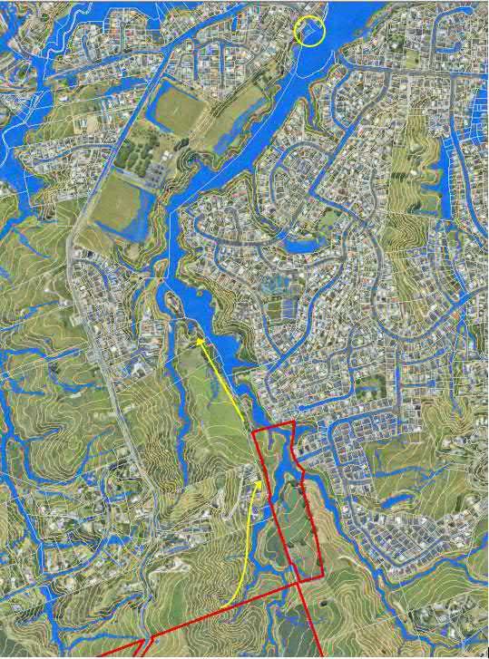
Contents
 1.     Introduction ..................................................................................................................2
      1.1     Background ..........................................................................................................3
      1.2     Stormwater management philosophy ....................................................................3
      1.3     Assumptions .........................................................................................................3
 2.     Areas of investigation...................................................................................................4
      2.1     Area 1 - Ohauiti.....................................................................................................4
      2.2     Area 2 – Kaitemako Road .....................................................................................5
      2.3     Area 3 – Eagle Street............................................................................................5
      2.4     Area 4 – Ranginui Road........................................................................................5
      2.5     Area 5 – Welcome Bay to Ngapeke Road .............................................................6
      2.6     Area 6 – Welcome Bay Road South......................................................................6
      2.7     Area 7 – Waikite Road ..........................................................................................6
 3.     Stormwater considerations ..........................................................................................7
      3.1     Receiving environments........................................................................................7
      3.2     Existing downstream flooding issues ....................................................................7
      3.3     Downstream infrastructure ..................................................................................11
      3.4     Consents ............................................................................................................13
 4.     Infrastructure considerations for growth areas ...........................................................14
      4.1     Internal development area ..................................................................................14
      4.2     Public external infrastructure...............................................................................15
      4.3     Summary ............................................................................................................16
 5.     Recommendations for further work ............................................................................17
 Appendix A – Area maps ..................................................................................................18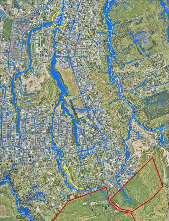
Executive Summary
This initial investigation as part of the Welcome Bay Ohauiti Planning Study outlines existing
and future stormwater constraints that should be considered if further growth is to be
provided within the Study Area.
There are evolving requirements around stormwater management that inform planning for
infrastructure and new growth areas. These include a new National Policy Statement for
Freshwater Management, three waters and Resource Management Act reform proposals, an
upcoming City Plan review, proposed dam safety regulations and climate change guidance
for local government. This means that stormwater infrastructure needs within and outside of
growth areas may also evolve over the course of development planning.
Key stormwater considerations for growth scenarios are water quality treatment, flood hazard
within and without development areas, and downstream infrastructure.
In the Study Area (which is characterised by streams flowing into Te Awanui Tauranga
habour) downstream infrastructure commonly includes road embankments and culverts.
Roads acting as large dams will be subject to assessment and, if required, remedial works
under the proposed regulatory framework for dam safety. Further growth in the Study Area
may influence requirements and costs beyond the business as usual growth scenario.
The Study Area includes land at risk of flooding. This risk is expected to worsen with climate
change increasing sea level rise and rainfall intensity. Council’s flooding Level of Service
(LoS) is based on a ‘safety to persons’ approach and the LOS programme includes multiple
areas in the Study Area under investigation. It is recommended that the Awaiti LoS project
downstream of investigation Area 1 be designed to cater for stormwater from this area
(identified in the medium and high growth scenarios).
Stormwater management within growth areas is intrinsically linked with development
landform and layout. Structure planning of future growth areas is required to coordinate
assessment and consideration of the receiving environment, ecological areas within the
development area, effects, natural hazards and stormwater infrastructure requirements as
part of development planning and consenting. This process will influence the development
landform, layout and yield.

1. Introduction
1.1   Background
Tauranga City Council (Council) is undertaking the Welcome Bay and Ohauiti Planning
Study (Study) to investigate the potential for accommodating further growth in these areas.
The Study stemmed from multiple proposals for Special Housing Areas in Welcome Bay and
Ohauiti. Given the range of issues facing this area it was considered inappropriate to
progress development proposals without first undertaking a comprehensive planning study.
Multiple investigations are proposed to assess the implications of, and requirements for,
development, including investigations into infrastructure capacity. The purpose of the
infrastructure capacity work is to understand the constraints and opportunities to upgrade
infrastructure and associated costs.
This assessment provides a high-level overview of the stormwater infrastructure needed to
accommodate additional urban growth in the Study Area and the opportunities and issues
associated with developing additional infrastructure.
1.2   Stormwater management philosophy
The key national directions under the Resource Management Act 1991 for freshwater
planning and management are the National Policy Statement for Freshwater Management
2014 and its proposed successor, the National Policy Statement for Freshwater Management
2020 (NPSFM).
The concepts and requirements of the NPSFM are implemented locally by regional, city and
district plans and policies. These necessitate an interdisciplinary “Water Sensitive Design”
(WSD) approach to stormwater management. WSD integrates consideration of site ecology,
urban design, earthworks and landform and the use of natural systems and processes into
stormwater design.
The effects of development on stormwater flows and any necessary mitigation measures are
integral to development assessments under policies and plans administered by Council and
the Bay of Plenty Regional Council. The effects of, and any mitigation measures associated
with, stormwater flows are assessed on a site- and locality-specific basis, considering the
downstream flood hazard, existing and future downstream land use and development and
the influence of upstream development.
Furthermore, protecting stream and receiving environment health is integral to compliance
with the NPSUD and a WSD approach to stormwater management. This requires the
assessment and management of development effects on stormwater quality, changes in
runoff response downstream, changes in flow regimes and potential subsequent effects of
stream erosion and sedimentation on waterways and the harbour.
Development concepts were not prepared for this high-level report. The comments in this
report are general and based on current landform This report would need to be further
developed as part of any future integrated development planning for additional urban growth
in the Study Area.
1.3   Assumptions
This report is based on a desktop review. It focuses on public infrastructure considerations
outside of the areas of investigation and comments on the potential implications of
development for stormwater management. It does not address internal infrastructure
requirements within potential development areas.
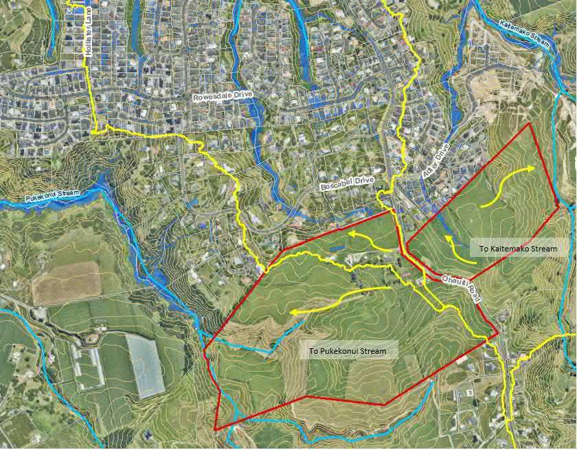
Stormwater infrastructure associated with any transportation upgrades or new infrastructure
identified in the parallel transportation assessment is not included in this report. The various
other technical assessments associated with the Welcome Bay and Ohauiti Planning Study
will need to be integrated at the next stage of assessment (if investigations are progressed).

2. Areas of investigation
Seven sub-precincts for investigation were identified, being land in the Rural Zone or Rural
Residential Zone in Tauranga City or in Western Bay of Plenty District Council adjoining the
common municipal boundary. Plans of each sub-precinct/investigation area are included in
Appendix A.

Figure 1 Sub-precincts for investigation in the Study Area

2.1    Sub-precinct 1 – Ohauiti Growth Area
Sub-precinct 1 encompasses land on both sides of Ohauiti Road, south of Boscabel Drive
and Adler Drive.
The westernmost portion of sub-precinct 1 includes areas in the Greenbelt Zone that
contribute to the Pukekonui Stream. This is a tributary of the larger Waimapu Stream which
flows north to the Waimapu estuary. The potentially developable area is elevated and the
streams are significantly lower than the surrounding land and are therefore unlikely to be
developable. This presents an opportunity to enhance the low-lying areas (which are
currently farmed) for amenity or biodiversity purposes. Aerial imagery indicates there may be
potential for groundwater seepage from these slopes which will require further investigation.
A small northern portion of the site flows through the neighbouring development at Boscabel
Drive to join the Waipapa (Ohauiti) Stream, also discharging to the Waimapu Estuary.
Land to the east of Ohauiti Road is within the Kaitemako Stream catchment. There is a flow
path through the neighbouring residential development along Parnwell Place and Adler
Drive. Kaitemako Stream flows to an estuary at Welcome Bay.

Figure 2 Indicative stormwater catchments of Area 1

2.2   Sub-precinct 2 – Kaitemako Road
Sub-precinct 2 is on either side of Kaitemako Road south of Panorama Drive.
The part of the site to the west of the road borders the Kaitemako Stream. It includes
ephemeral flow paths contributing to the stream and tributaries.
The land east of Kaitemako Road includes Otumanga Stream which flows through Johnson
Reserve to Welcome Bay.
Sub-precinct 2 is elevated with steep slopes down to the streams.
2.3   Sub-precinct 3 – Eagle Street
Sub-precinct 3 is downstream (north of) of the eastern part of sub-precinct 2. It includes the
confluence of Otumanga Stream and a tributary consisting of two unnamed streams which
then flow through the Johnson Wetland Reserve and into Welcome Bay.
2.4   Sub-precinct 4 – Ranginui Road
Sub-precinct 4 is around the Ranginui Road peninsula. It is bordered by Tauranga habour to
the north, Welcome Bay to the west and an unnamed stream discharging to Rangataua Bay
in the east. The land slopes steeply towards the stream, which forms the boundary between
sub-precincts 4 and 5. A network of flow paths conveys water from the peninsula to the
habour.
2.5   Sub-precinct 5 – Welcome Bay to Ngapeke Road
Sub-precinct 5 is a narrow area between Welcome Bay Road to the south and a stream to
Rangataua Bay (the boundary with sub-precinct 4). Sub-precinct 5 is intersected by several
flow paths and ephemeral waterways connecting to the stream. The northern end of the area
rises into a steep peninsula extending into Rangataua Bay. Storm tide inundation from the
harbour is predicted to extend up the stream into sub-precinct 5.
2.6   Sub-precinct 6 – Welcome Bay Road South
Sub-precinct 6 contains a central ephemeral stream which drains north towards Welcome
Bay Road. This flow enters sub-precinct 5 on the northern side of Welcome Bay Road and
the subsequent stream to the harbour.
2.7   Sub-precinct 7 – Waikite Road
Sub-precinct 7 is in the Western Bay of Plenty District at the southern extent of Waikite
Road. The site is on the eastern side of Waikite Road and south of Gunbar Drive. The land
includes a saddle with flow paths leading north to a stream through the Ranginui Road area
(including sub-precincts 4 and 5) and south to a stream through the Ngapeke area.
3. Stormwater considerations
3.1   Receiving environments
All of the sub-precincts are in catchments which discharge to Tauranga habour. There are
multiple Special Ecological Areas (SEA) associated with the downstream estuarine
environment, shown in Table 1. Planning policy objectives for the protection of these
freshwater environments must be considered in the development of growth areas.
Stormwater from the investigation areas may pass through overland flow paths (including
roads and reserves) or streams before entering the harbour. Where a discharge is directly to
a stream, the effects of the discharge on the stream health and erosion must be considered.
Table 1 Special Ecological Areas downstream of investigation areas

 Investigation area                     Mapped watercourse in        Downstream Special
                                        or adjacent to area          Ecological Area (City Plan)
 Sub-precinct 1 – Ohauiti               Pukekoni Stream              Waimapu Estuary
                                                                     Poike
                                        Kaitemako Stream             Kaitemako Stream Mouth
 Sub-precinct 2 - Kaitemako Road        Kaitemako Stream             Kaitemako Stream Mouth
                                                                     Welcome Bay
 Sub-precinct 3 – Eagle Street          Otumanga Stream and          Welcome Bay
                                        Unnamed tributary
 Sub-precinct 4 – Ranginui Road                                      Ranginui Road
                                        Unnamed stream               Ngapeke Road
 Sub-precinct 5 – Welcome Bay to        Unnamed stream               Ngapeke Road
 Ngapeke Road
 Sub-precinct 6 – Welcome Bay           Unnamed stream               Ngapeke Road
 South
 Sub-precinct 7 – Waikite Road                                       Ngapeke Road

3.2   Existing downstream flooding issues
Areas in Welcome Bay and Ohauiti are known or suspected to be susceptible to rainfall-
related flooding. Land close to Tauranga habour is also susceptible to flooding from storm
surge and sea level rise. Flooding can be expected to worsen over time as the effects of
climate change intensify. These issues exist in a business as usual growth scenario
regardless of any future urban growth in the Study Area.
Council’s current stormwater projects to investigate and potentially mitigate existing issues
are based on the defined Level of Service (LoS). The potential for future upstream
development should be taken into consideration when investigating these areas.
Outside of LoS investigations there are no Council projects to address existing issues.
Further planning will be required to assess whether development of these investigation areas
can and should mitigate downstream effects (to not worsen the existing situation), or,
whether upstream development provides an opportunity to undertake integrated planning to
address land use planning, infrastructure provision and resilience to natural hazards.
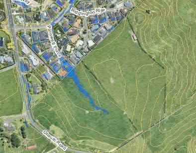
3.2.1         Level of Service
Council defines LoS for brownfield areas based on a “safety to persons” approach. The
criteria for assessing level of service deficiency is the product of depth and velocity in a 1%
AEP flood event. Areas of depth multiplied by velocity (D x V) greater than 0.4 m 2/s within 8
metres of an existing residential property do not meet the target Level of Service.
The following LoS issues are present downstream of the investigation areas.
Awaiti Place
A high depth and velocity combination exists at Awaiti Place where development has
occurred within the floodplain of the Waipapa Stream. This area is under investigation as part
of a programme to investigate LoS issues and potential solutions. Based on the current
landform, part of sub-precinct 1 adjacent to Boscabel Drive is in this contributing catchment.

Figure 3 Awaiti LoS project downstream of part of sub-precinct 1
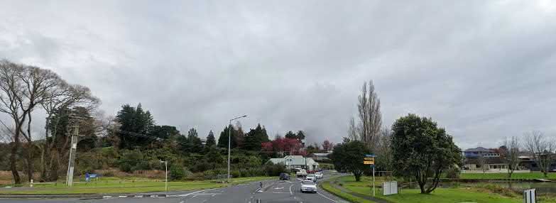
Welcome Bay Road
A high depth and velocity combination is under investigation at 166 Welcome Bay Road. This
property is downstream of sub-precincts 2 and 3. High depth and velocity is also expected to
affect the condition and function of Welcome Bay Road at this location.

Figure 4 166 Welcome Bay Road level of Service project downstream of Area 3 and part of Area 4

LoS investigations are also underway in Resolution Road and Esmeralda Street in Welcome
Bay. However, these are not in the same sub-catchments as any of the sub-precincts.
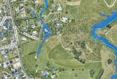
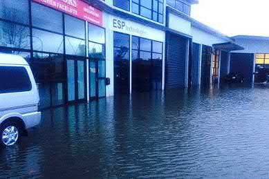
3.2.2         Known flood history
Land near the Waimapu Estuary, downstream of sub-precinct 1, is prone to flooding. The
low-lying land has been flooded in previous rainfall events, including flooding of properties on
Oropi Road and Roxanne Place. This land is also susceptible to sea level rise, associated
groundwater rise and storm-induced harbour inundation.

Figure 5 Roxanne Place (left) and Oropi Road (right) in 2014 floods (images: Sun Live)

The intersection of Welcome Bay Road and James Cook Drive is a localised low point and
has flooded previously, affecting traffic and the condition of the road. This can occur when
high tide levels prevent the road from draining. The road is also susceptible to sea level rise,
associated groundwater rise, storm-induced harbour inundation and flooding from the
Otumanga Stream in extreme rainfall. The Depth x Velocity LoS investigation at 166
Welcome Bay Road is adjacent to this road low point. This section of Welcome Bay Road is
downstream of sub-precincts 2 and 3.

Figure 6 Welcome Bay Road - James Cook Drive intersection at Johnson Wetland Reserve

3.2.3         Potential issues
In addition to recorded floods, inspection of the investigation areas and flood maps suggests
flood risk at residential and rural residential properties in Parnwell Place (adjoining sub-
precinct 1) and Gunbar Drive (adjoining sub-precinct 6).
Figure 7 Flowpath towards Parnwell Place - downstream of sub-precinct 1

Figure 8 Flowpath towards Gunbar Drive - downstream of sub-precinct 6

3.3     Downstream infrastructure
3.3.1        Road embankments acting as dams
Road embankments can be considered dams when they have potential to store water behind
them. A regulatory framework for dam safety is being progressed by the Ministry of Business,
Innovation and Employment. This will regulate dams considered as “classifiable” based on
height and potential storage volume. A dam is considered “classifiable” when the
embankment height is 4 m or greater and 20,000 m 3of water or more can be stored.
A preliminary desktop assessment has identified the following road embankments in the
Study Area as likely or potential “classifiable” dams under the proposed regulations.
Table 2 Possible dam infrastructure

 Area of investigation                Downstream classifiable             Upstream classifiable dam
                                      dam
                                      (height > 4 m and volume >
                                      20,000 m3)
 Sub-precinct 1 – Ohauiti*            McFetridge Lane                     -
                                      Rowesdale Drive (potential)
 Sub-precinct 2 - Kaitemako           Panorama Drive                      -
 Road
 Sub-precinct 3 – Eagle Street        -                                   -
Sub-precinct 4 – Ranginui - Oceana Drive (potential)
Road
Welcome Bay Road (potential)
Sub-precinct 5 – Welcome Bay - Oceana Drive (potential)
to Ngapeke Road
Welcome Bay Road (potential)
Sub-precinct 6 – Welcome Bay Welcome Bay Road -
South (potential)
Sub-precinct 7 – Waikite Road Oceana Drive (potential) -
Welcome Bay Road
(potential)
*State Highway 29A over the Waimapu Stream may also be considered a dam. This is a Waka Kotahi
NZ Transport Agency asset.
TCC will be required to undertake a programme of dam identification and classification and
for applicable dams, a Dam Safety Assurance Programme (DSAP). Budget is to be allocated
for the initial programme of assessment in the 2021-2031 Long Term Plan. Any resulting
works will then need to be identified and budgeted.
Any residential development capacity that the Study identifies upstream of these roads does
not necessarily place a new requirement upon TCC, as all potential dams will need to be
assessed as part of a future works programme. However, development proposals in the area
may trigger the need to assess and address existing dams downstream of the proposal site.
Increased stormwater runoff from land development upstream of embankments/dams could
trigger the need to assess and mitigate the impact of floods on the embankment.
The construction of new roads associated with additional urban growth in the Study Area will
need to assess the potential dam effects into design and consenting.
3.3.2 Infrastructure constraints
In addition to the above road dams and associated culverts, the following constraints were
identified as requiring further investigation.
Sub-precinct 1
Part of the western area of sub-precinct 1 slopes towards adjacent rural residential and
residential development (refer to Figure 2). The flow path through Boscabel Drive rural
residential development traverses private land and private ponds. There is also a reach
between McFetridge Lane and Awaiti Place where the waterway is in private ownership.
Private ownership of downstream flow paths and streams limits Council’s ability to consider
and mitigate the stormwater effects of upstream development. Further towards the habour,
flow paths are present along Awaiti Place and Harrisfield Drive Stormwater Reserve, which is
public land. However, the available space for stormwater management and treatment is
constrained by dwellings on both sides of the road and stormwater reserve.
To the east of Ohauiti Road, part of the land slopes towards Parnwell Place with resulting
flow paths along Parnwell Place and Adler Drive before stormwater enters the Kaitemako
Stream. Safety, including access, will need to be considered if increased flood flows or
durations are proposed on public roads.
Sub-precincts 1 and 2
Parts of sub-precincts 1 and 2 discharge to the Kaitemako Stream, which is bridged by
Welcome Bay Lane and Welcome Bay Road prior to entering the habour. The major culvertsrecently constructed as part of the key transport link to the Maungatapu Underpass have been designed to provide freeboard above the 1% AEP flood event. Capacity and effects at the bridges and culverts must be modelled in assessing upstream development proposals. Sub-precincts 5 and 6 An existing culvert at R366 Welcome Bay Road conveys water across the road from sub- precinct 6 into sub-precinct 5. However, flood maps also suggest that Welcome Bay Road is overtopped with significant depths of water in flood events. The land on either side of the culvert is private. It appears that the stream has been dammed on private property upstream (south of Welcome Bay Road) while the stream has also been obstructed downstream (north of Welcome Bay Road). Development in either area will require the conveyance function to be re-established to provide an effective stormwater system and cross-road drainage. 3.4 Resource consents Council holds a Comprehensive Stormwater Resource Consent (No. 66823) for the Tauranga City area. The extent of this consent encompasses land in Tauranga City. The consent authorises discharges from Council’s stormwater network. It does not authorise new discharges beyond the identified network. Any additional discharges will require a resource consent from the Bay of Plenty Regional Council (BoPRC). Development of the sub-precincts would therefore require resource consent from BoPRC for stormwater discharges and any associated damming and diversion activities. It is noted that while sub-precincts 1 to 6 are in the extent of the comprehensive stormwater consent, they are rural areas and are not serviced by Council’s existing stormwater network, and, there are few/no consented discharge points to land or water in these sub-precincts. Consequently, Council’s existing comprehensive stormwater consent would require amendment (or a separate consent would have to be obtained) to authorise the network extensions and any diversions or discharges required to service the investigation areas with stormwater infrastructure.
4. Infrastructure considerations for growth areas
4.1     Internal development area
4.1.1        Landform
Landform is key component for stormwater management. Development should take a WSD
approach to maintain natural systems and minimise disturbance.
Many of the investigation areas include steep slopes from developable land to existing
streams. The developed landform needs to convey water from elevated areas to low-lying
areas and manage discharge velocities and associated scouring and erosion of the receiving
environment. Stormwater management and earthworks in growth areas also need to ensure
slope stability. Stormwater infiltration close to a slope can cause instability and the formation
of springs. Setbacks for land stability may need to be established and incorporated into
structure plans for growth areas. The modification of slopes can also affect the flow of water
and spring location and this should be considered when assessing earthworks proposals.
4.1.2        Overland flow paths
The hilly topography conveys stormwater runoff via overland flow paths to the larger streams
and gullies. Space needs to be allowed within the development to either maintain these flow
paths or recreate them at an appropriate location.
Development should therefore be set back from high DxV areas to avoid exposing people
and property to flood hazard and to meet Council’s target LoS. Development also needs to
avoid causing new hazards created by concentrated flows.
Flow paths must accommodate flows from the 1% AEP rainfall event, taking into account
predicted climate change to the year 2130. The flows must be provided for on public land
within development areas, either in road corridors for flows with design safety limits, or for
larger flows, in dedicated reserve areas. This needs to be considered in development design.
4.1.3        Water quality treatment
The standard of water quality treatment to be provided in new developments will depend on
factors including the character of discharges and the downstream receiving environment(s).
Discharges to streams must achieve water quality standards set by discharge consents.
These standards may be informed by water quality targets in the NPSFM and the National
Environmental Standard for Freshwater.
The generation of urban stormwater contaminants can be reduced through material
selection. Development controls could seek to reduce contaminant generation by requiring
the use of inert materials, for example avoiding copper and zinc. A treatment train approach
to material section, source control and treatment of higher contaminant generating areas at
source can minimise the scale of required treatment devices prior to discharge points.
Specific water quality treatment is required for areas that generate elevated contaminant
levels, such as car parking areas with more than 25 spaces. At-source treatment by
bioretention (e.g. vegetated swales and raingardens) should be provided in these areas.
4.1.4        Stream health
Discharge to streams must address effects on stream health through resource consent
processes. Stormwater discharge quality is an important contributor to stream heath. In
addition, the BOPRC Stormwater Management Guideline for the Bay of Plenty Region (2012)
requires extended detention of stormwater flows where discharges are to a watercourse.
Extended detention mitigates flushing, scouring and erosion of streams during frequent storm
events to minimise effects on stream health and reduce downstream sedimentation.
4.2     Public external infrastructure
4.2.1        Level of Service intervention projects
Current and future Council projects to address issues and risks should consider the potential
for future growth in upstream areas. The urbanisation of upstream areas may affect runoff to
these project areas.
For any infrastructure interventions with a long design life, design and investment decisions
should consider the resilience of the solution to future catchment changes (such as future
land use change) as well as climate change resilience.
4.2.2        Roads acting as dams
Several sub-precincts considered in this report are upstream of potential dams. The
possibility of land-use change must be considered in the assessment and management of
those dams. In particular, sub-precinct 1 is upstream of dams created by McFetridge Lane
and State Highway 29A. Changes in contributing catchments and flooding due to
development could influence the design and performance requirements for these assets.
Sub-precincts 4 and 5 are also downstream of potential dams where roads cross the
unnamed stream through the sub-precincts. The development of those sub-precincts must
consider the impact of final dam safety regulations on development viability, as well as the
impact of downstream development on the management of existing dams, as downstream
development can affect the Potential Impact Classification (PIC) associated with dams.
However, locating development outside of the floodplain can avoid or mitigate these impacts.
4.2.3        Flood risk mitigation
Where there are existing flooding problems downstream, Council needs to consider
mitigation methods as part of long term catchment planning.
Public infrastructure projects or policy may be the most appropriate way to address existing
catchment flooding issues outside of the investigation areas. Mitigation measures may
include catchment works to mitigate flooding, the purchase of affected property or the
regulation of land use and development. If risks to people and property outside of the sub-
precincts are reduced, this may alleviate the need for mitigation as part of future
development.
Where this is not the case, flood mitigation may be required as part of development. Flood
attenuation devices or areas will become key public infrastructure in the development area.
Council will require input into the design, particularly around provision for access and
maintenance, where flood attenuation assets are to be vested to Council by developers. If
land ownership becomes fragmented, Council will need to lead the delivery of communal
catchment assets (such as constructed wetlands) to enable development of a growth area.
Sufficient land must be allocated in growth areas to provide for constructed wetlands and
associated access. Constructed wetlands must be offline from existing streams and should
be located and designed to minimise damage from stream flooding in storm events.
4.2.4        Water quality treatment
Water quality treatment is required for major roads and should form part of any transportation
upgrades arising from the Study. Road corridor upgrades are an opportunity to incorporate
bioretention devices, such as raingardens and vegetated swales, to treat road runoff at the
source. In particular, any upgrade works for the high traffic roads below should seek to
include water quality treatment in accordance with street design requirements:
      ▪    Welcome Bay Road.
      ▪    Poike Road.
      ▪    Ohauiti Road.
      ▪    Kaitemako Road.
      ▪    Waikite Road.
4.3       Summary
Table 3 Summary of stormwater infrastructure considerations for sub-precincts

 Area of              Consideration of         Consideration        Inclusion of    Consideration of
 investigation        water quality            of Dam Safety        extended        downstream flood
                      (source control          regulations          detention for   issues, impacts
                      and treatment)                                stream health   and mitigation
 Sub-precinct 1       Yes                      Yes                  Yes             Yes
 Ohauiti
 Sub-precinct 2       Yes                      Yes                  Yes             Yes
 Kaitemako Road
 Sub-precinct 3       Yes                      -                    Yes             Yes
 Eagle Street
 Sub-precinct 4       Yes                      Yes                  For any         -
 Ranginui Road                                                      discharges to
                                                                    the stream
 Sub-precinct 5       Yes                      Yes                  Yes             -
 Welcome Bay to
 Ngapeke Road
 Sub-precinct 6       Yes                      -                    Yes             Yes
 Welcome Bay
 South
 Sub-precinct 7       Yes                      -                    -               Yes
 Waikite Road
5. Recommendations for further work
This is a high-level desktop assessment of the capacity of stormwater infrastructure to
accommodate further residential growth in developable sub-precincts in Welcome Bay and
Ohauiti. The location and nature of future development (if any) in Welcome Bay and Ohauiti
will influence the next stage of assessment and planning.
The following further works relating to stormwater management are recommended for any
future residential growth proposed in the Study Area:
▪ Include identified growth areas in existing and future Council investigation projects for
stormwater LoS and dam inspections.
▪ Integrate stormwater planning into any planned transportation upgrades or new
infrastructure projects.
▪ Undertake appropriate technical assessments to inform any future structure planning
of new growth areas in accordance with the Bay of Plenty Regional Policy Statement1.
▪ Engage early with the BoPRC around consenting requirements and pathways.
▪ Integrate WSD and resilience matters into any future development proposals or
structure planning exercises in the investigation areas considered in this report.
1
Policy UG 4A, Method 18.Appendix A – Area maps
Pa n
ora
m a Driv
e
¯
Ka
i
oad
tem a ko
Hollister Lane
pi R
Oro
Ka
Ro
ite
ma d
a
ko
St
Wa r
ea
im
m
ler Dri ve
Ad
ap
uS
R ow esda le Drive
tre
am
Ad
Bosca be l D
Dr i v e
le r
Ohauit
P uk e k onui S trea m
i Road
ve
Road
ri
Oropi
Pu
ke m
ap
uR
oa d
Legend
Area 1 - Ohauiti
Rivers and streams
Floodable area
Contours (5 m interval)
Sourced from the LINZ Data Service and licensed for re-use under the Creative Commons Attribution 4.0ive
¯
Waitaha Road
Dr
ey
spr
O
d
oa
eR
Ka it
i k
Po
em
a ko
Ro
ad
e
ri v
D
ma
ora
Pa n
Ka
it e
Oh a
ma
ko
ui ti
St r
Roa
ea
m
d
er Dri ve
Adl
Row esda le Drive
Legend Ad
Bosca be l D
le r
Dr i v e
Area 2 - Kaitemako Road
Rivers and streams
ve
ri
Floodable area
Contours (5 m interval)
Sourced from the LINZ Data Service and licensed for re-use under the Creative Commons Attribution 4.0gh
Hi
w
ay
29
A
W e l co
me
Bay
Roa d
ay Road
¯
W
el
Sta
te c om e B
a d
Ro
d
et
ti
oa
tre
ui
oR
a
S
Oh
ry
ak
c to
m
Vi
i te
Ka
O
sp
re y
am
itemak o S t
re
Drive
Ka
Waitaha Road
Road
ite
Waik
W ai
or
k a Str
a
ea
m
e
ri v
D
a
ra m
Ka
a no
it e
P
Legend
ma
ko
S t re
Area 3 - Eagle Street
am
e
Rivers and streams Pa rk Driv
B a ll intoy
Floodable area
Contours (5 m interval)
Sourced from the LINZ Data Service and licensed for re-use under the Creative Commons Attribution 4.0¯
Te
H
on t
oS
re e
t
W
el
co R
m e Ba y
oa
d
a Stream
rak
aio
W
Road
ad
Rangin u i
Ro
Waitaha Road
Legend Ba y
e l com e
W
Area 4 - Ranginui Road
Wa
S tream
Rivers and streams
ikite R oad
Floodable area
W aitao
Contours (5 m interval)
Sourced from the LINZ Data Service and licensed for re-use under the Creative Commons Attribution 4.0¯
Te
H
on t
oS
re e
t
W
el
co R
m e Ba y
oa
d
g i nui
oa d
n
Ra
R
a Stream
rak
aio
W
Waitaha Road
Legend
R
Area 5 - Welcome Bay Road
W e Ba y oaRoad
to Ngapeke
e l c om d
Wa
S tream
Rivers and streams
ikite R oad
Floodable area
W aitao
Contours (5 m interval)
Sourced from the LINZ Data Service and licensed for re-use under the Creative Commons Attribution 4.0¯
W
el
co R
m e Ba y
oa
d
m
Strea
ka
ora
ai
W
Ranginui Road
d
y Roa
Ba
e l com e
W
eam
Waitaha Road
W aitao S tr
i te Road
W a ik
Osp rey
Legend
Drive
Area 6 - Welcome Bay Road South
Rivers and streams
Floodable area
Contours (5 m interval)
Sourced from the LINZ Data Service and licensed for re-use under the Creative Commons Attribution 4.0S t tory
r eet
¯
ic
V Welco oa d
m e Ba y R
Waitaha Road
Road
ve
y Dri
re
sp
ite
O
Waik
W
o r aka
ai
St
rea
m
r ive
Legend
D
rk
y Pa
Area 7 - Waikite Road
Bal l int o
Rivers and streams
Floodable area
Contours (5 m interval)
Sourced from the LINZ Data Service and licensed for re-use under the Creative Commons Attribution 4.0You can also read