The Spit Master Plan Implementation (Key Development Sites) amendment - City of Gold Coast
←
→
Page content transcription
If your browser does not render page correctly, please read the page content below
788th Council Meeting 6 May 2020                                                                           1097
        Planning and Environment Committee Meeting 29 April 2020                                          Adopted Report

                                                                     ITEM 3 – ATTACHMENT E – Page 1 of 14

The Spit Master Plan Implementation (Key
Development Sites) amendment

For approval to proceed to public consultation

ii   iSPOT: #75952528 (MS Word) – The Spit Master Plan Implementation (Key Development Sites) amendment          Page 1 of 14
788th Council Meeting 6 May 2020                                                                           1098
        Planning and Environment Committee Meeting 29 April 2020                                          Adopted Report

Table of contents
Item 1:          Strategic framework
Item 2:          The Spit Master Plan elements overlay code
Item 3:          Zoning change and zone codes
Item 4:          Tables of assessment

ii   iSPOT: #75952528 (MS Word) – The Spit Master Plan Implementation (Key Development Sites) amendment          Page 2 of 14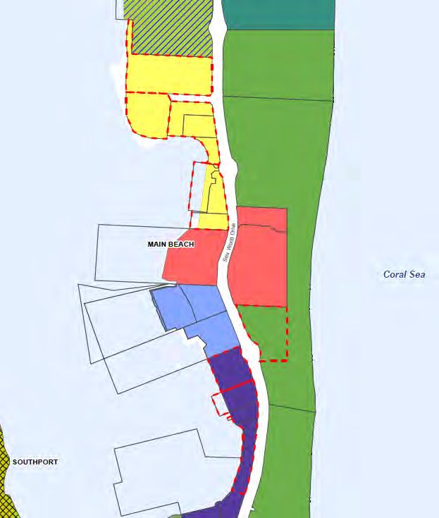
788th Council Meeting 6 May 2020                                                                           1099
        Planning and Environment Committee Meeting 29 April 2020                                          Adopted Report

          Item 1:           Strategic framework
          Summary
          Include appropriate assessment benchmarks for the key development sites.

          Explanation
          The key development sites will be included in two zones in City Plan:
          (1) Major tourism zone (The Spit northern, southern and eastern precincts); and
          (2) Waterfront and marine industry zone (The Spit marine industry precinct).

          City officers note that currently under City Plan’s Strategic framework, the Major tourism zone is a non-
          urban area. Minor changes have been made to the Strategic framework to ensure the new major
          tourism zone precincts are urban areas, whilst maintaining other Major tourism zoned areas throughout
          the City as non-urban, consistent with current policy. It was important for these areas to be urban areas
          in City Plan, given the master plan outcomes for the key development sites are for urban activities. To
          facilitate this change, land included within the Major tourism zone precincts are now identified as part of
          “The Spit tourism area” for the purposes of the Strategic framework. To create consistency across the
          amendment, the remaining land included within the Waterfront and marine industry zone are now
          identified as part of “The Spit marine industry area”.

          Appropriate assessment benchmarks have been included throughout the Strategic framework to give
          effect to the outcomes of the master plan and to provide a line of sight to the zone codes and overlay.

          To reflect the changes to the Strategic framework, the Strategic framework maps 1, 2 and 5 have also
          been updated.

          State interests considered
          Ministerial direction
          The changes comply with Ministerial Direction to the Gold Coast City Council under Section 26 of the
          Planning Act 2016, by including appropriate assessment benchmarks for each key development lot.

          The Spit Master Plan
          The assessment benchmarks have been drafted having regard to the city wide strategies and The Spit
          Master Plan.

          State Planning Policy, July 2017
          No State interests in the State Planning Policy, July 2017 are considered relevant to these changes.
          See Item 2 and 3 for detailed state interest assessment on the assessment benchmarks, changes to the
          strategic framework are considered consequential to the changes in the zone and overlay codes.

          South East Queensland Regional Plan 2017 (ShapingSEQ)
          No State interests in ShapingSEQ are considered relevant to these changes. See Item 2 and 3 for
          detailed state interest assessment on the assessment benchmarks, changes to the strategic framework
          are considered consequential to the changes in the zone and overlay codes.

ii   iSPOT: #75952528 (MS Word) – The Spit Master Plan Implementation (Key Development Sites) amendment          Page 3 of 14
788th Council Meeting 6 May 2020                                                                           1100
        Planning and Environment Committee Meeting 29 April 2020                                          Adopted Report

          Item 2: The Spit Master Plan elements overlay code
          Summary
          Introduce a new The Spit Master Plan elements overlay and overlay code to regulate built form
          and public space/realm elements as identified in The Spit Master Plan.

          Explanation
          The Spit Master Plan elements overlay and overlay code is a necessary requirement to ensure
          appropriate assessment benchmarks relating to built form and public space/realm are regulated to
          deliver the unique characteristics of amendment area, as referenced in The Spit Master Plan. Including
          these provisions in an overlay ensures, to the extent there is any inconsistency with other codes, the
          outcomes of the overlay code prevail.

          City officers note that the public realm elements identified in this overlay are to:

          (a) be delivered in accordance with State Government requirements as set out in the relevant
              Development Agreement;
          (b) remain in either State Government or private ownership; and
          (c) not become trunk infrastructure.

          Consequential changes have been made to give effect to the new overlay and overlay code.

          State interests considered
          Ministerial direction
          The changes comply with Ministerial Direction to the Gold Coast City Council under Section 26 of the
          Planning Act 2016, by including appropriate assessment benchmarks for each key development lot.

          The Spit Master Plan
          The assessment benchmarks have been drafted having regard to the city wide strategies and the big
          picture strategies in the master plan.

          State Planning Policy, July 2017
          State interests relevant to this change include:

          Guiding Principles
          Drafting of the overlay code focuses on the delivery of outcomes and uses positive language to respond
          the outcomes of The Spit Master Plan. Where necessary, prescriptive language has been used to
          ensure the outcomes of The Spit Master Plan are expressed to promote confidence to the community
          and developers about the expected development outcomes for the area.

          Liveable Communities
          The overlay code generally relies upon:
          • city wide design principles that have been endorsed as part of the Our City Our Plan amendment
              package (i.e. Major update 2 and 3 amendment) to the City Plan and the Site context and urban
              design planning scheme policy; and
          • existing development provisions from the other zone codes in the City Plan; and
          • new development provisions endorsed as part of the Our City Our Plan amendment package.

          Specific changes have been made to these principles to ensure the outcomes of the Master Plan are
          generally delivered. As such, the state interest for Liveable Communities is considered to be met.

          South East Queensland Regional Plan 2017 (ShapingSEQ)
          No State interests in ShapingSEQ are considered relevant to these changes.

ii   iSPOT: #75952528 (MS Word) – The Spit Master Plan Implementation (Key Development Sites) amendment          Page 4 of 14
788th Council Meeting 6 May 2020 1101
Planning and Environment Committee Meeting 29 April 2020 Adopted Report
Item 3: Zoning change and zone codes
Summary
Introduce new zone precincts into the Major tourism zone and Waterfront and marine industry
zone.
Explanation
The key development sites will be included in two zones in City Plan:
(1) Major tourism zone (The Spit northern, southern and eastern precincts); and
(2) Waterfront and marine industry zone (The Spit marine industry precinct).
The Spit Master Plan Area (the master plan area) (Figure 1) is comprised of seven precincts. The key
development sites are only located within two of these precincts, being The Village Centre and The
Southern Gateway (Table 1). The intent of The Village Centre is for a vibrant place that provides an
exciting range of retail, entertainment, cultural, accommodation and commercial activities for the local
community and visitors. The intent of the Southern Gateway is to provide an attractive entry to The Spit.
Figure 1: Map showing the master plan area and seven precincts
ii iSPOT: #75952528 (MS Word) – The Spit Master Plan Implementation (Key Development Sites) amendment Page 5 of 14788th Council Meeting 6 May 2020 1102
Planning and Environment Committee Meeting 29 April 2020 Adopted Report
The Ministerial Direction requires the amendment to be made by 30 July 2020. Given this requirement,
when determining the most appropriate zoning designation for the key development sites, City officers
considered it essential that the proposed zoning designation resulted in minimal disruption to the City
Plan (i.e. minimal consequential changes to the Strategic Framework) and the anticipated land uses
generally aligned with the purpose of the zone. The amendment area is currently located within the
Community facilities zone, Open space zone and Waterfront and marine industry zone of the City Plan,
as shown in Figure 2. The suitability of the master plan outcomes for each key development site is
presented in Table 1.
Figure 2: Map showing the amendment area and currently City Plan zoning
Table 1: Table comparing master plan outcomes to suitability of current City Plan zoning
Key development site Master plan Master plan outcome Current Suitability
(Refer Figure 1) precinct zoning
Lot 530 on WD6522 The Village 5.10, 5.12, 5.14, 5.15, Community Not suitable. The purpose of this zone is to
Precinct (Village 5.17 and 5.18 facilities provide for community related activities. Whilst
centre North) the amendment will provide some community
Lot 381 on WD5096, Lot 5.19, 5.20 and 5.21 related activities, the development outcomes
273 on WD3813 and Lot on these sites are for a mixture of business,
12 on SP273760 community, recreation and environmental,
tourism and entertainment activities, service
Lot 13 on USL 33533, 5.22 and 5.24 industry, landing and port services.
Lot 621 on WD6252 and
Lot 359 on WD5111
Lot 503 on WD6249 The Village 5.31 Waterfront Not suitable. The purpose of this zone is to
Precinct (Village and marine provide for uses for which a location adjoining
centre South) industry or near the waterfront or a marine environment
is essential. The development outcomes on
these sites are for a mixture business,
ii iSPOT: #75952528 (MS Word) – The Spit Master Plan Implementation (Key Development Sites) amendment Page 6 of 14788th Council Meeting 6 May 2020 1103
Planning and Environment Committee Meeting 29 April 2020 Adopted Report
community, recreation and environmental,
residential, tourism and entertainment
activities, service industry, landing and port
services.
Lot 504 on WD5735 5.32 Suitable. The purpose of this zone is to
provide for uses for which a location adjoining
or near the waterfront or a marine environment
is essential. The development outcome on this
site is for a maritime regional office which
requires waterfront access.
Part of Lot 318 on The Village 5.28 Open Not suitable. The purpose of this zone is to
WD800475 Precinct (Village Space provide for local, district and regional scale
centre South) parks. The development outcomes on these
sites are for a range of business and tourism
and entertainment activities.
Lot 505 and 506 on The Southern 7.2 and 7.3 Waterfront Suitable. The purpose of this zone is to
WD5735 and Part of Lot Gateway and marine provide for uses for which a location adjoining
400 on SP174972 industry or near the waterfront or a marine environment
is essential. The development outcomes on
these sites are for marine relates activities.
Given the lack of suitable outcomes shown in Table 1, City officers are recommending a change to the
zoning designation of a number of the key development sites to reflect the master plan outcomes.
Analysis
When determining the most appropriate zoning designation for the key development sites, City officers
considered it essential that the proposed zoning designation results in minimal disruption to the City
Plan (i.e. minimal consequential changes to the Strategic Framework) and the anticipated land uses
generally aligned with the purpose of the zone.
Existing Waterfront and marine industry zone
As detailed in Table 1, when reviewing the outcomes of the master plan for key development sites that
are currently in the Waterfront and marine industry zone, the suitability of the current zoning designation
was generally consistent with the outcomes of the master plan identified.
However, during the preliminary state interest review, the Department requested several key
development sites that were proposed to be retained in the Waterfront and marine industry zone to be
included within the same zone as the key development site to the north. The Department requested
these changes to allow for flexibility in the sale and delivery of these sites.
Therefore, it is proposed to:
i. maintain part of Lot 504 on WD5735 within the Waterfront and marine industry zone; and
ii. create a new zone precinct named ‘The Spit marine industry precinct’ in the Waterfront and
marine industry zone; and
iii. rezone Lot 503 on WD6249 and part of Lot 504 on WD5735 to Major Tourism zone.
The creation of a zone precinct for this area would ensure that the unique characteristics of the master
plan could be appropriately reflected in the City Plan. For example, specific built form requirements are
sought in the master plan in these areas that would not be desirable in other Waterfront and marine
industry areas in the City, such as the Gold Coast marine precinct.
The proposed zoning changes to Lot 503 on WD6249 and Lot 504 on WD5735 are illustrated in Figure
3.
ii iSPOT: #75952528 (MS Word) – The Spit Master Plan Implementation (Key Development Sites) amendment Page 7 of 14788th Council Meeting 6 May 2020 1104
Planning and Environment Committee Meeting 29 April 2020 Adopted Report
Zoning designation for the remaining land parcels
As detailed in Table 1, when reviewing the outcomes of the master plan for the remaining key
development sites in The Spit amendment area, the suitability of the current zoning designation was not
consistent with the outcomes of the master plan. Given that all of these remaining key development
sites are located within the Village Centre Precinct, applying a consistent zone for these key
development sites would provide for a cohesive waterfront destination in accordance with the master
plan. This would also help minimise the complexity of the amendment, and consequently, the impact on
City Plan.
City officers undertook a zoning options analysis for the remaining key development sites, evaluating
the existing zones in City Plan to determine the most appropriate zoning designation. City officers
determined the outcomes of the master plan would be best delivered through either the Major tourism
zone or the Mixed use zone. The Centre zone was not considered appropriate given the potential
impact to the city’s centre hierarchy and the fact there are no Performance outcomes or Acceptable
outcomes for this zone.
Upon further analysis, City officers concluded the Major tourism zone was the preferred approach:
• subject to minor changes, a Major tourism zone designation would result in less consequential
changes throughout the City Plan, namely the Strategic Framework; and
• the current table of assessment for both zones indicates the Major tourism zone is more
compatible with the land uses envisaged in the master plan.
Based on these findings, the Department agreed the remaining key development sites should be
included within the Major tourism zone. Upon review the key development sites, there were three
distinctive areas, each with their own unique characteristics. As such, the following new zone precincts
are proposed:
• The Spit northern tourism precinct;
• The Spit southern tourism precinct; and
• The Spit eastern tourism precinct.
The proposed zoning changes for the remaining key development sites are illustrated in Figure 3.
Figure 3: Map showing the current and proposed City Plan zoning
ii iSPOT: #75952528 (MS Word) – The Spit Master Plan Implementation (Key Development Sites) amendment Page 8 of 14788th Council Meeting 6 May 2020 1105
Planning and Environment Committee Meeting 29 April 2020 Adopted Report
State interests considered
Ministerial direction
The changes comply with Ministerial Direction to the Gold Coast City Council under Section 26 of the
Planning Act 2016, by
• including appropriate assessment benchmarks for each key development lot; and
• including each key development lot in a zone (or zones) that is or are compatible with the uses
shown in the master plan for each of the key development lots.
The Spit Master Plan
The assessment benchmarks have been drafted having regard to the city wide strategies and the
outcomes in The Spit Master Plan. The zoning for each site aligns with the outcomes of the master plan,
except for those changes requested specifically from the Department which defers from the master
plan.
State Planning Policy, July 2017
State interests relevant to this change include:
Guiding Principles
Drafting of the zone code focuses on the delivery of outcomes and uses positive language to respond
the outcomes of The Spit Master Plan. Where necessary, prescriptive language has been used to
ensure the outcomes of The Spit Master Plan are expressed to promote confidence to the community
and developers about the expected development outcomes for the area.
Housing supply and diversity and Liveable communities
The proposed zoning changes are located in existing urban areas under the planning scheme
(Community Facilities and Waterfront and marine industry), excluding a small portion of land on the
eastern side of Seaworld Drive, which is currently open space. It is noted that this area of open space is
directly adjacent to Medium density residential zone to the north and contains existing buildings and
structures.
The proposed amendment is located within the City’s priority infrastructure area and is surrounded by a
mixture of resorts, theme parks and community infrastructure and is currently serviced.
It is important to note that further planning scheme amendments will be considered which may facilitate
appropriate zoning outside of the amendment area. These future amendments will provide a mixture of
land uses to contribute to destination that exemplifies a balance between tourism, recreation, leisure
experiences and the environment, as envisaged by the master plan.
Development and construction
The proposed amendment will be located on State Land which will be subject to future lease
arrangements. The proposed zoning seeks to facilitate outcomes of the Spit Master Plan. Through
consultation, this area was identified as an appropriate area for future development opportunities, with
other State Land areas to be utilised for recreation and conservation purposes.
Tourism
A key strategy of the Spit Master Plan is to build and strengthen on the existing capabilities of the Spit
as being an area known for tourism and recreational opportunities. The proposed Major Tourism Zone
will capitalise upon the existing opportunities of The Spit as being an iconic tourist destination by
encouraging a mixed use waterfront tourism destination.
Biodiversity
Based upon the online SPP mapping, no MLES or MSES is present in the amendment area, excluding a
small portion of land on the eastern side of Seaworld Drive which is currently Open Space. In the
context of the Spit Master Plan, this area is very minor. Future development will require assessment
against the biodiversity overlay code under the planning scheme to mitigate any potential impacts,
where triggered by the overlay. Based upon the online SARA mapping, Koala habitat is not present on
the site.
ii iSPOT: #75952528 (MS Word) – The Spit Master Plan Implementation (Key Development Sites) amendment Page 9 of 14788th Council Meeting 6 May 2020 1106
Planning and Environment Committee Meeting 29 April 2020 Adopted Report
Cultural heritage
It is understood that the State Government has undertaken consultation with traditional owners
throughout the master planning process. Any reflection of these interests would have been reflected in
the master plan and reflected through the State Governments ongoing consultation with these traditional
owners. It is noted that the amendment area contains a local heritage place, being the Humphreys Boat
Shed and Slipway Remnants, any future development will require consideration against the Heritage
overlay code to conserve its cultural heritage significance.
Coastal environment and water quality
The proposed zoning changes are located in existing urban areas under the planning scheme
(Community facilities and Waterfront and marine industry), excluding a small portion of land on the
eastern side of Seaworld Drive which is currently Open Space. It is noted that this area of Open Space
is directly adjacent to Medium density residential zone to the north and contains existing buildings and
structures. The proposed extension of this urban zoning is logical to facilitate the outcomes of the
master plan.
Natural hazards, risk and resilience
The subject site is partially located within the flood hazard, medium storm tide inundation area and
erosion prone area. The majority of the Spit area is located within the erosion prone area and medium
storm tide inundation areas and has been subject to extensive development to the north and south of
the amendment area. As the proposed zoning change is as a result of a Ministerial Direction, a fit for
purpose risk assessment is not deemed necessary given the changes are consistent with the Ministerial
Direction.
A large portion of the subject site is located outside of the erosion prone area and flood area, with future
development requiring setbacks from the waters edge. Existing natural landforms will assist in
minimising impacts of coastal erosion through outcome 5.13 of the Spit Masterplan, which seeks to
maintain vegetation adjacent to the Broadwater. Each lot has the ability to design future development
with flood free vehicular access to Sea World Drive.
Existing adjacent developed areas have been required to construct a revetment wall to minimise the risk
of erosion and storm tide inundation. It is likely that a revetment wall will be required in areas where
vegetation buffers are not present.
It is noted that the development outcomes of the subject site will be limited to three storeys or 15
metres, which is consistent with surrounding developments. Impacts from the natural hazards (flood and
coastal erosion), will be mitigated under the planning scheme by elevating any accepted development
land uses to accepted, subject to requirements which will require assessment against the coastal
erosion hazard overlay code and the flood overlay code.
South East Queensland Regional Plan 2017 (ShapingSEQ)
State interests relevant to this change include:
Grow – Efficient land use
The amendment area is located within the Urban Footprint of ShapingSEQ.
Prosper – REC’s and Tourism
The site is located with close proximity to the Southport-Broadbeach REC. This REC is a corridor of
activity, which includes health and knowledge, cultural and creative, commercial and corporate services,
tourism and higher order consumer functions. Although the site is not located within the REC, there is
significant opportunity for these changes to contribute the tourism and higher order consumer functions
of the REC given the areas unique characteristics.
A key strategy of the master plan is to build and strengthen on the existing capabilities of the Spit as
being an area known for tourism and recreational opportunities. This area has been specifically
identified within the master plan, as an area for residential, commercial and retail development.
Sustain - Aboriginal and Torres Strait Islander people and Regional landscapes
ii iSPOT: #75952528 (MS Word) – The Spit Master Plan Implementation (Key Development Sites) amendment Page 10 of 14788th Council Meeting 6 May 2020 1107
Planning and Environment Committee Meeting 29 April 2020 Adopted Report
It is understood that the State Government has undertaken consultation with traditional owners
throughout the master planning process. Any reflection of these interests would have been reflected in
the master plan and reflected through the State Governments ongoing consultation with these traditional
owners. It is noted that the amendment area contains a local heritage place, being the Humphreys Boat
Shed and Slipway Remnants, any future development will require consideration against the Heritage
overlay code to conserve its cultural heritage significance.
The site is located within a regional greenspace network. The proposed zoning seeks to facilitate
outcomes of the Spit Master Plan. Through consultation, this area was identified as an appropriate area
for future development opportunities, with other State Land area to be for recreation and conservation
purposes.
ii iSPOT: #75952528 (MS Word) – The Spit Master Plan Implementation (Key Development Sites) amendment Page 11 of 14788th Council Meeting 6 May 2020 1108
Planning and Environment Committee Meeting 29 April 2020 Adopted Report
Item 4: Tables of assessment
Summary
Introduce tables of assessment to regulate levels of assessment.
Explanation
The key development sites will be included in two zones in City Plan:
(1) Major tourism zone (The Spit northern, southern and eastern precincts); and
(2) Waterfront and marine industry zone (The Spit marine industry precinct).
Given the scope of the Ministerial Direction, the key development sites are only located across two
precincts of the master plan, being The Village Centre and The Southern Gateway. The master plan
prescribes land use outcomes for the key development sites.
City officers, together with the Department, have aligned each land use contemplated by the master
plan with a City Plan land use definition. The result of this alignment exercise is presented in Table 2.
Table 2: Proposed code assessable land uses for each zone precinct
Proposed zone Master plan outcome Proposed code assessable land uses
and zone precinct
Major tourism zone 5.12 – A bar and function centre is located close to the water Food and drink outlet
– The Spit northern creating an entertainment venue and meeting place. Office
tourism precinct – 5.14 – A shop front visitor centre is located in a central Shop
Site N1 position, providing information about nearby activities, Health Care Services
accommodation and ways of getting around The Spit, and Market
facilities for booking tourist activities. Community use
5.15 – A building at the intersection of Seaworld Drive and Educational establishment
the new street into the precinct provides a mix of uses, Service industry
including food and beverage outlets on the ground floor level, Environment facility
offices and short term accommodation on upper levels. Park
Major tourism zone 5.17 – A cultural centre is located in a complex adjacent to Landing
– The Spit northern The Broadwater and is a place that signifies and celebrates Port services
tourism precinct – Aboriginal heritage and the association of the Aboriginal Telecommunications facility, subject to
Site N2 people with The Broadwater and surrounds. The centre requirements
enables visitors to learn about and experience the association Bar
of the Aboriginal people with The Spit and its broader setting. Function facility
5.18 – An open space adjacent to the cultural centre enables Hotel
the staging of events such as traditional ceremonies and Short-term accommodation
dance performances. Nature-based tourism
Theatre
Major tourism zone 5.19 – A market and series of smaller retail pavilions provide
– The Spit northern an outlet for fresh seafood and other produce and low key
tourism precinct – dining opportunities.
Site N3 5.20 – A complex of buildings and the associated public
spaces provide opportunities to celebrate and appreciate the
rich and dynamic maritime history of the Gold Coast,
including the story of the formation of The Spit, significant
maritime events such as extreme weather and ship wrecks,
and the legacy of fishing, boating and surfing on the Gold
Coast.
5.21 – The ground floor of the building complex provides
space for maritime remembrance and memorabilia and
retailing and dining opportunities. The upper levels of
the complex provide short term accommodation for visitors to
The Spit.
5.23 – Carters Basin continues to accommodate the local
fishing fleet. A new marina opportunity includes facilities for
superyachts and charter boats and a potential ferry stop that
ii iSPOT: #75952528 (MS Word) – The Spit Master Plan Implementation (Key Development Sites) amendment Page 12 of 14788th Council Meeting 6 May 2020 1109
Planning and Environment Committee Meeting 29 April 2020 Adopted Report
Proposed zone Master plan outcome Proposed code assessable land uses
and zone precinct
has the capacity to provide alternative transport access to the
Village Centre.
Major tourism zone 5.22 – The facilities associated with the fishing fleet are
– The Spit northern reorganised and renewed, enabling the daily catch to be sold
tourism precinct – direct to the public in a convenient and ordered manner.
Site N4 Access along the waterfront past the moored fleet is widened
and improved to enable the safe passage of pedestrians and
cyclists through this area of occasionally busy maritime
activity.
Logistics areas to support the ongoing operation of the fishing
fleet are centrally located and designed so that impacts on
pedestrian movement, views to The Broadwater and the
amenity of nearby accommodation are minimised. Vehicle
access and public parking is integrated across this site and
the site to the south to enable safe and convenient access
to this revitalised part of The Spit.
5.24 – The area directly north of Palazzo Versace is
connected with the adjacent fishing fleet to create a mixed
use maritime sub-precinct focused on fresh seafood supply
with associated retail shops, restaurants and cafes. Informal
outdoor eating areas with views to The Broadwater are
provided near the water's edge. Public access is provided
from Seaworld
Drive through the site to The Broadwater pathway.
The southern edge of the site is landscaped to
provide shade to the pedestrian pathway and soften the
interface between commercial uses and nearby
accommodation.
Major tourism zone 5.30 – A plaza with a landscaped arbour provides a strong Food and drink outlet
– The Spit southern link between The Broadwater and the ocean. Ground floor Health care services
tourism precinct shopping, dining and foyers activate the plaza, creating a Office
promenade that enlivens the southern part of the Village Sales office
Centre. A ferry terminal located at The Broadwater end of the Shop
promenade enhances access to The Spit. Market
5.31 – A mixed use retail, commercial, residential and short Service station – if for the sale of fuel to
term accommodation development occupies the site to the on-water marine craft
south of the plaza, providing an active presence to the plaza’s Community use
edge, The Broadwater and Seaworld Drive. A new marina Educational establishment
associated with the development provides for mooring of Emergency services
boats and accommodates a superyacht berthing facility. The Park
jetty associated with the marina provides public access for Environment facility
pedestrians out over the water. Indoor sport and recreation
5.32 – The Queensland Government maritime regional office Multiple dwelling
is located in a new facility in the Village Centre South. The Retirement facility
facility provides for the operational requirements of the Rooming accommodation
maritime functions, such as the GCWA, Landing Port services
Maritime Safety Queensland, Queensland Water Telecommunications facility, subject to
Police and Queensland Boating and Fishing Patrol, enabling requirements
direct access for vessels to The Broadwater. Bar
7.2 – A secure space for maritime and community facilities is Function facility
located in the northern portion of the precinct. Buildings Short-term accommodation
address the street, naval memorial and The Broadwater. Club
Hotel
Major tourism zone 5.28 – A low scale resort style complex, south of the Food and drink outlet
– The Spit eastern Sheraton Grand Mirage Resort, addresses and enlivens both Office
tourism precinct the plaza and beachfront, and provides a distinctive frontage Shop
to Seaworld Drive. Health care services
Park
ii iSPOT: #75952528 (MS Word) – The Spit Master Plan Implementation (Key Development Sites) amendment Page 13 of 14788th Council Meeting 6 May 2020 1110
Planning and Environment Committee Meeting 29 April 2020 Adopted Report
Proposed zone Master plan outcome Proposed code assessable land uses
and zone precinct
Telecommunications facility, subject to
requirements
Bar
Function facility
Short-term accommodation
Indoor sport and recreation
Hotel
Waterfront and 7.3 – A boat storage facility is located along the edge of The Marine industry
marine industry Broadwater to the north of the yacht club building and does Research and technology industry
zone – The Spit not exceed 15 metres in height. The significance of the Service industry
marine industry existing heritage place is accommodated in the design of the Park
precinct proposed facility and the heritage values are signified on the Landing
site. Port services
Telecommunications facility, subject to
requirements
City officers have considered various ways in which the tables of assessment should operate, having
regard to the proposed structure of the required updates to reflect the intent of the master plan in City
Plan.
The various options considered by City officers included:
• Option 1: per key development sites, as identified in the Ministerial Direction.
• Option 2: the extent of each zone precinct; or
City officers determined applying a table of assessment by:
• per key development sites (Option 1) is not appropriate as this level of prescription may result
in future unintended consequences should lot boundaries change and does not offer any level
of flexibility for the establishment of alternative land uses that may be considered appropriate /
consistent with the master plan.
• the extent of each zone precinct (Option 2) is the most appropriate option because the
outcomes for the master plan for each precinct are generally compatible and will allow an
appropriate degree of flexibility for the establishment of land uses across each precinct;
Therefore it is recommended the table of assessment for the amendment is applied per precinct within
each zone and the land uses identified in Table 2 are shown to be code assessable. Other essential
land uses are recommended to be accepted or accepted subject to requirement, consistent with current
City Plan policy.
State interests considered
Ministerial direction
Land uses envisaged by the master plan are either code or accepted development. It is noted that the
Ministerial direction only applies to land within the lots listed in table 1 that is located above the highest
astronomical tide.
The Spit Master Plan
Council and departmental officers have aligned each land use applicable to the amendment area with a
city plan land use definition.
State Planning Policy, July 2017
No State interests in State Planning Policy, July 2017 are considered relevant to these changes.
South East Queensland Regional Plan 2017 (ShapingSEQ)
No State interests in ShapingSEQ are considered relevant to these changes.
ii iSPOT: #75952528 (MS Word) – The Spit Master Plan Implementation (Key Development Sites) amendment Page 14 of 14You can also read