Armstrong Creek West Precinct Structure Plan Flooding investigations - October 2011 Stage 2
←
→
Page content transcription
If your browser does not render page correctly, please read the page content below
Armstrong Creek
                    West Precinct Structure Plan
                         Flooding investigations

                                      October 2011
                                           Stage 2

ISO 9001 QEC22878
    SAI Global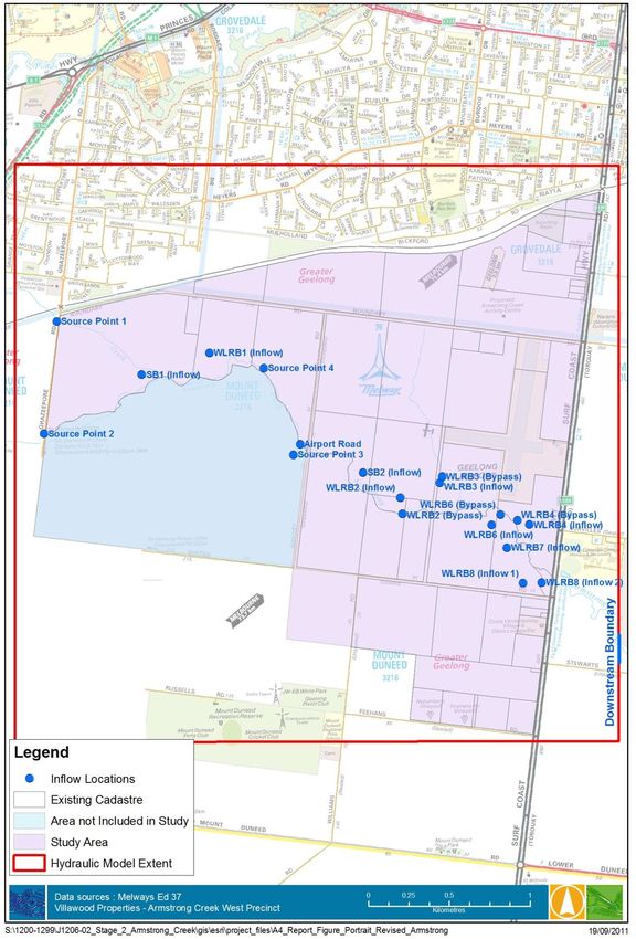
Villawood – Armstrong Creek West Precinct
Flooding investigations

DOCUMENT STATUS
Version                   Doc type                  Reviewed by                 Approved by                 Date issued
v01                       Preliminary Draft         CMB                         CMB                         25/08/2011
v02                       Preliminary Draft         LJC                         LJC                         29/08/2011
v03                       Preliminary Draft         LJC                         LJC                         30/08/2011
v04                       Draft                     LJC                         CMB                         10/10/2011
v05                       Draft                     LJC                         LJC                         11/10/2011
v06                       Draft                     LJC                         LJC                         14/10/2011
v07                       Draft Final               LJC                         LJC                         24/10/2011

PROJECT DETAILS
Project Name                                         Armstrong Creek West PSP Stage 2
Client                                               Villawood Properties
Client Project Manager                               Tao Bourton
Water Technology Project Manager                     Luke Cunningham
Report authors                                       KLR, LJC
Job number                                           1206-02
Report number                                        R01
Document Name                                        J1206-
                                                     02_R01_v07_Armstrong_Creek_October_2011.docx

Copyright

Water Technology Pty Ltd has produced this document in accordance with instructions from Villawood Properties for their
use only. The concepts and information contained in this document are the copyright of Water Technology. Use or copying
of this document in whole or in part without written permission of Water Technology Pty Ltd constitutes an infringement
of copyright.

This report has been prepared on behalf of and for the exclusive use of Villawood Properties, and is subject to and issued in
connection with the provisions of the agreement between Water Technology Pty Ltd and its Client. Water Technology Pty
Ltd accepts no liability or responsibility whatsoever for or in respect of any use of or reliance upon this report by any third
party.

                                                                                                  15 Business Park Drive
                                                                                                  Notting Hill VIC 3168
                                                                                       Telephone            (03) 9558 9366
                                                                                       Fax                  (03) 9558 9365
                                                                                       ABN No.             60 093 377 283
                                                                                       ACN No.                 093 377 283

J1206-02 / R01 v07 Stage 24 October 2011                                                                                     ii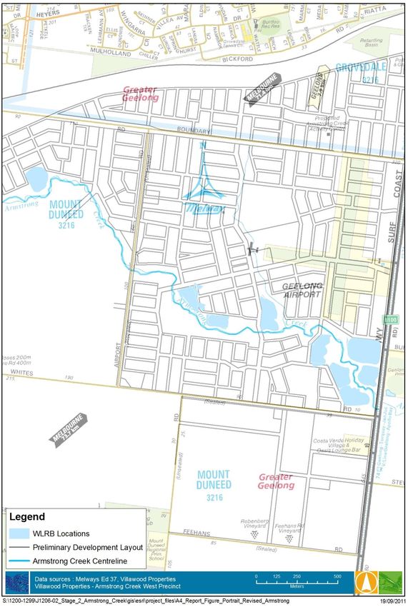
Villawood – Armstrong Creek West Precinct
Flooding investigations

TABLE OF CONTENTS
1.       Introduction .................................................................................................................. 1
1.1      Previous Studies ...................................................................................................................... 1
1.2      Scope ....................................................................................................................................... 1
1.3      Study Area ............................................................................................................................... 2
2.       Existing conditions flood behaviour ................................................................................ 4
2.1      Overview.................................................................................................................................. 4
2.2      Hydrologic Modelling .............................................................................................................. 4
2.3      Hydraulic Modelling................................................................................................................. 5
3.       Developed conditions flood behaviour ........................................................................... 7
3.1      Overview.................................................................................................................................. 7
3.2      Flood Mitigation Measures ..................................................................................................... 7
         3.2.1    Wetlands and Retarding Basins ............................................................................... 7
         3.2.2    Other Flood Mitigation Treatments ......................................................................... 9
3.3      Hydrologic Modelling ............................................................................................................ 10
         3.3.1    Developed Conditions RORB Model....................................................................... 10
         3.3.2    Model Calibration................................................................................................... 10
         3.3.3    Modelling Parameters ............................................................................................ 10
3.4      Hydraulic Modelling............................................................................................................... 14
4.       Conclusions and Assumptions ...................................................................................... 22
5.       References .................................................................................................................. 23
Appendix A        Flood Extents for Remaining ARIs ....................................................................... 24

LIST OF FIGURES
Figure 1-1        Study area (note: Western Industrial Precinct shaded blue is not part of this report) 3
Figure 2-1        100 year ARI 12 hour duration hydrographs (m3/s) for input to hydraulic model –
                  Existing Conditions ........................................................................................................ 4
Figure 2-2        100 year ARI, 12 hour duration hydrographs (m3/s) at Airport Road and Surf Coast
                  Highway ......................................................................................................................... 5
Figure 2-3        Design flood levels and extents – 100 year existing catchment conditions ................. 6
Figure 3-1        Locations of proposed Wetland/Retarding Basins (Design by Neil M Craigie) ............. 9
Figure 3-2        100 year ARI 12 hour duration hydrographs (m3/s) for input to hydraulic model –
                  Developed Conditions ................................................................................................. 12
Figure 3-3        RORB Hydrograph Inflow Locations to the Hydraulic Model ...................................... 13
Figure 3-4        Model Topographic Grid – Developed Conditions (please note: Development Areas
                  Filled in Hydraulic Model) ........................................................................................... 15
Figure 3-5        Design flood levels and extents – 100 year developed catchment conditions ........... 17
Figure 3-6        100 year ARI 12 hour duration hydrographs (m3/s) at Airport Road and Surf Coast
                  Highway under developed conditions ........................................................................ 19

J1206-02 / R01 v07 Stage 24 October 2011                                                                                                             iii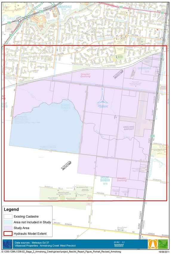
Villawood – Armstrong Creek West Precinct
Flooding investigations

Figure 3-7    Water Surface Elevations (WSE) at the culvert constriction showing a head drop of
              approximately 500mm ................................................................................................ 21

LIST OF TABLES
Table 3-1     RORB Model Calibration Details.................................................................................. 10
Table 3-2     IFD Parameters ............................................................................................................ 10
Table 3-3     Runoff Coefficient Values Used ................................................................................... 11
Table 3-4     Wetland/Retarding Basin Bypass Flow Rates.............................................................. 11
Table 3-5     Existing and Developed Peak Flows at Airport Road and Surf Coast Highway ........... 20

J1206-02 / R01 v07 Stage 24 October 2011                                                                                                 iv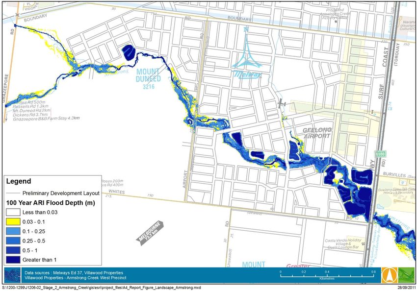
Villawood – Armstrong Creek West Precinct
Flooding investigations
1. INTRODUCTION
This report documents the investigation of flooding behaviour undertaken as part of the preparation
of the Armstrong Creek Western Precinct Structure Plan. The investigation includes wetland and
basin designs along with creek protection works completed by Neil M Craigie as well as flood
mapping and mitigation investigations completed by Water Technology. These investigations were
commissioned by Villawood Properties on behalf of the West Consortium.
Neil M Craigie and Water Technology Pty Ltd were appointed as a team to complete the hydrologic,
hydraulic and water quality modelling tasks for the Armstrong Creek West Precinct (ACWP). This
report details the RORB and MIKE Flood modelling (hydrologic and hydraulic modelling) of the
catchment from Ghazepore Road to immediately downstream of the Surf Coast Highway. The
investigations consider the flood behaviour under the pre and post development catchment
conditions, and outlined flood management treatments. The flood management treatments were
aimed to mitigate any adverse impacts on flood behaviour due to the development of the ACWP.
Assumptions made in this report regarding subcatchment drainage and wetland location and sizing
are based on the work completed by Neil M Craigie in a separate report titled Armstrong Creek West
Precinct (ACWP) Stormwater Management Strategy, Version 1 - Draft, September 2011 (Neil M
Craigie, 2011). The report completed by Neil M Craigie focuses on the subcatchment urban drainage
systems, sediment basin and wetland sizing and levelling and includes the results of MUSIC
modelling to confirm compliance with best practice conditions and requirements.
The underlying principle of the assessment of flood management treatments was to eliminate any
adverse flooding impacts due to the development. Particular consideration was given to maintaining
pre-development (existing) peak flows into at the Surf Coast Highway and Airport Road.
1.1 Previous Studies
The Corangamite Catchment Management Authority (CCMA) undertook an investigation of the flood
behaviour under the existing (undeveloped) and developed catchment conditions (CCMA, 2009). The
CCMA investigations established the base case for the comparison of the flood behaviour under the
developed conditions.
The following investigations have previously been completed by Water Technology and Neil M
Craigie, as documented in the Stage 1 Flooding Investigations report (November 2010):
Investigation of pre-development (existing) catchment conditions and flood behaviour; and,
Investigation of developed catchment conditions and flood behaviour, based on the proposed
land uses and modifications to existing drainage associated with the West Armstrong Creek
Precinct.
The flooding investigations were undertaken using a RORB Runoff Routing model to estimate design
flood hydrographs into Armstrong Creek and a MIKE FLOOD hydraulic model to investigate flood
levels, flows and extents throughout the study area.
1.2 Scope
The purpose of this study is to assess flood behaviour under developed catchment conditions with
flood mitigation measures in place. Arrays of retarding basins/wetlands have been designed for the
precinct by Neil M Craigie for mitigation purposes. Enhanced floodplain storage through the use of
culvert restrictions and barriers have also been introduced to the model to assist in mitigating the
developed conditions flows to existing conditions. This report describes the hydraulic effect of this
system and covers the following scope:
J1206-02 / R01 v07 Stage 24 October 2011 1
Villawood – Armstrong Creek West Precinct
Flooding investigations
Hydrologic modelling of the developed catchment;
Description of flood mitigation measures employed;
Hydraulic modelling of developed catchment with flood mitigation; and,
Assessment of mitigated developed conditions flood behaviour against pre-development
conditions
1.3 Study Area
The study area is defined as the Armstrong Creek catchment to the west of the Surf Coast Highway,
earmarked for residential development. The Western Industrial Precinct (to the west of Airport
Road, and to the south of Armstrong Creek) is being considered as part of a separate flooding
investigation. For the purposes of this investigation, it was assumed that any flood management
treatments for the Western Industrial Precinct would be located within that precinct, and would
mitigate any adverse flood impacts arising from the industrial precinct. The flood behaviour (runoff)
for the western industrial precinct was taken as for the existing (pre-development) conditions.
Figure 1-1 displays the study area.
J1206-02 / R01 v07 Stage 24 October 2011 2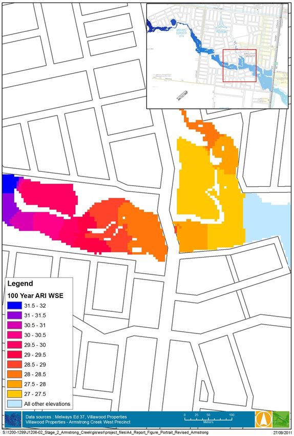
Villawood – Armstrong Creek West Precinct
Flooding investigations

                             Airport
                              Road

                                                                  Surf Coast
                                                                  Highway

Figure 1-1    Study area (note: Western Industrial Precinct shaded blue is not part of this report)

J1206-02 / R01 v07 Stage 24 October 2011                                                         3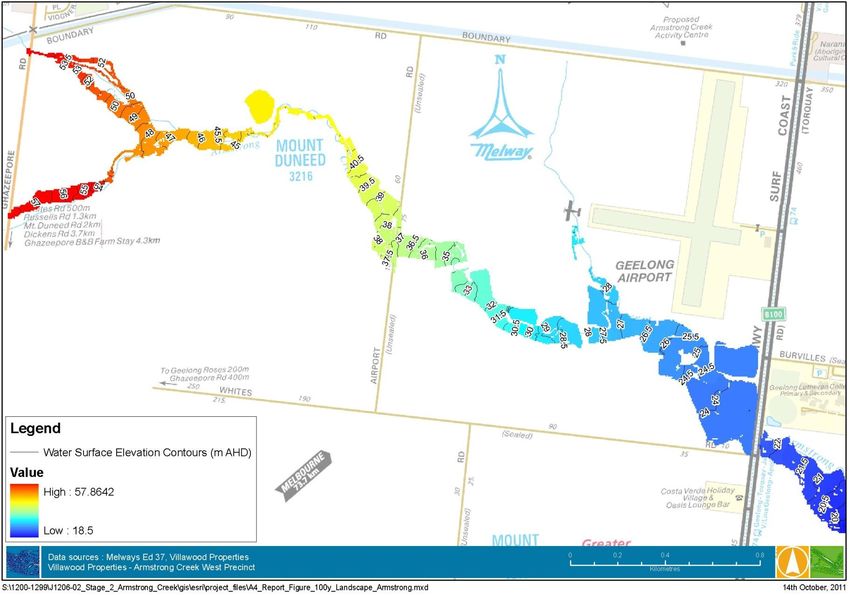
Villawood – Armstrong Creek West Precinct
Flooding investigations

2. EXISTING CONDITIONS FLOOD BEHAVIOUR
2.1                                 Overview
An assessment of the existing conditions flood behaviour was undertaken in the Stage 1 Flooding
Investigations report (Water Technology, 2010). The results of the assessment are summarised in
the following sections. For further information regarding run parameters, calibration, etc., please
refer to the Stage 1 Investigation report (Water Technology, 2010).

2.2                                 Hydrologic Modelling
Design flood hydrographs were determined using an existing conditions RORB model adapted from
the CCMA RORB model (2009) for input to the existing conditions hydraulic (MIKE FLOOD) model.
The 12 hour duration storm was found to be the critical duration for the 100 year ARI flow at Airport
Road and Surf Coast Highway. The hydrographs for hydraulic model inflows derived from the RORB
model are shown in Figure 2-1 below.

                   7.00
                   6.50                                                                                                                                              Inflow K2
                   6.00                                                                                                                                              Inflow F2
                   5.50
                                                                                                                                                                     Inflow Valley Rail
                   5.00
                                                                                                                                                                     Inflow L
                   4.50
   Inflow (m3/s)

                                                                                                                                                                     Inflow T
                   4.00
                   3.50                                                                                                                                              Inflow W
                   3.00                                                                                                                                              Inflow M
                   2.50                                                                                                                                              Inflow N
                   2.00                                                                                                                                              Inflow V
                   1.50                                                                                                                                              Inflow X
                   1.00
                                                                                                                                                                     Inflow Ghaz Sth
                   0.50
                                                                                                                                                                     Inflow Ghaz Nth
                   0.00
                                                                                                                                                                     Inflow U
                          12:00
                                  14:00
                                          16:00
                                                  18:00
                                                          20:00
                                                                  22:00
                                                                          0:00
                                                                                 2:00
                                                                                        4:00
                                                                                               6:00
                                                                                                      8:00
                                                                                                             10:00
                                                                                                                     12:00
                                                                                                                             14:00
                                                                                                                                     16:00
                                                                                                                                             18:00
                                                                                                                                                     20:00
                                                                                                                                                             22:00

                                                                                                                                                                     Inflow Mag
                                                                                   Time (hours)

Figure 2-1                          100 year ARI 12 hour duration hydrographs (m3/s) for input to hydraulic model –
                                    Existing Conditions

J1206-02 / R01 v07 Stage 24 October 2011                                                                                                                                                  4
Villawood – Armstrong Creek West Precinct
Flooding investigations
2.3 Hydraulic Modelling
An existing conditions MIKE FLOOD 1D/2D hydraulic model was produced for the Stage 1 Flooding
Investigations Report (Water Technology, 2010). The hydraulic model was employed for this report
to establish the ‘base case’ scenario. Since the Stage 1 Investigations, the road crest levels of the Surf
Coast Highway were surveyed along with the culvert array and amendments were made to the
model to account for this. The existing conditions RORB modelling from the Stage 1 Investigations
were again adopted and input to the hydraulic model.
Figure 2-3 displays the flood behaviour for the 100 year flood events under the existing conditions,
for the residential development areas to the north of Armstrong Creek, and to the south between
Airport Road and the Surf Coast Highway.
Deeper flood waters (greater than 0.5 m) were generally confined to the immediate corridor along
Armstrong Creek, particularly upstream (west) of Surf Coast Highway. Shallow flow (less than 0.2 m
shaded yellow and pale blue) occurred across the Surf Coast Highway in the 100 year event. Away
from the creek corridor, the flows across the floodplain were generally less than 0.2 m in depth.
The general flood extent is consistent with the flood mapping in Water Technology (2007). Some
differences have arisen due to the use of different topographic data, and design flood hydrographs.
Further, minor overland flow paths were not mapped in this investigation.
The flow hydrographs at Airport Road and Surf Coast Highway were extracted from the model and
are shown in Figure 2-2 below. The peak flows of 15.8 m3/s at Airport Road and 24.0 m3/s at Surf
Coast Highway were derived from the MIKE FLOOD model and will be adopted as the existing
conditions flows at these locations. Under developed conditions the flows at these locations will
need to be comparable to existing conditions to ensure no adverse impacts on neighbouring
properties.
30
Airport Rd Existing
Surf Coast Hwy Existing Surf Coast Hwy – 24.0 m3/s peak
25
20
Flow (m3/s)
Airport Road – 15.8 m3/s peak
15
10
5
0
0 2 4 6 8 10 12 14
Hours
Figure 2-2 100 year ARI, 12 hour duration hydrographs (m3/s) at Airport Road and Surf Coast
Highway
J1206-02 / R01 v07 Stage 24 October 2011 5Villawood – Armstrong Creek West Precinct Flooding investigations Figure 2-3 Design flood depths and extents – 100 year existing catchment conditions J1206-02 / R01 v07 Stage 24 October 2011 6
Villawood – Armstrong Creek West Precinct
Flooding investigations – Stage 2

3.             DEVELOPED CONDITIONS FLOOD BEHAVIOUR
3.1            Overview
Proposed land use within the West Armstrong Creek Precinct will consist of residential and
commercial development, and public open space. The proposed development will increase the
impervious surface, and realign and modify current drainage paths within the catchments.
The underlying principle of the assessment of flood management treatments was to eliminate any
adverse high flow flooding impacts due to the development. Particular consideration was given to
maintaining pre-development peak flows at Airport Road and the Surf Coast Highway. Geomorphic
impacts of low flow high frequency increases are considered in the water quality strategy (Craige,
2011).
For this precinct, the principal flood management treatment proposed is a number of
wetland/retarding basins. A centralised flood management approach has been adopted with
proposed wetlands/retarding basins located adjacent to Armstrong Creek. These locations enable
the enhancement of the values and the amenity of Armstrong Creek, provides for efficient use of
drainage infrastructure, and minimises ongoing maintenance requirements. The conceptual
wetland/retarding basin arrangements are consistent with the Urban Growth Plan.
The hydrologic and hydraulic models discussed in the Stage 1 Flooding Investigations report (Water
Technology, 2010), were revised to reflect these changes due to the proposed development.
Further, the flood management treatments have a dual purpose to mitigate the impacts on
stormwater runoff quality, as well as flood behaviour. All indicative wetlands are sited to minimise
vegetation disturbance and to make best use of the terrain as to minimise earthworks. Modification
to the position of these wetlands is considered undesirable. Further details of stormwater quality
modelling are provided in the report provided by Neil M Craigie (2011).

3.2            Flood Mitigation Measures
3.2.1          Wetlands and Retarding Basins
As discussed in the Stage 1 Flooding Investigations report (Water Technology 2010), the proposed
development (without mitigation), leads to a considerable increase in the peak flow and flood
volume. To alleviate these increases, Neil M Craigie prepared an initial conceptual wetland/retarding
basin arrangement (see Figure 3-1 for locations). The aim of the wetlands/retarding basins is to
provide temporary storage of runoff, and thus limit peak flow rates into Armstrong Creek. SB1
(Sedimentation Basin 1) shown in previous reports has been removed from the modelling. It is
understood by Water Technology that SB1 is for the future industrial precinct and does not offer
flood protection or water quality treatment for the residential precinct.
This conceptual design located retarding basins/wetlands at the significant sub-catchment outlets to
Armstrong Creek. The layout and design of the wetland/basins was an iterative process working to
balance the requirements of native vegetation conservation, existing road alignments and proposed
development layouts, etc. This has resulted in various re-designs of the wetlands throughout the
process with the goal maintaining the water quality and quantity objectives while minimising
disturbance. The potential to distribute the wetlands and basins was limited due to the Airport Road
and Surf Coast Highway creek crossings as well as the proposed development road crossings of the
creek.
The wetlands/retarding basins will be formed using existing depressions, with excavation and the
construction of minimal embankments where required. As noted, this location enables the

J1206-02 / R01 v07 Stage 24 October 2011                                                             7
Villawood – Armstrong Creek West Precinct
Flooding investigations – Stage 2

enhancement of the values and the amenity of Armstrong Creek, provides for efficient use of
drainage infrastructure, and minimises ongoing maintenance requirements.

    WLRB1
                                                             WLRB3
                                             SB2

                                                   WLRB2

                                                                                WLRB4

                                 Road Crossing:          WLRB6
                                 New Culverts

                                                               WLRB7

                                                                    WLRB8
                                                                                    WLRB5

   WLRB = Wetland/Retarding Basin
   SB = Sedimentation Basin

J1206-02 / R01 v07 Stage 24 October 2011                                                      8
Villawood – Armstrong Creek West Precinct Flooding investigations – Stage 2 Figure 3-1 Locations of proposed Wetland/Retarding Basins (Design by Neil M Craigie) Generally, shallow overland flowpaths to the north and south of Armstrong Creek will be piped as part of the drainage infrastructure. In particular, the tributary flowing from the corner of Ghazeepore and Boundary Roads is likely to be piped as part of the VicRoads’ proposed 4C alignment works. The tributary currently through the Airport will remain as open waterway to the south of the current runway. For this assessment, it was assumed that VicRoads would provide treatments to offset any change in runoff behaviour arising from the 4C alignment. Consultation with VicRoads will be undertaken as part of future investigations. As well as providing flood storage, the wetlands will provide storm water treatment. Details of the stormwater quality aspects are shown in the report provided by Neil M Craigie. The CCMA (2009) calculated a total required detention storage of 85,620 m3 for the entire western precinct. This included a detention storage of 11,700 m3 for the western industrial precinct. Removing this allowance for the western industrial precinct leaves a detention storage for the residential area of 73,920 m3. Table 1 in the report provided by Neil M Craigie summarises the catchments and design parameters for each of the treatment assets along the Armstrong Creek corridor. The total flood storage available as shown in Table 1 (Neil M Craigie, 2011) is 80,800 m3. The conceptual wetland arrangement therefore provides flood storage in line with the CCMA estimate. Further details of the wetland/retarding basin designs and hydraulic controls are shown in the report provided by Neil M Craigie. It is noted that the City of Greater Geelong does not support the use of rainwater tanks for flood management purposes. Villawood will promote the use of rainwater tanks on site throughout the development, with any available storage in the tanks potentially adding to the available flood storage within the catchment in developed conditions. Storage from rainwater tanks has not been included in our calculations or modelling. As noted, this detention storage does not include an allowance for the western industrial precinct. It was assumed that the sufficient detention storage would be provided within the industrial precinct to mitigate runoff from the proposed industrial precinct. 3.2.2 Other Flood Mitigation Treatments To achieve the required flow values at both Airport Road and Surf Coast Highway, further mitigation treatments were required. The additional mitigation treatments also have the added benefit of protecting the Surf Coast Highway from overland flow in a 100 year ARI event which is flooded to depths of greater than 300 mm in existing conditions. Culvert constrictions and a low wall along the Surf Coast Highway were both incorporated to increase the available flood storage within the ACWP. The two road crossings shown in Figure 3-1 were sized by Neil M Craigie and Brown and Tomkinson to pass the 100 year flow. Through iterations in the hydraulic model, constricting the downstream set of culverts to 2 no. 1.5 x 3m culverts (c.f. 4 no. 1.5 x 3m culverts) proved to provide good attenuation of flows between Airport Road and Surf Coast Highway. The iterations also focused on ensuring that the head drop across the constriction was no greater than 1m, and preferably close to 0.5m to reduce the depth of water ponding against the road embankment and to minimise the amount of fill required on the surrounding properties. Further discussion of the performance of the culvert constriction is provided in Section 3.4. J1206-02 / R01 v07 Stage 24 October 2011 9
Villawood – Armstrong Creek West Precinct
Flooding investigations – Stage 2

A low wall along the Surf Coast Highway is also proposed. The low wall has two benefits, it assists in
reducing flows on the downstream side of the Highway by creating more flood storage at the peak of
the event within the ACWP and it also protects the Highway from inundation in a 100 year ARI event
which is inundated to depth of up to 300mm in existing conditions. The wall would be required to
extend above the 100 year ARI flood level of 23.95m AHD plus an appropriate freeboard. The road
surface at the crossing varies between approximately 23.15 m AHD and 23.92 m AHD. Further design
and survey of the area will be required for the detailed design stage of the project and may result in
alternative arrangements to achieve the same retention (road resheet etc.).

3.3              Hydrologic Modelling
3.3.1            Developed Conditions RORB Model
The significant changes in catchment layout proposed by the development resulted in the need to
re-route the existing RORB model (adapted from the CCMA RORB model 2009) to match the
proposed flow paths in developed conditions. The routing modifications included simulated piped
diversions in developed areas and high flow bypasses around selected wetland/basins. Fraction
Impervious values in the RORB model were matched to the developed conditions MUSIC model
created by Neil Craigie to ensure consistency across the study. The developed conditions RORB
model included all catchment routing to the hydraulic model inflow points, with routing downstream
of these points to be calculated in the hydraulic model, ie. the proposed wetlands/storage basins
were not modelled in the RORB model but were accounted for in the hydraulic model.

3.3.2            Model Calibration
The calibration from the existing conditions RORB model was maintained for the developed
conditions model through the preservation of the kc : dav ratio of 2.16 as shown below in Table 3-1.
Table 3-1        RORB Model Calibration Details
            Existing Conditions RORB Model 2009      Developed Conditions RORB Model 2011
  Kc                          14.00                                     7.32
  dav                         6.48                                      3.39
 Kc:dav                       2.16                                      2.16

3.3.3            Modelling Parameters
IFD Parameters
As per the existing conditions modelling, the IFD (Intensity Frequency Duration) parameters used
were calculated for the centroid of the study area as shown in Table 3-2.
Table 3-2        IFD Parameters

 Location     2y1h    2y12h     2y72h    50y1h    50y12h     50y72h     Skew       F2     F50      Zone
Armstrong
             18.00     3.49       0.90   34.41     6.01       1.80       0.43     4.28   14.81         1
  Creek

Temporal and Areal Patterns

J1206-02 / R01 v07 Stage 24 October 2011                                                           10
Villawood – Armstrong Creek West Precinct
Flooding investigations – Stage 2
As per the existing conditions modelling, temporal patterns were filtered, areal pattern details were
uniform and the Siriwardena and Weinmann Areal Reduction Factor method was used with a total
catchment area of 30.20 km2.
Run Parameters
As per the existing conditions modelling, the loss parameters were constant and the ‘m’ value was
set to 0.80. The catchment initial loss (IL) was set to 15mm and the runoff coefficient (RoC) was set
to 0.60 in the 100 year ARI event to represent the greater urbanisation of the catchment. The IL
value remained constant across all ARI’s and durations, while the RoC was varied across ARI’s as per
Melbourne Water’s current recommended methodologies (Melbourne Water Flood Mapping
Guidelines and Technical Specification Nov 2010) and as shown in Table 3-3.
Table 3-3 Runoff Coefficient Values Used
Runoff Coefficient
ARI Event for Urban
Catchments
5 year 0.25
10 year 0.35
100 year 0.60
Diversions
A number of diversions were included in the RORB model to simulate the high flow diversions
around WLRB2,3,4 and 6. The high flow diversions allow up to 5 year ARI flows to pass through the
wetland/retarding basins with any flows over this limit bypassing to the creek. The flow rate
bypassing the wetland/retarding basins is shown below in Table 3-4.
Table 3-4 Wetland/Retarding Basin Bypass Flow Rates
Wetland/Retarding 5 Year ARI High Flow
Basin ID Bypass (m3/s)
WLRB2 4.16
WLRB3 6.64
WLRB4 1.77
WLRB6 0.49
RORB Results
The RORB model was used to create design flood hydrographs for input to the hydraulic model. The
full range of storm durations were run in RORB (15 minutes – 72 hours) with the 9 hour storm found
to be the critical duration for the 100 year ARI flows at both Airport Road and Surf Coast Highway.
The 9 hour storm duration hydrographs were extracted from RORB and input to the hydraulic model
and modelled as the critical event. The hydrographs extracted from the RORB model are shown in
Figure 3-2 with hydrograph inflow locations to the hydraulic model shown in Figure 3-3. Please note,
J1206-02 / R01 v07 Stage 24 October 2011 11Villawood – Armstrong Creek West Precinct
Flooding investigations – Stage 2
although Sedimentation Basin 1 (SB1) is listed as an inflow point, the basin was removed for the final
model runs with the inflow simply discharging to the existing ground surface at this site.
6.50
6.00 SB2 (Inflow)
5.50 Source Point 2
5.00 Source Point 1
4.50 SB1 (Inflow)
4.00
Inflow (m3/s)
WLRB1 (Inflow)
3.50
Source Point 3
3.00
Airport Road
2.50
Source Point 4
2.00
WLRB2 (Bypass)
1.50
WLRB2 (Inflow)
1.00
WLRB3 (Inflow)
0.50
WLRB3 (Bypass)
0.00
WLRB6 (Inflow)
12:00
13:30
15:00
16:30
18:00
19:30
21:00
22:30
0:00
1:30
3:00
4:30
6:00
WLRB6 (Bypass)
Time (hours)
Figure 3-2 100 year ARI 12 hour duration hydrographs (m3/s) for input to hydraulic model –
Developed Conditions
J1206-02 / R01 v07 Stage 24 October 2011 12Villawood – Armstrong Creek West Precinct Flooding investigations – Stage 2 Figure 3-3 RORB Hydrograph Inflow Locations to the Hydraulic Model J1206-02 / R01 v07 Stage 24 October 2011 13
Villawood – Armstrong Creek West Precinct
Flooding investigations – Stage 2
3.4 Hydraulic Modelling
The existing MIKE FLOOD model was modified to include:
Fill pad boundaries – the fill areas were raised in the model grid to simulate filling above the 100
year ARI flood level;
Wetlands/Retarding Basins and Sediment Basins – the wetland treatment train designed by Neil
M Craigie was included in the model grid;
Road Crossings – Two proposed road crossings were included in the model:
The western crossing (as shown in Figure 3-4) was included as 4 no. 3.0m x 1.5m box
culverts, with the road above the 100 year ARI flood level.
The eastern crossing (as shown in Figure 3-4) was included as 2 no. 3.0m x 1.5m box
culvert, with the road above the 100 year ARI flood level to create the required flow
constrictions.
Pipes between wetlands to simulate outlet structures as shown in the report provided by Neil M
Craigie; and,
The inclusion of a low barrier above the 100 year ARI flood level along the Surf Coast Highway to
further constrict flows and provide 100 year ARI protection to the Highway.
The model was run with a Manning’s n value of 0.05 within the deep wetland/retarding basin
sections with a higher Manning’s value of 0.075 used on the waterway to represent the highly
vegetated nature of the existing channel.
The developed topography (2D model grid) is shown in Figure 3-4 below. The inflows shown in
Figure 3-3 were applied as boundary inflows (at Ghazeepore Road North and South Branches) and as
2D source points.
J1206-02 / R01 v07 Stage 24 October 2011 14Villawood – Armstrong Creek West Precinct
Flooding investigations – Stage 2
WLRB1
SB2
WLRB3
WLRB4
WLRB2
WLRB6
WLRB7
WLRB8 WLRB5
WLRB = Wetland/Retarding Basin
SB = Sedimentation Basin
Figure 3-4 Model Topographic Grid – Developed Conditions (please note: Development Areas
Filled in Hydraulic Model)
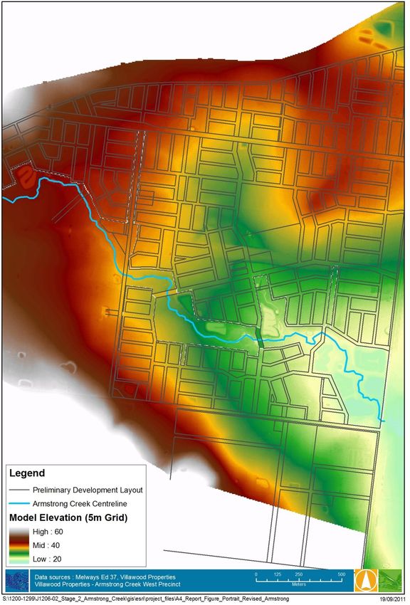
J1206-02 / R01 v07 Stage 24 October 2011 15Villawood – Armstrong Creek West Precinct Flooding investigations – Stage 2 The flood extent and maximum depth for the 100 year flood events under developed conditions is shown in Figure 3-5 below. A WSE plot and 0.5 m contours are shown in Figure 3-6. Many of the overland flow paths observed in the existing conditions flood extent have been constrained by the fill pads. Flood extents for the other ARI events modelled are shown in Appendix A. Deeper flood waters (greater than 0.5 m) were observed in the wetlands and sediment basins, and also upstream of the Surf Coast Highway and the proposed road crossings. Shallow flow (less than 0.2 m shaded yellow and pale blue) was seen in most other areas. No flow is seen across the Surf Coast Highway in either event, an improvement from existing conditions. Note that the area of pooling upstream of the eastern proposed road crossing occurred because the road crossing was constricted to 2 no. 3 x 1.5m culverts. This allows the 100 year developed flow to be attenuated below the existing peak flow by using the storage behind the road crossing embankment. This arrangement was varied through the model runs to achieve an acceptable head drop across the road crossing while also attenuating the required volume. J1206-02 / R01 v07 Stage 24 October 2011 16
Villawood – Armstrong Creek West Precinct
Flooding investigations – Stage 2

Figure 3-5    Design flood levels and extents – 100 year developed catchment conditions

J1206-02 / R01 v07 Stage 24 October 2011                                                  17
Villawood – Armstrong Creek West Precinct
Flooding investigations – Stage 2

Figure 3-6    Water Surface Elevation (WSE) plot and 50cm contours – 100 year developed conditions

J1206-02 / R01 v07 Stage 24 October 2011                                                   18
Villawood – Armstrong Creek West Precinct
Flooding investigations

The flow hydrographs at Airport Road and Surf Coast Highway were extracted from the model and
are shown in Figure 3-7 below. The 100 year ARI peak flows at Airport Road and Surf Coast Highway
under existing and developed conditions are summarised in Table 3-5 below. The results show a
decrease in flows observed at Airport Road when compared to existing conditions and a small
increase at Surf Coast Highway. The flows measured at the Highway were weighed up against the
head drop across the culvert constriction, with the goal of limiting the head loss to less than 500mm.
The results shown in Figure 3-8 indicate that the head drop is restricted to approximately 500mm as
flow is constricted through the 2 no. 1.5 x 3m culverts. The flow rate at Surf Coast Highway could be
reduced further by increasing the culvert constriction and hence increasing the head drop across the
road. Alternatively, increasing the available retarding basin storage within the ACWP or allowing
more confined flooding of the Highway in the 100 year ARI event would also reduce flow rates at the
Highway, although the latter option would be likely to pose a safety risk to road users.
With the water surface at 28.3m AHD upstream of the culvert, approximately 3,000m3 of fill will be
required on the two properties on either side of the creek immediately adjacent to the culvert when
assuming a 300mm freeboard requirement.
Given the hydrology error margins, and possible mitigation techniques the current proposed
mitigation is considered an acceptable solution for the proposed development.

                      28

                      24

                      20
   Flow Rate (m3/s)

                      16

                                                                                               Surf Coast Highway
                      12
                                                                                               Airport Rd

                       8

                       4

                      0
                      12:00:00        18:00:00      0:00:00       6:00:00      12:00:00
                                                     Hours

Figure 3-7                       100 year ARI 12 hour duration hydrographs (m3/s) at Airport Road and Surf Coast
                                 Highway under developed conditions

J1206-02 / R01 v07 Stage 24 October 2011                                                                        19
Villawood – Armstrong Creek West Precinct
Flooding investigations
Table 3-5 Existing and Developed Peak Flows at Airport Road and Surf Coast Highway
Airport Road peak Surf Coast Highway
flow (m3/s) peak flow (m3/s)
Existing Conditions 15.8 24.0
Developed Conditions 12.4 25.3
Difference (Existing v. Developed) - 27% + 5%
J1206-02 / R01 v07 Stage 24 October 2011 20Villawood – Armstrong Creek West Precinct
Flooding investigations
Figure 3-8 Water Surface Elevations (WSE) at the culvert constriction showing a head drop of
approximately 500mm
J1206-02 / R01 v07 Stage 24 October 2011 21Villawood – Armstrong Creek West Precinct
Flooding investigations
4. CONCLUSIONS AND ASSUMPTIONS
This study has shown the comparison between existing and developed conditions hydrological and
hydraulic modelling with the aim of limiting flows at Airport Road and Surf Coast Highway to existing
conditions.
The following conclusions can be made:
- The results show that through the use of wetland/retarding basins, culvert constrictions and
a low wall along the Surf Coast Highway; the 100 year ARI flows in developed conditions
when compared with existing conditions are significantly less at Airport Road and slightly
higher at Surf Coast Highway. The works proposed have the added benefit of protecting the
Surf Coast Highway from inundation in the 100 Year ARI event which is flooded to depths up
to 300mm in existing conditions;
- Large head drops at culvert constrictions have been eliminated and limited to a maximum of
500mm; and
- The wetlands have been located at the most suitable locations to minimise vegetation loss
whilst maintaining quality and quantity objectives.
The following assumptions have been made:
- All information provided to Water Technology regarding the proposed development layout
is up to date at the time of the publishing of this report;
- Sedimentation Basin 1 shown in earlier reporting has been removed;
- Existing drainage crossings of the Railway line will remain into the future as the only external
catchment flow inputs to the ACWP;
- The existing flood storage available at the Airport behind the east-west runway will be
removed as part of the redevelopment and hence its storage capacity is removed;
- All other existing retarding basins outside the study are that contribute to the flows passing
through the site will remain in place; and,
- Drainage layouts will broadly follow the existing road boundaries and natural fall of the land.
J1206-02 / R01 v07 Stage 24 October 2011 22Villawood – Armstrong Creek West Precinct Flooding investigations 5. REFERENCES Bonacci Water 2008. Stormwater Management Strategy for Armstrong Creek – Analysis of Integrated Stormwater and WSUD Options. July 2008. Corangamite Catchment Managment Authority 2009. Armstrong Creek Catchment Hydroloigcal Flood Study - Draft C. 31 March 2009. Neil M Craigie, 2011. Armstrong Creek West Precinct (ACWP) Stormwater Management Strategy, Version 1 – Draft. 23 September, 2011. Water Technology 2007. Armstrong Creek Urban Growth Plan – Flooding and Drainage Investigations. Draft C. June 2007. Water Technology and Neil M Craigie (2010). Armstrong Creek West Precinct Structure Plan Flooding Investigations: Stage 1. November 2010. J1206-02 / R01 v07 Stage 24 October 2011 23
Villawood – Armstrong Creek West Precinct
Flooding investigations

APPENDIX A                   FLOOD EXTENTS FOR REMAINING
                             ARIs

J1206-02 / R01 v07 Stage 24 October 2011                   24
Villawood – Armstrong Creek West Precinct Flooding investigations Figure A - 1 Design flood levels and extents – 10 year developed catchment conditions J1206-02 / R01 v07 Stage 24 October 2011 25
Villawood – Armstrong Creek West Precinct
Flooding investigations

J1206-02 / R01 v07 Stage 24 October 2011    26
You can also read