Site Specific Flood Risk Assessment Alterations to Shoreline GA01 Lands at Baldoyle Stapolin Growth Area 1, Baldoyle, Co. Dublin

Page created by Tracy Dixon
 
CONTINUE READING
Site Specific Flood Risk Assessment Alterations to Shoreline GA01 Lands at Baldoyle Stapolin Growth Area 1, Baldoyle, Co. Dublin
Site Specific Flood Risk Assessment

Alterations to Shoreline GA01
Lands at Baldoyle

Stapolin Growth Area 1, Baldoyle,
Co. Dublin

Client: The Shoreline Partnership

Job No. R089

May 2021
Site Specific Flood Risk Assessment Alterations to Shoreline GA01 Lands at Baldoyle Stapolin Growth Area 1, Baldoyle, Co. Dublin
SITE SPECIFIC FLOOD RISK ASSESSMENT

              ALTERATIONS TO SHORELINE GA01 LANDS AT BALDOYLE
               STAPOLIN GROWTH AREA 1, BALDOYLE, CO. DUBLIN

                                         CONTENTS

1.0   INTRODUCTION ___________________________________________________________ 1

2.0   SITE LOCATION AND PROPOSED DEVELOPMENT _____________________________ 2

3.0   PROCESS FOR SITE SPECIFIC FLOOD RISK ASSESSMENT _______________________ 5

4.0   LEVEL OF SERVICE_________________________________________________________ 7

5.0   FLOOD RISKS & MITIGATION MEASURES ____________________________________ 10

      ITEMS RAISED BY FINGAL COUNTY COUNCIL _______________________________ 18

      CONCLUSION ___________________________________________________________ 20

      CONCLUSION AND RECOMMENDATIONS _________________________________ 21

Appendix A:   Fingal County Council Flood Zone Mapping
Appendix B:   Office of Public Works Historic Flood Report
Appendix C:   Fingal East Meath Flood Risk Assessment and Management (FEM FRAM) Fluvial
              Flood Extent Map
Appendix D:   Fingal East Meath Flood Risk Assessment and Management (FEM FRAM) Tidal
              Flood Extent Map
Appendix E:   Irish Coastal Protection Strategy Study – Phase III – North East Coast Flood Extent
              Map
Appendix F:   Geological Survey of Ireland – Hydrogeology & Bedrock Geology Maps

                                             R089
Site Specific Flood Risk Assessment Alterations to Shoreline GA01 Lands at Baldoyle Stapolin Growth Area 1, Baldoyle, Co. Dublin
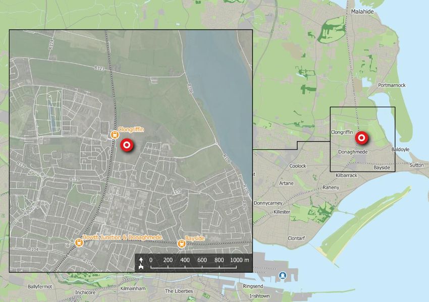
This Report has been prepared by CS Consulting for the benefit of its Client only. The contents of this
Report are shared with interested parties for information only and without any warranty or guarantee,
express or implied, as to their accuracy, reliability or completeness. This Report cannot be relied on by
any party other than the party who commissioned it.

File Location: Job-R089\B_Documents\C_Civil\A_CS Reports\FRA
BS 1192 FIELD        BD-CSC-ZZ-XX-RP-C-0102-P5

Job Ref.        Author             Reviewed By        Authorised By       Issue Date       Rev. No.

R089            PS                 GL                 OS                  07.05.2021             P5

R089            PS                 GL                 OS                  16.04.2021             P4

R089            PS                 GL                 OS                  01.03.2021             P3

R089            GS                 GL                 OS                  27.05.2020             P2

R089            GS                 GL                 OS                  15.05.2020             P1
Site Specific Flood Risk Assessment Alterations to Shoreline GA01 Lands at Baldoyle Stapolin Growth Area 1, Baldoyle, Co. Dublin
1.0    INTRODUCTION

       Cronin & Sutton Consulting Engineers (CS Consulting) have been
       commissioned by The Shoreline Partnership to prepare a Site Specific Flood
       Risk Assessment to accompany a planning application for a proposed
       mixed residential development at Baldoyle, Dublin 13.

       In preparing this report, CS Consulting has made reference to the following:

        •   Fingal County Council Development Plan 2017–2023;
            (including Strategic Flood Risk Assessment)
        •   Baldoyle-Stapolin Local Area Plan
        •   Greater Dublin regional Code of Practice for Works;
        •   Office of Public Works Flood Maps;
        •   Department of the Environment Flooding Guidelines;
        •   Geological Survey of Ireland Maps;
        •   Local Authority Drainage Records.

       The Site Specific Flood Risk Assessment has been carried out in accordance
       with ‘Planning System and Flood Risk Management – Guidelines for Planning
       Authorities (2009)” and is to be read in conjunction with the engineering
       drawings and documents submitted by CS Consulting and with the various
       additional information submitted by the other members of the design team,
       which forms part of the Planning Submission.

R089 Site Specific Flood Risk Assessment                                       1
Site Specific Flood Risk Assessment Alterations to Shoreline GA01 Lands at Baldoyle Stapolin Growth Area 1, Baldoyle, Co. Dublin
2.0   SITE LOCATION AND PROPOSED DEVELOPMENT

2.1   Site Location

      The proposed development site is located at Stapolin Growth Area 1,
      Baldoyle, Co. Dublin, in the administrative jurisdiction of Fingal County
      Council. The site has a total site area of c. 9.1ha and a site development
      area of c. 8.89ha.

                  Figure 1 – Location of proposed development site
                  (map data & imagery: EPA, OSM Contributors, Google)

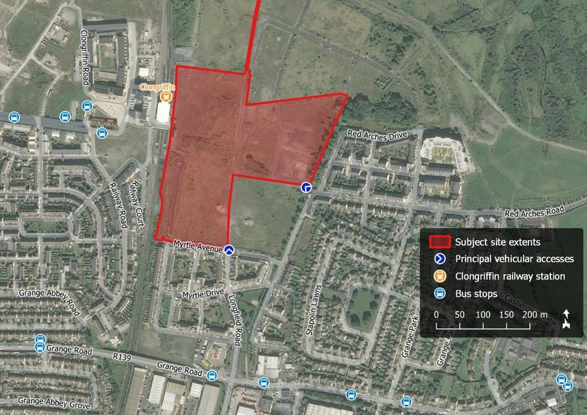
      The location of the proposed development site is shown in Figure 1 above;
      the indicative extents of the development site, as well as relevant elements
      of the surrounding road network, are shown in more detail in Figure 2.

      The site is bounded to the west by the Dublin-Belfast railway line, with
      Clongriffin DART Station located just to the north west of the applicant
      lands, to the east by the Red Arches and Stapolin Lawns residential

  2                                      R089 Site Specific Flood Risk Assessment
Site Specific Flood Risk Assessment Alterations to Shoreline GA01 Lands at Baldoyle Stapolin Growth Area 1, Baldoyle, Co. Dublin
developments, to south by the Myrtle residential development. To the north,
       the applicant site is bounded by future development lands known as
       Growth Area 3 (GA3).

                           Figure 2 – Site extents and environs
                 (map data & imagery: NTA, OSi, OSM Contributors, Google)

2.2    Existing Land Use

       The subject site is a greenfield and currently undeveloped.

2.3    Proposed Development

       The development will consist of alterations to the permitted development,
       as permitted under FCC Reg. Ref. 16A/0412, ABP Reg. Ref. ABP-248970 (as
       amended by F20A/0258 and F21A/0046) of 546no. residential units (385no.
       apartments and 161no. houses), retail and a crèche, to the development
       of 882no. new residential dwellings (747no. apartments, 135no. houses),

R089 Site Specific Flood Risk Assessment                                      3
Site Specific Flood Risk Assessment Alterations to Shoreline GA01 Lands at Baldoyle Stapolin Growth Area 1, Baldoyle, Co. Dublin
residential tenant amenity, retail, crèche, parking, and public realm, over a
    total site area of c. 9.1ha, and site development area of c. 8.89ha.

    Landscaping will include extensive communal amenity areas, and
    significant public open space provision.

4                                       R089 Site Specific Flood Risk Assessment
Site Specific Flood Risk Assessment Alterations to Shoreline GA01 Lands at Baldoyle Stapolin Growth Area 1, Baldoyle, Co. Dublin
3.0    PROCESS FOR SITE SPECIFIC FLOOD RISK ASSESSMENT

      The initial stage of the SSFRA comprises an assessment of available flood risk
      data in order to identify flood risk indicators in the Study Area. If the Site is
      identified to be at risk of flooding, the SSFRA shall proceed to a detailed
      assessment.

3.1    POTENTIAL SOURCES OF FLOOD RISK

      The Study Area is subject to the three potential flood risk mechanisms
      described below (as an inland site, the Study Area is not subject to coastal
      flood risk).

      Fluvial: flooding caused by overtopping of Rivers and Streams;

      Tidal: flooding caused by coastal sea level rises

      Pluvial: flooding caused when the intensity of rainfall events is such that the
      ground cannot absorb rainfall run-off effectively or urban drainage systems
      cannot carry the run off generated;

      Groundwater: flooding caused by a rise in the level of the water table.

3.2    FLOOD RISK INDICATORS

      Indicators of flood risk are identified using available data, most of which is
      historically derived. Typically, this data is not prescriptive in relation to flood
      return periods and neither predictive nor inclusive of climate change
      analysis.

      Flood risk indicators include:

          •   Records available on the OPW’s National Flood Risk Website. As part
              of the National Flood Risk Management Policy, the OPW developed
              the www.floodmaps.ie web-based data set, which contains

R089 Site Specific Flood Risk Assessment                                             5
Site Specific Flood Risk Assessment Alterations to Shoreline GA01 Lands at Baldoyle Stapolin Growth Area 1, Baldoyle, Co. Dublin
information concerning historical flood data and displays related
        mapped information and provides tools to search for and display
        information about selected flood events;
    •   PFRA & CFRAM mapping produced under the OPW CFRAM
        programme;
    •   Geological Survey of Ireland (GSI) mapping - Hydrogeological
        mapping maintained by the GSI and made available through its
        website www.gsi.ie;
    •   Ordnance Survey mapping - Ordnance Survey maps include areas
        which are marked as being “Liable to Floods”. Generally, these areas
        are only shown identified indicatively and suggest historical flooding,
        usually recurrent. In addition, the maps indicate areas of wet or
        hummocky ground, bog, marsh, springs, rises and wells as well as
        surface water features including rivers, streams, bridges, weirs and
        dams. Figure 4.1 shows the historic 6” OS mapping for the Study Area;
    •   Topographical survey information;
    •   Ground Investigation information;

6                                    R089 Site Specific Flood Risk Assessment
4.0    LEVEL OF SERVICE

      There is an existing inherent risk of any flood event occurring during any
      given year. Typically, this likelihood of occurrence was traditionally
      expressed as a 1-in-100 chance of a 100 year storm event happening in any
      given year.

      A less ambiguous expression of probability is the Annual Exceedance
      Probability (AEP), which may be defined as the probability of a flood
      event being exceeded in any given year. Therefore a 1-in-100-year event
      has a return period of 1% AEP flood event, similarly a 100% AEP can be
      expressed as a 1-in-1-year event.

       The Planning System and Flood Risk Management, Guidelines for Planning
       Authorities set out the best practice standards for flood risk assessment in
       Ireland. These are summarized in Table 1.

       Flooding Source        Drainage         River         Tidal/Coastal
       Residential             1% AEP        0.1% AEP          0.1% AEP
       Commercial              1% AEP         1% AEP           0.5% AEP
       Water-compatible           -           >1% AEP         >0.5% AEP
       (docks, marinas)

                Table 1 – Summary of Level of Service – Flooding Source

      Under these guidelines a proposed development site has first to be assessed
      to determine the flood zone category it falls under.

       It is a requirement of both Fingal County Council, Greater Dublin Strategic
       Drainage Study, (DCC 2005) & the Department of the Environment,
       community & Local Government flooding guidelines, The Planning System
       and Flood Risk Management, Guidelines for Planning Authorities, that the

R089 Site Specific Flood Risk Assessment                                       7
predicted effects of climate change are incorporated into any proposed
    design. Table 2 below indicates the predicted climate change variations.

        Design Category            Predicted Impact of Climate Change
        Drainage                           10% Increase in rainfall
        Fluvial (River flows)            10% Increase in flood flow
        Tidal / Coastal         Minimum Finished Floor Level 4.0 – 4.15m AOD

                    Table 2 - The predicted climate change variations.

    The flooding guidelines categorize the risks associated with flooding into
    three areas, Zone A, B & C. This categorisation is indicated below.

    •    Zone A – High Probability of Flooding. Where the average probability of
         flooding from rivers and sea is highest (greater than 1% annually or 1 in
         100 for river flooding or 0.5% annually or 1 in 200 for coastal flooding).

    •    Zone B – Moderate Probability of Flooding. Where the average
         probability of flooding from rivers and sea is moderate (risk between
         0.1% annually or 1 in 1000 years and 1% annually or 1 in 100 years for river
         flooding, and between 0.1% or 1 in 1000 years and 0.5% annually or 1 in
         200 for coastal flooding).

    •    Zone C – Low Probability of Flooding. Where the probability of flooding
         from rivers and sea is moderate (risk is less than 0.1% annually or 1 in 1000
         years for both rivers and coastal flooding).

    In accordance with the Planning Systems and Flood Risk Management
    Guidelines for Planning Authorities, dwellings are classified as ‘highly
    vulnerable developments’.

8                                           R089 Site Specific Flood Risk Assessment
Figure 3 – Source-pathway-receptor model
            (imagery: The Planning System and Flood Risk Management Guidelines)

       The flooding guidelines have developed an ‘appropriateness’ matrix for
       various developments and their potential risk factor. The table indicates if
       further analysis is required in the form of a justification test. Table 3 below
       outlines the conditions that require a justification test.

                                 Flood Zone A          Flood Zone B       Flood Zone C
         Highly Vulnerable
                                Justification Test   Justification Test   Appropriate
           Development

          Less Vulnerable
                                Justification Test     Appropriate        Appropriate
           Development

        Water-compatible
                                  Appropriate          Appropriate        Appropriate
           Development

                      Table 3 - Flood Zone Vs Justification Test Matrix

R089 Site Specific Flood Risk Assessment                                          9
5.0    FLOOD RISKS & MITIGATION MEASURES

5.1    Fluvial Flooding

      5.1.1      Flood Risk Indicators

       The following were interrogated for indicators of fluvial flood risk:

       •      The OPW maintains the National Flood Hazard Mapping website which
              contains information about locations that may be at risk from flooding.
              The source of this information includes Local Authorities and other
              historic records such as newspaper articles and other documentation
              about reported floods. There is no evidence of any recorded flood
              events at the subject Site (a copy of the summary report is included in
              Appendix B).

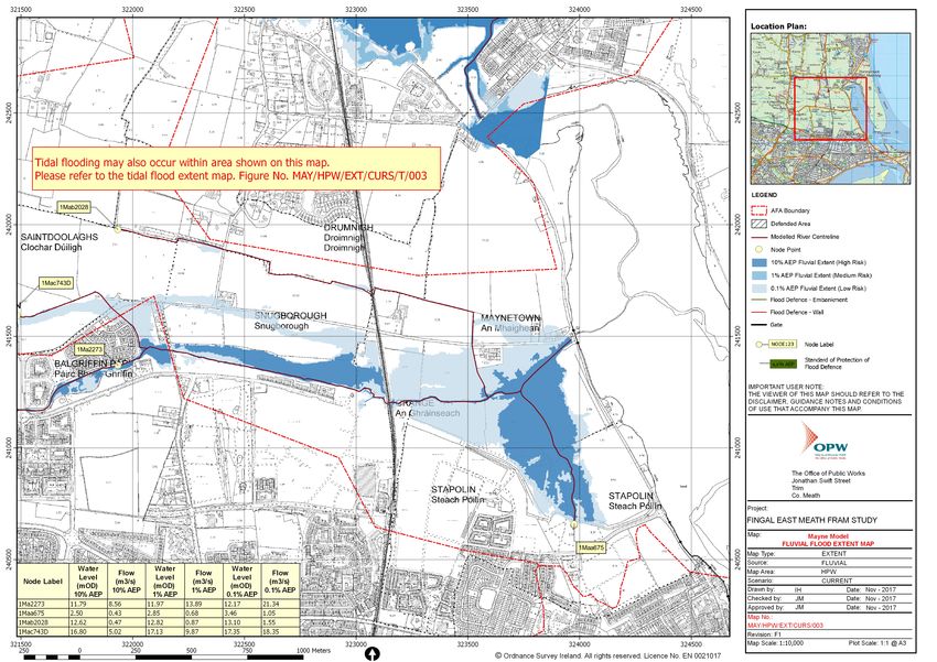
       •      The River Mayne is located to the north of the subject site. The Fingal
              East Meath Flood Risk Assessment and Management Study (FEM FRAMS)
              2017, conducted by the OPW, indicates that the subject site is deemed
              to be located outside of the 0.1% AEP fluvial floodplain, based on the
              currently available maps, see Appendix C. The nearest node point
              indicates a flood level of 3.46m AOD for the 1000-year flood level. The
              proposed levels of the development are in excess of 5.0m AOD and
              therefore the site’s location is such that it is not affected by fluvial
              flooding from the River Mayne.

              From the above referenced maps, the flood plain of the River Mayne
              currently only reaches the northern boundary of the development lands
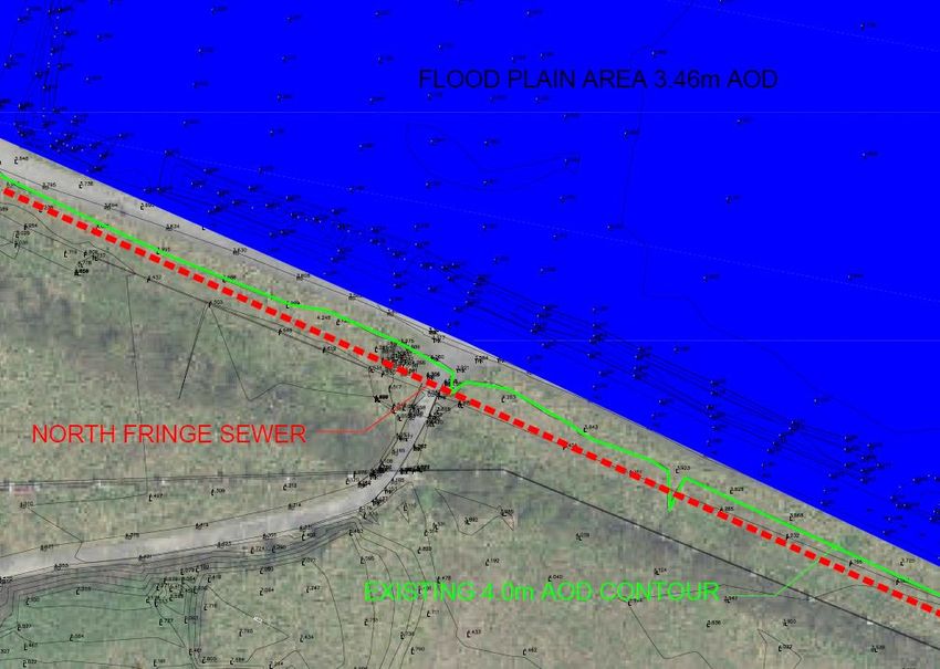
              where the existing North Fringe Sewer is located. The existing levels
              around the North Fringe Sewer are in excess of 4.0m AOD. No
              development is to take place in and around the area of the sewer (with
              the exception of a new storm outfall pipe crossing the sewer) and the
              existing levels are to be retained, therefore there shall be no loss of
              existing river floodplain in the area, see figure 4

 10                                             R089 Site Specific Flood Risk Assessment
Figure 4 – Floodplain adjacent to North Fringe Sewer

       •     Historical Ordnance Survey OS maps for the subject site do not show any
             indicators of flood risk.

     5.1.2     Impact of Proposed Development On Fluvial Flood Regime

      The proposed development shall change rainfall run-off patterns within the
      subject site. This has the potential to alter the existing flow regime in
      watercourses to which run-off from the undeveloped site discharges. In
      particular, it has the potential to increase the rate of run-off during more
      extreme rainfall events.

      Surface water drainage from the development shall be disposed of using
      two mechanisms:

      (i) infiltrate run-off to the ground using SuDS measures such as Wetlands,
      swales, permeable paving, bio-retention areas, green roof etc;

R089 Site Specific Flood Risk Assessment                                        11
(ii)discharge run-off to a receiving floodplain; it is proposed to utilise the
      existing floodplain to the north to provide flood storage for the site, and this
      strategy is in accordance with the requirements of the LAP (Appendix 1,
      section 4.3). After entering the proposed wetland, this volume shall overspill
      the weir/spillway into the existing floodplain resulting in a nominal increase
      across the 40 Ha floodplain of the order of 10mm. The greenfield runoff from
      the current undeveloped site would result in an approximate contribution
      of 5mm to the floodplain, hence the increase in depth to the floodplain as
      a result of the development is of the order of 15mm. This increase is
      negligible and would not result in any impact on development as it is not
      permitted within the floodplain. There are also no existing properties or
      structures at risk within the floodplain.

      These mechanisms are consistent with best practice for the sustainable
      urban drainage and the design has been carried out in accordance with
      the Greater Dublin Strategic Drainage Study (GDSDS). Compliance with
      GDSDS ensures surface water run-off from the proposed development shall
      not affect the flood regime in the receiving watercourse. On this basis, the
      surface water drainage system shall not cause an increase in fluvial flood
      risk.

     5.1.3    Results of Initial Assessment

      The available data described above does not provide any indication of
      fluvial flood risk in the Study Area. Therefore, in accordance with ‘Planning
      System and Flood Risk Management – Guidelines for Planning Authorities
      (2009)’ a detailed assessment of this flooding mechanism is not required.

12                                            R089 Site Specific Flood Risk Assessment
5.2    Tidal Flooding

      5.2.1      Flood Risk Indicators

       •      The OPW maintains the National Flood Hazard Mapping website which
              contains information about locations that may be at risk from flooding.
              The source of this information includes Local Authorities and other
              historic records such as newspaper articles and other documentation
              about reported floods. There is no evidence of any recorded flood
              events at the subject Site (a copy of the summary report is included in
              Appendix B).

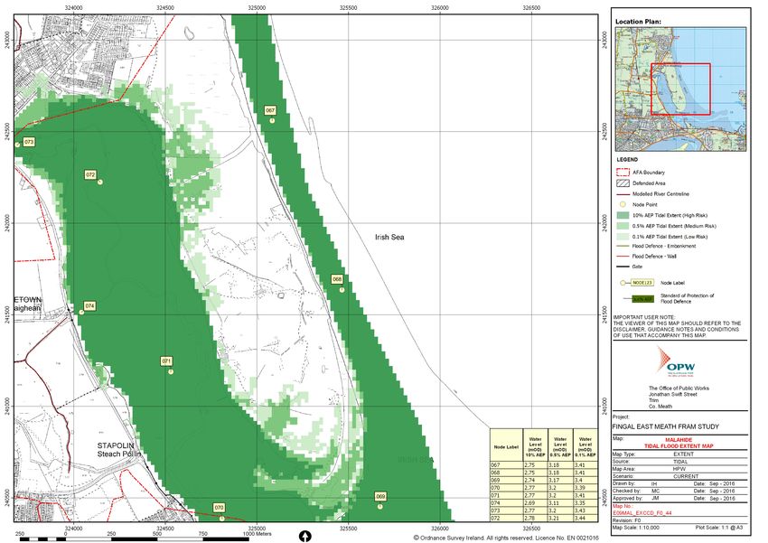
       •      The subject site proximity to the coast indicates that the potential for on-
              site flooding due to tidal action needs to be considered. Recent
              modelling of the area as part of the FEM FRAMS 2016, indicates that the
              subject site is deemed to be located outside the 0.5% AEP tidal
              floodplain based on the currently available maps, see Appendix D.

       •      The coast of Ireland has also been modelled by the OPW as part of the
              Irish Coastal Protection Strategy Study – Phase 3. This study looked at the
              potential future flooding should climate change have a dramatic effect
              on sea levels. The study took a ‘mid-range’ level for sea level rise of
              500mm above current levels and a ‘high end’ level of 1000mm above
              existing levels and then re-modelled the effects. The effects indicate
              that the site would be outside of the flooded area. See Appendix E for
              ICPSS Maps.

       •      Historical Ordnance Survey OS maps for the subject site do not show any
              indicators of flood risk.

       The nearest node point to the development site indicates a flood level of
       3.35m AOD. The proposed levels of the development are in excess of 5.0m

R089 Site Specific Flood Risk Assessment                                             13
AOD and therefore the sites location is such that it is not affected by tidal
       water flooding.

      5.2.2      Results of Initial Assessment

       The available data described above does not indicate the risk of tidal
       flooding on the development site. Therefore, in accordance with ‘Planning
       System and Flood Risk Management – Guidelines for Planning Authorities
       (2009)’ a detailed assessment of this flooding mechanism is not required.

5.3    Pluvial Flooding

      5.3.1      Flood Risk Indicators

       •      The OPW maintains the National Flood Hazard Mapping website which
              contains information about locations that may be at risk from flooding.
              The source of this information includes Local Authorities and other
              historic records such as newspaper articles and other documentation
              about reported floods. There is no evidence of any recorded flood
              events at the subject Site (a copy of the summary report is included in
              Appendix B).

       Pluvial flooding is flooding which has originated from overland flow resulting
       from high intensity rain fall. The historical and predicted flooding information
       does not indicate that the subject lands are at risk from pluvial flood events.

5.4    Surface Water Drainage for The Proposed Development

       The proposed surface water strategy and drainage design for the
       development are outlined within the Engineering Services Report, that
       accompanies this planning application. In summary, road drainage is
       collected by bio-retention areas, swales or gullies and roofs are drained to
       filter drains located in rear gardens. All surface water then discharges into
       the new surface water sewer network which outfalls to proposed wetland

 14                                              R089 Site Specific Flood Risk Assessment
(providing water quality treatment) before over-spilling a weir/spillway to
       the Mayne River Floodplain, note Wetland area granted planning under
       F16A/0412.

       As per the above referenced grant of permission, it is proposed to utilise the
       existing floodplain to the north to provide flood storage for the site, and this
       strategy is in accordance with the requirements of the LAP (Appendix 1,
       section 4.3). The total volume of runoff for the critical 1 in 100-year (6-hour)
       storm has been calculated as 3600m3. After entering the proposed
       wetland, this volume shall overspill the weir/spillway into the existing
       floodplain resulting in a nominal increase across the 40 Ha floodplain of the
       order of 10mm. The greenfield runoff from the current undeveloped site
       would result in an approximate contribution of 5mm to the floodplain,
       hence the increase in depth to the floodplain as a result of the
       development is of the order of 15mm. This increase is negligible and would
       not result in any impact on development as it is not permitted within the
       floodplain. There are also no existing properties or structures at risk within the
       floodplain. After the tide recedes, this water shall then flow back into the
       sea on its existing natural path.

       The proposed surface water network discharging to the flood plain has an
       invert level of 3.7m AOD as it crosses into the floodplain backdrops to a level
       of 2.95m AOD and falls gently to an invert level of circa 2.7m AOD before
       discharging to the constructed wetland. The maximum flood level of the
       floodplain is circa 3.46m AOD, therefore an overflow pipe shall be installed
       at an invert of 3.5m AOD to the floodplain, meaning that in the event of the
       floodplain is flooded the proposed development shall continue to
       discharge and not surcharge the upstream network and cause flooding to
       the proposed residential development.

       In regard to flood exceedance, storms less than the 1 in 100-year pluvial
       event, shall be catered for within the development’s drainage network.

R089 Site Specific Flood Risk Assessment                                            15
However, in the rare occurrence of a higher storm (or a blockage within the
       system) capacity in the drainage network shall be exceeded and areas
       with lower road levels shall begin to flood. Proposed road levels are
       designed to low spots within the proposed site, which are located away
       from the proposed development structures, any above ground flooding
       shall therefore gather at these locations. Overland flows generated by any
       potential flooding of manholes and gullies or from high intensity, short
       duration storms which might fail to enter the drainage system, shall be
       routed away from buildings and towards open spaces within the site. Drop
       kerbs shall be provided at road edges at low spots in order to allow
       overland flow to enter these areas. (Please note. the drainage network of
       the development is designed to include for a 10% increase in flows due to
       climate change)

       Please refer to the CS Consulting Engineering Services Report for more
       details.

5.5    Results of Initial Assessment

       Based on the above, there is no indication of pluvial flood risk to the subject
       site. Therefore, in accordance with ‘Planning System and Flood Risk
       Management – Guidelines for Planning Authorities (2009)’ a detailed
       assessment of this flooding mechanism is not required.

5.6    Groundwater Flooding

      5.6.1   Flood Risk Indicators

       According to the Geological Survey of Ireland (GSI) interactive maps, the
       subject site indicates no karst features are in the area, that groundwater
       vulnerability is low, and the aquifer is poor. The proposed alteration to the
       existing site shall not increase the potential for groundwater flooding as such

 16                                         R089 Site Specific Flood Risk Assessment
the risk is deemed acceptable. See Appendix F for GSI mapping information
      for background groundwater & geology data for the subject site.

     5.6.2   Results of Initial Assessment

      Based on the above, there is no indication of groundwater flood risk to the
      subject site. Therefore, in accordance with ‘Planning System and Flood Risk
      Management – Guidelines for Planning Authorities (2009)’ a detailed
      assessment of this flooding mechanism is not required.

R089 Site Specific Flood Risk Assessment                                     17
ITEMS RAISED BY FINGAL COUNTY COUNCIL

      Following the initial submission to An Bord Pleanala, Fingal Co Co issued their
      Opinion Statement in regards to the proposed development. Outlined
      below are the main items raised in Section 8.3.8.1 Flood Risk, of the Fingal
      Co Co Opinion together with an appropriate response to the points raised.

     6.1.1    Flood Exceedance Route

     As mentioned in Section 5.4 above, the surface water network for the
     development has been designed to cater for a 100 year storm event (plus
     climate change), meaning no flooding shall occur on site, as all stormwater
     shall be catered for within the manholes, pipelines etc of the surface water
     network.

     In the rare occurrence of a higher storm (or a blockage within the system)
     above a 100 year event, capacity in the drainage network shall be
     exceeded and excess stormwater shall emerge from manholes or gullies.

     The proposed road levels across the scheme have been designed and
     superelevated to ensure excess floodwater is routed away from the
     proposed development structures, towards open spaces around the
     development where the excess stormwater can pond and eventually drain
     to ground or back into the surface water network once the storm event
     eases.

     Please see drawing BD-CSC-ZZ-00-DR-C-0037 that indicates the flood exceed
     routes across the development site.

18                                         R089 Site Specific Flood Risk Assessment
6.1.2    1000-year Flood Level against Existing Site Levels

     Fingal Co Co requested an exercise be carried out to compare the existing
     1000 year flood level against the existing pre-development topographical
     site levels. Please see drawing BD-CSC-ZZ-00-DR-C-0038 that indicates the
     existing topographical levels along the northern boundary of the
     development site superimposed onto the relevant CFRAMS flood map.

     The existing contour level of 4.5m AOD is highlighted (Black) which is over
     1.0m above the 1000 year flood level of 3.46m AOD (flood area hatched as
     blue). This drawing confirms the existing site, and its topographical levels are
     well in excess of the 1000 year flood levels, prior to any development taking
     place.

     6.1.3    Flood Risk due to Tidal Lock

     As mentioned previously the 1000 year flood level to the north of the
     development site in the tidal estuary is 3.46m AOD. Following detailed
     discussions with Irish Water the proposed surface water network must cross
     above the existing 9C sewer to the north of the development site. Following
     consultation with Irish Water the proposed storm pipe shall cross above the
     9C sewer above 3.7m AOD (please refer to Engineering Services Report
     under separate cover). Once over the 9C sewer the drainage network
     backdrops to a level of 2.95m AOD via a manhole (Manhole S1A on drawing
     BD-CSC-ZZ-00-DR-C-0004) before discharging to the constructed wetland.

     In the event that the wetlands and the outfall to it are submerged due to the
     level of flood water in the estuary, the hydraulic head of water in Manhole
     S1A from its upstream network shall force surface water in the network out
     into the estuary and shall be no affect to the scheme in regards to tidal lock.

R089 Site Specific Flood Risk Assessment                                        19
CONCLUSION

     7.1.1   Fluvial Flood Risk

      There were no indicators of fluvial flood risk associated with the
      development site and therefore, in accordance with ‘Planning System and
      Flood Risk Management – Guidelines for Planning Authorities (2009)’ [the
      ‘FRM Guidelines’] detailed assessment of this flooding mechanism is not
      required.

     7.1.2   Tidal Flood Risk

      The available data described above does not indicate the risk of tidal
      flooding on the development site. Therefore, in accordance with ‘Planning
      System and Flood Risk Management – Guidelines for Planning Authorities
      (2009)’ a detailed assessment of this flooding mechanism is not required.

     7.1.3   Pluvial Flood Risk

      The pluvial flood-risk indicators described in Section 5.3 do not provide any
      indication of pluvial flooding at the subject site and therefore, in
      accordance with ‘Planning System and Flood Risk Management –
      Guidelines for Planning Authorities (2009)’ [the ‘FRM Guidelines’] detailed
      assessment of this flooding mechanism is not required.

     7.1.4   Flood Risk from Ground Water

      Geological Survey of Ireland (GSI) interactive maps do not provide any
      indication of flood risk from groundwater at the subject site and therefore,
      in accordance with ‘Planning System and Flood Risk Management –
      Guidelines for Planning Authorities (2009)’ [the ‘FRM Guidelines’] detailed
      assessment of this flooding mechanism is not required.

20                                        R089 Site Specific Flood Risk Assessment
CONCLUSION AND RECOMMENDATIONS

       The proposed development was subject to SSFRA in accordance with OPW
       Flood Risk Management Guidelines. This SSFRA did not find any indicators of
       the proposed development being at risk from fluvial, pluvial or groundwater
       flooding; also, the SSFRA did not find any indicators that the proposed
       development shall give rise to flood risk elsewhere.

R089 Site Specific Flood Risk Assessment                                      21
Appendix A

Fingal County Council Flood Zone Mapping

   R089 Site Specific Flood Risk Assessment
Legend

¯                                 Watercourses
                                  Fingal County Boundary
                                  Defended Area
                                  Flood Zone A - 1% AEP (Fluvial) or
                                  0.5% AEP (Coastal) Flood Extent
                                  (1 in 100 chance in any given year)
                                  Flood Zone B - 0.1% AEP Flood Extent
                                  (1 in 1000 chance in any given year)
                                  Indicative Flood Extents

    SITE LOCATION
                                                              01          02

                                          03          04           05            06

                                          07          08           09            10

                                                    11         12           13

                                          14             15         16           17

                                     18          19           20            21
                                                                                      22
                                    23          24

                         Client

                         Project

                           Strategic Flood Risk Assessment

                         Title

                                  Flood Zone Mapping
                         Figure                 Map 21 of 24
                                                           West Pier Business Campus,
                                                           Dun Laoghaire,
                                                           Co Dublin,
                                                           Ireland.

                                                           Tel: +353 (0) 1 4882900
                                                           Fax: +353 (0) 1 2835676
                                                           Email: ireland@rpsgroup.com
                                                           Web Page: rpsgroup.com/ireland

                           Issue Details
                         Drawn By:       BT                   Project No.      MDW0716

                         Checked By: BC                       File Ref:

                                                              MDW0716arc0001D03
                         Approved By: PM
                    21
                         Scale:    1: 20,000 @ A3             Drawing No.             Rev:

                         Date:     08/03/2017                 Arc0001                 A01

                         NOTE: 1. This drawing is the property of RPS Group Ltd. It is a
                                  confidential document and must not be copied, used,
                                  or its contents divulged without prior written consent.
                               2. All levels are referred to Ordnance Datum, Malin Head.
                               3. Ordnance Survey Ireland Licence No. EN 0005017
                               © Ordnance Survey Ireland/Government of Ireland
Appendix B

Office of Public Works Historic Flood Report

   R089 Site Specific Flood Risk Assessment
Summary Local Area Report
This Flood Report summarises all flood events within 2.5 kilometres of the map centre.
The map centre is in:
County: Dublin
NGR:     O 234 406

This Flood Report has been downloaded from the Web site www.floodmaps.ie. The users should take account of the
restrictions and limitations relating to the content and use of this Web site that are explained in the Disclaimer box when
entering the site. It is a condition of use of the Web site that you accept the User Declaration and the Disclaimer.
                                                                                                       Map Legend
                                                                                                                Flood Points

                                                                                                                Multiple / Recurring
                                                                                                                Flood Points
                                                                 SITE LOCATION
                                                                                                                Areas Flooded

                                                                                                                Hydrometric Stations

                                                                                                                Rivers

                                                                                                                Lakes

                                                                                                                River Catchment Areas

                                                                                                                Land Commission *

                                                                                                                Drainage Districts *

                                                                                                                Benefiting Lands *
                                                                                                       * Important: These maps do
                                                                                                       not indicate flood hazard or
                                    Map Scale 1:15,137                                                 flood extent. Thier purpose
                                                                                                       and scope is explained in the
 11 Results                                                                                            Glossary.

         1. Flooding at Coast Road, Baldoyle, Dublin 13 on 24th Oct 2011                Start Date: 24/Oct/2011
         County:                                                                        Flood Quality Code: 3

         Additional Information: Reports (1) More Mapped Information

         2. Flooding at Brookstone Road, Baldoyle, Dublin 13 on 24th Oct                Start Date: 24/Oct/2011
         2011
         County: Dublin                                                                 Flood Quality Code: 3

         Additional Information: Reports (1) More Mapped Information

         3. Dublin City Tidal Feb 2002                                                  Start Date: 01/Feb/2002
         County: Dublin                                                                 Flood Quality Code: 1

         Additional Information: Photos (32) Reports (10) Press Archive (27) More Mapped Information

         4. Grange Stream Baldoyle Dec 1954                                             Start Date: 08/Dec/1954
         County: Dublin                                                                 Flood Quality Code: 2

         Additional Information: Reports (1) More Mapped Information

         5. Dublin Road Sutton Feb 2002                                                 Start Date: 01/Feb/2002
         County: Dublin                                                                 Flood Quality Code: 3

                                                 Report Produced: 08-Apr-2020 17:09
Additional Information: Reports (1) More Mapped Information

6. The Grange Road Baldoyle Oct 2002                                 Start Date: 20/Oct/2002
County: Dublin                                                       Flood Quality Code: 3

Additional Information: Reports (1) More Mapped Information

7. Mayne Balgriffin Park June 1993                                   Start Date: 11/Jun/1993
County: Dublin                                                       Flood Quality Code: 3

Additional Information: Reports (1) More Mapped Information

8. Grange Road Donaghmede Nov 1982                                   Start Date: 07/Nov/1982
County: Dublin                                                       Flood Quality Code: 3

Additional Information: Reports (1) More Mapped Information

9. Mayne River Bridge Baldoyle Recurring                             Start Date:
County: Dublin                                                       Flood Quality Code: 2

Additional Information: Reports (3) More Mapped Information

10. Sluice River Strand Road Portmarnock Recurring                   Start Date:
County: Dublin                                                       Flood Quality Code: 3

Additional Information: Reports (4) More Mapped Information

11. Baldoyle Coastal Recurring                                       Start Date:
County: Dublin                                                       Flood Quality Code: 3

Additional Information: Reports (4) More Mapped Information

                                        Report Produced: 08-Apr-2020 17:09
Appendix C

Fingal East Meath Flood Risk Assessment and Management Mapping – Fluvial
                             Flood Extent Map

                   R089 Site Specific Flood Risk Assessment
SITE LOCATION
Appendix D

Fingal East Meath Flood Risk Assessment and Management Mapping – Pluvial
                             Flood Extent Map

                   R089 Site Specific Flood Risk Assessment
SITE LOCATION CIRCA 850m
WEST OF THIS LOCATION
Appendix E

Irish Coastal Protection Strategy Study – Phase III – North East Coast Flood
                                Extent Map

                   R089 Site Specific Flood Risk Assessment
Location Plan :

 © Government of Ireland
 Osi permit number EN-002-1010
                                                                                                  NOTE: MORE DETAILED MAPS SHOWING
                                                                                                   COMBINED TIDAL AND FLUVIAL FLOOD
                                                                                                   HAZARD FOR THIS AREA HAVE BEEN
                                                                                                PREPARED UNDER THE FINGAL EAST MEATH
±                                                                                                   FRAM STUDY. PLEASE REFER TO
                                                                                                    WWW.FINGALEASTMEATHFRAMS.IE
                                                                                                        FOR MORE INFORMATION

                                                                                                                                                                EXTENT MAP
                                                                                                                                                               Legend:

                                                                                                                                                                            0.5% AEP FLOOD EXTENT
                                                                                                                                                                            (1 in 200 chance in any given year)

                                                                                                                                                                            0.1% AEP FLOOD EXTENT
                                                                                                                                                                            (1 in 1000 chance in any given year)

                                                                                                                                                                            Very High Confidence (0.1% AEP)
                                                                                     SITE LOCATION
                                                                                                                                                                            High Confidence (0.1% AEP)

                                                                                                                                                                            Medium Confidence (0.1% AEP)

                                                                                                                                                                            Low Confidence (0.1% AEP)

                                                                                                                                                                            Very Low Confidence (0.1% AEP)

                                                                                                                                                                            Very High Confidence (0.5% AEP)

                                                                                                                                                                            High Confidence (0.5% AEP)

                                                                                                                                                                            Medium Confidence (0.5% AEP)

                                                                                                                                                                            Low Confidence (0.5% AEP)

                                                                                                                                                                            Very Low Confidence (0.5% AEP)

                                                                                                                                                                            High Water Mark (HWM)
                                                                                     Point 17
                                                                                                                                                                            Node Point
                                                                                 !
                                                                                                                                                               Point 34     Node Label (refer to table)

                                                                                                                                                               USER NOTE :

                                                                                                                                                               USERS OF THESE MAPS SHOULD REFER TO THE DETAILED
                                                                                                                                                               DESCRIPTION OF THEIR DERIVATION, LIMITATIONS IN
                                                                                                                                                               ACCURACY AND GUIDANCE AND CONDITIONS OF USE
                                                                                                                                                               PROVIDED AT THE FRONT OF THIS BOUND VOLUME. IF THIS
                                                                                                                                                               MAP DOES NOT FORM PART OF A BOUND VOLUME, IT
                                                                                                                                                               SHOULD NOT BE USED FOR ANY PURPOSE.

                                                                                                                                                               Elmwood House                              Office of Public Works
                                                                                                                                                               74 Boucher Road                            17-19 Lower Hatch Street
                                                                                                                                                               Belfast                                    Dublin 2
                                                                                                                                                               BT 12 6RZ                                  Ireland
                                                                                                                                                               Northern Ireland

                                                                                                                                                               Project :
                                                                                                                                                               IRISH COASTAL PROTECTION STRATEGY
                                                                                                                                                               STUDY - PHASE III
                                                                                                                                                               Map :
                                                                                                                                                               NORTH EAST COAST FLOOD EXTENT MAP
                                                                                                                                                               Map Type :        FLOOD EXTENT
                                                                                                                                                               Source :          TIDAL FLOODING
                                                                                                                                                               Map area :        RURAL AREA
                                                                                                                                                               Scenario :        CURRENT
                                                                                                                                                               Figure By :       PJW                      Date : Jan 2010

                                                                                                                                                               Checked By : JMC                           Date : Jan 2010

                                                                      Point 19                                               Water Level (mOD Malin) per AEP
                                                                                                                Node Label   WL 10%      WL 0.5 % WL 0.1 %
                                                                  !                                             Point 17        2.75       3.18        3.41    Figure No. :                                           Revision
                                                                                                                Point 19        2.67       3.11        3.34    NE / RA / EXT / 17                                           1
                                                                                                                                                               Drawing Scale : 1:25,000               Plot Scale : 1:1 @ A3

0.5     0.25       0             0.5   1   1.5   2
                                                     Kilometers
Appendix F

Geological Survey of Ireland – Hydrogeology & Bedrock Geology Maps

                R089 Site Specific Flood Risk Assessment
Legend
                                                                                                                                                                                                                                                                 Lege nd

                                               Geological Survey Ireland Public Data                                                                                                                                                                             Structural Symbols
                                                                                                                                                                                                                                                                 100K ITM 2018
                                                                                                                                                                                                                                                                                                      Ghost Line
                                                                                                                                                                                                                                                                                                      Goniatite marine
                                                                                                                                                                                                                                                                                    band (R1-R4)
                                                                                                                                                                                                                                                                           Dip of bedding or          Lithological boundary
                                                                                                                                                                                                                                                                                                      offshore
                                                                                                                                                                                                                                                                           main foliation, old        Metadolerite sheet,
                                                                                                                                                                                                                                                                           GSI data                   mainly sills
                                                                                                                                                                                                                                                                           First foliation parallel   Paleogene/ Tertiary
                                                                                                                                                                                                                                                                           to bedding                 Dyke
                                                                                                                                                                                                                                                                           Foliation trend, Thorr
                                                                                                                                                                                                                                                                                                      Synclinal Axis
                                                                                                                                                                                                                                                                           and Rosses Granites
                                                                                                                                                                                                                                                                           Horizontal Bedding         Synformal axis
                                                                                                                                                                                                                                                                           Strike and dip of          Tectonic Slide, barbs
                                                                                                                                                                                                                                                                           bedding, right way up      on hanging-wall
                                                                                                                                                                                                                                                                                                      Thin stratigraphical
                                                                                                                                                                                                                                                                           Strike and dip of          unit, diagrammatic
                                                                                                                                                                                                                                                                                                      Thrust, barbs on
                                                                                                                                                                                                                                                                           bedding, way up            hanging-wall side
                                                                                                                                                                                                                                                                           unknown                    Tuff band
                                                                                                                                                                                                                                                                           Strike and dip of first    Unconformity, dots
                                                                                                                                                                                         SITE LOCATION                                                                     foliation                  on younger side
                                                                                                                                                                                                                                                                           Strike and dip of
                                                                                                                                                                                                                                                                           overturned bedding         X-Section
                                                                                                                                                                                                                                                                           Strike and dip of
                                                                                                                                                                                                                                                                           second foliation
                                                                                                                                                                                                                                                                           Strike and dip of third
                                                                                                                                                                                                                                                                           foliation
                                                                                                                                                                                                                                                                           Strike and plunge of
                                                                                                                                                                                                                                                                           first generation fold
                                                                                                                                                                                                                                                                           axis
                                                                                                                                                                                                                                                                           Strike and plunge of
                                                                                                                                                                                                                                                                           second generation
                                                                                                                                                                                                                                                                           fold axis
                                                                                                                                                                                                                                                                           Strike and plunge of
                                                                                                                                                                                                                                                                           third generation fold
                                                                                                                                                                                                                                                                           axis
                                                                                                                                                                                                                                                                           Strike of vertical
74 0 00 0

                                                                                                                                                                                                                                                     74 0 00 0
                                                                                                                                                                                                                                                                           bedding/foliation
                                                                                                                                                                                                                                                                           Strike of vertical first
                                                                                                                                                                                                                                                                           foliation
                                                                                                                                                                                                                                                                           Bedrock Outcrops
                                                                                                                                                                                                                                                                           100 ITM 2018
                                                                                                                                                                                                                                                                 Bedrock Linework 100k
                                                                                                                                                                                                                                                                 ITM 2018
                                                                                                                                                                                                                                                                           Anticlinal Axis
                                                                                                                                                                © Ord na nce Su rve y Irelan d
                                                                                                                                                                                                                                                                           Antiformal axis
                                                                                                                                                                                                                                                                           Aquifer Boundary

                                                                             µ
     Scale: 1:25,000                                                                            0          0.175           0.35                          0.7 mi
                                                                                                                                                                                             Ma p C en tre C o ordina tes (I TM ) 7 22 ,82 2 7 40 ,87 2                    Area
     Geological Survey Ireland                                                                                                                                                                      4/8 /20 20, 5 :09 :16 P M                                              Coal seam
PSI Licence                                                                                     0          0.275          0.55                         1.1 km
                                                                                                                                                                                             Ord na nce Su rve y Irelan d L icen ce N o. EN 0 047 21 6
                                                                                                                                                                                                                                                                           Dyke
Th is ma p and its d ata m ay n ot be use d o r re prod uce d fo r com me rcia l pu rp ose s w it hou t t he prior w ritte n perm issio n o f C op yrig ht ho ld ers.
Th is ma p is a u ser ge ne ra ted sta tic ou tpu t f ro m an Int erne t m app ing site a nd is fo r g en eral ref eren ce o nly.
                                                                                                                                                                                             © Ord na nce Su rve y Irelan d/ Gove rn me nt of Ire lan d                    Fault
                                                                                                                                                                                             © Geo lo gica l Survey Ire lan d/Go vernm en t o f Ire la nd
Da ta la yers th at ap pea r on this m a p m ay o r ma y n ot b e accurat e, curre nt, or o the rw ise re lia ble.
Legend
                                                                                                                                                                                                                                                                 Lege nd

                                               Geological Survey Ireland Public Data                                                                                                                                                                             Gravel Aquifer
                                                                                                                                                                                                                                                                     Locally important
                                                                                                                                                                                                                                                                                                    Extreme
                                                                                                                                                                                                                                                                                                    High
                                                                                                                                                                                                                                                                     gravel aquifer                 Moderate
                                                                                                                                                                                                                                                                     Regionally important
                                                                                                                                                                                                                                                                     gravel aquifer                 Low
                                                                                                                                                                                                                                                                                                    Water
                                                                                                                                                                                                                                                                           Bedrock Aquifer
                                                                                                                                                                                                                                                                           Faults
                                                                                                                                                                                                                                                                 Bedrock Aquifer
                                                                                                                                                                                                                                                                    Rkc - Regionally
                                                                                                                                                                                                                                                                    Important Aquifer -
                                                                                                                                                                                                                                                                    Karstified (conduit)
                                                                                                                                                                                                                                                                    Rkd - Regionally
                                                                                                                                                                                                                                                                    Important Aquifer -
                                                                                                                                                                                                                                                                    Karstified (diffuse)
                                                                                                                                                                                                                                                                    RK - Regionally
                                                                                                                                                                                                                                                                    Important Aquifer -
                                                                                                                                                                                                                                                                    Karstified
                                                                                                                                                                                                  SITE LOCATION                                                     Rf - Regionally
                                                                                                                                                                                                                                                                    Important Aquifer -
                                                                                                                                                                                                                                                                    Fissured bedrock
                                                                                                                                                                                                                                                                    Lm - Locally
                                                                                                                                                                                                                                                                    Important Aquifer -
                                                                                                                                                                                                                                                                    Bedrock which is
                                                                                                                                                                                                                                                                    Generally Moderately
                                                                                                                                                                                                                                                                    Productive

                                                                                                                                                                                                                                                                           Lk - Locally Important
                                                                                                                                                                                                                                                                           Aquifer - Karstified
                                                                                                                                                                                                                                                                           LI - Locally Important
                                                                                                                                                                                                                                                                           Aquifer - Bedrock
                                                                                                                                                                                                                                                                           which is Moderately
                                                                                                                                                                                                                                                                           Productive only in
74 0 00 0

                                                                                                                                                                                                                                                     74 0 00 0
                                                                                                                                                                                                                                                                           Local Zones
                                                                                                                                                                                                                                                                           PI - Poor Aquifer -
                                                                                                                                                                                                                                                                           Bedrock which is
                                                                                                                                                                                                                                                                           Generally
                                                                                                                                                                                                                                                                           Unproductive except
                                                                                                                                                                                                                                                                           for Local Zones
                                                                                                                                                                                                                                                                           Pu - Poor Aquifer -
                                                                                                                                                                                                                                                                           Bedrock which is
                                                                                                                                                                                                                                                                           Generally
                                                                                                                                                                                                                                                                           Unproductive
                                                                                                                                                                © Ord na nce Su rve y Irelan d
                                                                                                                                                                                                                                                                           Lake

                                                                             µ
     Scale: 1:25,000                                                                            0          0.175           0.35                          0.7 mi
                                                                                                                                                                                             Ma p C en tre C o ordina tes (I TM ) 7 22 ,82 2 7 40 ,87 2          National Groundwater
     Geological Survey Ireland                                                                                                                                                                      4/8 /20 20, 5 :08 :29 P M                                    Vulnerability Ireland
PSI Licence                                                                                     0          0.275          0.55                         1.1 km
                                                                                                                                                                                             Ord na nce Su rve y Irelan d L icen ce N o. EN 0 047 21 6
                                                                                                                                                                                                                                                                     Rock at or near
Th is ma p and its d ata m ay n ot be use d o r re prod uce d fo r com me rcia l pu rp ose s w it hou t t he prior w ritte n perm issio n o f C op yrig ht ho ld ers.
Th is ma p is a u ser ge ne ra ted sta tic ou tpu t f ro m an Int erne t m app ing site a nd is fo r g en eral ref eren ce o nly.
                                                                                                                                                                                             © Ord na nce Su rve y Irelan d/ Gove rn me nt of Ire lan d              Surface or Karst
                                                                                                                                                                                             © Geo lo gica l Survey Ire lan d/Go vernm en t o f Ire la nd
Da ta la yers th at ap pea r on this m a p m ay o r ma y n ot b e accurat e, curre nt, or o the rw ise re lia ble.
You can also read