Flynn's Field Leitrim County Council - Flood Risk & Drainage Assessment
←
→
Page content transcription
If your browser does not render page correctly, please read the page content below
Flynn’s Field
                                                                                Leitrim County Council

                                                                 Flood Risk & Drainage Assessment

                                                                                      November 2018

Kerr ykeel Wastewater Treatment Plant Flood Ris k Ass ess ment
Irish                                                                                                    Water
Flynn’s Field Flood Risk & Drainage Assessment

Flynn's Field Flood Risk Assessment

Project No:                      32106500
Document Title:                  Flynn’s Field Flood Risk & Drainage Assessment
Document No.:
Date:                            November 2018
Client Name:                     Leitrim County Council

Jacobs Engineering Ireland Ltd
Merrion House
Merrion Road
Dublin
Ireland
T +353 1 269 5666
F +353 1 269 5497
www.jacobs.com

© Copyright 2017 Jacobs Engineering Ireland Limited. The concepts and information contained in this document are the property of Jacobs. Use
or copying of this document in whole or in part without the written permission of Jacobs constitutes an infringement of copyright.

Limitation: This report has been prepared on behalf of, and for the exclusive use of JacobsTobin’s Client, and is subject to, and issued in accordance with, the
provisions of the contract between JacobsTobin and the Client. Jacobs accepts no liability or responsibility whatsoever for, or in respect of, any use of, or
reliance upon, this report by any third party.

Document history and status

   Revision             Date                                     Description                                         By             Review         Approved

        1             26/11/18        Client Issue                                                                   JM              JH/NS             NS

321060BJ                                                                                                                                                       i
Flynn’s Field Flood Risk & Drainage Assessment

Contents
1.      Introduction & Background ...................................................................................................................... 1
1.1     Project Background ..................................................................................................................................... 1
1.2     Works Description ....................................................................................................................................... 2
1.3     Report Structure .......................................................................................................................................... 2
2.      Flood Risk Assessment Methodology .................................................................................................... 3
3.      Stage 1: Flood Risk Identification............................................................................................................ 4
3.1     General ........................................................................................................................................................ 4
3.2     Flood History ............................................................................................................................................... 4
3.2.1   Office of Public Works (OPW) National Flood Hazard Mapping ................................................................. 4
3.2.2   Local Reports .............................................................................................................................................. 4
3.3     Flood Mapping ............................................................................................................................................. 5
3.3.1   OPW PFRA Mapping................................................................................................................................... 5
3.3.2   OPW Shannon CFRAM Study – Carrick-on-Shannon Flood Risk Review Report ..................................... 6
3.3.3   Other Flood Risk Maps ................................................................................................................................ 7
3.4     Stage 1 Assessment Conclusions ............................................................................................................... 7
4.      Stage 2: Initial Flood Risk Assessment .................................................................................................. 8
4.1     Potential Sources of Flooding ..................................................................................................................... 8
4.2     Fluvial Flood Risk ........................................................................................................................................ 8
4.3     Pluvial Flood Risk ........................................................................................................................................ 8
4.4     Artificial Drainage Systems ......................................................................................................................... 9
4.5     Groundwater Flood Risk ............................................................................................................................ 10
4.6     Flood Risk due to Climate Change ............................................................................................................ 11
4.7     Summary of Flood Risk ............................................................................................................................. 12
5.      Potential Flood Risk Impacts from the Proposed Works .................................................................... 13
5.1     Impacts on Coastal & Estuarine Flooding ................................................................................................. 13
5.2     Impacts on Fluvial Flooding ....................................................................................................................... 13
5.3     Impacts on Pluvial Flooding ...................................................................................................................... 13
5.4     Impacts on Flooding from Artificial Drainage Systems.............................................................................. 15
5.5     Impacts on Groundwater Flooding ............................................................................................................ 15
5.6     Summary of Potential Flood Risk Impacts from the Upgrade Works ........................................................ 16
6.      Flood Risk Management and Evaluation .............................................................................................. 17
6.1     The Sequential Approach to Development Planning ................................................................................ 17
7.      Conclusions and Recommendations .................................................................................................... 19
7.1     Conclusions ............................................................................................................................................... 19
7.2     Recommendations ..................................................................................................................................... 19

Appendix A. Information Sources Checklist
Appendix B. OPW Preliminary Flood Risk Assessment Mapping
Appendix C. OPW North Eastern – Neagh Bann CFRAM Study Flood Risk Mapping

321060BJ                                                                                                                                                                ii

Flynn’s Field Flood Risk & Drainage Assessment

1.         Introduction & Background
1.1        Project Background

Leitrim County Council (CC) have applied to the Department of Housing, Planning and Local Government for
funding under the Urban Regeneration and Development Fund for a public realm project in Carrick-on-Shannon,
Co Leitrim. As part of the proposal, Leitrim CC are planning to develop the site immediately to the north of the
Primary Care Centre, known as Flynn’s Field, for a public car park. Further details of the proposed
development are provided in Figure 1.1 below (see also Appendix B1).

Figure 1: Location and Layout of the Proposed Car Park on Flynn’s Field
(Extract from Drg. PL-107-A by dhb architects)

This report describes a flood risk assessment that has been prepared in accordance with Section 28 of the
Planning and Development Act 2000 and the Guidelines on the Planning System and Flood Risk Management,
2009 (also referred to as the FRM Guidelines) to consider the proposed car park development on Flynn’s Field.
In accordance with these requirements, the report considers the flood risk to the proposed works and arising
from the proposed works. Mitigation measures, which will form part of the development, to ensure no increase
in flood risk are also outlined.

With respect to mitigation measures, a key element of this Flood Risk Assessment is to determine the runoff
attenuation requirements for the proposed car park. In accordance with Leitrim CC’s requirements, a high-level
design is provided to demonstrate that, based on the surface area of the carpark and circulation space, there
will be no increase in surface water runoff as a consequence of the works.

321060BJ

Flynn’s Field Flood Risk & Drainage Assessment

1.2        Works Description

The proposed works comprise construction of a new car park on Flynn’s Field covering an area of
                    2
approximately 4,400m .

Presently, the site appears to be formed of granular made ground. The works comprise construction of an
Asphalt Concrete surfaced car park with 105 No. spaces and associated soft landscaping. The new car park
will be raised by around 1.2m from the existing ground levels to tie in to the existing ground level of the adjacent
Primary Care Centre, which is located to the south of the site.
                                                                                     2
Construction of the new car park will result in the creation of approximately 4,440m of paved impermeable
surface. The proposed development also includes the indicative design of a new runoff attenuation tank to
maintain existing runoff rates from the site. Flows from the drainage network will discharge to a local storm
sewer.

A layout for the proposed works is provided in Appendix B1.

1.3        Report Structure

The flood risk assessment is structured as follows:
•     Chapter 2 sets out the Flood Risk Assessment Methodology.
•     Chapter 3 outlines the findings of the Stage 1 Flood Risk Assessment.
•     Chapter 4 presents the findings of the Stage 2 Flood Risk Assessment for the Flynn’s Field site.
•     Chapter 5 details the potential flood risk implications arising from the car park works and the proposed
      mitigation measures.
•     Chapter 6 considers the proposed car park works in accordance with the requirement for a ‘Justification
      Test’.
•     Chapter 7 presents the conclusions.

321060BJ
Flynn’s Field Flood Risk & Drainage Assessment

2.         Flood Risk Assessment Methodology
The document Planning System and Flood Risk Management: Guidelines for Planning Authorities outlines the
key principles that should be used to assess flood risk to proposed development sites. It recommends that a
staged approach should be used:

• Stage 1: Flood risk identification – to identify whether there may be any flooding or surface water
  management issues relating to the proposed development site that warrant further investigation.

• Stage 2: Initial flood risk assessment – to confirm the sources of flooding that may affect the proposed
  development site, to appraise the adequacy of existing information and to determine what surveys and
  modelling approach is appropriate to match the spatial resolution required and complexity of the flood risk
  issues. This stage involves the review of existing studies to assess flood risk and to assist with the
  development of FRM measures.

• Stage 3: Detailed flood risk assessment – to provide a quantitative appraisal of potential flood risk to a
  proposed or existing development, of its potential impacts on flood risk elsewhere and of the effectiveness of
  any proposed mitigation measures. This will typically involve use of an existing or construction of a hydraulic
  model across a wide enough area to appreciate the catchment wide impacts and hydrological process
  involved.

This report represents a Flood Risk Identification (Stage 1 Assessment) and Initial Flood Risk Assessment
(Stage 2 Assessment) and provides an overview of the potential flood risks to the proposed site and assesses
the potential impact of the proposed development. In addition, it proposes mitigation principles that should be
pursued as the design is progressed.

A Stage 3 Assessment is not proposed, as the results from the Stage 1 and 2 Assessments, as outlined in this
report, indicate that a Stage 3 Assessment is not required.

321060BJ

Flynn’s Field Flood Risk & Drainage Assessment

3.          Stage 1: Flood Risk Identification
3.1         General

The available flood risk information for the site is listed in Appendix A. As part of the Stage 1: Flood Risk
Identification Assessment, this information was reviewed to identify whether there was any flooding or surface
water management issues relating to the site, that warranted further investigation. For reference, the reader is
advised that the term “site”, where used herein, refers to the footprint of the proposed car park and associated
landscaping as indicated in Figure 1.1.

3.2         Flood History

The aim of this section is to outline the flood history of the site. The main historical flood events in the area were
identified, assessed and are described below.

3.2.1       Office of Public Works (OPW) National Flood Hazard Mapping

The OPW National Flood Hazard Mapping (www.floodmaps.ie) reports two historic records of flooding affecting
Carrick-on-Shannon and are outlined in Table 3.1 below. Neither flood is explicitly reported as affecting the
proposed site.

    Ref No.     Date of Flood Event                   Address                      Description of Event

        1        18 November 2009            Carrick on Shannon            Town experienced extensive flooding

        2        30 November 1999            Carrick on Shannon         Severe flooding to town due to heavy rainfall
Table 3.1: Flood events recorded within the area from the OPW Flood Hazard Mapping Report

3.2.2       Local Reports
The following newspaper articles describe flooding which occurred on, or adjacent to, the site during 2009 and
2015.
                                                 th
•     An article from The Irish Times, dated 16 December 2015, describes a flood event in Carrick-on-Shannon
      in 2015 and states that the car park of the back of the Bush Hotel, which is north east of the site, was
      flooded. Reference: http://www.irishtimes.com/news/environment/carrick-on-shannon-coping-with-second-
      major-flood-in-six-years-1.2467594
                                                          th
•     A report published by the Leitrim Observer on 14 February 2014 contains an aerial photograph of the
      extent of flooding in Carrick-on-Shannon in 2009. This photograph shows flooding of Flynn’s Field.
      Reference: http://www.leitrimobserver.ie/news/local-news/83777/Flooding-fears-for-county-.html
                                                                   th
•     The Irish Independent newspaper published a report on 9 December 2015 which contains a photograph
      showing the flooding at the Flynn’s Field site in the 2015 flood event. Reference:
      http://www.independent.ie/irish-news/flooding-not-set-to-peak-until-sunday-and-threat-will-remain-next-
      weeknational-emergency-meeting-34272118.html.

The 2009 and 2015 events were both associated with significant flood flows in the River Shannon. It is
understood that flooding of the site was not caused by the river overtopping its banks, but was more likely to
have occurred as a result of groundwater associated with high water levels in the Shannon and/or inundation
from Shannon backing-up the storm sewer network, which passes beneath the site.

321060BJ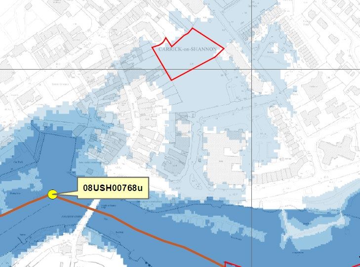
Flynn’s Field Flood Risk & Drainage Assessment

3.3        Flood Mapping

3.3.1      OPW PFRA Mapping

The OPW Preliminary Flood Risk Assessment (PFRA) considered all types of flooding, including natural
sources such as rivers, the sea and estuaries, pluvial and groundwater, and the failure of built infrastructure.
The PFRA map is presented in Figure 3.1 below, and Appendix B2, and shows that there is a risk of fluvial
flooding near to the site. Fluvial flooding indicated on this mapping has not been used as this OPW PFRA
Mapping has been superseded by the more detailed CFRAM mapping, which is referred to in Section 3.3.2 of
this report.

The PFRA map does not indicate any risk of pluvial or groundwater flooding directly affecting the site.

                                                           Flynn’s Field Proposed
                                                           Car Park

   Figure 3.1: OPW PFRA Map

321060BJ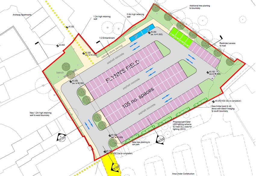
Flynn’s Field Flood Risk & Drainage Assessment

3.3.2      OPW Shannon CFRAM Study – Carrick-on-Shannon Flood Risk Review Report

Flood risk along the River Shannon was assessed as part of the OPW Catchment Flood Risk Assessment and
Management (CFRAM) Study. The predicted flood extents for the River Shannon in Carrick-on-Shannon are
presented in Figure 3.2 below, and Appendix B3, and show that the Flynn’s Field site is located within an area
at risk of flooding in a 0.1% Annual Exceedance Probability (AEP) (1 in 1000 year) fluvial event. The site is not
at risk from flooding for the 1% AEP (1 in 100) fluvial event.

                                                                                    Proposed Car Park on Flynn’s
                                                                                    Field is within the 0.1% AEP (1
                                                                                    in 1000) flood extent

                                River Shannon

Figure 3.2: CFRAM FRA Map

321060BJ
Flynn’s Field Flood Risk & Drainage Assessment
3.3.3 Other Flood Risk Maps
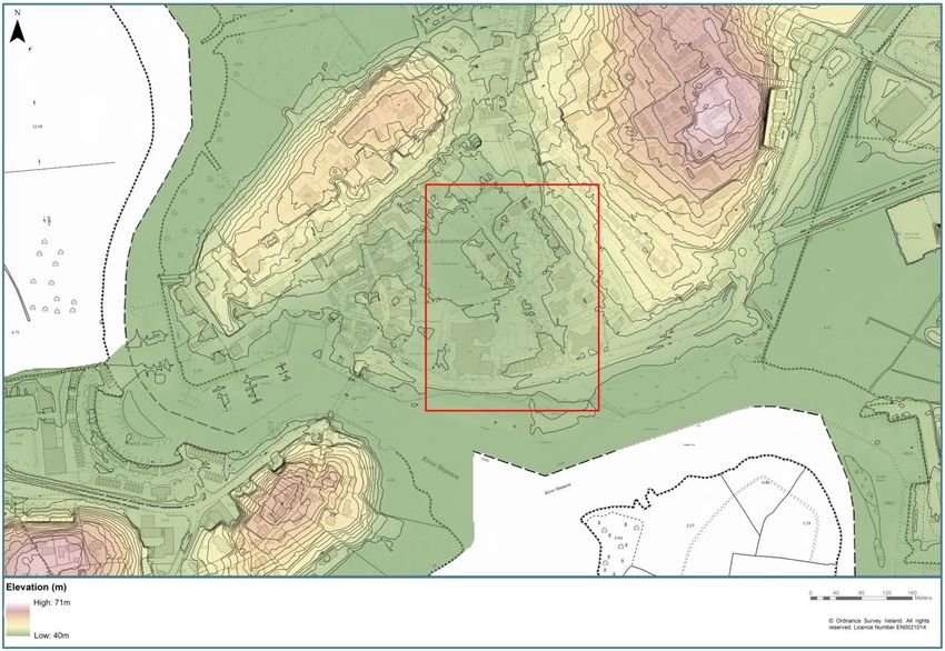
The OSI Historic 6” map is shown in Figure 3.3 and indicates that the site is located on land that is historically
liable to flooding.
Approximate extent of the
proposed Car Park on Flynn’s
Field is within a floodplain
Figure 3.3: OSI Historic 6” map
3.4 Stage 1 Assessment Conclusions
This Stage 1 Flood Risk Assessment has assessed the flood risk to a site that is being considered for works in
Carrick-on-Shannon to develop a new carpark.
From the information obtained it can be concluded that the site is at risk of fluvial flooding from the River
Shannon. The proposed development is located within the 0.1% AEP flood extent as seen in the CFRAM study.
Historical flooding suggests that the risk could however be more frequent with flooding report in both 2009 and
2015.
Stage 2 of this report provides examination of all sources of flooding that may affect the proposed development.
321060BJFlynn’s Field Flood Risk & Drainage Assessment
4. Stage 2: Initial Flood Risk Assessment
This section assesses the risk of flooding to the site once the works have been completed from a range of
different sources, which is then used to develop a broad understanding of the risk characteristics to the
proposed works.
4.1 Potential Sources of Flooding
The potential sources of flooding are as follows:
• Coastal - flooding from the sea;
• Fluvial - flooding from rivers and watercourses;
• Estuarine - flooding from a combination of fluvial and coastal;
• Pluvial - flooding that is caused by runoff during high rainfall events;
• Artificial Drainage Systems - flooding that occurs as a result of surcharging or blocking of drainage
networks;
• Groundwater - flooding when water normally stored below the ground rises above surface level or into
below ground spaces (such as basements).
Due to its inland location and elevation at around 43mOD, it can be concluded that the site is not at risk from
flooding from Coastal or Estuarine sources. Flood risk from these two sources is therefore not considered any
further in this this assessment. The remaining sources of fluvial, pluvial, flooding from artificial drainage
systems and groundwater are discussed in more detail below.
4.2 Fluvial Flood Risk
As discussed in Section 3.2, the CFRAM flood risk maps indicate that the existing site is at risk of flooding from
fluvial sources in the 0.1% AEP event. Table 4.1 compares peak flood levels from the CFRAM study against
the existing and proposed ground levels for the site.
Difference
Difference
between
River between
Existing Proposed Flood Level
Shannon Flood Level
AEP Event Site Level Minimum Site and
Flood Level and Existing
(mOD) Level (mOD) Proposed
(mOD) Site Level
Site Level
(m)
(m)
10% (1 in 10) 41.74 -0.14 +1.36
1% (1 in 100) 42.31 41.6 -0.71 43.1 +0.79
0.1% (1 in 1000) 42.86 -1.26 +0.24
Table 4.1: River Shannon Flood Level vs Existing and Proposed Site Levels
Note – a positive difference denotes that the ground level is higher than the flood level
The proposed works will elevate the site to a new minimum level of 43.1m OD, which is a minimum of 0.8m
above the 1% AEP flood level and 0.24m above the 0.1% AEP flood level. The risk of fluvial flooding to the
proposed car park once the works are complete will therefore be low.
4.3 Pluvial Flood Risk
Pluvial flooding occurs during periods of heavy rainfall, when the rainfall rate is greater than the infiltration
capacity. It is usually associated with high intensity rainfall events (typically > 30mm/h) resulting in overland
flow and ponding in depressions in the topography. In urban situations underground sewerage/drainage
systems and surface watercourses may be completely overwhelmed.
Vector mapping and LiDAR have been used in conjunction with each other to identify the topography of the site
321060BJFlynn’s Field Flood Risk & Drainage Assessment
and the surrounding lands. Figure 4.1 below shows that the site is low lying in relation to the surrounding
topography. This means that the potential for overland flow from surrounding land flowing onto the proposed
development, and ponding on the site, is high.
Fa
Fall ll
Proposed Car Park on Flynn’s Field
would sit within a natural depression.
The site will be raised by up to 1.4m
Fa to 1.6m to meet the level of
ll surrounding lands
Fall
Figure 4.1: Existing Ground Profile
The proposed works will elevate the car park above the existing level by some 1.4m to 1.6m to correspond to
levels on the adjacent Primary Care Centre Site (located to the south). Raising the car park will bring its level
up to meet the surrounding topography to the north, east and west, reducing the risk of runoff from surrounding
areas flowing into the car park. The car park will also include the design of its own drainage system to receive
rainfall falling directly on the site.
Therefore, the risk of pluvial flooding to the car park, once the works are complete, is considered to be low.
4.4 Artificial Drainage Systems
Flooding occurs from artificial drainage systems during periods of heavy rainfall, when the local drainage system
reaches capacity and surcharges from manholes and/or gullies.
Figure 4.2 (see also Appendix B4) shows that there are two 600mm diameter storm pipes crossing the northern
and eastern parts of the site. A gravity sewer runs along the western boundary of the site, however its
dimensions are not known.
From Jacobs’ previous work in this area, it is understood that previous flooding on Flynn’s Field has coincided
with high water levels in the River Shannon with water ponding to a similar level to that in the Shannon. This
flooding has not necessarily occurred directly from the River Shannon overtopping it’s banks, therefore, there
would appear to be a hydraulic connection between the River Shannon and the site. It is considered highly
probable that this connection is via the existing drainage systems which pass beneath the site.
321060BJFlynn’s Field Flood Risk & Drainage Assessment
The proposed works will however elevate the site above the water levels in the River Shannon in the 0.1% AEP
event. Therefore, flood risk to the site from drainage systems being backed-up by the River Shannon once the
works are completed, will be low.
Existing 600mm
storm sewers.
Site boundary
Potential risk of existing
sewers backing-up from
the Shannon and flooding
the site.
Sewer, dimension
not known
Sewers ultimately
discharge to the Shannon
Figure 4.2: Existing Drainage Network
The proposed works will also include the construction of a new surface water drainage system with an
underground attenuation tank that discharges to the existing storm drains (see Section 5.3 for further details).
These drains will be sized appropriately to receive runoff from the car park area and minimise the risk of
flooding on the site during extreme rainfall. These works will also include for the provision of a flap valve to
prevent backing-up of the existing storm drains into the new car park drainage when the Shannon is in flood.
It is also understood that non-return valves have been fitted by Leitrim County Council on the existing storm
drains prior to them outfalling to the River Shannon. This will further reduce the risk of flooding to Flynn’s Field
from the existing artificial drainage systems when water levels in the Shannon are high.
4.5 Groundwater Flood Risk
Groundwater flooding could occur when the River Shannon is in flood, as the site is low lying relative to the
surrounding topography. The site surface is formed from made granular fill which would allow for the
emergence of groundwater when river levels in the Shannon exceed the site ground level, if there is a hydraulic
connection to permeable sub-strata, which are linked to the water table.
Given that the reports of flooding on the site note that water ponds to a similar level as that in the River
Shannon, this would suggest that there is a hydraulic connection and that flooding via Artificial Drainage
systems is more likely (as noted in Section 4.6) than groundwater. This is due to the site being located some
321060BJFlynn’s Field Flood Risk & Drainage Assessment
240m from the river and that a hydraulic headloss would be expected to be observed between the respective
flood levels, if the site was subject to flooding from groundwater that was linked to the Shannon.
This, with the addition of the proposed works elevating the site above the flood level in the River Shannon in the
0.1% AEP event, mean that the flood risk to the site from groundwater can be concluded to be low.
4.6 Flood Risk due to Climate Change
Future climate change is predicted to give rise to an increased risk of flooding through rising sea levels, an
increase in river flows and the frequency and intensity of extreme rainfall. The OPW has identified two potential
scenarios for the impacts of climate change that are known as the Mid-Range Future Scenario (MRFS) and
High-End Future Scenario (HEFS). Table 4.2 summarises the predicted impacts of both scenarios on predicted
river flows and rainfall depths over the next 100 years. The predicted impact on sea level is also provided for
completeness however, as noted in Section 4.1, there is no coastal flood risk within Carrick-on-Shannon.
Parameter Mid-range Future Scenario (MRFS) High-End Future Scenario (HRFS)
Mean Sea Level Rise +500mm +1000mm
River Flows +20% +30%
Extreme Rainfall Depths +20% +30%
Table 4.2 Climate Change Forecasts
The Mid-Range Future Scenario (MRFS) scenario is intended to represent the ‘likely’ future scenario based on
a range of forecasts. The High-End Future Scenario (HEFS) represents a more extreme forecast that is at the
upper end of accepted projections. Given the nature of the works and risk from exposure to flooding, the
potential impact of climate change on flood risk to the Flynn’s Field Car Park site has been made relative to the
more likely MRFS scenario. Table 4.3 summarises the potential impacts of climate change on the Flynn’s Field
Car Park site for each potential source of flooding
Likely Impacts of
Source of
Climate Change Discussion
Flooding
on Flynn’s Field
There is no coastal flood risk in Carrick-on-Shannon, even
Coastal No Impact
with the effects of future climate change
Fluvial No change See Tables 4.4 and 4.5 below
There is no estuarine flood risk in Carrick-on-Shannon, even
Estuarine No Impact
with the effects of future climate change
Whilst future climate change will result in increased rainfall
depths over the site, this will not result in an increase in the
risk of pluvial flooding. The site is being raised relative to
Pluvial No change
surrounding lands and its design will include new drainage
that allows for the effects of future climate change for runoff
that will be generated within its catchment area
A non-return valve will be incorporated into the design of the
car park drainage to prevent flows backing-up from the
Artificial Drainage
No change Shannon. The car park drainage will also be designed to be
Systems
near to the surface e.g. ACO drains or similar to reduce the
risk of influence from the Shannon
No change; the elevation of the works mean they will continue
Groundwater No Impact
to be at a low risk of groundwater flooding.
Table 4.3 Climate Change Impacts
A 20% increase in river flows is predicted for the River Shannon due to future climate change. Table 4.4 shows
this will result in a 0.38m increase in the 1% AEP flood level and 0.39m increase in the 0.1% AEP flood level.
Future climate change will therefore mean a risk of flooding to the car park for a 0.1% AEP flood due to future
climate change but the car park will still not be at risk for the 1% AEP & climate change flood level; as outlined
in Table 4.5. Section 6 of this report however demonstrates that as the car park will be classified as a ‘less
321060BJFlynn’s Field Flood Risk & Drainage Assessment
vulnerable development’; this increase in flood risk would be acceptable, as the car park will still be located in
the appropriate flood zone for its development type, in accordance with the ‘Planning System and Flood Risk
Management: Guidelines for Planning Authorities’.
River Shannon Flood Level (mOD)
AEP Event Difference (m)
Existing MRFS Climate Change
10% (1 in 10) 41.74 42.02 +0.28
1% (1 in 100) 42.31 42.69 +0.38
0.1% (1 in 1000) 42.86 43.25 +0.39
Table 4.4: Impact of Climate Change on River Shannon Flood Levels
River
Existing
Shannon Difference Proposed Site Difference
AEP Event Site Level
Flood Level (m) Level (mOD) (m)
(mOD)
(mOD)
10% (1 in 10) 42.02 -0.42 +1.08
1% (1 in 100) 42.69 41.6 -1.09 43.1 +0.41
0.1% (1 in 1000) 43.25 -1.65 -0.15
Table 4.5: River Shannon MRFS Flood Levels vs Existing and Proposed Site Levels with Climate Change
Note – a positive difference denotes that the ground level is higher than the flood level
It can therefore be concluded that future climate change will not significantly change the risk of flooding to the
site for Coastal, Estuarine, Pluvial, Artificial Drainage or Groundwater sources.
There is an increased risk of fluvial flooding to the site due to climate change, however this is deemed to be
acceptable for this site due to the low vulnerability and resulting flood zone designation of the site with respect
to flood risk, in accordance with the ‘Planning System and Flood Risk Management: Guidelines for Planning
Authorities’.
4.7 Summary of Flood Risk
Table 4.6 below provides a summary of the outcome of this Stage 2 Initial Flood Risk Assessment. It outlines
the potential impact from each of the sources of flooding considered, to the site once the works are completed.
Summary of
Flood Risk
Impact on Flynn’s Summary Information
Source
Field
Coastal &
Not applicable Not applicable
Estuarine
The site will be raised above the level of the 0.1% AEP event.
Future climate change will place the site at risk for a 0.1% AEP
Fluvial Low
flood however this will be acceptable as the site will still be located
in the appropriate flood zone for its development type.
The site will be raised above surrounding ground levels and include
Pluvial Low
its own bespoke drainage design
Artificial
The site will be raised above surrounding ground levels and include
Drainage Low
its own bespoke drainage design
Systems
The risk of groundwater flooding is considered to be low. The site
Groundwater Low
will also be raised above the 0.1% AEP flood level.
Table 4.6: Flood Risk Summary
321060BJFlynn’s Field Flood Risk & Drainage Assessment
5. Potential Flood Risk Impacts from the Proposed Works
Section 4 considered the flood risk to the site once the works were complete. This section considers the
potential change in flood risk to the surrounding areas arising from the proposed works, and outlines any
necessary mitigation to ensure no increase in the risk of flooding.
5.1 Impacts on Coastal & Estuarine Flooding
Due to the location and elevation of the site, it will have no effect on the coastal or estuarine flooding.
5.2 Impacts on Fluvial Flooding
The proposed development could result in an increase in the risk of fluvial flooding if it were to:
• Reduce conveyance along any existing watercourses and floodplain network;
• Reduce the volume of floodplain storage available; or
• Increase runoff rates and volume.
Sections 3 showed that the site had been subject to historical flooding due to flows backing-up the existing
drainage network. Raising the site level for the construction of the proposed car park will prevent this flooding
occurring on the site in the future. It is also understood that non-return valves were fitted to the existing storm
sewers at their outfalls to the River Shannon following the 2015 flood, which should already prevent flooding of
Flynn’s Field from Shannon flows backing-up the drainage network.
Section 4 outlined that during the 0.1% AEP flood event, direct flooding of the site from the River Shannon
overtopping its banks could occur. Raising the level of the site will therefore result in a small loss in floodplain
during the 0.1% AEP flood.
3
Table 5.1 shows that the total floodplain lost during the 0.1% AEP flood is approximately 5,280m . This is
unlikely to impact on flood levels in the River Shannon however as, during the 0.1%AEP flood, this area will be
filled in around 18-seconds due to the large flood volumes in the river.
Site Details River Shannon 0.1% AEP Flood Details
0.1% AEP Flood Depth
3
on current Flynn’s Field 1.2m 0.1% AEP Peak Flow 285m /s
Car Park site
0.1% AEP Flood
Flynn’s Field Car Park 2 Volume passing through 3
4,400m 17,100m
Car Park Area: Carrick-on-Shannon per
minute
Floodplain Volume Lost Time to fill lost
3
due to Flynn’s Field Car 5,280m floodplain due to Flynn’s 18-seconds
Park raising Field Car Park
Table 5.1: Flood Volume Displacement Assessment
It is therefore concluded that the proposed works do not impact on fluvial flood risk. The impacts on runoff rates
and the proposed mitigation are outlined in Sections 5.3 and 5.4 below.
5.3 Impacts on Pluvial Flooding
To assess any impact of the proposed works on pluvial flood risk, the following conditions need to be
considered:
• If the proposed upgrade works increase the rainfall runoff rate;
321060BJFlynn’s Field Flood Risk & Drainage Assessment
• If the proposed upgrade works alter existing flow or drainage paths.
Raising the site and changing its surface to an impermeable material will increase the rainfall runoff rate. To
mitigate against this change, attenuation storage will be provided on the site to ensure no increase on the
existing runoff rate.
To determine the requirements for onsite attenuation storage, an analysis was completed using the IH 124
small catchments method and found that runoff from the site needed to be capped to 2l/s to ensure no increase
in runoff rates from Flynn’s Field.
A 2l/s flow caps runoff to the QBAR rate; this rate was selected as this is the minimum flow that can reasonably
be achieved without encountering maintenance issues in the flow control. This figure will be reviewed at
detailed design stage with further refinement made as necessary to suit the selected flow control device.
Runoff Attenuation Design Parameters
Runoff Calculation
2
Total Site Area 4,482m
2
Greenfield Areas 958m
Paved / Impermeable Areas of the Proposed 2
3,524m
Development
Soil Factor 0.3
SAAR 1044
2l/s
(capping to QBAR; 2l/s taken as minimum flow that
Maximum Permitted Runoff Rate
can be sensibly achieved without encountering
maintenance issues in the flow control)
Storm Tank Sizing
Storm Tank Required Volume 3
201m
(to contain 1% AEP storm & climate change)
Top Level of Attenuation Storm Tank 42.4mOD
Invert of Attenuation Tank 41.2mOD
Storm Tank Dimensions
(Approx - Width x length x depth; based on 15.9m x 13.7m x 1.2m
StormTech Provision)
Minimum cover to top of storm tank
0.6m (600mm)
(based on use of StormTech units)
Approximate depth of excavation (from existing
0.4m (400mm)
ground levels)
Outflow control Hydrobrake
Table 5.2: Attenuation Tank Design Parameters
Drawings 1 and 2 in Appendix C outline the indicative proposals for an underground attenuation tank that are
proposed to be built beneath the car park to receive, store and attenuate runoff from the car park. The
321060BJFlynn’s Field Flood Risk & Drainage Assessment
3
attenuation tank will have a net storage volume of 201m and will be fitted with a hydrobrake (or similar flow
control) on its outlet to cap the rate of runoff to the maximum 2l/s. The volume of the attenuation tank is
designed to contain the 1% AEP storm with an allowance for future climate change.
The attenuation tank will be connected to an existing 600mm diameter surface water drain that passes beneath
the site. A flap valve will be included at this connection to prevent flooding of the attenuation area from the
Shannon backing-up this drain. At 600mm diameter, this receiving drain has a capacity of approximately 500l/s
and is already receiving flows from Flynn’s Field. The outflow from the car park attenuation tank will use 0.4%
of the potential storm drain capacity.
Final elevations and drainage paths for the car park surface are still to be confirmed as part of the car park
layout design, however it is recommended that ACO or similar type surface water drains be used to collect and
divert runoff to the attenuation tanks. This has two important benefits:
• It minimises the depth of the attenuation tank so reducing the risk of groundwater during excavation;
• It should ensure that a gravity connection to the existing sewer can be made.
Presently, Flynn’s Field is a natural low spot compared to surrounding lands. Raising Flynn’s Field to 43.1mOD
to form the car park will ensure that it ties into surrounding lands and will not create any new low spots that
might be prone to surface water flooding.
5.4 Impacts on Flooding from Artificial Drainage Systems
As noted, flooding of Flynn’s Field currently occurs from the Shannon backing-up the drainage network. Once
the site is elevated above the level of the 0.1% AEP flood, flooding of the site from drainage system for events
up to the 0.1% AEP event will not occur. A flap valve will also be included at the connection between the new
runoff attenuation area and existing storm drain to prevent flooding of the attenuation area from the Shannon
backing-up the existing drains. As noted, non-return valves have already been fitted on these storm drains,
which already reduces the risk of flows backing up these drains when the Shannon is in flood.
Flooding from the existing storm drains will not be increased by the Flynn’s Field car park works as the new
attenuation tank will ensure existing runoff rates from the site are maintained.
5.5 Impacts on Groundwater Flooding
The indicative design for the storm tank which is presented in Appendix C minimises the need for extensive
excavation or any significant groundworks. The tank has been located on the site to take advantage of where
existing ground levels are lowest. The indicative design assumes that approximately 400mm of excavation will
be required, with 300mm of this made up by a regulating granular fill for the attenuation tank.
321060BJFlynn’s Field Flood Risk & Drainage Assessment
5.6 Summary of Potential Flood Risk Impacts from the Upgrade Works
Table 5.3 below provides a summary of the potential flood risk impacts on surrounding areas as a result of the
proposed development.
Summary of Impact from
Flood Risk Notes
Flynn’s Field Car Park
Coastal &
N/A N/A
Estuarine
Flood risk from fluvial sources to the surrounding area will
Fluvial No Impact
not be increased
Flood risk from pluvial sources to the surrounding area will
Pluvial No Impact not be increased. Mitigation measures are proposed as
described in section 5.3
Artificial Flood risk from artificial drainage systems sources to the
Drainage No Impact surrounding area will not be increased. This is linked to the
Systems runoff mitigation measures described in Section 5.3
Flood risk from Groundwater sources to the surrounding area
Groundwater No Impact
will not be increased
Table 5.3: Flood Risk Impact Summary
321060BJFlynn’s Field Flood Risk & Drainage Assessment
6. Flood Risk Management and Evaluation
6.1 The Sequential Approach to Development Planning
‘The Planning System and Flood Risk Management Guidelines for Planning Authorities’ recommend that a
sequential approach is taken for flood risk management for new developments. This mechanism is summarised
in Figure 6.1 below.
Figure 6.1: Sequential approach mechanism in the planning process (The Planning and Flood Risk Management, Guidelines
for Planning Authorities’ (2009))
Flood Zone Notes
Where the probability of flooding from rivers and the sea is highest (greater than
Zone A
1% or 1 in 100 for river flooding or 0.5% or 1 in 200 for coastal flooding)
Where the probability of flooding from rivers and the sea is moderate (between
Zone B 0.1% or 1 in 1000 and 1% or 1 in 100 for river flooding and between 0.1% or 1 in
1000 year and 0.5 % or 1 in 200 for coastal flooding)
Where the probability of flooding from rivers and the sea is low (less than 0.1% or 1
Zone C in 1000 for both river and coastal flooding). Flood zone C covers all areas of the
plan which are not in zones A or B.
Table 6.1: Description of Flood Zones (The Planning and Flood Risk Management, Guidelines for Planning Authorities’ (2009))
Table 6.1 describes the flood risk assigned to each Flood Zone.
Flynn’s Field is at risk of fluvial flooding in the 0.1% AEP flood although the exact risk is unknown. Based on
the CFRAM mapping the site is located in Flood Zone B although it is possible, given the recent frequency of
flooding in 2009 and 2015, that it could be considered to be located in Flood Zone A.
321060BJFlynn’s Field Flood Risk & Drainage Assessment
A key part of the proposed works at Flynn’s Field will be to elevate the site so that the finished level of 43.1mOD
exceeds the 0.1% AEP flood level. Following completion of the work the site would therefore be located in
Flood Zone C, as described in Table 6.1 above.
With reference to Table 3.1 of ‘The Planning System and Flood Risk Management Guidelines for Planning
Authorities’ published by the OPW, the proposed scheme falls under the land use and type of “Local transport
infrastructure.” In accordance with The Planning System and Flood Risk Management Guidelines for Planning
Authorities, the proposed scheme is therefore classed as a ‘Less Vulnerable Development’.
Table 6.2, extracted from The Planning System and Flood Risk Management Guidelines for Planning
Authorities, illustrates the types of development that are considered appropriate to each Flood Zone. The
proposed development on Flynn’s Field is appropriate both for its current designation (Flood Zone B) and also
following completion of the works (Flood Zone C).
Therefore, it can be concluded that the Justification Test will not be a requirement as part of this assessment.
Flood Zone A (High Flood Zone B (Moderate Flood Zone C (Low
Probability of Flooding) Probability of Flooding) Probability of Flooding)
Highly Vulnerable
Justification Test Justification Test Appropriate
Development
Appropriate Appropriate
Less Vulnerable
Justification Test (current designation & (with completed scheme
Development
future climate change) designation)
Water-Compatible
Appropriate Appropriate Appropriate
Development
Table 6.2: Matrix of vulnerability versus flood zone to illustrate appropriate development and that required to meet the
Justification Test
321060BJFlynn’s Field Flood Risk & Drainage Assessment
7. Conclusions and Recommendations
7.1 Conclusions
This report provides an assessment of the flood risk issues that could affect the development of a proposed car
park on Flynn’s Field and the surrounding area. The assessment has included desktop investigations into the
potential flood risks and an assessment of the potential impacts the development could have on flood risk in the
surrounding areas.
The assessment found that Flynn’s Field had been subject to flooding from the River Shannon due to backing-
up of the drainage network which passes beneath the site. This risk has been considered in the design of the
new car park and mitigation measures have been considered with the finished ground levels to be elevated
above the 0.1% AEP flood to mitigate this risk.
Construction of the new car park will result in the creation of new impermeable surfaces on Flynn’s Field which
have the potential to increase flood risk locally from surface water and exceed the capacity of the adjacent
storm drains. An indicative design for new runoff attenuation tanks to be built beneath the car park has been
provided that will ensure no increase on existing runoff rates following completion of the works. The attenuation
3
tanks will provide 201m of storage and cap runoff rates from the car park to 2l/s. The tank has also been
designed to minimise the required depth of excavation due to the potential risk of groundwater flooding in the
area.
The design of the car park to elevate it above the 0.1% AEP flood level mean it will be located in Flood Zone C
following completion of the works and at a low risk of flooding. The risk of fluvial flooding will increase to
moderate (Flood Zone B) due to future climate change and will result in the site being at risk for the 0.1% AEP
flood in the future. The designation of the site as a ‘less vulnerable development’ in the Planning System and
Flood Risk Management Guidelines for Planning Authorities, means that this can be accepted, as proposed car
park will still be located in the appropriate flood zone (Flood Zone B, moderate risk).
Therefore, it was concluded that the Justification Test will not be a requirement as part of this assessment.
7.2 Recommendations
It has been concluded that both flood risks and impacts associated with the proposed development are low and
negligible. Full mitigation can also be provided to ensure no increase in runoff from the site by the provision of
runoff attenuation. Therefore, it is recommended that further detailed modelling, i.e. a Stage 3 Detailed Risk
Assessment, is not required.
It should be noted that that the attenuation tank drawings in Appendix C only provide a schematic and indicative
details for the proposed works. Further work will be required following confirmation of the finished profile of the
car park to allow the nature of its drainage network to be full developed. The indicative design has assumed the
provision of ACO or similar surface drains to minimise the required depth of excavation for the attenuation
tanks, which is also considered necessary to allow for connection to the existing surface water drainage
network. Investigation of the receiving drainage network is also required to verify the design level for the tank.
Further assessment of groundwater pressures will also be required to consider the potential impacts of uplift in
the design of the attenuation tank
321060BJFlynn’s Field Flood Risk & Drainage Assessment
Appendix A. Information Sources Checklist
No. Information Source Status Reference/Comments
OPW Preliminary Flood Risk Assessment
1 √ Please refer to Appendix B
indicative fluvial flood maps
National Coastal Protection Strategy
2 N/A
Study flood and coastal erosion risk maps.
Predictive and historic flood maps, and
3 √
Benefiting Lands Map
Predictive flood maps produced under the
4 √ Please refer to Appendix B
CFRAM studies
Carrick-on-Shannon Local Area Plan 2010 –
River Basin Management Plans and
5 √ 2016 Flood Risk Mapping and Strategic
reports
Drainage Area Map
Indicative assessment of existing flood
Shannon CFRAMS Flood Risk Review for
6 risk under Preliminary Flood Risk √
Carrick-on-Shannon
Assessment
Previous Strategic Flood Risk
7 N/A
Assessments
Expert advice from OPW who may be able
to provide reports containing the results of
detailed modelling and flood-mapping
8 N/A
studies including critical damage areas,
and information on historic flooding and
local studies etc.
Topographical maps, in particular digital
elevation models produced by aerial √
9 survey or ground survey techniques.
Information on flood defence condition
10 N/A
and performance
11 Alluvial deposit maps N/A
321060BJFlynn’s Field Flood Risk & Drainage Assessment
‘Liable to Flood’ markings on the old 6”
12 √ Historic OSI 6” Map - Appendix E
Inch Map
Adequate information on Flooding History was
13 Local Libraries and newspaper reports √
provided by OPW floodmaps.ie
Interviews with local people, local history/
14 X
natural history societies etc.
Walkover survey to assess potential
sources of flooding, likely routes for flood
15 X
water and the site's key features, including
flood defences, and their condition.
321060BJFlynn’s Field Flood Risk & Drainage Assessment
Appendix B. Schemes Drawings and Flood Risk Mapping
Information
Appendix B1 – Scheme Layout
Appendix B2 – PFRA Flood Mapping
Appendix B3 – CFRAM Flood Mapping
Appendix B4 – Existing Drainage Layout
321060BJN
The Bush Hotel
Existing pedestrian access via Archway Apartments
to Main Street to be maintained.
Future further development of this area may include upgrading of
surfaces, public lighting and alterations to gradients subject to
agreement between Leitrim County Council and Carrick on
Shannon Archway Management Company (Company Limited by
Guarantee).
Additional tree planting
to boundary
Archway Apartments 0.8m high retaining
1.2m high retaining wall
wall
43.392
43.200 ec
(ex. lvl 41.893) ar
ec
1:2 Embankment ar
ec
ar
ec Restricted access
43.488 ar
ing
to road
av
ep
43.300 s ton
(ex. lvl 42.232)
tu ral cre
te
na co
n
alt
ph
as
LD
FIE
bench 'S 43.100
NN
(ex.lvl 41.520)
Y
43.200
(ex. lvl 42.098) FL co
n cre
te
alt
ph
as
e s
ac
. sp
no (43.250 HSE Site on completion)
1 05 co
nc
ret
e
New timber post & rail
fence with beech hedging
alt to south boundary
New 1.2m high retaining ph
wall to west boundary as
Proposed perimeter
LED lighting scheme
to meet SLL code for
lighting (2012)
43.100
K 9 (ex. lvl 41.929)
-20 J 8
PL -20
New tree planting to PL
car park
43.100
(43.100 HSE Site on completion)
I
-2 08
PL
Area Under Construction
Possible future connection
to existing footpath
Wayleave
Possible pedestrian access
to Bridge Street
by other
Key Project: Stage:
site boundary Carrick on Shannon Public Realm Planning
site notice
Client: Project No.: Date:
wayleave
Leitrim County Council 18-14-CPR 19.11.18
Drawing Title: Drawing No: Revision:
General Notes:
Proposed Site Plan -Flynn's Field
PL-107 A
Scale : Scale: Drawn by: Approved by:
This is a computer generated map, produced under licence from 1/500 0 2 4 6 8 10 (m.)
Ordnance Survey Ireland. All rights reserved. 1:500 dhb dhb
Licence No: 2010/16 CCMA Leitrim.© Government of Ireland
Osi permit number EN-002-1011
kLEITRIM
j Location Plan :
¯
Legend:
Flood Extents
Fluvial - Indicative 1% AEP (100-yr) Event
Fluvial - Extreme Event
CARRICKONSHANNON Coastal - Indicative 0.5% AEP (200-yr) Event
Coastal - Extreme Event
j
k
Pluvial - Indicative 1% AEP (100-yr) Event
Pluvial - Extreme Event
Groundwater Flood Extents
Lakes / Turloughs
PFRA Outcomes
No Fluvial Data Available For Area JAMESTOWN k
j Probable Area for Further Assesment
j
k j
k Possible Area for Further Assesment
Important User Note:
j
k
The flood extents shown on these maps are based on broad-
scale simple analysis and may not be accurate for a specific
location. Information on the purpose, development and
limitations of these maps is available in the relevant reports
(see www.cfram.ie). Users should seek professional advice if
they intend to rely on the maps in any way.
If you believe that the maps are inaccurate in some way please
forward full details by contacting the OPW (refer to PFRA
Information leaflets or ‘Have Your Say’ on www.cfram.ie).
Office of Public Works
Jonathon Swift Street
Trim
Co Meath
Ireland
Project :
PRELIMINARY FLOOD RISK ASSESMENT (PFRA)
Map :
PFRA Indicative extents and outcomes
- Draft for Consultation
Figure By : PJW Date : July2011
Checked By : MA Date : July 2011
Figure No. : Revision
2019 / MAP / 317 / A 0
Drawing Scale : 1:50,000 Plot Scale : 1:1 @ A3
0.5 0.25 0 0.5 1 1.5 2 2.5 3 3.5 4 4.5 5
KilometersLocation Plan:
193000 193500 194000
10US H00000u
!
(
)
Ri
( ve r
n
nno
S ha
Le g e n d:
299500
299500
!
( Nodes
Model Reach
AFA Boundary
09US H00000u
Flood Defence: Wall
!
(
Kn ockan an i
m a(
Rive r)
08US H00768u Flood Defence: Embankment
!
(
Defended Area
!
(
10% AEPFl
uvi
alFl
oodExte n t
(1 in 10 chance in any given year)
ve r)
!
( 01MUL00179
!
( n Ri
(
nn o 1% AEPFl
uvi
alFl
oodExte n t
S ha
08US H00285u (1 in 100 chance in any given year)
0.
1% AEPFl
uvi
alFl
oodExte n t
(1 in 1000 chance in any given year)
299000
299000
I
MPORTANTUS ERNOTE:
THE VIEWER OF THIS MAP SHOULD REFER
TO THE DISCLAIMER, GUIDANCE NOTES AND
CONDITIONS OF USE THAT ACCOMPANY
!
(
THIS MAP.
The Office of Public Works Merrion House
Jonathan Swift Street Merrion Road
Trim Dublin 4
10% AEP 1% AEP 0.
1% AEP Co. Meath D04 R2C5
C15 NX36
Node Labe l Wate r Le ve l TotalFlow Wate r Le ve l TotalFlow Wate r Le ve l TotalFlow Project: SHANNON CFRAM STUDY
(
m OD) (m ᶟ/
s) (
m OD) (m ᶟ/
s) (
m OD) (m ᶟ/
s) Map Type: EXTENT
Source: FLUVIAL
10USH00000u 41.76 160.96 42.33 225.39 42.88 283.91
Area: CARRI
CKONS HANNON
09USH00000u 41.74 160.94 42.32 222.85 42.87 277.08 Scenario: EXISTING
Drawn by: EF Date: JULY 2016
08USH00768u 41.74 161.51 42.31 222.71 42.86 278.21
Checked by: PT Date: JULY 2016
08USH00285u 41.65 42.21 42.68 Reviewed by: PT Date: JULY 2016
Approved by: PS Date: JULY 2016
298500
298500
01MUL00179 44.04 44.24 44.31
Map Number: S2526COS_EXFCD_F1_03
193000 193500 194000 Sheet: 3 of 9 Revision: 0
0 50 100 200 300 400
Meters
500 [ © Ordnance Survey Ireland. All rights reserved. Licence Number EN0021014 Scale:1:5000 Plot Scale: 1 : 1 @ A3Flynn’s Field Flood Risk & Drainage Assessment Appendix C. Indicative Attenuation Storage Drainage Design 321060BJ
Manhole for Attenuation LEGEND
Tank maintenance
n Indicative new Storm
ctio
Se 2 Drain
New manhole with Hydrobrake to attenuate ACO/Slot Drain or
carpark runoff to maximum permitted similar
discharge of 2 l/s based on existing runoff rate
Existing Storm Water
Pipe
Indicative discharge manhole to existing storm drain.
Manhole to contain flap valve on incoming pipe to prevent Manhole
43.392
backflows into the storage area when the Shannon is in flood.
43.200 Petrol Interceptor
(ex. lvl 41.893)
43.488
43.300
(ex. lvl 42.232) ACO M150D 0.0 Channel or similar
Existing Storm Drain approximate invert
of 40.8m AOD at connection point
43.100
(ex.lvl 41.520)
Stormtech MC-3500 Attenuation Tanks
or similar to provide a volume of 201m3
43.200
(ex. lvl 42.098)
(43.250 HSE Site on completion) Manhole for Attenuation
Tank maintenance
43.100
n
(ex. lvl 41.929) Indicative location of manhole recieving carpark 1 Final
Se 1
c tio
drainage network (subject to carpark design)
43.100
(43.100 HSE Site on completion) Merrion House,
Merrion Road,
Dublin,
Co Dublin
Aras An Chontae,
At. Georges Terrace,
Carrick on Shannon,
Co Leitrim
Flynns Field Carpark FRA Drawing 1:
Indicative
23/11/2018 Drainage
Attenuation
Non Standard LayoutIndicative location of manhole recieving carpark
drainage network (subject to carpark design) LEGEND
Kingspan Klargester Class 4 Bypass Separator or similar accepted Existing Ground Level
Manhole for Attenuation Tank maintenance Indicative New Ground
Level
Gravel Fill (300mm Min) Indicative discharge manhole to existing storm drain.
Gravel Fill
PARKING GRASSED VERGE TWO LANE CARRIAGEWAY PARKING PAVEMENT EMBANKMENT
Manhole to contain flap valve on incoming pipe to prevent
backflows into the storage area when the Shannon is in flood.
BUSHES HOTEL GARDENS
1:3 Embankment
43.175m AOD
PROPOSED GROUND LEVEL
42.8m AOD
FILL EXISTING GROUND LEVEL
FILL 0.5m high retaining wall
41.4m AOD
40.8m AOD
15.942m
Existing Storm Drain approximate
invert of 40.8m AOD at connection point
New manhole with Hydrobrake to attenuate
carpark runoff to maximum permitted
discharge of 2 l/s based on existing runoff rate
Stormtech MC-3500 Attenuation Tanks
or similar to provide a volume of 201m3
Gravel Fill (230mm Min)
Section 1
Stormtech MC-3500 Attenuation Tanks
or similar to provide a volume of 201m3
1 Final
Gravel Fill (300mm Min)
13.67m
43.1m AOD
42.8m AOD Merrion House,
PROPOSED GROUND LEVEL
Merrion Road,
FILL Dublin,
Co Dublin
EXISTING GROUND LEVEL 41.13m AOD
Aras An Chontae,
At. Georges Terrace,
Existing Storm Drain approximate invert of 40.8m AOD at connection point Carrick on Shannon,
Co Leitrim
Gravel Fill (230mm Min)
Flynns Field Carpark FRA Drawing 2:
Indicative
23/11/2018 Drainage
Attenuation
Non standard Sections
Section 2You can also read